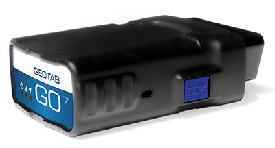
Geotab, a telematics engineering company, has launched its new GO7 telematics device. The GO7 allows fleet management applications to receive vehicle data communications from the engine, drive train, instrument cluster and other subsystems.
The Geotab GO7 is the newest device in Geotab’s line of telematics solutions and has added a number of new features such as programmable CANBUS, OBD, J1708 connection pins, enhanced auto-protocol detection and higher sensitivity accelerometer — making the solution future-proof and cost effective for any fleet to install and maintain, the company said.
The GO7 is an plug-and-play device with internal antennas that eliminates installation and out-of service vehicle time, which significantly lowers installation costs and improves fleet productivity, according to Geotab. The latest edition of Geotab’s GO devices caters to more than one vehicle protocol at a time, allowing the device to collect data simultaneously for all possible datasets, such as RPM, VIN, fuel level, seat-belt detection and odometer. The secondary protocol support provides detailed engine data for a variety of vehicles, including Ford, GM, Chrysler, Volvo and Mazda. The technology is scalable, from light duty, medium duty, to heavy commercial trucks in addition to supporting all major vehicle manufacturers globally, Geotab said.
Photo: Geotab
“Our goal is to provide the most advanced and efficient telematics solution in the industry,” said Neil Cawse, CEO, Geotab. “Together with our MyGeotab software, the all-new GO7 device allows us to provide our customers with the most sophisticated end-to-end fleet management solution on an industry leading platform — providing great productivity enhancements, safety features and cost-savings to our fleet customers.”
Top features of the GO7 include:
Easy plug-and-play installation
External device expandability via IOX Technology
Intelligent in-vehicle driver coaching
Small form factor device
Breakthrough accident detection and notification
Accurate engine diagnostics, DTC, and proprietary engine data
Real-time vehicle data
Fast GPS acquisition time using Almanac OTA support
Agilis Systems, LLC, a provider of GPS-based software solutions for businesses, now offers MOTOsafety Teen Driving Coach — a specialty consumer product designed to help parents monitor location and driving behaviors of their teenage drivers.
According to the National Highway Traffic Safety Administration (NHTSA), inexperience and speeding are top contributors to teen automobile accidents. The team at Agilis recognized this as an opportunity to leverage the company’s experience improving safety ratings of professional drivers to develop a similar product that would help young drivers become better, safer drivers.
Expanding Agilis’ product line to include a consumer product that will help teens stay safer on the roads was an easy step to take, says Agilis Systems’ President and CEO, David Barford. “Most of us here at MOTOsafety are parents. I, myself, am the father of four children. I know the stress and worry you feel as a parent the first time you hand the keys to a new driver. So evolving our technology from business use to helping safeguard and teach our kids… absolutely. It was a must-do.”
Photo: Agilis Systems
Agilis Systems developed MOTOsafety in collaboration with a former police officer and driving school owner and an advisory board of parents.
MOTOsafety was first offered to the public with a soft launch in 2011. Today, MOTOsafety is the largest and most trusted GPS teen-driving product on the market.
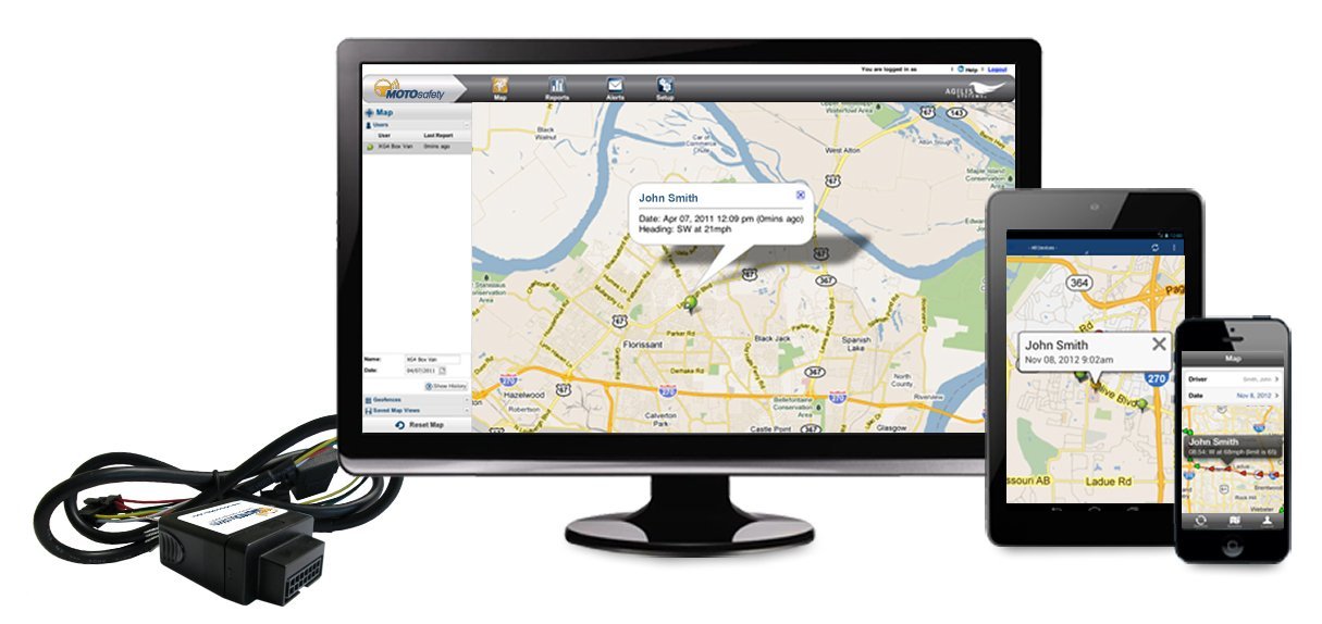
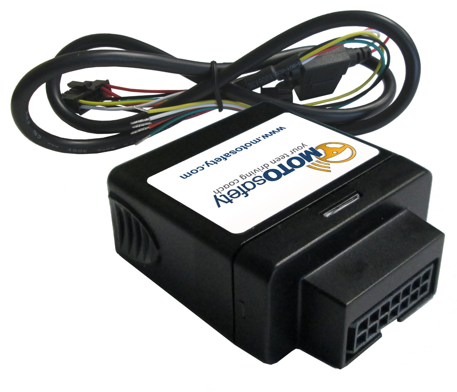
MOTOsafety is a web-based software and mobile app that provides parents with real-time and historical information on their child’s daily driving habits. Data is collected using a small GPS device that installs directly into the vehicle. Customers may choose between a removable plug-in tracker or a hard-wired option. Both devices are small in size, easy to install, and are not visible in most vehicles.
Parents login to secure web-based software to review daily reports on speed, rapid acceleration, harsh braking, routes traveled, and times and locations of driving activities. The MOTOsafety software also allows parents the option to set approved driving hours and designate geofences — customizable, virtual mapped boundaries where their child may or may not travel. Parents may also opt to receive real-time text or email alerts if their teen driver violates speed limits or other established rules, or if the MOTOsafety device is removed from the vehicle.
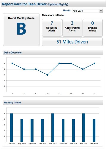
Another MOTOsafety feature is the Daily Driver Report Card. This specially designed report provides a summary of the prior day’s driving activity in a familiar letter-grade format. The Report Card is automatically emailed each day, and serves as a coaching tool for parents to review with their child and facilitate on-going conversation on his or her driving performance, safe driving practices, and goals for improvement.
The Land Transport Authority (LTA) of Singapore is seeking to develop Singapore’s next-generation electronic road-pricing system, based on GNSS technology, reports AsiaOne News.
LTA has shortlisted three consortia to participate in a tender to develop the system: NCS Pte Ltd & MHI Engine System Asia Pte Ltd, ST Electronics (Info-Comm Systems) Pte Ltd, and Watchdata Technologies Pte Ltd & Beijing Watchdata System Co Ltd.
The contract to design and develop the system is expected to be awarded in the second half of 2015. The system is to be implemented in 2020.
Following an 18-month system evaluation test that concluded in December 2012, LTA said that it has found that it is technologically feasible to develop a GNSS-based road-pricing system in Singapore. The system will overcome the constraints of physical gantries, which are costly, difficult to maintain, and take up land space.
The GNSS-based system will implement distance-based pricing along certain congested roads, where motorists will be charged proportionate to the distance traveled. An interactive and intelligent on-board unit in motorists’ vehicles will support additional services such as real-time traffic information and electronic payment for parking fees.
LTA is considering new policies for off-peak travelers.
The Consumer Electronics Association (CEA) has announced that Boo-Keun Yoon, president and CEO of Samsung Electronics, will deliver the keynote address at the 2015 International Consumer Electronics Show. The International CES will take place in Las Vegas, January 6-9, and Yoon will talk at 6:30 p.m. January 5 in the Palazzo Ballroom at the Venetian.
Yoon will discuss connected devices, the future of the Internet of Things (IoT), and the vision of the smart home. He also will focus on Samsung’s vision of strategic partnerships that will drive the next wave of technology breakthroughs.
“Samsung is widely-known for its disruptive technologies and business models, and has been one of the fastest growing CE brands in the world,” said Gary Shapiro, president and CEO, CEA. “Samsung amazes at each CES with its innovative products spanning the entire tech ecosystem. We welcome Boo-Keun Yoon back to the keynote stage for the 2015 CES.”
Yoon began his career at Samsung Electronics in 1978. After serving in a number of leadership positions at Samsung Electronics, Yoon headed Samsung’s Visual Display Business from 2007, seeing its revenue double while maintaining the company’s No. 1 global TV market share for eight consecutive years. Currently, Boo-Keun Yoon serves as the president and CEO of Consumer Electronics at Samsung Electronics, leading Samsung’s Visual Display, Digital Appliances, Printing Solutions and Health & Medical Equipment Business. In addition, Yoon also acts as the company’s Chief Design Officer.
According to CEA/GfK research, global consumer technology spending will top more than $1 trillion in 2015. Lauded for its innovative design and technology across its diverse portfolio of products, Samsung Electronics is a leading global brand for high-tech electronics and digital media.
The 2015 CES will feature more than 3,500 exhibitors unveiling the latest consumer technology products and services across the entire ecosystem of consumer technologies. For more information on the 2015 CES, visit CESweb.org.
Aireon LLC, developer of a space-based ADS-B global air traffic surveillance system, is planning the Aireon Aircraft Locating and Emergency Response Tracking (Aireon ALERT) service, a global emergency tracking service that will be provided free of charge to the aviation community beginning in 2017. The Aireon ALERT service will allow rescue agencies to request the location and last flight track of any 1090-MHz ADS-B equipped aircraft flying in airspace currently without surveillance.
“A comprehensive, global aircraft tracking solution is essential in emergency situations, as evidenced by MH370 earlier this year and Air France 447 in 2009,” said Don Thoma, president and CEO, Aireon. “Aireon is being deployed to improve the efficiency and safety of aircraft operations in oceanic and unsurveilled airspace. The same technology behind these efficiency and safety gains can also make a significant difference in providing quick, accurate information in emergency situations. With one global view of ADS-B equipped aircraft, Aireon ALERT will provide accurate and real-time tracking data immediately to authorized search-and-rescue operations, without requiring airlines to equip aircraft with new avionics or the ANSPs and authorities to deploy new systems.”
Aireon is deploying a global space-based ADS-B surveillance capability providing direct air traffic controller visibility of flights operating in oceanic or remote airspace, focused on improving the efficiency and safety of aircraft operations. When Aireon is fully operational, anticipated for 2017, it will create a powerful platform capable of tracking ADS-B equipped aircraft around the globe in real time.
The Aireon ALERT service will be available soon after Aireon’s full deployment and will be provided through a 24/7 application and emergency call center. Historical track data will be available to pre-authorized users, including ANSPs, airlines, and search-and-rescue authorities, through Aireon ALERT soon after controller communications are lost with an aircraft. The system can also provide real-time tracking of aircraft in distress, provided ADS-B transmissions are still operational.
“Tracking of aircraft in emergency and search-and-rescue situations is a complex issue,” said Cyriel Kronenburg, vice president sales and marketing for Aireon. “We plan to engage the various aviation stakeholders including the airlines, ANSPs, regulators, and search-and-rescue organizations over the next 12 months to define the technical, operational, and legal details of providing this data in emergency situations.”
“We anticipate support from the world’s airlines for the approach taken by Aireon for emergency tracking,” said John Crichton, president and CEO of NAV CANADA. “Airlines already stand to gain over $125 million per year in fuel savings in the North Atlantic alone by using Aireon’s space-based surveillance service. The Aireon ALERT public service offers an additional benefit, free of charge, ensuring that ADS-B equipped aircraft can be tracked anywhere in the world, even in airspace managed by ANSPs that have not subscribed to the Aireon service.”
Aireon is a joint venture among Iridium Communications Inc., NAV CANADA, ENAV, IAA, and Naviair, established to launch the Aireon system by hosting ADS-B receiver payloads on Iridium NEXT, Iridium’s second-generation satellite constellation, scheduled for first launch in 2015. This new capability will extend air traffic surveillance to the entire planet and increase the safety and efficiency of air travel over oceanic and remote regions.
Broadcom Corporation today announced the industry’s first low-power GNSS and sensor hub combo chip to deliver new always-on location applications for a full range of mobile devices.
The Broadcom BCM4773 minimizes battery drain and adds a new layer of intelligence to location technology on mobile devices by integrating the GNSS chip and sensor hub into a single combo chip. Broadcom’s architecture enables information from Wi-Fi, Bluetooth Low Energy (BLE), GPS and micro electro-mechanical systems (MEMS) to be calculated on a single system-on-chip (SoC) instead of the application processor (AP). This design drives more than 80 percent power savings by offloading from the AP and lowers cost by reducing board area by 34 percent.
“Broadcom today extends its leadership by announcing the industry’s first combo chip that brings GNSS and sensor hub technology together to revolutionize mobile apps in areas such as health, fitness and lifelogging,” said Mohamed Awad, Broadcom director, Wireless Connectivity. “We are proud to make all mobile platforms even smarter by enabling them to dynamically predict and react to consumers’ needs.”
Additionally, Broadcom brings more intelligence to context awareness by integrating GNSS and providing a direct connection to the Wi-Fi combo chip. This allows a mobile device to know where a user is and what the user is doing to further personalize the experience. For example, a BCM4773-based smartphone can use information from Wi-Fi, BLE, GPS and MEMS to recognize when a runner is outdoors versus inside on a treadmill and dynamically manage these technologies to save battery life and optimize the user experience, all without involving the main AP.
Key Features:
Optimized for hardware offload of sensor fusion, on-chip positioning, geofencing and location batching
More than 80 percent power savings compared to standard GNSS receivers
34 percent board area reduction by integrating GNSS receiver and sensor hub
Standalone microcontroller offloads fusing of sensor data from the AP to maximize power savings
Concurrent support for five different satellite systems, including GPS, GLONASS, SBAS, QZSS and BeiDou
Ultra-low power on-chip positioning for background and foreground location using GNSS
On-chip Wi-Fi positioning using a direct connect communication protocol to the Wi-Fi SoC
Batching support for all devices connected to the Location Hub, including Wi-Fi, MEMS and GNSS
Open Garden, a finalist at CTIA’s Super Mobility Week Startup Showcase, has announced a new generation Mobile Network for IoT devices, and a tracking device is the first to leverage the new technology.
With the increasing number of connected devices and the need for ubiquitous data transmission, device manufacturers are faced with very few options that fit their constraints in terms of cost, device size, battery life, and reliable connectivity, Open Garden said.
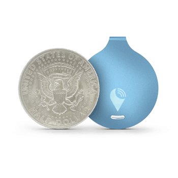
The TrackR easily attaches to valuable items that can then be located via an app using TrackR’s Distance Indicator or via Crowd GPS. Photo: Open Garden
The Open Garden Network makes it easy for devices to seamlessly access other devices and the Internet via secure peer-to-peer connections. Devices automatically detect nearby enabled smartphones or tablets via Bluetooth LE (Low Energy) and can pass data through them securely until the proper destination or recipient are reached. No pairing or configuration are required on the device owner’s part. To enable access to the network, device manufacturers use a simple digital access key, available from Open Garden and its partners.
TrackR, the first device to leverage the new technology, is a small, coin-sized device that attaches to valuable items such as keys, wallet, luggage, or bike. Using the TrackR app for iPhone and Android, a user can locate lost items in seconds. When an item goes missing, the device broadcasts a wireless signal. When another TrackR app user comes within 100 feet of the lost item, their phone sends a message to TrackR’s server with the updated GPS location of the item, and then the owner receives a GPS update on where the item is located.
With the Open Garden Network, TrackR users will also receive GPS updates when users of Open Garden’s apps or partners’ apps or devices come within the range. The system is completely secure and anonymous, the “finder” never knows they found anything.
“Open Garden provides an elegant solution to scale the TrackR community,” said Christian Johan Smith, TrackR’s President and co-founder. “We are excited to partner with Open Garden to expand our Crowd GPS network to deliver the best tracking experience.”
“With the 250,000 devices in the market, TrackR is one of the most successful IoT devices to date. IoT devices require connectivity and simplicity. Because the Open Garden Network is 100-percent software based, it scales infinitely and the costs are extremely low,” said Micha Benoliel, Open Garden’s CEO and co-founder. “Open Garden’s technology also enables operators to generate additional revenues while embracing the IoT revolution.”
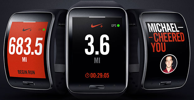
Samsung Electronics has unveiled its next-generation smart wearable device, the Samsung Gear S watch. The Gear S has assisted GPS+GLONASS, as well as 3G connectivity, allowing users to be active while always being able to access their smartphone information.
Designed with a two-inch curved Super AMOLED display and flexible band, the Samsung Gear S is also equipped with an accelerometer, a gyroscope, a compass, a heart rate monitor, and a barometer. The AMOLED display has an easy-to-use interface that allows users to read messages and notifications in a single glance with features such as conversation view and condensed font.
Connected to 3G networks, people can receive notifications from social networks, calendars and applications, even when away from their phones. Users can instantly receive incoming messages and easily reply to SMS using the onscreen keyboard or enhanced S voice functionality. The Samsung Gear S also lets users make and receive calls directly from their wrist as well as getting calls forwarded from a smartphone. The device lets users enjoy seamless communication by freely switching between connections, automatically connecting and synchronizing information once it is paired to a smartphone.
Samsung Gear S smart watch face detail. Photo: Samsung
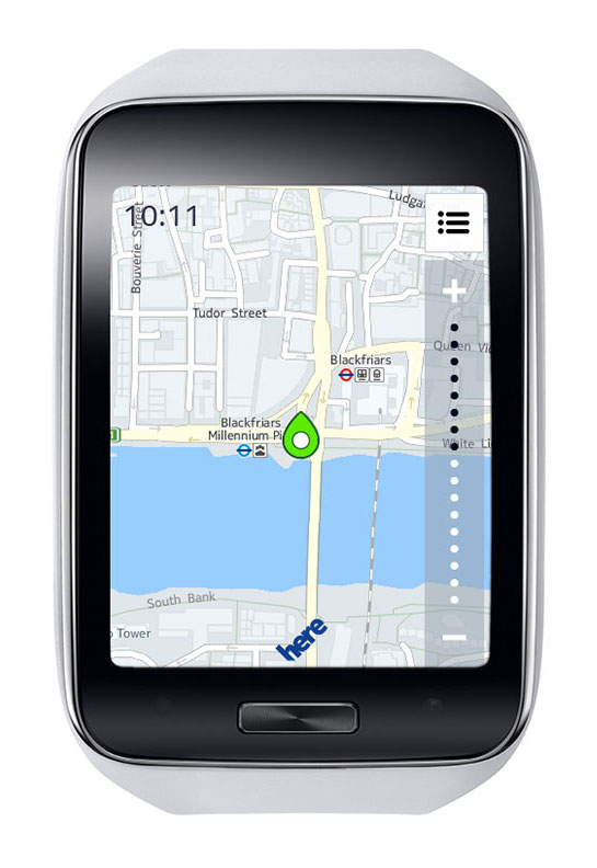
It also provides standalone features such as turn-by-turn pedestrian navigation provided by HERE. Health and fitness features include enhanced multi-sensors, built-in GPS, robust S Health features and applications like Nike+ Running so users can track their runs while leaving their smartphone at home.
“Samsung is leading the exciting and rapidly developing wearable category with continuous innovation that aims to enhance the lives of technology fans,” said Ines van Gennip, marketing director, IT & Mobile Division, Samsung UK & Ireland. “The Samsung Gear S is set to redefine the idea of the smart wearable device and the culture of mobile communication, enabling people to live a truly connected life anywhere, anytime.”
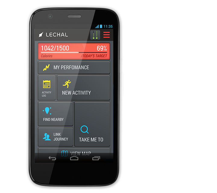
An Indian high-tech start-up is offering a GPS-enabled smart sports shoe that vibrates to give the wearer directions, according to an article in gulfnews.com.
The red sneakers count the number of steps taken, the distance traveled, and calories burned. The shoes go on sale this month under the name LeChal, which means “take me along” in Hindi.
The shoes come with a detachable Bluetooth transceiver that links to a Lechal smartphone app to direct the wearer using Google Maps, sending a vibrating signal to indicate a left or right turn.
They are the brainchild of 30-year-old Krispian Lawrence and Anirudh Sharma, 28, two engineers who founded their tech start-up Ducere in a small apartment in 2011 and now employ 50 people. They say they have 25,000 advance orders for the shoes, which will retail at between $100 and $150.
The Lechal app works with Google Maps. Photo: Lechal
Omnitracs, LLC, a provider of fleet management solutions to transportation and logistics companies, is making available Omnitracs Tracking powered by Roadnet, a mobile workforce tracking application for smart devices. Omnitracs Tracking offers basic capabilities to help companies track the locations of their mobile workers throughout the day and get additional performance data to help make them safer and more productive, the company said.
“Every transportation company with a mobile workforce wants to know the location and key behaviors of their drivers,” said Dan Speicher, chief technology officer at Omnitracs. “Omnitracs Tracking powered by Roadnet enables companies that have not adopted a fully featured mobile fleet management solution to utilize their existing smart devices in order to track locations of mobile workers, improving safety, productivity and customer satisfaction.”
Benefits of Omnitracs Tracking include:
Location Tracking. By leveraging existing smart device GPS positioning technology, location tracking pinpoints drivers’ locations in real-time using satellite and street maps. Fleet managers access this information through a web-based application, enabling them to provide customers with timely updates on the status of their delivery or service call.
Speed Tracking. The application monitors drivers’ speed throughout the day, allowing fleet managers to take prompt action to help preempt potential safety issues.
Exception Reporting. Users can predefine thresholds for maximum speed allowed, GPS gap, over road speed and stationary position time limits. Exception reporting helps to quickly identify driver behaviors that may lead to unsafe driving and reduced productivity.
“Omnitracs is committed to leveraging the expertise and capabilities of our business units to continuously bring value to our customers. Our newest basic tracking application will give companies the tools they need to better manage their mobile workforce and take fast, appropriate action to improve safety and productivity,” added Speicher.
Omnitracs Tracking is available exclusively through Roadnet and Omnitracs’ resellers. For more information about the application, visit.
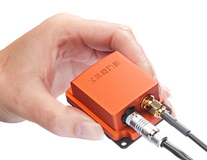
The MTi-G-700 by Xsens is a GPS-aided, IMU-enhanced GPS/INS that offers high-quality orientation and position. It makes use of sensory measurements from magnetometer, barometer, and a high-sensitivity GPS-L1 receiver to provide navigation estimates of position, velocity, and orientation at high data rates under high-dynamic conditions.
The Xsens estimation engine (XEE) sensor-fusion framework enables the motion tracker to take advantage of different aiding sensor measurements and optimally fuse them to get robust tracking estimates. The MTi-G-700 has a u-blox 6 internal 50-channel L1C/A code receiver with 2-meter horizontal accuracy and 5-meter vertical accuracy; SBAS; a 4-Hz update rate; 27-second cold start-up time; and -161 dBM tracking sensitivity.
The MTi is being used by customers for many maritime and oceanographic applications that require 3D orientation, 3D position, 3D velocity, and 3D dynamic data, such as a monitoring system in a barge master vessel where the MTi monitors the movement of a wave-compensated crane.
John All takes an ice sample from a glacier in the Ishinca Valley, Peru.
A climate scientist relies on a GPS satellite communicator to get him out of tight spots.
By Tracy Cozzens Photos by Clinton Lewis, Western Kentucky University
Please call Global Rescue.
John broken arm, ribs, internal bleeding.
Fell 70 ft crevasse.
Climbed out.
Himlung camp 2.
Please hurry.
That simple text message, sent May 19 via the DeLorme inReach communicator, alerted search-and-rescue monitors that the leader of a Himalayan research team was in dire straits.
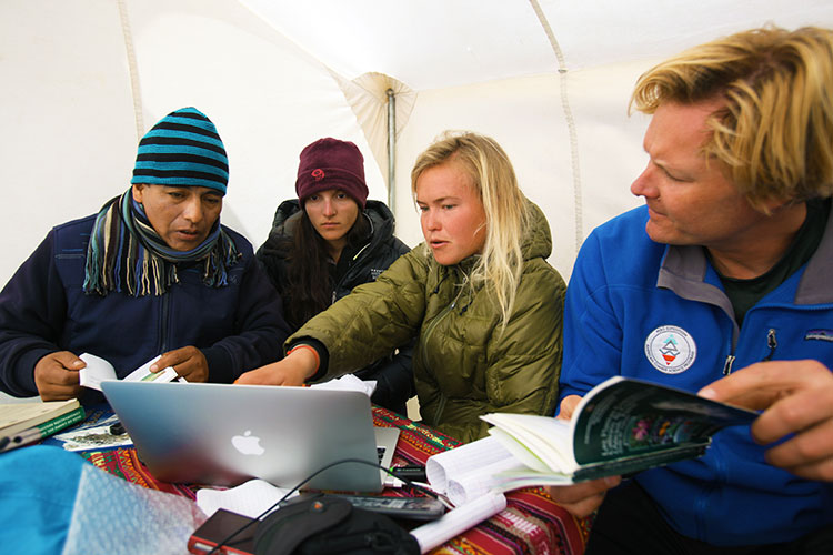
Dr. John All, director of the American Climber Science Program (ACSP), was leading a team collecting snow samples in the highest mountain range in the world to study the impacts of climate change when he tumbled into a crevasse. “After crawling back for hours to my tent, I sent texts via my sat messenger for help,” All told the local Kathmandu newspaper.
Friends and family of the expedition followed the rescue efforts every step of the way as text messages were sent via the InReach to the ACSP’s Facebook page.
The climate scientist was rescued via a helicopter and admitted to Norvic International Hospital in Kathmandu with five broken ribs, a dislocated shoulder, and internal bleeding. After a day in the ICU, he was discharged for a week of rest before returning for further care in the United States.
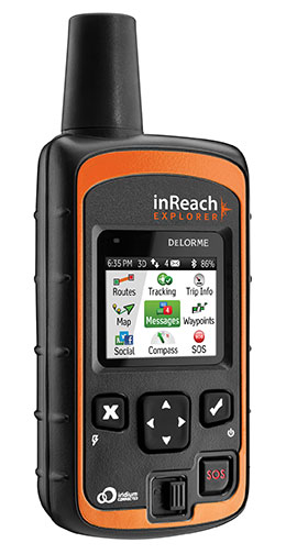
The DeLorme inReach Explorer.
In an emergency such as All experienced, the interactive SOS capability of the inReach automatically triggers remote tracking and allows users to communicate via text with responders at GEOS, DeLorme’s partner for international 24/7 search-and-rescue monitoring.
Going Out Again. All and his ACSP team departed for Huascaran National Park in Peru on June 23, just a month after his harrowing rescue in the Himalayas, for a two-month research expedition. All and several of his team members will be carrying the inReach devices.
Just like in the Himalayas, the inReach will give the team the ability to send and receive 160-character text messages from the remotest locations, provide location updates with GPS tracking, and keep them within reach of rescue with its SOS capabilities.
Besides providing peace of mind, the latest version of the inReach — the Explorer — allows the team to plan a route, mark waypoints, and create detailed track logs of their expedition.
“Knowing we would consistently be out of cell-phone range, we researched all satellite communication options to keep us connected,” All said. “A satellite phone was more than we really needed, and as a volunteer-driven non-profit program, it wasn’t very cost effective. We needed to be able to communicate back and forth in the event of an emergency, but we also wanted to keep everyone updated on the day-to-day status of the mission.”
Checking on the team’s status is as easy as visiting their Facebook page. Team members regularly post messages from anywhere in the world they might travel.
In Peru, the team of 20 students and scientists will examine changing climate conditions and the impact of human land use in the mountainous Cordillera Blanca region of the Andes, where Huascaran National Park is located. The park, a magnet for American climbers, has more than 33 peaks higher than 6,000 meters and hundreds of 5,000+ meter peaks. ACSP has been sampling snow in the region for the past three years in an effort to quantify the glacial contamination levels.
“Our work in Peru will be much more comprehensive than our high-elevation work in the Himalayas and will cover whole gamut of environmental parameters, from vegetation to water quality. The region is very remote and we will be collecting some samples from the walls of a crevasse to assess the seasonality of pollutants and their impact over time, so having an inReach with us is critical — both to communicate with each other and our team back home,” All said. Plus, he added, the students on his team will be able to communicate with their parents, providing their parents with peace of mind as their children travel to remote regions.
“Now that we’ve seen how well inReach works, we are looking forward to having more of them on this next trip — especially the newest Explorer model, which will allow us to mark waypoints during data collection,” All said.
In addition to the messaging, tracking and SOS capabilities, users of the company’s latest product inReach Explorer can view, create or navigate routes and waypoints. A map view displays routes, waypoints, tracks, and messages geo-located onscreen for backtracking or self-rescue. The built-in digital compass, barometric altimeter, and accelerometer sensors ensure accuracy and provide heading and bearing information, elevation readings, speed, and other useful trip statistics.
inReach communicates over the Iridium satellite network, providing global two-way satellite connections, high network reliability and low-latency data links (less than 60-second delivery of messages end-to-end) anywhere on Earth, with no gaps, fringe or weak signal areas. inReach has the ability to maintain a satellite signal lock even in difficult GPS environments, such as in a steep canyon or under a heavy forest canopy, DeLorme said.
The ACSP has visited Peru for climate research for three years, including in 2013 the Quillcayhuanca Valley (left) and the Ishinca Valley, places so remote that staying in touch can be a challenge. (Photos: Clinton Lewis/WKU)