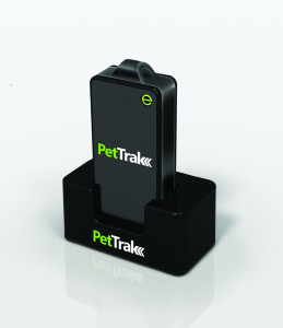
eTrak has announced the release of its latest product, the PetTrak GPS+ tracking system. Now available for purchase online, PetTrak is a small, lightweight device used to track the location of most pets.
PetTrak uses GPS+, eTrak’s patent-pending technology utilizing Wi-Fi, Cell ID, and GPS to deliver accurate location, indoors or out. Users will be able to utilize PetTrak to always know the location of their animal companions. PetTrak also allows users to set up specific safety circle zones, around designated areas where pets spend most of their time. If the pet leaves or enters this zone, the pet’s owner will be notified via text or email.
“One of the best features of PetTrak is the safety circle, which enables pet owners to draw a boundary circle around the house, yard, or any place that provides a protective perimeter for a pet,” said John Harris, eTrak founder and CEO. “If a pet wanders off beyond the circle, PetTrak will send an email and text message to the owner’s cellphone and computer. Not only that, but it will even include a Google map with the pet’s location.”
The PetTrak device can be attached to Simply attached to a pet’s collar. The animal can then be tracked in virtually any environment around the clock, from any smartphone, computer or tablet. With more than six million pets lost every year, PetTrak is designed to help owners rest assured knowing their furry friends are safe.
Placecast has launched PlaceAd to enable media buyers to target and reach mobile audiences based on their location. In addition to location, advertisers can target and optimize messaging across criteria including age, gender, interests, device type and operating system, time of day, and weather.
PlaceAd is a demand-side platform (DSP) built to maximize the value of location-based inventory on mobile. PlaceAd’s programmatic buying tools, analytics and included dynamic rich media engine are optimized for location-based campaigns. Placecast’s decision engine automatically optimizes campaign performance. PlaceAd can manage geotargeted campaigns based on the quality of the location data across billions of impressions with integrated reporting and store-level analytics.
Placecast is also announcing partnerships with some of the largest ad exchanges and supply side platforms (SSPs), including MoPub, PubMatic, and Smaato. With these key partnerships in place, Placecast can provide substantial reach for brands across thousands of mobile publishers and billions of monthly impressions.
“Mobile advertising, location and real-time bidding are the key ways to reach consumers today, and ad agencies can’t get enough of them,” says Karsten Weide of IDC. “PlaceAd is hitting a sweet-spot in the advertiser market and provides a timely solution for the pain points in reaching mobile audiences locally.”
Besides access to many different sources of ad inventory, media buyers also get comprehensive location-based reporting down to the most granular level, including heatmaps that provide a visual illustration of the intensity of impressions and engagement by targeted locations.
Key features of PlaceAd include:
Reach across thousands of safe mobile publishers for location-based mobile display inventory: Via partnerships with MoPub, PubMatic, and Smaato
Transparency on publishers where campaigns run
Real-time bidding: The ability to price and deliver on a per-impression basis in real-time; IAB OpenRTB 2.1 spec compliant
Machine Learning and Optimization: Placecast’s decision engine optimizes campaign performance based on activity across placements and publishers to maximize performance.
Dynamic Creative: Clients can change elements in the ad based on location, time of day, or other info on the consumer
Store-level analytics and reporting: Consolidated campaign reporting shows deliveries, clicks, and other actions across different inventory down to the individual store location. Heatmaps can be used to see campaign activity near targeted areas.
Geotargeting using both proximity geofencing and metro-level data.
Audience targeting though a number of methods:
Contextual targeting based on content
Place profiles
Third-party audience data
Third-Party Ad Serving Support: Agencies can track their campaign data in DoubleClick for Advertisers or Atlas
“PlaceAd is the latest addition in our toolset that makes it easier for advertisers and agencies to buy location-based mobile campaigns,” said Alistair Goodman of Placecast. “This new offering combines years of geofence marketing expertise with great tools and analytics that together reduce the friction in buying location-based mobile advertising campaigns at scale.”
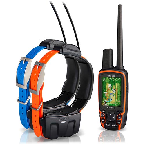
Garmin International Inc. now offers the DC 50 – a new and improved GPS dog tracking collar that’s even more robust and reliable than previous models.
“From more reliable satellite reception to a more rugged design, the new DC 50 gives sporting dog owners what they’ve been asking for,” said Dan Bartel, Garmin’s vice president of worldwide sales. “The new DC 50 has the features that will bring the benefits of GPS tracking to first-time users, and will convince existing Astro customers to upgrade.”
The DC 50’s main housing sits below the dog’s neck while a low-profile, high-sensitivity GPS antenna is now positioned atop the dog’s neck, providing a clearer view of satellites. In addition to tracking GPS satellites, the DC 50 can also utilize the GLONASS system. When using GLONASS satellites, acquisition time is (on average) approximately 20 percent faster than using GPS. And when using both GPS and GLONASS together, the receiver has the ability to lock on to 24 more satellites than when using GPS alone. In practical terms, that means sporting dog owners will spend less time waiting for the collar to acquire satellites before the hunt, and the collar will better maintain its location even in heavy cover and deep canyons during the hunt.
The Garmin Astro 320 GPS tracking device with two DC-50 collars.
The newly redesigned 22.5-inch long VHF antenna is made of braided steel that’s built to take any punishment that hard-charging dogs can deliver. Hunters can track their dogs up to nine miles in flat, unobstructed ground as often as every five seconds. A shorter 18.5-inch antenna is also included.
The battery life of the DC 50 has improved over previous generations, too. At a five second update rate, the DC 50 will get approximately 26 hours of battery life when fully charged. By slowing the update rate down to once every two minutes, the DC 50 collar can get up to 54 hours of use. As a safety feature, the DC 50 also has a selectable Dog Rescue mode, which automatically switches the DC 50 to a two minute update rate when the battery is less than 25 percent charged – making it easier to recover a lost dog.
For houndsmen, the DC 50 also features built-in Bark Detection, which alerts a hunter when their dog is barking frequently, even out of earshot. Users can customize the Bark Detection feature to adjust the frequency of barking and the manner in which the user is notified (visual, tone, vibration, or a combination of each).
The DC 50 features a standard one inch coated polyurethane collar strap that can be swapped out for a different color to easily distinguish between multiple dogs. The collar transmitter is waterproof to 10 meters (33 feet). Shipped alone, the DC 50 features a blue collar, and when purchased in conjunction with an Astro 320, the collar strap is orange.
When paired with the Astro 320, the system can track up to ten dogs per receiver at once, and will indicate the dog’s distance, direction, and status (sitting, running, pointing, or treeing). The Astro 320 features a full color, sunlight readable display with a pre-installed basemap. In addition to the pre-installed basemap, the Astro can be loaded with optional 100k Topo or 24k Topo maps or photorealistic BirdsEye Satellite Imagery. Many third-party specially-designed hunting maps are also available.
The DC 50 is compatible with Astro 320 handhelds that are currently in service, but users must download a free software update to their handheld before pairing the new collar, by visiting www.garmin.com/webupdater. The DC 50 is not compatible with the Astro 220 handheld or the Alpha Track and Train system.
Purchased alone, the DC 50 has a minimum retail price of $229.99, and the DC 50 bundled with the Astro 320 system has an MRP of $599.99.
GPSTrackit’s Fleet Manager Software now features an Analytics Dashboard that enables fleet managers to monitor and review fleet performance by reviewing historical data in a series of charts and graphs. Fleet Manager is a robust application providing fleet owners and managers with a comprehensive suite of integrated tools, GPSTrackIt said. The system delivers real-time GPS vehicle tracking, vehicle maintenance scheduling, and a wide range of alerts. The Analytics Dashboard brings to the system a new array of powerful and flexible capabilities.
“It puts the information fleet managers and owners need at their fingertips,” said Eddie Bermudez, GPSTrackIt’s product manager. “We already provide all the historical data via the reports system. This new feature brings that data to life with dynamic graphics.”
The dashboard displays up to six charts, which can be configured as bar charts or pie charts. Each chart can focus on particular issues important to fleet owners, managers and dispatchers: Idle Time, Drive Time, Stop Time, Speeding and Mileage.
“The charts can be configured to show data for all units or a single group,” explained Bermudez. “Or a chart can compare groups by displaying their data side-by-side using different colors.”
In addition, three composite charts are available; Engine Time, which monitors idle time and driving time; Driving Overview, which monitors idle time and driving time and stop time; Idle Stop, which monitors idle time and stop time. The time metric determines which historical data is used. Options available are week, month, quarter, and year.
“Charts can be rearranged on the dashboard by dragging and dropping,” added Bermudez. “And there are several additional options that can be configured. Chart labels of up to 25 characters can be added. The start of day can be set to any of the 24 hours. For bar charts, the average value can be shown superimposed on the graph.”
Bermudez continues, “The Analytics Dashboard can also display the highest or lowest values for a given graph. This can be configured to show values from one to 20. Selecting Highest and a numerical value of five on an Idle Time chart, for example, displays the five vehicles with the highest values for idle time.”
“This is important for fleet managers to know because of added fuel consumption, as well as vehicle wear,” according to Bermudez. ”Selecting Lowest and a numerical value of ten on a Speeding chart shows the ten vehicles with the lowest incidence of speeding.”
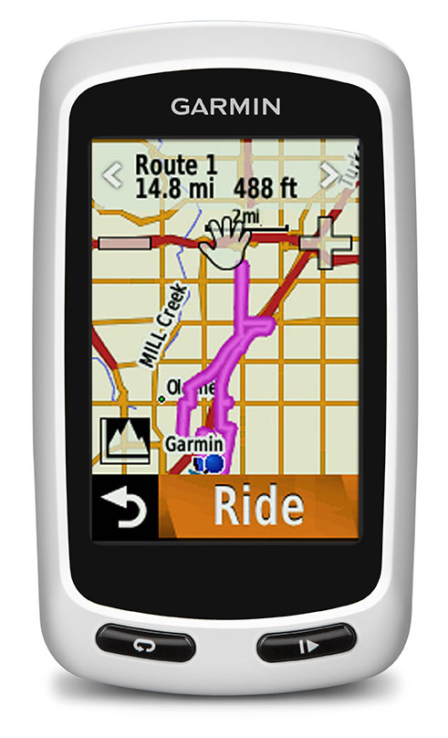
Garmin International Inc., a unit of Garmin Ltd., today announced the Edge Touring and Edge Touring Plus GPS navigators designed for touring cyclists, commuters, mountain bikers and those seeking navigation on their handle bars. Edge Touring and Edge Touring Plus work like a GPS navigator for a car, yet with bike-specific features, preloaded maps and points of interest to help cyclists to find their way. They provide both on-road and off-road navigation and can provide round-trip ride options based on a set distance.
The Edge Touring and Edge Touring Plus will debut at the Eurobike exhibition August 28-31 in Friedrichshafen, Germany (Hall A5, booth 201) and at Interbike in Las Vegas, Nevada (booth 11058), September 18-20, where they will be prominently displayed.
“The new Edge Touring and Edge Touring Plus are perfect for those whose bikes mean adventure, freedom, exploration and a way of life,” said Dan Bartel, Garmin vice president of worldwide sales. “Easy to set up, easy to use and preloaded with bike-specific maps, they will let riders navigate safely and securely to their destinations.”
Edge Touring comes preloaded with bike-specific maps that make it easy for cyclists to stay on the route and find their way back again. Whether cyclists are riding from A to B, asking Edge Touring to provide a round trip route, or following a ride that they have planned or downloaded from Garmin Connector Garmin Adventures, Edge Touring will guide them on their ride with clear turn-by-turn visual instructions. Cyclists can choose between Cycling, Tour Cycling and Mountain Bike modes to calculate the most appropriate route. Edge Touring will then guide cyclists on suitable roads or bike-paths to their destination. With the new round trip routing feature, cyclists need only to input the distance they want to ride and Edge Touring will do the rest. It will calculate up to three routes to choose from, including their distance and elevation profiles. Cyclists can compare the routes, choose the one to follow and are one tap of the screen away from turn-by-turn directions the entire way.
This Garmin video shows Edge Touring and Touring Plus in action:
Edge Touring is robust and water resistant and has a 2.6’-inch touchscreen that works in the wet and with gloves. It weighs less than 100g and fits on the stem or on the bars. The rechargeable battery will last up to 17 hours, and it is also compatible with optional solar external battery pack, which will give an additional 20 hours of ride time. Edge Touring displays key ride data such as time, speed, average speed, max speed, distance and much more. Cyclists can view from 1 to 10 fields on a clear customizable screen. Edge Touring comes with a quarter-turn bike mount and can be easily transferred between bikes.
Edge Touring records how far, how fast and where cyclists ride so users can replay, relive and share each ride in detail once it has been uploaded to Garmin Connect. Cyclists can share their own rides or search for ones others have completed in Garmin Connect or look for Adventures in Garmin’s free Basecampsoftware. Cyclists can also create custom courses within Garmin Connect and send them directly to their Edge Touring.
Edge Touring Plus provides all bike-specific features of Edge Touring, in addition to compatibility with ANT+heart rate monitors to help cyclists know how hard they are working, and will even display key data such as range or remaining charge from ANT+ compatible eBikes. It also includes a barometric altimeter for accurate elevation, gradient, ascent and descent data.
Edge Touring and Touring Plus are expected to ship fall 2013 and have a suggested retail price of $249.99 and $299.99 respectively.
Qualcomm Incorporated has signed a definitive agreement to sell its fleet management and tracking business Omnitracs to Vista Equity Partners for $800 million in cash.
The acquisition will include all of Omnitracs operations in the U.S., Canada and Latin America, including Sylectus and FleetRisk Advisors, which were acquired by Omnitracs in 2011. The transaction is expected to be completed during the first quarter of Qualcomm’s fiscal 2014.
Omintracs, formerly known as Qualcomm Enterprise Services, provides integrated fleet management applications, services and platforms to transportation and logistics companies. The company provides solutions for safety and compliance, driver retention, GPS fleet tracking, and fleet maintenance software.
“In the late 1980s, Qualcomm pioneered the use of commercial vehicle telematics with the introduction of the first mobile information system for transportation and logistics,” said Qualcomm executive vice president Derek Aberle. “As one of Qualcomm’s earliest businesses, Omintracs has maintained a leadership position within the industry for 25 years. Today, the opportunity for fleet management and telematics is evolving rapidly, and we believe Omnitracs is well positioned to continue its leadership position as a stand-alone entity.”
“We are long-term investors in enterprise software, data and technology-enabled businesses that are committed to being leaders in their fields,” said Robert Smith, chief executive officer and founder of Vista Equity Partners. “We are impressed with the compelling value proposition Omnitracs’ products and services offer their customers. We look forward to working with them and helping them to reach their full potential.”
The closing of the transaction is conditioned upon, among other things, clearance under the Hart-Scott-Rodino Antitrust Improvements Act of 1976 and other customary closing conditions.
Mobile resource management has never been a sexy market full of buzz and excitement — we are talking tracking trailers and containers. However, it is on pace to see double-digit growth through 2020. Led by a handful of companies in local fleet, long haul, cellular and trailer tracking, MRM has never faced ups and downs like other location market segments. In fact, acquisitions and growth appear to be in the future for this market segment.
With more than 5.7 million tracking units nationwide, and 9 million more expected to be sold by 2015, the mobile resource management market continues to be one of the steadiest, and profitable, location businesses.
In one of the bigger MRM deals earlier this month, Danaher Corp. purchased Garden City, California-based Teletrac, which was owned by Vector Capital. Teletrac, which offers a cloud-based software as a service (SaaS), has units installed in more than 200,000 vehicles in 87 countries.
In terms of segments within MRM, the local fleet market continues to be the largest, according to Clem Driscoll, president of CJ Driscoll and Associates, who is completing a multi-client study of U.S. fleet operators that is sponsored by two major wireless carriers. Local fleet operators had more than 3 million units installed in 2012. In 2000, local fleet companies had about 250,000 units installed, according to Driscoll.
Another growing MRM market segment include cell-phone-based systems with 1 million units. Long-haul trucking and trailer tracking both have less than 1 million units installed in 2012. The major players in long-haul trucking markets have included Qualcomm, PeopleNet and XRS (Xata), but Qualcomm just announced that it is selling its fleet management and tracking business Omnitracs to Vista Equity Partners for $800 million in cash.
Driscoll says the largest GPS fleet management company is Fleetmatics, which recently went public, raising $94.3 million. The company has 331,000 units installed worldwide, and had $127.5 million in revenue last year.
Driscoll has identified several MRM trends: hardware prices are declining, MRM service providers are bundling the hardware; leveling off of equipment purchases for local fleet markets as suppliers transition to third-generation devices; increased integration with Android; smartphones and tablets; and more acquisitions.
Speaking of acquisitions, the past year was a busy one for MRM. Telogis bought Maptuit and NavTrak. CalAmp bought Wireless Matrix, which is a GPS-cellular tracking company.
For long-haul trucking acquisitions, the biggest deals came from Trimble, which purchased TMW Systems, ALK Technologies and GEOTrac, an oil and gas monitoring company.
In Europe, the United Kingdom and France could see growth, but Spain has economic problems. Germany still is a strong long haul market, Driscoll says. In Asia, there should be 9 million potential units sold in the next few years, with China being the dominant player. Korea and Japan are maturing markets.
Overall, by 2020, MRM could achieve the same level of penetration as the smartphone market. Today’s smartphone may be the ultimate telematics equipment, and future MRM equipment of choice, as the automotive OEMs have found out by listening to their consumers, Driscoll said.
Google Maps Already Using Waze
In other location industry news, Google Maps this week is using Waze real-time traffic reports on its app for Apple iOS and Android, according to a blog post from Google. The announcement constitutes the first significant use of the Waze app since Google purchased the Israeli startup for $1 billion in June.
While Google Maps users will be able to use reports about accidents, construction and road closures, Waze consumers will be able to get access to Google search and Street View. According to published reports, more than 15,000 new map editors joined the Waze editing community this month, which is a 43 percent month-over-month increase.
Intel Shuts Down Telmap
Late last month, after our LBS Insider deadline, Intel announced it was shutting down Telmap, an Israel-based company it acquired in 2011 for a reported $120 million. The move signals the end of Intel’s navigation business, which had hoped to offer end-user tools and white label technology for developers.
Telmap employed 150 people at its development center in Herzliya, Israel, and had dozens of other employees at various Intel branches throughout Europe and the United States. Telmap rolled out a free navigation app called M8, which was launched earlier this year. The app drew revenue from advertising and was marketed to wireless carriers for rebranding.
In Israel, Orange, Cellcom and Pelephone, the country’s largest wireless carriers, all use Telmap’s white-labeled product, according to published reports.
According to published reports, some of the Telmap employees will be placed in other positions within Intel Israel. The reports said that Intel was too late with its free app and was way behind crowdsourced traffic providers such as Waze.
Telmap, founded in 2000, was viewed as an up-and-coming player in the location industry. It supported wireless carriers mainly outside of the United States such as Orange FT Group, SingTel, MTS, Vodafone, Vodacom, SFR, Telefonica-02 and others. Its U.S. partners included Nokia (Navteq), MapQuest and Inrix.
Is the Location Industry Conference Dead?
After working overseas for nearly a year, I have noticed that there are not a lot of industry events to cover, particularly pure location conferences. There may be a connected vehicle panel at the Consumer Electronics Show or a CTIA trade show.
However, the location-centric conference appears to have died in the wake of industry consolidation (and Google’s giving navigation away for free). Replacing these conferences are connected vehicle and insurance telematics conferences that feature an occasional wireless, or LBS, panel.
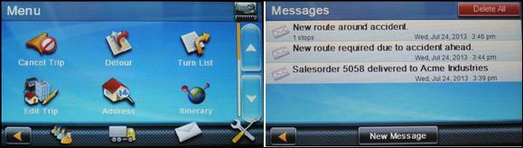
iTRAK Corporation, a provider of GPS-based wireless fleet tracking, has integrated the patented iTRAK Fleet Executive (iFE) cloud-based software, the iTRAK WebApp software for tablets and smartphones, and iTRAK’s wireless GPS tracking equipment with the Magellan RoadMate Commercial 5190T-LM fleet navigation unit. The combined product will allow remote tracking of vehicles and handsets in the field, while integrating with the Magellan commercial product to provide in-cab navigation voice prompts and terminal text messaging.
The new product, combined with a heavy duty engine interface, will meet the new and emerging EOBR/ELD standards, while providing customers with the flexibility, efficiency and reduced liability required by today’s professional carriers and heavy duty equipment operators.
“Magellan is pleased to have iTRAK as a partner integrating the Magellan RoadMate Commercial 5190T-LM in their offer combining navigation, messaging and fleet tracking,” said Mark Perini, associate vice president of Product Marketing for Magellan.
The combined system provides fleet tracking using iTRAK’s patented iTRAK Fleet Executive (iFE) and iTRAK WebApp to remotely track vehicles and handsets in the field, while integrating with the Magellan RoadMate Commercial 5190T-LM commercial product to provide in-cab voice navigation and terminal messaging through the iFE cloud-based application. Features include:
Five-inch WVGA touch screen.
Customizable truck routes.
The truck road attributes can be turned off, so drivers can use the same navigation device in their personal passenger vehicles.
Free lifetime traffic alerts.
Multiple stop routing.
Hours of service tracking.
Optional engine interface: Both OBD-II and J1939 interfaces are supported. Engine data can be transmitted to the office by the iTRAK system.
Loud (93-dB) speaker.
Messaging to and from the vehicle.
Truck-specific POIs such as weigh stations and truck stops.
Bluetooth: The navigation device includes Bluetooth capability, to pair with and serve as the speaker for a smartphone.
Ability to phase implementation: The system is modular so it can be implemented in stages to help drivers adjust to the new technology
The combined product will provide affordable and safe fleet tracking, communication and navigation functions for commercial trucking, service vehicles, government, sales fleets and much more.
For more information contact iTRAK at 719-686-0100, or e-mail [email protected].
GTX Corp, which specializes in putting GPS technology in consumer products, and Atlantic Footcare have signed a manufacturing and distribution agreement to develop and launch GPS embedded insoles. Under the agreement, Atlantic Footcare will be making an investment of $200,000 to advance the development of the new GPS SmartSoles.
Atlantic Footcare, headquartered in Rhode Island, has been a designer and manufacturer of insoles for more than twenty years and supplies many of the major athletic and shoe companies, national retail chains, and the U.S military with high-quality and comfort insoles. Atlantic Footcare has experience in embedding electronics inside insoles through other partnerships and alliances and has completed the first prototypes of the GPS SmartSoles, which are undergoing testing.
“This relationship and investment with GTX is a great opportunity to couple technology with an insole, enabling us to produce a truly innovative and cost effective solution to meet today’s growing personal tracking needs. We are very excited at the opportunity to be at the forefront of wearable GPS tracking technology,” said Charlie Sipes, Atlantic Footcare president.
GTX Corp had been researching ways to further miniaturize its GPS module to penetrate new markets and expand current ones. “Compared to our existing module, this next gen is approximately 30 percent smaller, thinner, and lighter; 20 percent less expensive; and has 200 percent more battery life. It is equipped with a motion sensor and advanced A-GPS technology for pinpoint accuracy and rapid time to first fix,” said GTX Corp CEO Patrick Bertagna. “The opportunity to partner with Atlantic Footcare opened up and with this latest next generation device, embedding the module inside an insole was a natural next step.”
Rocky Mountain Tracking has added new GPS tracking devices that utilize CDMA cellular data networks in addition to its existing GSM-based devices.
CDMA coverage has steadily grown within North America during the last decade and is sometimes available in places where GSM networks don’t currently provide coverage. “Adding support for CDMA based devices allows us to offer our customers a choice of cellular provider based on their operational needs,” said Brad Borst, the company’s president.
“We’ve worked with our existing manufacturing and cellular service partners with the goal of being able to let our customers mix and match GSM and CDMA based devices into their fleet tracking strategy. The new CDMA devices look the same and function almost identically to their GSM counterparts,” says Borst. “CDMA devices will appeal to our customers operating in more remote locations within the United States while GSM continues to be a good option in metro areas and abroad.”
Rocky Mountain Tracking is a national GPS tracking device supplier and service provider.
INTRUSION SENSORS strive to have a high detection rate and low false alarm rate.
By Eric Olson and Steven Pisciotta
Ongoing threats from terrorist activities at critical facilities require early detection before the threats can reach their target and complete their mission. This has produced the need for advanced security systems to effectively detect terrorist activity, while reducing alarms caused by normal friendly activity. Automatic Threat Assessment, also referred to as Identify Friend or Foe (IFF), is the ability to automatically acknowledge alarms created by friendly assets. It can be achieved with a security system that uses GPS and geospatial data to go beyond the typical intrusion-sensor-only configuration.
The addition of a tracking system associated with friendly vehicles and personnel can provide the missing information necessary to tighten security and reduce the need to take action on alarms caused by friendly targets, and reduce the material and personnel cost of threat assessment. Tracking systems and intrusion sensors can worktogether to automatically classify an actual intruder with high confidence and without operator intervention.
The Verification Problem
Typical intrusion sensors include intelligent fences, ground proximity sensors, radar, LIDAR, and video analytics. The role of the intrusion sensor is to identify a breach and notify security personnel so they may perform verification. Table 1 shows the formal alarm types received from intrusion sensors, which strive for a high detection rate and a low false-alarm rate. For this reason, the nuisance alarm can be problematic as it reflects a real event for the intrusion sensor, but often a non-event for the security operator.
These typical sensors only provide a “suspected intruder” list. The follow-on task is to decide whether or not to reclassify a suspected intruder as an actual intruder. This process is typically a manual task and can be difficult, confusing, and time-consuming.
For instance, a landscape crew will trigger alarms. Even for very accurate systems that can uniquely track the object over a long period, it is highly likely that over the period of time the landscapers are in the area, the track will be lost, causing the system to re-alarm on the same person or vehicle, as it represents a potential intrusion.
If the landscaping crew needs to open a gate, and that gate is integrated into the facility’s access control system via a dry contact or beam breaker device, it may continuously alarm while left open, or at a minimum, in the case of the beam, each time one of the workers or the vehicle passes through the entrance. In these situations, security will either need to validate each alarm by verifying it on a camera or having an officer follow the landscaping crew throughout their route.
The existence of a friendly alarm event that needs continual validation can lead to compacency of security personnel, either not verifying it, or not verifying it in a timely manner.
Table 1. Alarm types.
Combined Detection, Location
A GPS tracking system combined with the intrusion sensors can help identify friends. Tracking systems consist of two main types of locating devices: GPS-enabled devices and wireless transponders.
Modern, low-cost GPS receivers can achieve an accuracy rating of less than 3 meters, provide an update once per second, and do not require visibility to the open sky. Wireless communication transmits the GPS data to the C2 system. A typical data set includes time, date, latitude, longitude, altitude, heading, speed, and quality of GPS signal.
The combination of intrusion sensors and tracking systems can produce automatic threat assessment. Routine situations requiring significant security involvement, such as the landscaping scenario, can be automatically managed by the system. The command and control system has the ability to know friendly targets and their location.
Further, the system can perform a check before actually alarming. In the case of a perimeter alarm, it now has the intelligence to understand, within a level of confidence, that the object detected by the intrusion sensors is the same friendly item being tracking by the tracking system. If the system determines the targets to be the same object, the alarm can be suppressed, eliminating the need for security to verify the event.
THE COMBINATION of intrusion sensors and a tracking system allows for Automatic Threat Detection.
Common Operating Picture
The integration of these types of systems is not complex in terms of how to coordinate data. Interface documents exist for these types of integration and are done on a regular basis. Typical position and target information is communicated over XML in a standard format. However, to gain these benefits, the tracking systems and intrusion sensors must all work within a common geospatial operating picture.
Advantages of geospatial or geo-referenced systems systems include the ability to easily display and control data in a map-based format, allowing tracking systems and intrusion sensors to synergistically perform automatic verification. This combined knowledge of the target’s track also allows the fusing of the GPS data and the intrusion sensor data into a single object and path, aiding security by reducing target and track clutter on his command and control or PSIM (perimeter security information system).
Take for example a guard enabled with a tracking device, performing a tour around a fence protected by video analytics enabled cameras. On a typical PSIM, a normal guard tour would result in two icons on the display, one friendly from the tracking system and one unknown from the video analytics. This scenario would also result in two similar object tracks. Security would need to review the situation and understand that this symbology represents a single target and a single track.
Integrating the tracking system with the video analytics system allows for a fusing of this data, and the resulting command-and-control symbology is a single target and a single track.
Other considerations when combining a tracking system with intrusion sensors include update rate, time and location accuracies, and overlapping coverage.
Ideally, all sensors would be synchronized when it comes to timing aspects, but this is typically not the case. Different timing between data updates and time inaccuracies can result in the inability for the systems to confidently conclude that two tracks were created by the same target. Transport delay, the transmission of the GPS data through the satellite, can also be an issue. For tracking devices, it’s vital for the data to be received by the C2 system with a repeatable transport delay. Variability in the transport delay also decreases the ability to automatically verify the threat.
Geographic accuracy of both the GPS tracker and the intrusion sensor is another important factor in data fusion. Typical GPS trackers have an accuracy rating of 3–10 meters. Actual accuracy varies based upon the visible GPS satellites, tall buildings, body worn, and RF interference. Intrusion sensors also possess an inherent accuracy. Radar surveillance may have a resolution of 1 x 1 meter at close range, but it expands at far range to 1 x 20 meters.
Intelligent fence sensors and video analytic systems can have resolutions that vary from 1 to 25 meters, based on the type of sensor and the terrain. These geographic inaccuracies can be handled to some degree by considering other factors, including heading, speed, and previous track, but it’s important to understand where these inaccuracies can occur.
Overlapping coverage of surveillance sensors also affects data fusion. In the case of track fusion, this ability is only available is areas where both a geospatial intrusion sensor exists and a tracking system is operational. If there are gaps in overlapping coverage, or areas that do not include geospatial- based intrusion sensors, then fusion is not possible in those regions.
Eric Olson is vice president of Marketing at PureTech Systems.
Steven Pisciotta is president of Remote Tracking Systems.
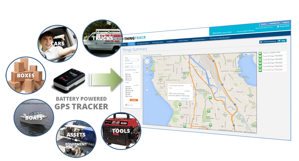
SeeControl is announcing the roll out of ThingTracr, a hosted SaaS GPS tool for monitoring anything that needs to be tracked. The simple-to-use solution offers precise location tracking and historical analytics reporting for things of interest using a small and attachable GPS unit that requires no tools or wiring. The tracking service can be up and running in less than five minutes.
Using web browsers or mobile devices, a user can easily monitor the status of the tracked asset. It can be used for cars, trucks, trailers, packages, site equipment or anything else.
“There are several unique features that set ThingTracr apart from other tracking services,” said Bryan Kester, CEO of SeeControl. “One is a modifiable modern dashboard that allows users to personalize how they view the tracking information in the most convenient way for them. Another is the ability to upgrade and expand to new GPS trackers globally as they come on the market.”
Other features of ThingTracr include:
90-day location history
User customizable dashboards
Low battery alarms
Satellite / hybrid map views
Multiple reports
Data export – CSV/ PDF
Trip Reports
Range of pre-certified hardware
Trip replays on maps
ThingTracr uses various battery-powered GPS devices, which can also notify users of several alarms including motion detected, speeding, and information regarding battery life.
The ThingTracr GPS tracking tool is just one of many vertical solutions available from SeeControl M2M ( Machine 2 Machine ) cloud platform. The ThingTracr solution is available through SeeControl partners including M2M distributors, Network Operators and Systems Integrators.