An Australian company is proposing putting GPS tracking devices in footballs as early as 2015, according to a report by News Corp Australia. Both the National Rugby League (NRL) and the Australian Football League (AFL) are considering using the trackers in footballs as early as next year. The AFL and several National Football League (NFL) teams in the United States already use trackers for player monitoring.
The battery-operated devices, the size of a 10-cent coin, are made by Melbourne-based company Catapult. The devices have the capacity to influence score decisions and analytics, Catapult said. They can track the ball’s speed and time held in possession by a player, and help provide deeper analysis of the game. Spectators also would get a glimpse, with more details of the game made available to them.
Catapult already manufactures and sells GPS devices worn by players in various sports including the AFL, and also makes indoor stadium tracking systems for athletes and elite sports teams. The NRL is aware of the technology, but has not yet decided to implement it.
For the current football season, this year the NFL began using RFID chips for in-game player tracking at 17 stadiums, just over half. The RFID chips, manufactured by MotionWorks, allow the NFL to measure player orientation and capture location information, which is then shared with fans. The data is also used by broadcasters to show plays.
A quarter of NFL teams and 10 major U.S. college programs are using GPS trackers, mostly for training and injury prevention.
“The number one goal of this system right now is trying to help prevent injury as well as help us with the rehab process. There are a lot of different things that goes in to it, but the biggest thing is ‘how can we monitor guys on the field to help us get the information’?” said Eric Ciano, strength and conditioning coordinator of the Buffalo Bills.
“I think us being able to manage practice and how we do it with the GPS system, how we train with that thing year-round, [has] allowed us to take a lot of the guesswork out of how tired your team is, where your pulls, your tears are,” said Jimbo Fisher, head coach of Florida State University football. “Our soft tissue injuries are down 88 percent in the last two years because we’ve been able to apply that. And we use it full-time to gain that information. It’s on my desk, the first thing when we walk in every day.”
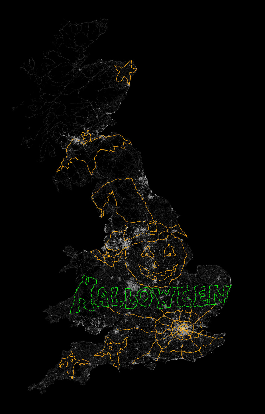
In October, Jeremy Wood drove all over the United Kingdom to create a Halloween message, reports Metro. Wood drove a 10,000-mile, painstakingly-plotted route through England, Wales and Scotland in a Vauxhall Corsa, plotting a 264,000 positions on the car’s GPS. Wood linked the positions on a virtual drawing to create a picture that shows bats, ghosts, a spider web, and a pumpkin in a witch’s hat, with the word “Halloween” underneath. The result is the image below.
Photo: VB
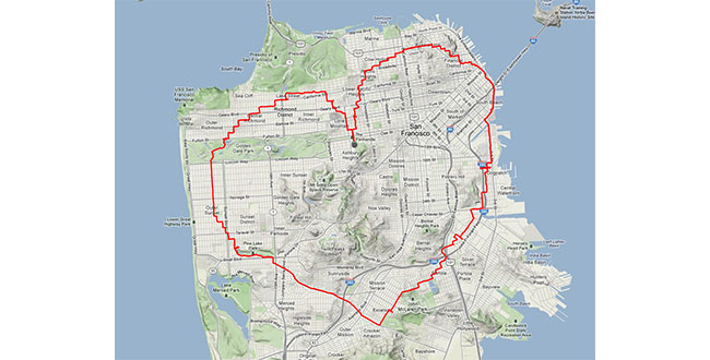
Wood isn’t the first GPS-inclined artist. In 2013, a man in San Francisco equipped with an iPhone and tracking app rode his bike 27 miles around the city. Two and a half hours later, Payam Rajabi had etched a heart shape onto a city map.
Photo: VB
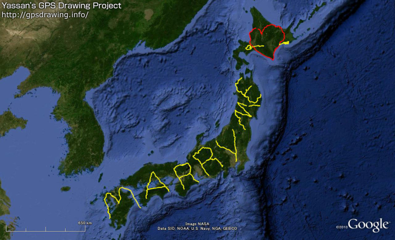
But the biggest devotee of GPS art could be Japanense artist Yassan, who in 2010 left behind his girlfriend for six months to travel across Japan, reports VB News. Carrying a GPS device, Yassan covered 7,163.7 km mostly by walking, but with some use of a car, ferry, and bicycle. He then used Google Maps to connect the GPS points he visited, resulting in this unique marriage proposal:
Photo: VB
Though he made the journey four years ago, his trek is now being featured in a new ad campaign and documentary by Hi-Tec, a company that makes hiking shoes and boots.
Yassan has been creating large-scale GPS drawings for years. Yassan was so inspired by the possibilities of GPS art that he quit his job in June 2008 to pursue his passion for making GPS drawings. Learn more about Yassan’s GPS Drawing Project on his website.
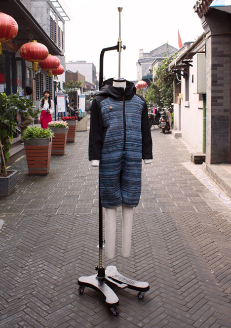
Dutch textile company ByBorre and its founder, fashion designer Borre Akkersdijk, have created the BB.suit — a wearable Wi-Fi hotspot with GPS, a music library, and an air purifier.
Version 1.0 of the suit, which has electrical threads woven into the fabric, was showcased at the SXSW music and film tradeshow in March, where a model’s location was shown on Google Maps, allowing anyone to locate the suit using its GPS data, and then upload songs to a 22Tracks platform.
Version 2.0 introduces an additional tech — an air purification system. Demonstrated at Beijing Design Week in September, the garment purifies the polluted air surrounding the wearer. According to Dezeen, designers Akkersdijk and Eva de Laat collaborated with Martijn ten Bhomer from the Eindhoven University of Technology, Daan Spangenberg Graphics, and StudioFriso to create the one-piece suit, which looks like an adult onesie.
“The BB.Suit started because everyone was talking about wearable technology, the bracelets, the glasses,” Akkersdijk told Dezeen. “We thought about how we could really integrate the electrical threads and sensors and not just stick them on.”
The electrical yarns are woven into the body and legs of the outfit, while the long sleeves and a hood are made from standard textiles. The air-quality sensor at chest level is connected to a hidden platform chip that tracks and transmits data counting the particles of carbon monoxide, methane and dust around the body. The chip is wired to a battery and a cold plasma node on the back of the suit.
You won’t be able to outfit yourself with the garment yet, as it was created as a step towards a connected wearable platform rather than a product to be marketed.
GPS World’s December cover story, “The Fashion Demands of Always-On,” discusses the chip architecture requirements of wearables. Read it here.
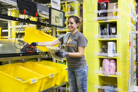
An Amazon employee picks items in the company’s newest generation fulfillment center. (Photo: Business Wire)
It used to be when you expected a home delivery, you could specify morning or afternoon, and hope you were there when the truck showed up. In today’s high-tech retail experience, van deliveries can be slotted specifically in two hour, or even one hour, windows. This is just one development in the battle for speed, as major retailers turn to technology to help Santa get presents under the tree on time.
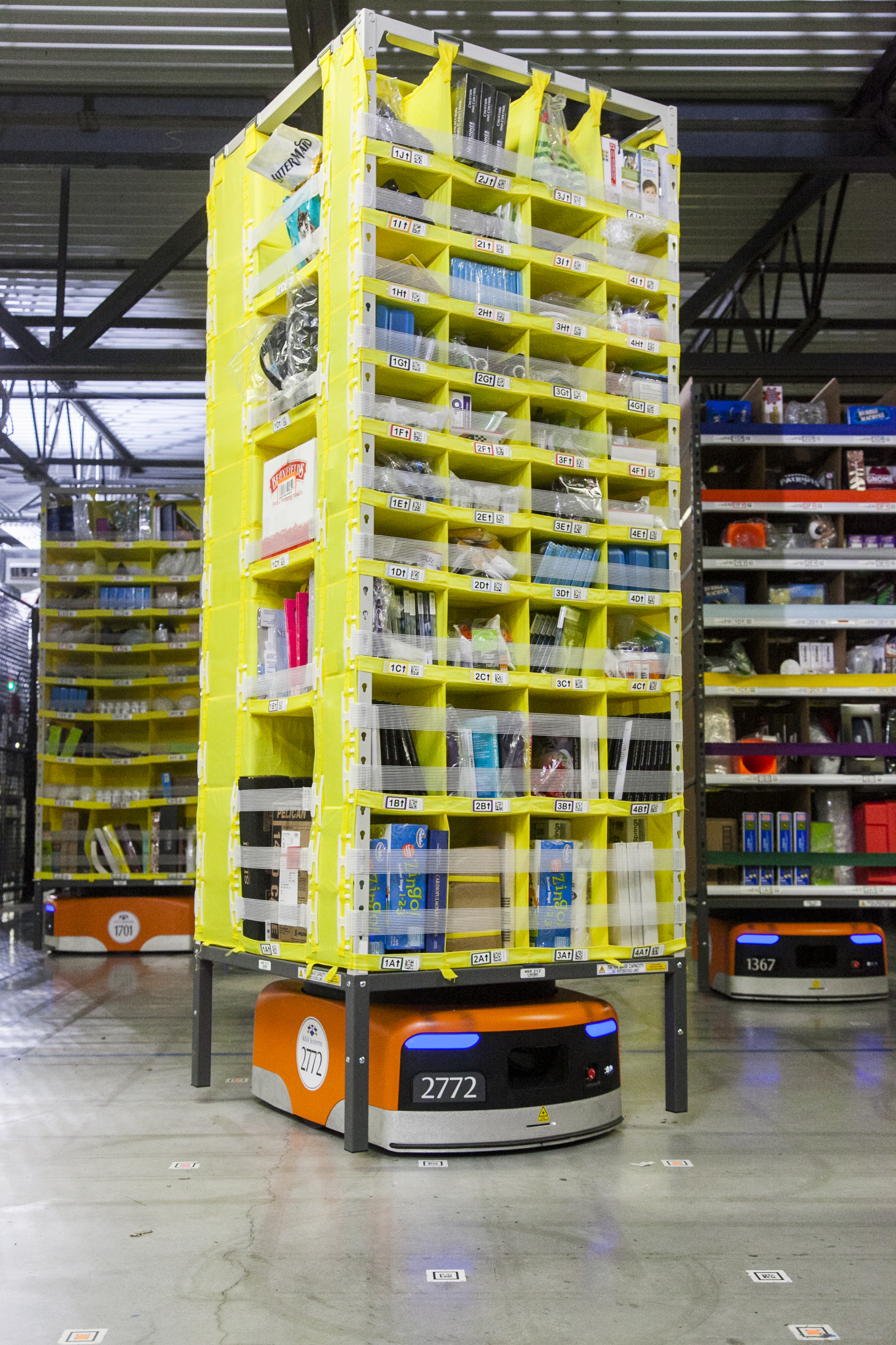
According to a feature at BBC News, automated route planning and GPS tracking of vans has greatly improved deliveries, along with better warehouse scanning technology, such as the intricate robotic system employed by Amazon in its warehouses.
A Kiva robot moves product in Amazon’s eighth generation fulfillment center. (Photo: Business Wire)
The system uses robotics, Kiva technology, vision systems and almost 20 years’ worth of software and mechanical innovations to fulfill holiday orders. Amazon purchased the system in 2012 and tested it in 2013, but this is its first year for full deployment. Instead of having employees go to the shelves to find the items for an order, robots automatically deliver the items to them, hauling seven-foot-tall shelving units on their backs.
The robotic system has made picking products go two to three times faster, employees said.
The need for speed presents is a huge challenge for retailers trying to offer their customers a seamless shopping experience in-store, online and via mobile, the BBC reports. “Speed is the new battleground,” said Craig Sears-Black, UK managing director of Manhattan Associates, a software company specializing in warehouse management systems. “These days orders have to be processed in two hours, not two days. The physical side of selling needs to be optimized.”
In the UK, MetaPack handles the delivery of online transactions for 80 of the UK’s top 100 retailers, integrating about 240 delivery companies worldwide into its system. “These days competition amongst carriers is giving consumers a lot more choice over when and where their parcels are delivered,” said Patrick Wall, MetaPack founder and chief executive.
When a customer selects delivery options, MetaPack works out which are available in which location for which goods. MetaPack then decides which carrier represents best value for the retailer and handles all the tracking data so everyone can know exactly where the parcel is on its journey at any time.
In the U.S., FedEx is using enhanced visibility technology to help customers plan for package deliveries and pickups. At many FedEx ground facilities, high-speed six-sided camera tunnels with real-time package tracking updates scan every side of a package, enhancing the readability of a shipping label and providing visibility to a package’s location at all times.
That tracking technology, coupled with network-wide improvements, will offer customers increased visibility this season, including clarification as to exactly when a package is available for pickup at FedEx locations, FedEx said. It also will offer increased visibility into a package’s journey, from the time FedEx takes possession of the package to its estimated delivery date.
GTX Corp, a personal location wearables company, has entered a strategic partnership with Life Button 24, a division of World Wide Security Group and provider of life safety, dispatch and monitoring services since 1979.
Under the strategic partnership, GTX Corp will offer Life Button 24 services to its GPS SmartSole customers, providing 24/7 access to live dispatch operators that can assist caregivers when a loved one goes missing. The premium service will be offered through GTX on a monthly subscription basis as an add-on to existing monthly tracking service plans provided by GTX.
“Our GPS SmartSoles were specifically designed for caregivers to be able to react in real time to find a loved one who has wandered off,” commented Andrew Duncan, director of GTX Corp. “By partnering with Life Button 24, we will now offer our U.S. customers an enhanced level of service and extra layer of protection. The service will be able to provide a caregiver with the ability to contact a live person, who can assist in coordinating the successful search and rescue of the loved one, or assist in notifying the proper authorities if needed. By offering this service, we enable individual caregivers and assisted living staff, among others, with an additional level of 24/7 human response, when critical support is most needed.”
“Life Button 24 is thrilled to provide 24-hour emergency response services in partnership with the GTX Corp SmartSole GPS system,” said Jeff Katz, director of project development for Life Button 24. “Addressing wandering issues of individuals afflicted with Alzheimer’s and autism is a growing concern for the millions of families and caregivers. Life Button 24 looks forward to being part of a greater solution that delivers peace-of-mind through advanced tracking technology and customized emergency response services, which were designed specifically to support applications such as the GPS SmartSole.”
“With initial delivery dates for our GPS SmartSoles to consumers being confirmed next week and several pilot agreements with large organizations kicking off this month, the timing of this partnership with Life Button 24 couldn’t be better. “After several months of integrating and testing our platform and services and having socialized this new offering with some of our larger partners in law enforcement and the assisted living community, we are extremely excited to start offering this service and look forward to a successful partnership with the Life Button 24 team.” Commented Patrick Bertagna CEO of GTX Corp.
Ultra-Low-Power, High-Accuracy Location for Wearable GNSS Devices: From Host-Based to On-Chip
Photo: Steve Malkos, Manuel del Castillo, and Steve Mole, Broadcom Inc., GNSS Business Unit
As location penetrates smaller and smaller devices that lack memory and computation power, GNSS chips must reacquire the standalone capability that they shed when first going to small form factors such as phones. A new chip with a new architecture demonstrates navigation and tracking and avoids burdening its main processor with heavy software.
By Steve Malkos, Manuel del Castillo, and Steve Mole, Broadcom Inc., GNSS Business Unit
End users first experienced the amazing capabilities of GPS 12 years ago with early mass-market GPS devices. The focus was on navigation applications with specific tracking devices like personal navigation devices and personal digital assistants (PNDs, PDAs). With the advent of smartphones, GPS became a must-have feature. Other constellations were added to improve performance: GLONASS, QZSS, SBAS, and very recently, BeiDou. In the current phase, the focus is shifting to fitness applications and background location. This is not an insignificant change.
Always-on connected applications, high-resolution displays, and other such features do not improve battery life. This article describes new ultra-low-power, high-accuracy location solutions for wearables’ power consumption.
Impact of Always-On Connected Applications
New applications require frequent GNSS updates with regard to user position. Sometimes the application will be open and other times it will not. The chips need to keep working in the background, buffering information and taking predefined actions. The GNSS chips need to be able to cope with these new requirements in a smart way, so that battery life is not impacted. Saving power is now the name of the game.
Furthermore, GNSS is penetrating small devices: the Internet of Things (IoT) and wearables. They do not have the luxury of large resources (memory, computation power) as smartphones do. GNSS chips cannot leverage the resources in those devices; they need to be as standalone as possible. In summary, the new scenario demands chips that:
do not load device’s main processor with heavy software;
use less power while maintaining accuracy;
can be flexibly configured for non-navigation applications.
New GNSS Chip Architectures
The industry is designing chips to meet these requirements by including the following features:
measurement engine (ME) and positioning engine (PE) hosted on the chip;
accelerometer and other sensors directly managed by the chip;
new flexible configurations, duty cycling intervals, GNSS measurement intervals, batching, and so on.
These features require hardware and software architectural changes. The new chips need more RAM than that required for smartphones, as they must now host the ME and PE. Wearables and IoT devices are small, cheap, and power-efficient. They do not have large processors and spare memory to run large software drivers for the GNSS chip. In many cases, the device’s microcontroller unit (MCU) is designed to go into sleep mode if not required, that is, during background applications. Therefore, new GNSS chips with more RAM are much better adapted to this new scenario.
New chips must tightly integrate with sensors. The accelerometer provides extremely valuable information for the position update. It can detect motion, steps, motion patterns, gestures, and more. However, as a general rule, the MCU’s involvement in positioning should be minimized to reduce power consumption. For power efficiency, the new GNSS chips must interface directly with the sensors and host the sensor drivers and the sensor software.
Finally, new chips must adapt to different human activities as they are integrated into wearable devices. This is the opposite approach from past developments where GNSS development was focused on one use case: car navigation. Now they must adapt to walking, running, cycling, trekking, swimming, and so on. All these activities have their particularities that can determine different modes in which new GNSS chips can work. Electronics must now conform to humans instead of the other way around. New wearable-chip GNSS tracking strategies include dynamic duty cycling and buffering, which contribute to the goal of reducing power consumption without compromising accuracy.
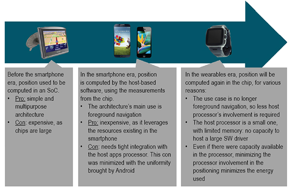
Satellite positioning embedded in devices over the last few years first saw on-chip positioning before the era of smartphones, where you had dedicated SoCs that supported the silicon used to compute the GNSS fix. These expensive chips had lots of processing power and lots of memory. Once GNSS started to be integrated into cellphones, these expensive chips did not make sense. GNSS processing could be offloaded from the expensive SoCs, and part of the GNSS processing was moved onto the smartphone application processor directly.
Since navigation is a foreground type of application, the host-based model was, and is still, a very good fit. But with advances in wearable devices, on-chip positioning will become the new architecture. This is because the host processor is small with very limited resources on wearables; and because energy must be minimized in wearables, reducing the processor involvement when computing GNSS fixes is critical.
Some vendors are taking old stand-alone chips designed for PNDs and repurposing them for wearable devices. This approach is not efficient, as these chips are large, expensive, and use a lot of power.
GNSS Accuracy
While the new fitness and background applications in wearables have forced changes in GNSS chips’ hardware and software architectures, GNSS accuracy cannot be compromised. Customers are used to the accuracy of GNSS; there’s no going backwards in performance in exchange for lower power consumption.
Figure 1. Software architecture for wearables.
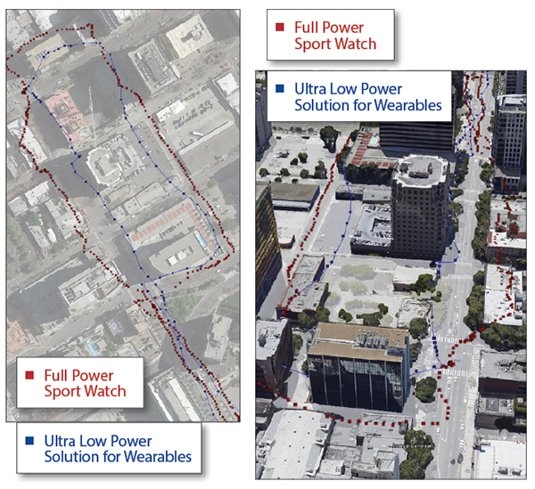
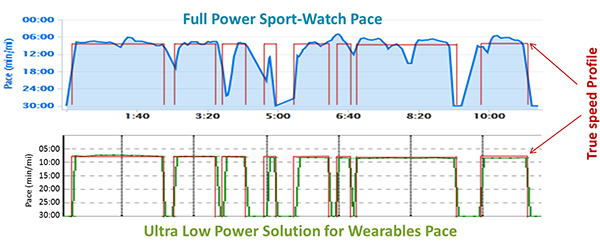
A series of tests shown here demonstrate how a new wearable, ultra-low-power GNSS chip produces a comparable GNSS track to existing devices using repurposed full-power sportwatch chips, while using only a fraction of the power.
Speed Accuracy. Not only does the ultra-low-power solution produce a comparable GNSS track, it actually outperforms existing solutions when it comes to speed and distance, thanks to close integration with sensors and dynamic power saving features (Figures 2 and 3).
Figure 2. Ultra-low-power versus full power.Figure 3. Full-power sportwatch, left, and ultra-low power chip, right, in more accuracy testing.
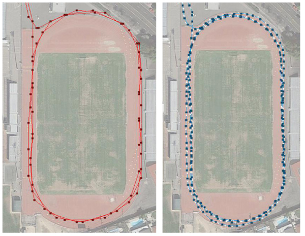
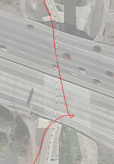
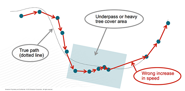
GNSS Reacquisition. GNSS-only wearable devices face a design challenge: to provide complete coverage and to avoid outliers. This is seen most clearly when the user runs or walks under an overpass (Figure 4). Familiar to urban joggers everywhere, the underpass allows the user to cross a busy road without needing to check for traffic, but requires the GNSS to reacquire the signals on the tunnel exit. See the GNSS track in Figure 5: when the device reacquires the signals, the position and speed accuracy suffers.
Figure 4. Position accuracy on reacquisition, emerging from overpass.Figure 5. GNSS speed accuracy on reacquisition.
Using the filtered GNSS and sensors, however (Figure 6), enables smooth tracking of speed and distance through the disturbance.
Figure 6. Sensors provide smooth speed estimate.
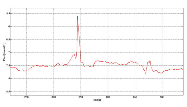
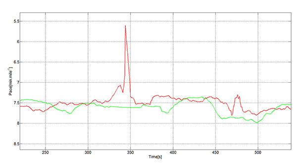
Urban Multipath. The pace analysis in Figure 7 shows a user instructed to run at a constant 8-minute/mile pace, stopping to cross the street where necessary. The red line on each plot shows the true pace profile. The commercial GNSS-only sportwatch on top shows frequent multipath artifacts, missing some of the stops and, worse for a runner, incorrectly showing erroneously high pace. The ultra-low-power chip captures all the stops and shows a constant running pace when not stopped.
Figure 7. Urban multipath tests.
It is well known in the community that regular sportwatches give unreliable speed and distance estimates in urban environments — where most organized running races are held! There’s nothing worse, as a runner, than to hear the distance beep from your watch going off earlier than expected: how demoralizing! The major benefit of this solution is that the speed estimate is much more reliable in the presence of multipath. At the same time, battery life can be extended because the GNSS is configured to use significantly less power.
fSpeed in existing solutions is computed in two different ways: indirectly from two consecutive, time-stamped GNSS position estimates, each derived from range measurements to the satellites, and directly from the Doppler frequency offset measurements to the satellites. Both range and frequency measurements are subject to significant error when the direct path to the satellite is blocked and a reflection is acquired.
The effects of multipath mean that the range error may in typical urban environments be hundreds of meters. The frequency error is also a function of the local geometry and is typically constrained by the magnitude of the user’s horizontal speed.
In either case, the GNSS device alone, in the presence of signal multipath, generates a velocity vector that fluctuates significantly, especially when there is a change in the satellites used or signal propagation path between the two consecutive positions. A variety of real-life cases generate this sudden fluctuation in velocity vector:
Running along a street in an urban canyon and turning a 90-degree corner.
Running along a pedestrian lane and taking a short road underpass.
Running under tree cover and suddenly arriving at an open area.
Running under an elevated highway and turning 90 degrees to a wide-open area.
In each case, the chips are using a certain set of satellites, and suddenly other, higher signal-strength satellites become available. A typical situation is for the position to be lagging the true position (while under tree cover, going through an underpass) and needing to catch up with the true position when arriving to the wide-open area. A jump in position is inevitable in that situation. This is not too bad for the GNSS track, but it will mean a noticeable peak in the speed values that is not accurate. Fitness applications save all of the computed speed values and generate a report for each workout. These reports are not accurate, especially the maximum speed values, for the reasons explained above.
Figure 8 describes a typical situation where the actual speed of the runner is approximately constant. GNSS fixes are computed regularly; however, the speed computed from subsequent GNSS fixes have sudden peaks that spoil the workout speed reports.
Figure 8. Sudden peaks spoil workout speed reports.
The new ultra-low-power solutions for wearables solve this problem by deriving speed and accumulated distance from the sensors running in the device. This avoids incorrect speed peaks, while still being responsive to true pace changes by the runner.
In running biomechanics, runners increase pace by increasing step cadence and/or increasing step length. Both methods depend on the runner’s training condition, technique, biomechanics, and so on. As a general rule, both step cadence and step length increase as the running speed increases from a jogging speed to a 1,500-meter race speed.
A runner may use one mechanism more than the other, depending on the moment or on the slope (uphill or downhill). In the case of male runners, the ratio of step length to height at a jogging speed is ~60 percent.The ratio of step length to height in a 1,500 meter race speed is ~100 percent. For female runners, the respective ratios are ~55 percent and ~90 percent.
The ultra-low-power chips take into account both mechanisms to derive the speed values. The sensor algorithms count the number of steps every time interval and translates the number of steps into distance multiplying by the step length. The reaction time of the GNSS chip to speed changes based on a higher cadence is immediate.
Speed changes due to longer steps are also measured by the ultra-low-power chips. The step length is constantly calibrated by the GNSS fixes when the estimated GNSS position error is low. The reaction time of the GNSS chip to speed changes based on longer steps has some delay, as it depends on the estimated error of the GNSS fixes.
Manufacturer
The ultra-low-power, high-accuracy, 40-nanometer single-die BCM4771 chip was designed by Broadcom Corporation. It is now being manufactured in production volumes and is focused on the wearables and IoT markets.It consumes five times less power than conventional GNSS chips (~10 mW) and needs 30 KBytes of memory in the MCU for the software driver. It features tight integration with the accelerometer and innovative GNSS tracking techniques for extremely accurate speed, accumulated distance, and GNSS tracking data.
Steve Malkos is an associate director of program management in the GPS Business Unit at Broadcom, responsible for defining GPS sensor hub and indoor positioning features. He has a B.S. in computer science from Purdue University, and currently holds eight patents,10 more pending, in location.
Manuel del Castillo is an associate director of marketing for Broadcom in the GNSS group. He has an MS in electronic engineering from the Polytechnic Universityand an MBA from the Instituto de Empresa, both in Madrid, Spain. He holds three patents in location with five more pending.
Steve Mole is a manager of software engineering for Broadcom in the GNSS group. He received his bachelor’s degree in physics and astrophysics from the University of Manchester.
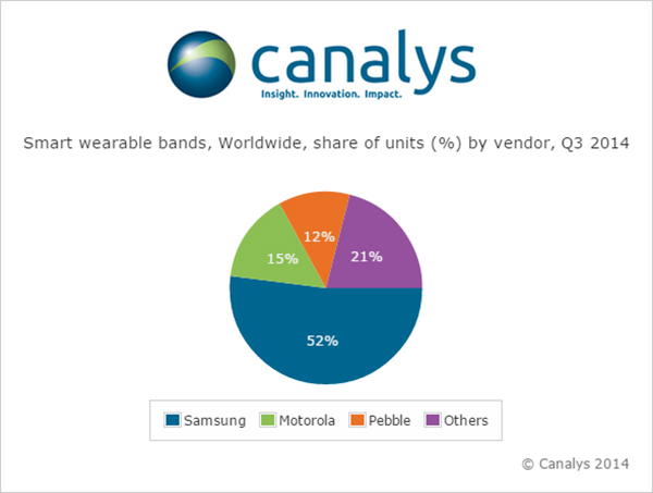
Nearly 5 million smart and basic wearable bands shipped in Q3 2014, with total unit shipments increasing 37% quarter on quarter as Android Wear made its mark for the first time, according to a report by independent analyst company Canalys.
Motorola Mobility’s Moto 360 was by far the most successful of the initial Android Wear devices, accounting for more than 15% of the smart band market according to Canalys estimates. Despite being supply-constrained, its appealing design helped it to easily out-ship other Android Wear products.
LG has responded to early interest in the Moto 360 by quickly adopting a circular display with the G Watch R.
Meanwhile, Samsung remained the overall smart band market leader, and the company has already begun to experiment with larger display sizes and cellular connectivity with the Gear S, its sixth smart band.
Though the platform is still young, Android Wear will be fundamental to the development of the market, as it is poised to be one of the two dominant wearable operating systems outside of China, alongside Apple’s Watch OS. But Google will need to redesign the Android Wear user interface before the platform can achieve its true potential.
‘The announcement of the Apple Watch late in the quarter has likely had an effect on sales of existing devices, as some consumers will choose to wait for Apple’s wearable,’ said Canalys Analyst Daniel Matte. ‘The smart band market was flat between Q2 and Q3, but with an installed base of over 1.8 billion Android smart phones, there is a huge potential market of Android users not considering an Apple Watch.”
Fitbit and Jawbone held onto their first and second place positions, respectively, in the basic band market for the quarter, and both have just announced new products. Garmin passed Nike to take third place in shipments, while Xiaomi and Huawei also overtook the one-time market leader and rounded out the top five. “Low-end basic bands providing simple activity tracking functionality are becoming increasingly commoditized, and will flood the market heading into the holidays, especially in China,” said Canalys Analyst Jingwen Wang. ‘To combat this, Fitbit, Jawbone and others have attempted to make basic bands smarter, adding various smart watch features and increasing the sophistication and integration of sensors.’
Google Fit, Microsoft Health and the Samsung Digital Health Platform have all recently been announced in response to Apple’s HealthKit. While the new Microsoft Band does not have strong hardware appeal, Microsoft’s cross-platform cloud services approach is a wise strategy, and the company is importantly staking its relevance early in a new market. There is tremendous opportunity for brand new services on wearable platforms, and not just in the area of health and fitness. Expect developers to eagerly embrace Apple’s WatchKit SDK, expected to be released in early 2015.
Wearable band shipment data is taken from Canalys’ Wearable Technology Analysis service, which provides quarterly market tracking, including country-level estimates. Canalys defines basic wearable bands as devices serving a specific set of purposes that act as accessories to smart devices, are designed to be worn on the body and not carried, and that cannot run third-party computing applications. Smart wearable bands are multi-purpose devices that serve as accessories to smart devices, are designed to be worn on the body and not carried, and are capable of running third-party computing applications. Bands are wearables designed to be wrapped around the body and do not include activity trackers in the form of clips.
Telefónica and Geotab have announced an agreement to partner in Europe. The agreement will initially focus on the markets of Spain, Germany and the U.K., with the intention to explore Latin American markets in the near future.
The solution, which includes Geotab’s plug-and-play device, offers real time fleet management and the ability to develop a number of alerts, notifications, and review driver trip and activity reports. Advanced features also include on-board diagnostics through engine indicators to return feedback, such as engine failures, or an in-depth engine fault code diagnosis; detect accidents and retrace cause of the accident; and allow add-ons such as a navigational device, NFC driver ID key, sensors and more.
According to Geotab, the technology will help businesses improve their on-road productivity, on-road safety, and ecological efficiency, in addition to optimizing fleet performance to reduce fuel costs. Fleet managers will gain more intelligence across multiple vehicles giving them the data and insights needed to make more informed business decisions in real-time. Furthermore, drivers will have more insight over their individual vehicles.
Through this agreement, Telefónica extends its fleet management offer to further cover the global needs for its clients of both large corporations and small and medium size companies.
“We’re delighted to partner with Geotab, who through continuous innovation have many of the world’s largest fleets already using their product,” said Surya Mendonça the m2m managing director at Telefonica. “This agreement allows Telefónica to provide a best-in-class ‘plug and play’ fleet telematics product in Europe that reinforces our portfolio and gives our m2m customers further access to the strongest solutions.”
“We are seeing tremendous growth for fleet management solutions worldwide and the wireless carriers are now becoming an integral component of the fleet telematics and connected machine ecosystem. We are impressed by the Telefonica m2mteam and look forward to working together with Telefonica to deliver the most advanced fleet telematics solution in the market,” said Neil Cawse, CEO of Geotab.
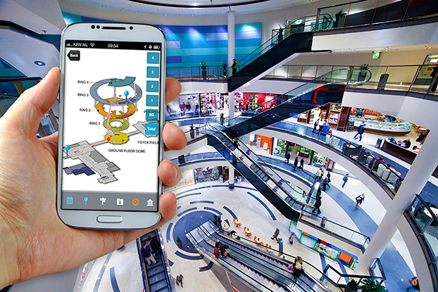
CSR plc today announced the launch of its SiRFusion Software Development Kit (SDK) for Android application developers. The solution enables indoor positioning for Android developers looking to create next-generation apps.
Developers can now leverage the SiRFusion library to rapidly integrate new location-based capabilities and services such as indoor location tagging and analytics for social networking applications, indoor navigation, lone worker efficiency and safety capabilities, as well as indoor asset tracking and targeted e-commerce services.
CSR is being acquired by Qualcomm, with the transaction expected to close by the end of the summer of 2015.
Mobile applications with integrated SiRFusion can now deliver the ubiquity of outdoor navigation to indoor environments without costly surveys or infrastructure upgrades. SiRFusion combines real-time Wi-Fi signals, satellite positioning information, pedestrian dead reckoning, and the company’s cloud-based CSR Positioning Center to calculate accurate indoor location. SiRFusion technology provides the accurate indoor position fixes needed to make continuous indoor navigation a part of everyday life. The system automatically crowd-sources a venue’s indoor Wi-Fi signatures as consumers walk through the location, and it has also been architected to accommodate future proximity and location technologies such as Bluetooth Smart beacons, Wi-Fi Round Trip Time (RTT), and Indoor Messaging System (IMES).
“Offering indoor positioning accurate enough to be useful has been a challenge that the industry has been trying to solve for many years,” said Anthony Murray, Senior Vice President, Business Group at CSR. “But with consumers coming to expect anytime-anywhere positioning wherever they are, our customers have continued to express a growing interest for accurate indoor positioning without the need for additional infrastructure. With our SiRFusion Software Development Kit, we have, for the first time, made indoor location a reality for developers who want to deliver innovative location-based products and services without proprietary infrastructure.”
SiRFusion for Android can be integrated into any app running on Android version 4.4 or later. The SDK will be available for download from www.csr.com in Q1 2015, and will include the SiRFusion library, API descriptions, and a Developer’s Guide. CSR will demonstrate SiRFusion for Android at the Location and Context World conference December 2-3, held at the JW Marriott in San Francisco, and at Consumer Electronics Show (CES) in Las Vegas January 6-9, 2015. To schedule a private briefing and demo at either event, contact [email protected]
Location-based services company Telenav has announced new capabilities and updates to its free Scout mobile application that make the process of connecting and getting together easy and fun. Scout users can now manage the details of creating an event, contacting and inviting friends, choosing a location, communicating with the group and navigating, all within the updated Scout application. Scout is powered by OpenStreetMap.
For iOS devices, the new app experience will offer predictive, intuitive traffic push notifications for users’ everyday trips, eliminating the need to manually check for traffic delays. The newest version of Scout is now available from Google Play for Android and iTunes for iOS.
The results of a new survey from Telenav underscore the common pain points of planning events, meet-ups and meetings for consumers — especially Millennials — which Telenav is aiming to help alleviate with the updated Scout app. Nearly half (49 percent) of Millennials reported that they would find it useful to have a single solution that enables them to plan an event, communicate with attendees while they’re en route, and see each other’s estimated time of arrival.
“Mobile users have come to expect more out of their navigation devices and applications,” said Rohan Chandran, president and general manager of Telenav’s mobile division. “Navigation alone is critical, but it is a commoditized utility. We are looking to embrace the things that people really care about — the experiences in real life for which you navigate. Getting together should not be hard work, and we are trying to solve that. Scout is the new way people connect, get together, and go places in real life. It’s the only app that takes you all the way from chatting, to making event plans, to getting together in person, complete with voice-guided GPS along the way and everyone’s whereabouts and ETA pinpointed on the map.”
Scout’s new in-application features include:
Socialized Navigation Experience. In addition to offering invitees voice-guided, turn-by-turn directions to the event destination, Scout offers real-time location and ETA insights so guests are able to view the positioning of other guests on the navigation map. This prevents a barrage of “Where are you?” texts and calls while en route — and eliminates questions about where directionally challenged or perpetually tardy friends are.
Easier Meet-Up Invitations. Scout replaces what typically requires multiple applications by conveniently taking care of all the details of getting together, from inviting guests on their contact lists, to picking a day, time and location. “Did I get an invite?” and “what time is the event taking place?” are the last questions that organizers will be asked.
Group Chat. For the friend who is always left out, Scout users can now chat with all of the other event attendees directly within the app, allowing them to avoid juggling multiple text and phone conversations, and easily adjust and discuss the details of an event.
Predictive, Personalized Traffic Reports (iOS Devices Only). Users can schedule traffic report updates informing them of road conditions for their regular drives, and recommended alternate routes.
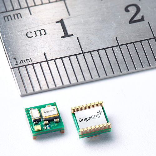
OriginGPS has launched the Nano Spider, a tiny yet fully integrated GPS receiver. The Nano Spider module is designed to support ultra-compact applications where size is at a premium, such as smart watches, wearable devices, trackers and digital cameras.
OriginGPS, which previously introduced the Micro Spider (5.6 x 5.6 mm) module, said the Nano Spider is 47 percent smaller than its previous solutions, measuring 4 x 4 x 2.1 mm. The Nano Spider’s proprietary structure is a multi-level circuit for surface mounting, built to reduce footprint size.
“The wearable technology trend requires components that balance a small size with high-performance and best-in-class power consumption,” said Gal Jacobi, CEO of OriginGPS. “OriginGPS aims to continue to shrink the size of components, while increasing features to make adding location functionality possible for every device.”
OriginGPS’ Nano Spider continuously tracks all GPS satellites in view and provides real-time positioning data in the standard industry format defined by the U.S. National Marine Electronics Association (NMEA). The Nano Spider offers a complete System in Package (SiP) that includes:
Fully integrated features – The Nano Spider includes a low noise amplifier (LNA), surface acoustic wave (SAW) filter, temperature controlled crystal oscillator (TCXO) and real-time clock (RTC) crystal, a power management unit, and radio frequency (RF) shielding.
Superior sensitivity and performance – The Nano Spider module offers accuracy of approximately one meter, and achieves a rapid time to first fix of less than one second and tracking sensitivity of -163 dBm.
Continuous connectivity with minimal power consumption – It achieves a state of near continuous availability by detecting changes in context, temperature and satellite signals by maintaining and opportunistically updating its internal fine time, frequency, and satellite data, while consuming microwatts of battery power.
Improving marginal signal conditions – It includes OriginGPS’ proprietary Noise Free Zone (NFZ) system to increase noise immunity even under marginal signal conditions, such as urban canyons, under dense foliage or a rapidly changing receiver position.
To see a demo of the Nano Spider and Nano Hornet modules, visit OriginGPS’ booth (Hall A4 Booth 271) at Electronica 2014 in Munich, Germany.
KCS BV has launched a new tiny tracker, the TM-202LAR. It’s the newest addition to the KCS family of TraceME products. The KCS GPRS/GPS range of modules enable users to remotely track and trace people, animals and a variety of objects, such as vehicles, containers, motorcycles, lawn mowers, or other valuable assets.
KCS TraceME TM-202LAR is targeted for personal use, or any other application that needs a small size with long battery life while still featuring the options and server connection that full-size units have.
The TraceME TM-202LAR is KCS’s smallest full featured GPS tracker at 46 x 21 x 6.5 mm, weighing 7 grams. Other features and options include:
GPS, RF and GSM antennas
advanced power saving, down to 2.5µA
10 years of operation from one Lithium C-Cell
RF connectivity, up to 2 km
location-based positioning (LBS/Wi-fi/GPS)
onboard sensors for compass, temperature, acceleration