US Fleet Tracking‘s GPS trackers allow companies to monitor its fleet drivers’ speeds.
Monitoring a driver’s speed may reduce the risk of an increase in insurance premiums, ticket costs, and fuel and maintenance costs. The company’s GPS trackers store speeding information, meaning drivers may increase performance knowing their speed is being observed.
A decade’s progress: on the left, the 2004 AXTracker. On the right, the 2014 GTO.
Over a decade ago GPS World covered the introduction of the first battery-powered asset tracking device that operated over satellite networks, the AXTracker (“Going the Distance,” October 2003). More than ten years later, the technology has proven the market, and opened new markets. Battery powered tracking devices today are used for the expected, like enterprise asset tracking for trailers, containers, and field equipment, to the unexpected like tracking sea currents, ranging sheep, and weather balloons.
The newest products are dramatically smaller, have much longer battery life, and pack accelerometers and Bluetooth for mobile phone connectivity and wireless sensor interface. Yet power management, cellular and satellite communications, and environmental ruggedness remain the technical challenge.
Battery Technology. Advances have occurred in rechargeable technologies, largely driven by cellular telephones, military and automotive, but advances in primary batteries for industrial use are limited. Environmental operation is the problem. It remains extremely difficult to produce a primary cell that retains power for a decade while exposed to industrial temperature extremes. Global GPS tags for industrial use must operate in industrial temperature ranges of -40 C to + 85 C (-40 to + 185 F) while limiting self-discharge to enable operation over many years. Primary cells providing utility over the industrial temperature range with low self-discharge rates remain the same as available ten years ago.LiMnO2 (lithium/manganese dioxide) and Li-SOCl2 (lithium-thionyl chloride) are still the leading chemistries.
Lessons learned from field deployments have produced quality improvements and better field longevity and yield. Not all AA batteries with the same paper specifications survive equally, so developers must be wary. Through power reductions in satellite communications and GPS technology discussed below, the asset tag of today can enjoy a volumetric and cost reduction for batteries while achieving the same service duration.
GSatellite Network Technology
Ten years ago, the available global commercial satellite machine-to-machine (data) networks included Iridium, Orbcomm, INMARSAT and Globalstar. Though several of the satellite network service providers are replacing retired satellites, the technology remains unchanged and developers are left with the same choices today as ten years ago. Each satellite network offers different strengths and weaknesses for specific M2M field applications with different power budgets required. The AXTracker of a decade ago utilized the Globasltar simplex capability specifically because of the power budget profile for data delivery. From a satellite network power perspective, the limitations of one-way (field to cloud) satellite solutions employed by that first tracker continue to out-weigh other satellite network offerings.
In order to utilize the available satellite networks, the asset tag must integrate satellite communication circuitry. In a world of continuous technology improvements, the satellite transceiver evolution has been slow. Over the past decade most of the major satellite network providers have next-generation transceivers. However, the new technology has only marginally improved the power issues for battery-powered industrial GPS tags. For example, Iridium’s first OEM transceiver, the 9601, required peak power of 7.5W, with average power of 1.8W. Their latest transceiver, the 9603, is much smaller physically but still requires the same 7.5W peak, though average power is now 1W. Average power for an Iridium data packet delivery is the measure of the power used over message transmit and receive as well as idle times while accessing the satellite network. This average power for Iridium is the parameter used for calculating message delivery per a given battery capacity but peak power must also be supplied in any design that seeks to use the data service. Orbcomm and INMARSAT technology have similar power budgets due to their communications handshake requirements to access the network. For these systems, it remains difficult to source this power capacity and peak current requirements at -40C environmental temperature using batteries only.
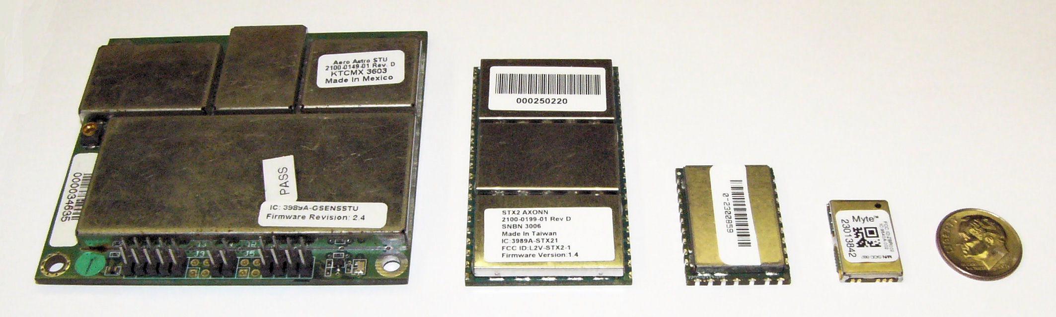
(From left) STX1, STX2. STX3, MYTE.
Similar power improvements are available in the Globalstar simplex system. The Globalstar system is different than the other commercial M2M satellite networks in that data is merely transmitted one-way from the GPS tag to the network, thus removing the power needs for handshaking with the network to deliver data. The STX1 radio transmitter of eleven years ago required a whopping 6W during transmit, but thankfully was soon replaced with the STX2 radio transmitter. The STX2 is still the primary simplex transmitter in use today and requires 1.65W during the one-way short-packet bursts. The much lower and short duration requirements for power were, and are, the deciding factor for network selection for the original battery operated GPS tag. Today, the Geoforce MYTE radio transmitter embedded in the GT1 and GT0 devices requires 1.1W peak, an 82% reduction from the short-lived STX1 and a 33% reduction from the STX2. For simplex service, the peak power is used to calculate message delivery per available battery capacity since there are no network access or receive power requirements. Ten years of simplex transmitter evolution and size reduction enable fundamentally smaller asset tags while providing a 30% to 40% reduction in power required for satellite data delivery.
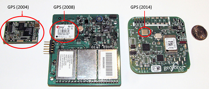
GPS Technology. Improvements here have made the greatest power budget impact for tag developers, greatly reducing the total power and current required to ascertain a location. GPS chipsets of ten years ago would kill today’s smartphones in hours. The newest GPS cores operate at much lower voltages and operating currents.The GPS engine of the first AXTracker operated at 3.3V and required 70 mA operating current for an average cold-fix time of 45 seconds (10.4 Wsec of battery power). Geoforce’s GT1 and GT0 embed the Origin Spider GPS module that incorporates the SiRFstarIV GPS chipset. This GPS engine operates at 1.8V with 37 mA operating current and an average cold-fix time of 35 seconds (2.3 Wsec). Even for challenging GPS field deployments, this represents a conservative 75 percent power reduction for location determination.
The power budget rule of thumb ten years ago was 20 percent went into idle sleep current, with the remaining 80 percent split roughly equally between satellite communications and GPS location determination. Improvements in satellite transmitter and GPS power technology have shifted the power budget ratio to 40 percent satellite communications and roughly equal power between idle sleep current and GPS location determination, for a net overall power reduction of roughly 33 percent.This means that the tag of today can last 50 percent longer than the tracker a decade ago with the same battery capacity. Alternatively, today’s tracker can have 33 to 50 percent fewer batteries to achieve the same service life depending on operational configuration.
GPS chipset evolution: from 2004 (left) to 2008 (center) to 2014 (right).
What about Cellular? Ten years ago cellular M2M systems were as much in their infancy as satellite systems. The advance of cellular telemetry tracking systems has exploded far faster than satellite systems for powered fleet-type assets, yet there are far fewer battery-powered cellular systems than satellite today. Two primary contributing technology factors impede the introduction of battery-powered cellular systems: network availability and network power requirements. Cellular tracking services have good availability as long as the asset operating area greatly overlaps consumer cellphone service.International and industrial applications have lower cellular regional overlap. As a result, battery powered cellular asset tracking devices remains a niche market.
Even if network coverage is acceptable, power budget asserts real technical problems for the developer.Cellular transceivers have similar power requirements as two-way satellite network, with high peak currents and relatively long network access dwell times. A multi-year, industrial temperature GPS asset tag operating over cellular is similar to a two-way satellite, requiring large capacity primary batteries, or rechargeable configurations that require frequent access to line power.For this reason, these battery-powered cellular asset tag technologies are seeing slower market insertion, leaving unpowered, industrial and international asset management applications to simplex satellite solutions.
Environmental Packaging
The largest product evolution observed in battery-powered asset tag technology is industrial packaging. Electronic and battery technology has remained fundamentally unchanged, however the packaging of these devices has changed significantly. Over the past ten years, the GPS asset tag has transitioned through many design and package iterations, all seeking to improve the reliability and service life of the industrial tag. Conflicting use-case requirements have contributed to field failures. Customers often demand features similar to commercial electronics systems such as rechargeable or replaceable batteries, or connectivity of remote sensors. While these features are highly desirable, they also lead to field failures in rugged, industrial environments. Chief among environmental failures is water intrusion.
Customer expectations for wired sensor connectivity or battery replacement require connectors for wiring or panels to access the battery compartment with gaskets to prevent water intrusion. The stressors of industrial, multi-year fielded devices are unlike consumer electronics systems. Industrial tags are subjected to directed pressure washing, often at forces sufficient to cut plastic. And unlike commercial electronic systems, the industrial tags see the full temperature range of automotive-grade electronics while still providing compartments for battery replacement (something that most automotive electronics products do not require). Beyond liquid water intrusion, many products succumb to water vapor intrusion that subsequently condenses inside the device due to large temperature swings. Gaskets designed to prevent water are less able to prevent passage of small amounts of atmospheric vapor due to a vacuum created on temperature drop. The effect is easy to visualize if we apply the ideal gas law, PV = nRT where P is pressure, V is volume and T is temperature (n and R are constants). For a given volume inside the tag, the pressure changes proportionally with temperature, thus a tag that experiences a drop in temperature will also experience a drop in relative pressure and will pull in minute amounts of water vapor, which over time will condense and cause product failure.
Several obvious solutions exist, starting with removal of internal air volume through encapsulation (potting). Encapsulation seeks to take V to zero, thus making the device impervious to vapor intrusion caused by temperature swings. Additionally gaskets can be removed at the tradeoff of inaccessible batteries.
Putting It All Together
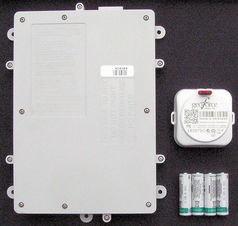
The Geoforce GT0 leverages over a decade of lessons learned. It incorporates the smallest, lowest power simplex transmitter, salvaging 33% of power required for satellite communications. It also uses the Origin Spider GPS module, which includes the latest SiRFstarIV GPS chipsets, harvesting 50% of the power for location fixes. The GT0 also incorporates the latest circular polarized antenna technology from Tallysman, with unparalleled performance compared to previously available commercial patch antennas.
The combined antenna design and power savings enable the GT0 to require only half of the batteries with an 85% reduction of device volume to achieve the same or better field service life compared with the tracker of ten years ago. The lower volume alone reduces the risk for water intrusion, but the risk is further reduced by the use of encapsulation and non-replaceable batteries. The GT0 is therefore fully sealed, disposable and encapsulated. This packaging concept makes the GT0 extremely rugged and impervious to directed water or water vapor intrusion. Thus, the GT0 is truly in a class of its own. The technology advancements and lessons learned over the past decade have enabled mechanical footprint and volumetric reduction of the global, battery-powered GPS asset tag.
The GT0 combines the smallest, lowest power satellite and GPS engines with innovative packaging to create the smallest, industrial-grade global satellite asset management tag available anywhere, setting the bar for size, value and performance.
Asset managers today need more than dots on a map. They need asset utilization metrics that provide actionable information for improving operations. Knowing where an asset is and where it is moving is sometimes enough, and for these applications GPS enabled, battery-powered tags provide supreme value.New tags provide the value of track and trace, but also can relay data from nearby sensors using short-range Bluetooth wireless interfaces.This capability will evolve the utility of yesterday’s global tag, closing the gap from location only toward satellite-based telematics, but that is a story for another day.
Gary Naden serves as Chief Technology Officer at Geoforce, manufacturer of satellite telemetry asset tags for oilfield and hazardous environment use.
Two new products have found ways to turn smartphones into personal protection devices. One of the two products includes a wearable monitor.
Photo: First Sign Technologies
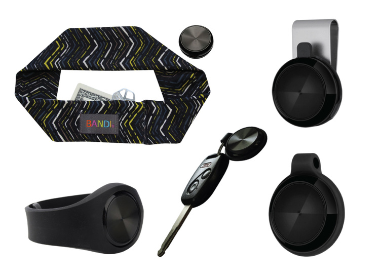
Mace Wear Pod
The Mace Wear Pod uses a wearable device in conjunction with a smartphone app. First Sign Technologies, in partnership with Mace Wear, has launched the Mace Wear Pod, which acts as a personal security system against violent crimes. At the first sign of a violent attack, an assault alarm is activated and the speaker lets the attacker know that evidence has been collected and help is on the way. The device automatically begins to collect evidence, take photos, and call for help, which will help identify, apprehend, prosecute and deter attackers, the makers say.
The Mace Wear Pod can be worn in five ways as a headband, wristband, key chain, belt clip and pendant. For those not wearing the pod, the mobile app, which can be downloaded on iPhone and Android, can also be activated in three ways, by hitting the alert button, by shaking your phone, or by setting a time to check-in — the alarm is activated if the check in doesn’t take place.
First Sign Technologies was launched in January 2014. Following a successful crowd-funding campaign, the product is now available with one year of monitoring service for $120.
“There is a demand for personal protection and with the advances in wearable technology, we want to create products that give peace of mind,” said First Sign President Rachel Emanuele. “Mace is an ideal partner to help us expand our product line and help promote safety to all who seek it.”
The products are expected to be available in more than 1,000 stores such as Dick’s Sporting Goods, Sports Authority and Sears. Demonstration videos are posted here.
Photo: STOP-ATTACK
STOP-ATTACK
Another new app launching this month, STOP-ATTACK, uses smartphone technology to send alerts in case of bullying or harassment. STOP-ATTACK, available on both Android and Apple platforms, records audio and video evidence and alerts contacts of trouble in a matter of seconds, sending GPS coordinates to a designated Panic List and first responders.
“We need to stop the senseless violence and assaults in this world,” said Anthony “Tony” Bright, the creator of STOP-ATTACK. “Our hope is that STOP-ATTACK.com will be a powerful tool in this struggle. The app has been developed with simplicity as a core feature, so that even younger children can be protected, giving parents much-needed peace of mind.” The CEO will be presenting the STOP-ATTACK app at the Pre-Grammy Awards VIP Gift Lounge and The Oscars Gift Lounge hosted by GBK productions this February.
The app can be downloaded in the Google Play or iTunes store, and is available for free now until Feb. 8, 2015.
STOP-ATTACK users will be able to customize many aspects of the app, such as creating a “Panic List” of people for the app to contact in an emergency, from friends and family to local first responders. When a user activates STOP-ATTACK, the app instantly begins recording live audio and video and uploading the stream to the cloud. Panic List contacts and designated first responders are notified immediately or after a brief, user-determined delay. The app will send the contacts a link with the GPS location and the recording of the incident.
A hot key allows for quick and discrete activation of the STOP-ATTACK app. For instance, a bully need not know they’re being recorded until presented with the evidence by a school authority. On the other hand, it’s sometimes advantageous to let everyone know that STOP-ATTACK is recording; users can choose for the app to play an alarm sound and turn on the camera light when activated, a strong deterrent to a would-be attacker.
The developers of STOP-ATTACK have created a pair of explainer videos to showcase exactly how the app works in typical usage scenarios: “Always Be Prepared,” “Bullying.”
Navman Wireless is launching an integrated vehicle tracking and camera technology product aimed at helping businesses manage risk, improve road safety, and reduce insurance costs. The product, labeled “360 Degree,” integrates telematics, vehicle tracking technology and in-cab safety camera equipment to create what Navman calls a “seamless umbrella of preventive and protective technology.”
The system is designed to help mitigate poor driving, reducing on-the-road risk. “Prevention is better than cure, and using data from telematics and vehicle tracking software to help mitigate poor driving significantly reduces on-road risk, but when you are on the road you need 360 degrees of protection,” said Hutchins.
Navman Wireless describes the in-cab safety camera equipment, supplied by Smart Witness, as a safety net. “It’s a last line of defense for drivers and fleet businesses in those unfortunate circumstances beyond their control,”said Scott Hutchins, VP sales UK and Ireland, Navman Wireless. “The introduction of in-cab camera technology not only protects the driver and business from not-at-fault claims, but also enables us to offer a complete proactive and preventative solution that has the potential to deliver measurable improvements in terms of accident and cost reduction.”
“It’s about prevention and protection. Telematics technology is integral to a successful preventive safety strategy because it can be effectively utilized to assess drivers and ensure safety and quality,” Hutchins said.
LoJack is introducing at NADA 2015 its Fleet Management Lite offering, a new version of the service designed to be an affordable, turnkey SaaS (software as a service-based) telematics solution. Fleet Management Lite will enable business owners with small- to medium-sized fleets to realize the benefits of an advanced fleet telematics system, LoJack said. The can be quickly deployed, making it a good choice for loaner vehicle fleets in many of today’s dealerships, the company said.
Another location-based program is LoJack Pre-Install, which enables automotive dealerships to pre-load vehicles in their inventory with the LoJack Stolen Vehicle Recovery System before the vehicle is sold to the customer.
“Our commitment to LoJack’s dealership network is at the center of who we are as a brand and a company,” said Randy Ortiz, president and CEO of LoJack Corporation. “Through a combination of strategic partnerships and corporate research and development, we’re fully invested in our mission to deliver sophisticated and reliable connected car and telematics solutions to the dealership community. Our goal is that each of these solutions enables dealerships across the country to increase revenue and improve operational efficiencies while effectively serving customers.”
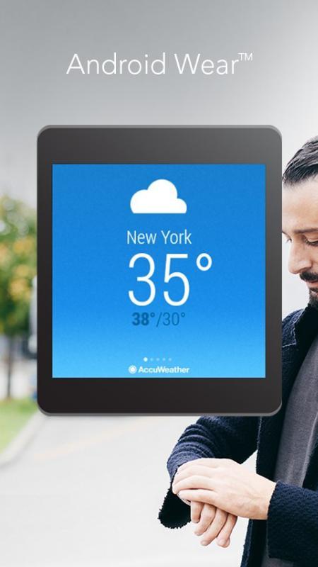
AccuWeather App for Android Wear (PRNewsFoto/AccuWeather)
The AccuWeather app for Android is now available for Android Wear, providing users with up-to-the-minute weather information wherever they go. Android Wear is the Android platform for wearables such as smartwatches. The app is available through the Google Play store.
AccuWeather’s app for Android Wear features AccuWeather MinuteCast, a global minute-by-minute precipitation forecast for a person’s exact street address or GPS location. AccuWeather MinuteCast includes precipitation type and intensity, as well as start and end times for precipitation, and gives users by-the-minute precipitation forecasts for the upcoming two hours. The GPS technology that localizes the weather to the user’s location is protected by patents in the United States and many of the major countries around the world, AccuWeather said.
In addition to AccuWeather MinuteCast, AccuWeather for Android Wear and for Android smartphones and tablets provides users with severe weather alerts, hourly forecasts, and current conditions.
“This is an exciting opportunity for AccuWeather to deliver weather information in innovative new ways to users,” said Steven Smith, chief digital officer of AccuWeather, Inc. “As the global weather leader, we provide weather forecasts wherever, whenever, and however our users most want them. Easy access, hyper localization, ease of use, and the superior accuracy that is the hallmark of our organization, help our audiences everywhere make decisions and improve their lives.”
AccuWeather MinuteCast is available for the contiguous United States, Canada, Japan, Ireland, France, Germany, Belgium, Switzerland, Netherlands, Luxembourg, the United Kingdom, and parts of the Czech Republic, with additional locations to come.
AccuWeather for Android Wear, and for Android smartphones and tablets, is available from Google Play.
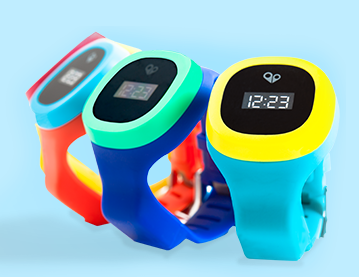
The hereO cellular GPS watch for kids will be officially unveiled at the 2015 International CES, being held in Las Vegas this week. Designed for children ages three and up, the hereO works in sync with a mobile app to provide real-time location sharing, safe-zone alerts, and group messaging, allowing parents to monitor their children’s safety and whereabouts at all times directly on their mobile phones or desktop computers.
The engineers at hereO miniaturized components to make the watch fit children’s wrists, the company said. The watch comes in a variety of bright and colorful water resistant designs to appeal to children. For parents, the hereO Family App for smartphones/tablets (iOS and Android) and desktops provides real-time location information on all family members and loved ones, plus location history, live-updates, panic alerts, safe-zone definition, and more.
“CES is a crucible of amazing minds, emerging ideas, and groundbreaking new technology; it’s the Mecca for today’s most inspired innovators,” said hereO Co-Founder and President Daniel Ivesha. “After three years of developing and perfecting our prototype, we couldn’t think of a better place to debut hereO, the world’s smallest cellular-connected GPS tracking watch for kids, which we believe is not only a game-changer in child safety technology but in the way families stay connected.”
Features include:
hereO LOCATION: Parents can locate their child anytime, anywhere. Historical locations are also available so parents can track where their child have been throughout the day.
Wi-Fi ENABLED: Wi-Fi allows indoor tracking whenever an indoor map is available. When indoor mapping is unavailable, an indoor confirmation will be sent to the parent’s smartphone.
SAFE-ZONE ALERTS: Parents can create Safe Zones for frequently visited areas (kindergarten, office, etc.) and are notified when their child arrives or departs from that location.
PANIC ALERT: In case of an emergency, children can use their hereO watch to send a panic alert that immediately notifies family members of their location.
TAMPER ALERT: Parents receive an alert when any authorized person tries to remove the watch.
EMERGENCY TRACKING: In emergency situations, parents can turn on real-time tracking to facilitate locating the child.
TIME DISPLAY: Time is displayed on a beautiful e-ink display.
USB charger: Built-in USB connector allows portable charging. Simply plug the hereO watch into any USB port to charge and to get firmware updates.
LONG BATTERY LIFE: With our standby mode, the hereO watch can last up to 60 hours.
BUILT-IN SIM: Each hereO watch is equipped with a built-in SIM card that works in over 120 countries, making it the perfect travel companion.
The hereO watch retails for $179, which includes a three-month subscription to the hereO Family App. Thereafter, a monthly fee of $4.95 applies.
At CES, the hereO watch is at booth #74545 (Tech West: Sands Expo at The Venetian).
Record-Breaking Year Ahead: Industry Revenues to Reach All-Time High of $223.2B in 2015
Revenues for the consumer electronics (CE) industry are projected to grow three percent in 2015 and to reach an all-time high of $223.2 billion, according to The U.S. Consumer Electronics Sales and Forecasts, the semi-annual industry report released today by the Consumer Electronics Association (CEA). The total revenues forecast was announced by CEA President and CEO Gary Shapiro during his opening remarks today at the 2015 International CES, running January 6-9 in Las Vegas.
CEA’s consensus forecast reflects U.S. factory sales to dealers and covers more than 100 CE products. The twice-annual report serves as a benchmark for the CE industry, charting the size and growth of underlying categories.
Emerging Technologies
The 2015 forecast projects that revenue for new, emerging product categories is expected to double, growing 108 percent year-over-year in 2015. These new technology categories include unmanned systems (unmanned aerial vehicles, unmanned vehicles and home robots); wearables such as health and fitness devices, smartwatches and smart eyewear; IP cameras; 3D printers; 4K Ultra-High Definition televisions; and connected thermostats.
While the emerging product categories represent less than five percent of the entire CE industry revenue forecast, they are expected to contribute almost $11 billion to overall CE revenue in 2015.
“Our forecast underscores that consumers’ love affair with technology shows no signs of slowing any time soon,” said Shapiro. “Consumer technology is all about continued innovation. In the blink of an eye, consumer demand has taken off for emerging categories such as wearables, unmanned aerial vehicles and 4K Ultra HD — categories that were too small to track just three years ago. Expect to see these burgeoning categories, as well as innovations across the full spectrum of consumer technology, on display this week at the 2015 International CES.”
The Wearable Revolution
The wearable device revolution is a key category to watch in the coming years, and especially in 2015. CEA projects overall wearable unit sales will reach 30.9 million units (a 61 percent increase from last year) and generate $5.1 billion in revenue in 2015 (a 133 percent increase). CEA’s wearables category encompasses fitness activity bands and other health and fitness devices, as well as smartwatches and smart eyewear.
Health and fitness devices: Led by the popularity of activity tracking devices, health and fitness devices will lead unit sales among all wearables in 2015 with a projected 20 million units. Revenue is expected to surpass $1.8 billion in 2015.
Other mobile devices:
Smartphones: As the sales leader of the industry, smartphone unit shipments are projected to reach 169.3 million this year, up six percent from 2014. Additionally, smartphone revenues are expected to generate $51.3 billion in 2015, a five percent increase from last year. Particular growth will be seen in screen sizes between 5.3 inches – 6.5 inches.
Tablets: Unit sales of tablets are projected to reach 80.7 million this year, a three percent increase from 2014. Revenues for tablets will reach $24.9 billion this year, down one percent.
“Mobile connected devices have reached an equilibrium, stabilizing the steep climb these products have experienced in recent years,” said Shawn DuBravac, Ph.D., chief economist, CEA and author of CEA’s soon-to-be released book Digital Destiny: How the New Age of Data Will Transform the Way We Work, Live, and Communicate. “Overall, improving economic conditions, consumer enthusiasm for new features and product categories, competitive manufacturer pricing and several other dynamics now at play should make 2015 an especially significant year for tech.”
Other CE categories expected to enjoy positive growth in 2015 include audio, electronic gaming and laptops. Automotive electronics will see continued growth due to new vehicle sales in 2015, reaching $14 billion in revenue, a 3.3 percent increase.
The U.S. Consumer Electronics Sales and Forecast 2010-2015 (January 2015) is published twice a year, in January and July, reporting U.S. factory sales-to-dealers. It was designed and formulated by CEA to be a comprehensive source of sales data, forecasts, consumer research and historical trends for the consumer electronics industry.
Tracking device maker Trackimo will make its official North American debut at a press conference on Jan. 7 during the 2015 Consumer Electronics Show in Las Vegas. At the press conference Trackimo will showcase its new line of tracking devices that will be introduced throughout 2015. Trackimo will also announce its partnership with Trackimo North America as an exclusive U.S. and Canadian distribution partner.
Trackimo was founded and is based in Israel. The company already has distribution deals in Latin America, Europe and Israel. The new distribution partnership in North America will offer its product to the mass market, according to Trackimo.
“We are very excited to be able to provide Trackimo’s cutting-edge technology at an entirely new price point that virtually sets a new mass market segment for tracking devices,” said Shai Bar-Lavi, CEO and Chairman of Trackimo, Inc. “We offer a whole new approach to tracking that enables consumers to use our products and services in ways that were not possible before.”
“We’re very excited to be part of the Trackimo Worldwide team and to be launching Trackimo into the North American market,” says Jim Prandine, vice president of sales, Trackimo North America. “Trackimo Universal covers dozens of applications in various channels, and our new upcoming products will broaden consumer demand even further.”
Bar Lavi added, “We are very excited about this new partnership with Trackimo North America as it opens up limitless opportunities for the Trackimo brand.”
Debuting at CES:
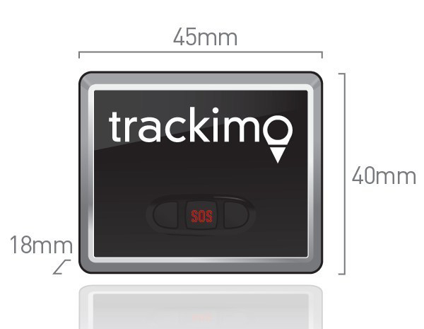
Trackimo Universal: A compact (45 x 18 x 40 millimeter), lightweight device with long-lasting battery life and worldwide service. Included accessories allow users to secure Trackimo device to different objects, including backpacks, bikes, belts and luggage. Trackimo Universal can also be hardwired in a car, eliminating the need for charging. Designed for outdoor use, the Trackimo device also includes accessories for waterproofing.
The Trackimo app offers a single-point login for both computers and mobile platforms to allow effortless management of tracking units. It offers multiple device management under a single account, as well as, a variety of remote settings options.
Highlights of Trackimo’s products include:
Dynamic Tracking Frequency: User-controlled location sampling enables optimized energy consumption.
Smart Alerts: User alerts via text, email and app notifications for location change, speed thresholds, sudden movement or impact, or SOS button press.
Dynamic History: All tracking history is stored; user can recall any time period and select from a variety of time resolutions.
GPS Tracking: Highly accurate locations when GPS reception available, but capable of accurate tracking wherever cell phone reception is available.
Virtual Fences: User-defined “geofences” give notifications when specific boundaries are crossed.
Multiple Devices: Multiple devices can be simultaneously tracked and managed on a single account.
Coming soon: Emergency Voice Channel: Voice channel can be opened automatically when SOS button is pressed, allowing remote user to hear what’s happening on site.
Wi2Wi Corporation is releasing the W2SG0021i, a miniature GNSS module based on the CSR SiRFStarV chip.
The W2SG0021i is a high-sensitivity, low-power stand-alone receiver designed for portable applications. It can concurrently track multiple satellite constellations (GPS, GLONASS, BDS, SBAS, and is Galileo-ready) and has ultra-fast time-to-first-fix, a small form factor, and high receive sensitivity for a broad spectrum of OEM products, including machine-to-machine (M2M) and consumer wearables.
The module provides precision commercial-grade GNSS location identification over -40C to +85C. Measuring 7 x 7 millimeters, the W2SG0021i addresses the need for a cost-effective and high-performance GNSS module for major markets worldwide, the company said.
M2M and wearable markets require GNSS modules with high position accuracy, low power, and very small form factor, said Wi2Wi CTO and vice president of engineering Tony Fardanesh. Wi2Wi pushes these limits in its GNSS, Wi-Fi, and Bluetooth solutions, he said.
Precision location features and the small form factor of W2SG0021i enable Wi2Wi to penetrate into the GNSS market globally. Wi2Wi continues to invest in the research and development of high-precision connectivity solutions, timing devices and frequency controllers to the global customer base, said CEO Hans Black.
The W2SG0021i samples and development kit will be available in Q1 2015.
Wi2Wi designs, manufactures and markets miniaturized embedded wireless connectivity solutions (incorporating both hardware and software), high-precision timing devices, and frequency controllers for premium industrial/medical, avionics, home automation and government markets.
Satellite TV pirates beware: Broadcom Corporation is offering a GPS-enabled satellite outdoor unit (ODU) device that gives satellite TV providers a way to track subscriber equipment, pinpoint service issues in the home, and stop piracy with a geo-lock. The solution will also enable delivery of location-based services.
The ODU solution combines Broadcom’s BCM4551 satellite TV device with its BCM4771 GPS receiver.
Broadcom’s new satellite solution resides in the low-noise block (LNB) of a subscribers’ satellite dish, enabling operators to better position dish installations and reduce metering equipment costs and truck rolls. Combining GPS-enabled ODU technology with a set-top box, operators can quickly locate and validate a subscriber’s home location, Broadcom said.
“By combining Broadcom’s field-proven satellite ODU technology with GPS functionality, we are able to provide operators with the capability to more conveniently and cost-effectively track the location of their equipment and prevent redistribution of content to nonsubscribers,” said Nicholas Dunn, Broadcom vice president of Direct Broadcast Satellite Marketing. “This integrated technology can also open the door to operator delivery of location-based social media and business applications, providing subscribers with targeted content such as information on local service providers, retail operations and restaurants, or a specific televised event.”
GPS technology within the LNB also allows operators to geo-lock content to subscribers. Content geo-locking uses a subscriber’s location to deliver video content specific to the subscriber’s service address. This ensures the delivery of personalized services and prevents costly theft of service for operators. Previously, content geo-locking was only available through a costly external device attached to subscriber’s set-top box; today’s introduction from Broadcom offers best-in-class capabilities at an incremental cost for operators.
Key Features of the BCM4551
Highly-integrated 28 nanometer (nm) process with low power consumption
Allows 24 DVB-S2 channels to be stacked on a single coaxial cable to service any STB to reduce satellite operator installation costs
8 RF inputs and 1RF output covering the 250 to 2350 MHz frequency range
24 user-band output channels
24 output channels selectable from any LNB input
Frequency shift keying (FSK) and digital satellite equipment control (DiSEqC)
Key Features of the BCM4771
Highly integrated radio frequency (RF), baseband processor and CPU with smallest complete PCB footprint
Faster signal searches, accurate real-time navigation and improved tracking sensitivity
Increased satellite availability: supports GPS, and GLONASS satellites at L1 frequency band.
Broadcom will demonstrate the new solution at the International CES show, January 6-9.
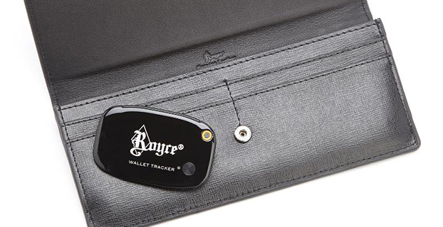
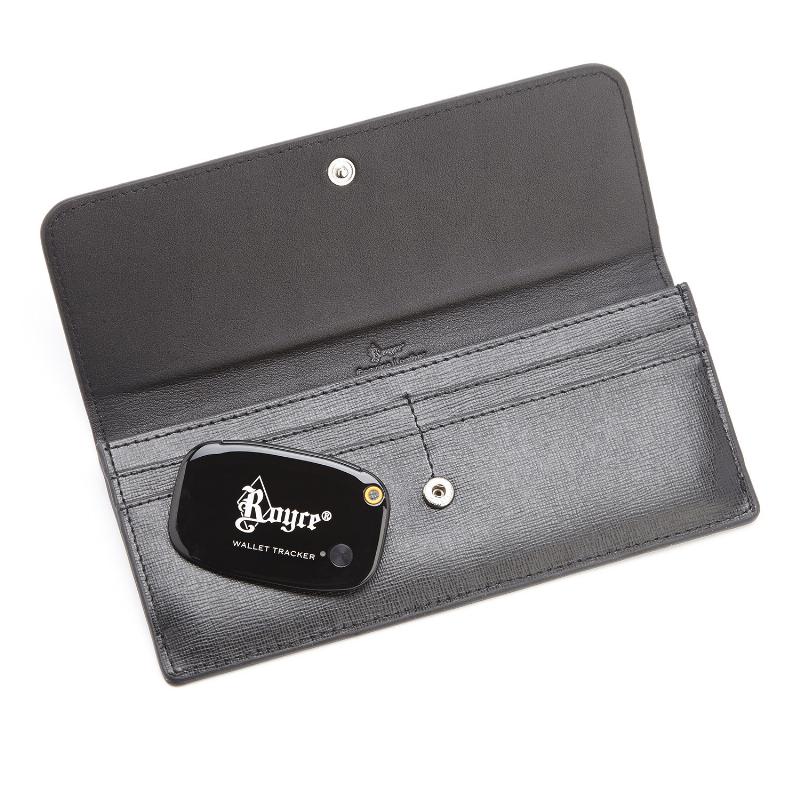
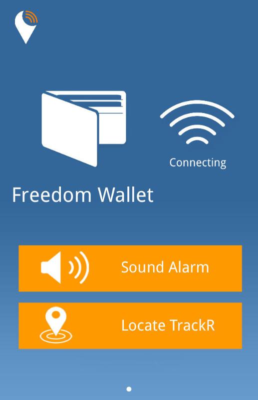
A “GPS wallet” is now being sold at Macy’s department store. Despite its name, the Royce Leather Freedom Wallet uses Bluetooth and a mobile application available on the Apple App Store and Android Market to ensure the safety of your money, according to Andrew Royce Bauer, CEO of Royce Leather.
Bauer told GPS World that the wallet “utilizes Bluetooth technology through a mobile application within a GPS range of 100 yards in addition to crowd GPS technology, in which every active user can act as a point of location reference.”
When activated, the “GPS tracker” can pinpoint the location of a lost or stolen wallet. It also has RFID blocking technology to prevent identity theft by blocking waves from scanning devices that can read and store personal information.
“With the advances in 21st century technology, I was determined to create something better,” Bauer said. “The greatest gift the Royce Leather Freedom Wallet offers is the security of not losing what you already have.”
The wallet’s mobile technology was designed in California; the leather is Italian Saffiano. According to Royce, the wallet meets the rapidly growing demand for luxury technology. “With this new design, I was determined to elevate the functionality of the traditional wallet,” Bauer said. “You should never lose it.”
Photo: Royce
The product exclusive to Macy’s is part of a larger fashion accessories collection by Royce Leather. Other styles include the use of DNA-based fingerprint technology and the RFID blocking technology.
“The Royce Leather Freedom Wallet will financially make a long-term difference in the life of my client,” Bauer said. “Most importantly, the product will reduce the time, stress, and anxiety we have worrying about where our money is. Thankfully, a problem has been solved.”
Besides the wallet, the designer collection exclusive to Macy’s features the Royce Leather Freedom Briefcase; the world’s first security bag with DNA-based fingerprint technology. The product enables a single user to access the bag, demonstrating the ultimate in personal and travel security.
The collection by Royce Leather also includes bags, wallets, and handbags for men and women with fingerprint technology, RFID blocking technology, and the Bluetooth “GPS” technology.