Mitch Narins is the principal consultant and owner of Strategic Synergies LLC, a technical and management consulting firm that he formed after retiring following over four decades of U.S. government service. He worked at the Federal Communications Commission as an acquisition engineer for the Field Operation Bureau; supported the U.S. Navy and U.S. Marine Corps as branch chief for Data Terminal Systems and Electronic Warfare Systems; and served more than 26 years at the Federal Aviation Administration as a program manager, systems engineer, and finally as the chief systems engineer for navigation.
At the FAA, he was integrated into all aspects of aviation sector position, navigation and time systems engineering, standards development, and enterprise architecture efforts in support of the National Airspace System and the Next Generation Air Transportation System (NextGen).
Narins is a recognized position, navigation, and timing (PNT) expert, who has published numerous articles and delivered many papers at conferences and seminars worldwide. He is a Certified Information Systems Security Professional (CISSP), a Fellow of the Royal Institute of Navigation, an active member of the Institute of Navigation (ION), and a member of RTCA, RTCM, and SAE Standards Committees. He is a recipient of ION’s Norman P. Hays Award and the International Loran Association’s President’s Award and Medal of Merit.
Stuart Riley
Stuart Riley is vice president of GNSS technology responsible for GNSS signal processing and products for several Trimble business areas. In this role, he is responsible for the core GNSS technology from signal reception through to the measurement engine that is used in all Trimble GNSS precision products. He oversees GNSS product development for Trimble’s GNSS Real-time Networks, Geospatial, Heavy Civil Construction and InTech OEM Divisions.
Beginning his career at Trimble in 1995, Stuart has worked on GNSS receiver development in various engineering roles, in addition to holding several management roles. He holds several patents filed and pending in the field of GNSS and is often a guest speaker at international conferences.
His research interests include improving GNSS performance in harsh environments, and taking measurements from additional sensors along with optimizing the GNSS receiver architecture, especially for the newer GNSS signals BeiDou, Galileo, IRNSS, QZSS and next-generation GPS and GLONASS signals.
Riley has an electronic engineering Ph.D. in the field of GNSS from the University of Leeds in England. After he graduated, he was a research fellow at the university on a European Space Agency-funded project to develop a prototype GNSS receiver for space applications.
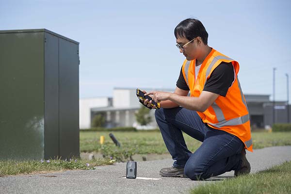
TDC’s Freeance field applications leverages Trimble GNSS for accurate, streamlined data collection
TDC Group has joined Trimble’s GIS (geographic information system) Business Partner Program. As part of the program, TDC has implemented the Trimble Precision SDK (software developer kit) to integrate high-accuracy positioning capabilities in its Freeance mobile software applications running on tablets and smartphones using Trimble GNSS receivers.
Freeance provides field crews with simple yet powerful and configurable location-based mobile apps to manage data collection and inspection activities across utility and public works organizations. By adding the Trimble R1 and R2 receivers to Freeance workflows, users are empowered with real-time access to high-quality, reliable data.
The Trimble R1 receiver will be accessible with TDC’s Freeance software. (Photo: Trimble)
“Trimble recognizes the value our GIS software partners bring to our customers by delivering targeted, industry-specific solutions,” said Stephanie Michaud, strategic marketing manager, Trimble Survey & Mapping Field Solutions. “We’re very pleased to collaborate with TDC and leverage their domain expertise, and to integrate Trimble technology into the Freeance solution for the utilities and public works markets. As a direct result of this relationship, Freeance users can now work with the confidence of knowing their field workflows are precision-enabled with Trimble GIS technology.”
“We’re excited about the integration of high-accuracy Trimble GNSS receivers with Freeance software that enables organizations to add sub-meter or better accuracy to mobile workflow activities using smartphones and tablets,” said Matthew Reddington, CEO of TDC Group. “Adding high-accuracy positioning to field workflows by means of simple mobile apps paired with Trimble GNSS increases the quality and uses of data captured during field operations.”
A roundup of recent products in the GNSS and inertial positioning industry from the June 2020 issue of GPS World magazine.
OEM
GPS Tester
Compact antenna testing for mobile deployments
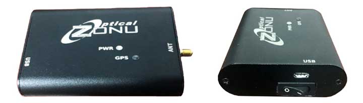
Photo: Zonu
The ZonuSkyShot is designed for quick testing during the critical installation phase of an antenna at a new site build or small-cell integration. The compact tester is designed for integrating a Zeno GPS solution, but works as a neutral testing device. SkyShot is a compact GPS receiver that detects the presence of a GPS signal, indicated on the top-panel LED. The receiver can be accessed via the USB port on the base unit, allowing the user to see the available satellites by using the app provided with the system and available at the Optical Zonu website. The receiver can simultaneously track up to 16 satellites while searching for new ones. Because of this, a problem can be found and mitigated when a GPS antenna is installed, rather than when hardware is being integrated further down the line. Close-out of projects can be indicated with screenshots of satellite visibility via the micro-USB port to a laptop.
Seamless installation on leading 2020 police sport utility vehicles
Photo: PCTEL
The Trooper TRP-20INT antenna platform supports the high-speed requirements of complex RF communication systems used for critical communications in FirstNet public safety and intelligent transportation systems. The antennas feature two 5G elements compatible with cellular routers supporting 600-MHz to 6-GHz frequencies. PCTEL’s proprietary high-rejection multi-GNSS technology is included for high-precision tracking and asset management.
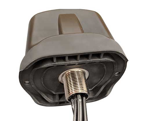
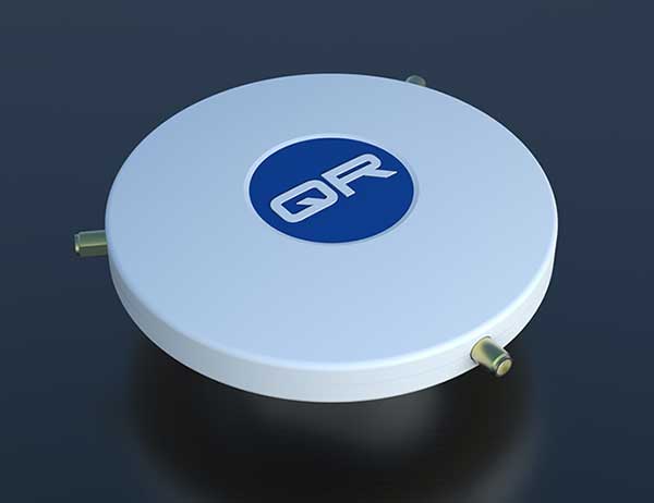
The QR-100 L1/L2 GPS anti-jamming unit mitigates RF interference or jamming signals using a spatial domain of an antenna array reception pattern. Three passive antennas of the customer’s choice can be connected to the QR-100 unit using built-in SMA connectors. The unit default configuration (no jamming signal present) has a 120-degree phase gradient between antenna elements to maximize the reception of GPS right-hand circularly polarized (RHCP) signals. This feature allows the unit to be connected to either RHCP-type antennas or linearly polarized antennas. The default configuration of the unit is designed to connect to passive GPS antennas.
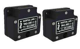
Inertial Labs’ TAG-200 two-axis and TAG-300 three-axis gyroscopes are developed for electro-optical systems, gimbals, line-of-sight, and pan-and-tilt platforms for stabilization and pointing applications. TAG-200 and TAG-300 use advanced-performance, tactical-grade MEMS sensitive elements to accomplish complex tasks requiring accurate stabilization of assorted platforms. The gyroscopes, designed for use in harsh environments, can withstand extreme shock and vibration in accordance with MIL-STD-810 ground mobile use. They are fully digitized, include built-in test functions and have no moving parts. The gyroscopes include low noise, low latency, wide bandwidth, high data rate, low bias drift, low VRE, high MTBF and are ITAR-free. They are factory calibrated over the operational temperature range and are quality assurance and quality compliance tested and supplied with individual calibration and acceptance test certificates.
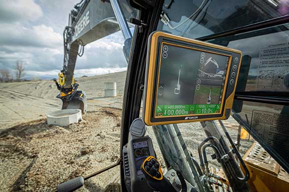
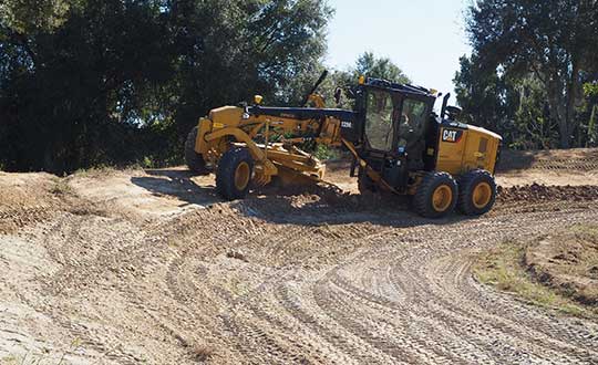
Earthworks Grade Control Platform version 2.0 features improvements to enable faster return on investment, increase productivity and decrease training time for operators. Horizontal Steering Control for dozers automatically controls the machine to follow any horizontal alignment such as a back of a curb, breakline, roadway centerline or bottom of slope, without operator assistance. Augmented reality for excavators enables users to understand 3D models, cut/fill information, slope data and other bench points and reference points on the in-cab display in context, without the need to interpret complex 2D plans or stakes. A new mastless motor grader configuration gives operators an improved range of blade motion, allowing for machine control in applications where it previously was not possible. Integrated Trimble Loadrite Payload Management displays grade control and accurate payload data on one screen, increasing mass haul productivity and efficiency by preventing underloading, and improving safety by avoiding overloading. Trimble Earthworks is also now available for compact grading attachments with dual GNSS, single GNSS and total station guidance options. The Earthworks Assistant App provides access to Earthworks learning material and documentation, allowing for a shorter learning curve and less downtime for operators.
The addition of advanced tilt and rotation functionality allows Automatic Excavator operators to easily swivel or tilt the bucket with automatic boom control for faster and more efficient excavation. If excavator operators are in situations such as at the top of the slope, grading a long incline and not totally perpendicularly lined up, the added feature makes it easier to position the cutting edge of the bucket to the surface. Operators can excavate more quickly, moving the excavator fewer times with less wear and tear on the chassis. It is also beneficial when navigating around manholes, trenches and tight spaces.
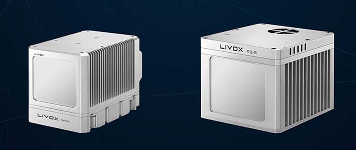
The Horizon is a high-performance lidar sensor built for Level 3 and Level 4 autonomous driving. It has a long-distance detection range of up to 260 meters, high-density point clouds, and is so small it can be embedded easily into vehicles. The Tele-15 has achieved a reliable detection range of up to 500 meters, offering improved safety for high-speed autonomous vehicles. Both the Horizon and Tele-15 high-performance lidar sensors feature a new scanning method that offers improved sensing performance at a low cost.
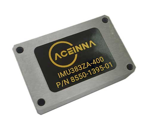
The IMU383ZA is a high-accuracy, triple-redundant inertial measurement unit (IMU) for guidance and navigation solutions in autonomous machines and vehicles. It integrates triple-redundant, 3-axis micro-electromechanical system (MEMS) accelerometer and gyroscope sensors. The IMU383ZA is pin-compatible with the IMU381ZA and offers high performance of 1.3 deg/hr, 0.08 deg/root-hr. The miniature module is factory-calibrated over the –40° C to +85° C industrial temperature range to provide consistent performance through extreme operating environments for a wide variety of applications.
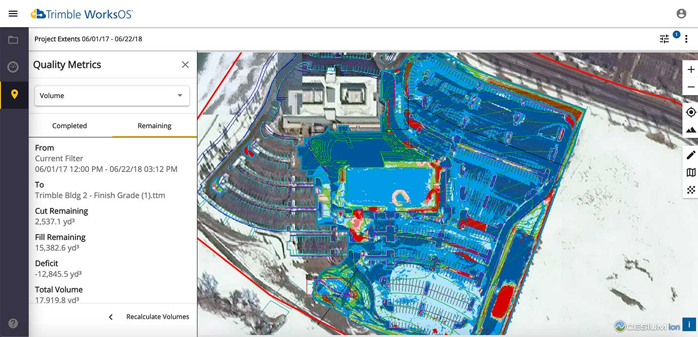
Trimble WorksOS is an upcoming civil construction software-as-a-service (SaaS) operating system. The cloud-based system will integrate data from Trimble and third-party providers across the entire civil construction project lifecycle, including estimating, scheduling, designs and the field.
Beta testing is now taking place for WorksOS, before it is released in the third quarter. Users interested in participating can go to WorksOS.trimble.com.
One-Stop Software. With WorksOS, site supervisors and project managers will be able to log into a single application to track daily production quantities, labor and equipment hours, and equipment maintenance schedules. They will be able to view real-time visibility of cut, fill, volume and compaction data to maximize jobsite productivity.
A user-friendly dashboard enables key personnel, including site supervisors, to adjust daily work targets to ensure work is progressing to plan. Site supervisors will also gain live daily volume calculations, compaction quality metrics and visibility into which machine is working, to monitor progress and determine if the project is on schedule.
Software Connections. Connecting workflows, Trimble WorksOS will integrate Trimble Business Center, Trimble WorksManager, Trimble Siteworks Positioning System, Trimble Earthworks Grade Control Platform and Trimble PULSE Fleet and Equipment Management Software.
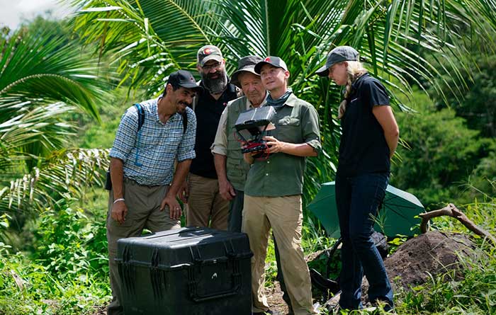
PrecisionHawk’s Jaymie Young and Matt Tompkins fly a UAV with the hosts of History Channel’s “Lost Gold of World II” in the Philippines in late 2018. (Photo: PrecisionHawk)
The collection of about 300 giant geoglyphs known as Nasca Lines were etched into the ground in the Peruvian coastal plain 2,000 years ago by the Nasca culture in South America. They depict various plants, animals, and shapes and are so large that they can only be fully appreciated when viewed from the air. Unlike the Nasca Lines, most archaeological sites are hard to see from the air, especially those deep under thick jungle vegetation, as in the lowlands of northern Guatemala. Here, lidar’s ability to penetrate foliage makes it the ideal tool for archeological exploration. At the same time, the lack of infrastructure, including airports, makes UAVs the platform of choice for many such projects.
Challenges for lidar in archaeology
Operating aerial lidar for archaeology in a jungle environment presents four challenges. The biggest one is penetrating the canopy. “Typically, the sites that they have been exploring lately have been quite overgrown, and disguising what has been there for a long time, to the extent that even someone walking on the ground has not been able to see the scope of the site,” said Paul LaRocque, senior scientist at Teledyne Optech. Penetrating multiple layers of vegetation requires a minimum of two lidar returns. For heavily vegetated environments, Matt Tompkins, director of Flight Services at PrecisionHawk, recommends a five-return system.
The second challenge is ground-truthing the data collected, explained Thomas Garrison, assistant professor in Ithaca College’s Department of Anthropology. “Even though we digitally removed the forest, it is still there, of course.” For example, it is hard to confirm long roads between sites, because they run beyond a ground observer’s field of vision.
The third challenge is acquiring a GPS signal. “In the tropical environment, a UAV needs to return to its take-off site very precisely,” Garrison explained. Finally, jungles put a twist on the familiar trade-offs between fixed-wing and rotary-wing UAVs: “A fixed-wing UAV will cover a greater area, but you may not have enough space for it to take off where you want to fly your lidar and may not be able to recover it,” Garrison said.
Making lidar an effective tool for archaeology required the development of sensors with very high pulse repetition frequencies (PRF) and with multi-look angles, which better penetrate the canopy to reach the ground and any structures, LaRocque explained.
Manned aircraft vs. UAVs
Archaeology missions need aerial lidar sensors with sufficient peak power from each pulse to reach the ground after much of it is absorbed or reflected by the canopy. In this respect, manned fixed- and rotary-wing aircraft have an advantage over UAVs because they can carry larger sensors with a higher peak power. Plus, they can cover much larger areas per flight. “This is important because archaeologists have been finding that [areas of interest] are much bigger than they ever imagined,” LaRocque said.
Finally, forests and jungles make it challenging to find open areas for launching and landing UAVs and flying them by line of sight. “Where do you stand to see the UAV above the canopy?” For these applications, LaRocque said, manned aircraft probably fly just 500 to 1,000 meters above ground level, “because they are not out for high survey efficiency but for penetration to the ground.”
Tompkins, whose company has conducted many missions in jungle environments and other remote places, takes the opposite view. Archaeology constantly presents new challenge and “takes you to some pretty crazy places,” he said and UAV lidar “allows archaeologists to access information that would otherwise be too difficult or dangerous to access.” In the projects on which PrecisionHawk has worked in heavy jungle, it has seen “excellent penetration through heavy jungle canopy, which gave us access to ground-level data,” he said.
Logistically, Tompkins pointed out, UAVs are “significantly easier and safer than manned aircraft” in remote areas with little access to airport infrastructure, air traffic control, and any sort of emergency services. A team with a UAV can mobilize and travel quickly. Where there is no electricity to recharge the UAV’s battery, the team will bring a generator.
Positional accuracy
Archaeological applications do not require survey-level positional accuracy. Archaeologists only need to be able to locate on the ground features that they identify in the 3D lidar point cloud. “We use Trimble Juno 5s, so that we can load the lidar data directly onto their screens,” Garrison said. “If we get near a structure, we only need to take a point. We don’t even need to find base stations and do corrections afterward. We can manually correct the points based on where they were on the structures.”
Ancient structures are rarely in the areas with the thickest, nastiest vegetation, which are usually low-lying areas, Garrison said. However, those areas might reveal other items of cultural interest, such as agricultural fields. “In the lidar data we have, we are seeing that ancient societies were terraforming their entire landscape, so everywhere you go there is something to check or confirm.”
Missions
In 2018, PrecisionHawk conducted an archaeological project in a remote jungle in the Philippines for a History Channel show called “Lost Gold of WWII.” Show producers were trying to find where Japanese troops might have stored gold stolen from the Philippine government.The team flew lidar on a UAV to identify roads or other manmade structures that could help them identify possible hiding spots in areas pinpointed through historical documents, Tompkins recalled.The PrecisionHawk team produced a colorized lidar data file in the jungle that the producers used on the program.
The largest lidar acquisition for archaeological investigations in the world is the Pacunam Lidar Initiative (PLI), a consortium of scholars funded by the Guatemalan foundation Pacunam (short for Fundación Patrimonio Cultural Y Natural Maya). So far, the PLI has scanned about 7,000 square kilometers in the lowlands of northern Guatemala.
Garrison is one of three principal consultants for the foundation. “Lidar has a huge impact in archaeology under tropical forests because you get more bang for the buck in terms of peeling back the forest and revealing the preserved ancient landscapes underneath,” he said. “We’ve been working on these data since we first flew in 2016 with the National Center for Airborne Laser Mapping in Houston. We published preliminary results in Science in 2018.” In the massive PLI project, “Instead of just single sites, we can see broad trends across huge areas.”
The first phase of the Pacunam lidar initiative covered 2,100 square kilometers in northern Guatemala in 10 different polygons of data acquisition. “We found that there were 60,000 more structures in these areas than we knew about before,” Garrison said. This raised the question of how so many people could feed themselves. The lidar data revealed that they had used huge swampy areas as agricultural fields. It also revealed many road systems between and within these sites and many defensive earthwork features of military engineering for warfare distributed along the valleys.
“All of that changed our view of what this ancient landscape looked like,” Garrison said. In the summer of 2019, the project flew another 5,000 square kilometers and is now analyzing the data, which shows “a complete picture of an ancient culture’s impact on the landscape,” Garrison said. “When you think of ancient Rome and everything that they had, you can’t really see everything because modern Europe is there. But here we have all this stuff preserved under the jungle in a way that is letting us see the totality of an ancient culture.”
Discoveries made with UAVs
• Using UAV lidar, the Crow Canyon Archaeology Center and the Canyons of the Ancient National Monument were able to map an 800-year-old Pueblo site at Sand Canyon, Colorado, and discover previously undocumented structures. UAV experts from Caddis Aerial and Routescene conducted the survey using a Velodyne HDL32 lidar scanner on a DJI M600 Pro UAV flying at 40-meter altitude relative to the take-off point. They then processed the point cloud, consisting of 3.2 billion points, using Routescene’s LidarViewer Pro software and created a digital terrain module at 400 points per square meter.
• A hexacopter built with DJI technology, flying 20–60 meters above the ground, enabled Isabelle Heitz of AirD’éco to map several ancient sites, including the microtopography of an ancient theater covered by woods in the center of Soissons, a town in eastern France, and a fortified town of the Gallic age, now covered by thick woods.
• Using Google Earth, satellite imagery and low-flying UAVs, archaeologists Sarah Parcak and Christopher A. Tuttle discovered a previously unknown monumental structure that had been hidden in plain sight only half a mile from the World Heritage site of Petra, Jordan.
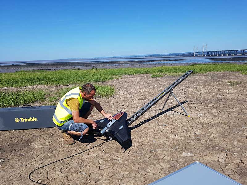
Prepping for flight: Andreas Garbe, AgSurvey, sets up the UX5 HP for a topographic survey at Severn Beach, a village in South Gloucestershire. (Photo: Trimble)
Based in Bristol, AG Surveys has been collecting topographic beach surveys around the country as part of England’s Environment Agency’s coastal monitoring campaign.
In the first integrated approach of its kind in the program, AG Surveys uses the Trimble UX5 unmanned aerial system (UAS) equipped with a Trimble/Applanix GNSS receiver along with photogrammetry software. The UAS-based system has not only confirmed its viability for coastal monitoring, it has been bringing new business opportunities ashore since 2017.
For each beach, AG Surveys must provide one baseline survey based on a 5-meter grid with a height accuracy of 3 centimeters. Also required is a series of profile line surveys. Profile surveys follow pre-defined lines set every 50 meters from the back of the beach to the low tide line, with GNSS measurements taken within 10 centimeters of each side of the line.
Crews typically cover 3 square kilometers a day, flying four to five Delair drone flights at an altitude between 100–120 meters, at speeds of 80 kph and a lateral overlap of 80%. To ensure the reliability and accuracy of the UAS data, they use a minimum of 10 ground control points (GCPs) for each flight block and measure each target’s position with a GNSS receiver.
Once flights are complete, the team imports into Trimble Business Center (TBC) the flight and GNSS data and the base station survey data. Using both on-board GNSS positioning data and the ground control data, they process precise, short baselines between the base station and each photo point. All images are then integrated into Trimble’s Inpho UASMaster software to create a dense point cloud and a seamless orthophoto of the entire area of interest. (UASMaster is now integrated into the TBC Aerial Photogrammetry Module). If needed, they can also use UASMaster to produce a seamless, georeferenced orthophoto directly from the point cloud.
When Trimble sold its Gatewing fixed-wing drone business to Delair in October 2016, its decision was based on several drivers. Trimble had worked with Delair since 2008 and knew their capabilities; the company decided that a dedicated drone company should be better placed than a GNSS manufacturer to find and develop leading-edge drone business. Also, the sale enabled Trimble to better focus on integrated UAS software technology for positioning, remote sensing and photogrammetry. Delair joined up with Microdrones, a supplier of multi-rotor UAVs, to round out the team’s offerings. Both companies are skilled in the application of Trimble UAV software.
Typical Delair drone applications include rapid data gathering using the UX11 fixed-wing drone, followed by data analysis leading to highly accurate survey-grade results.
For the Johnson Poole and Bloomer (JPB) mine sites, personnel safety was an important driver in moving away from having people on the ground collect data, sometimes in dangerous situations. Time and cost savings have now become the norm for JPB survey operations, particularly for stockpile volume calculations.
With the UX11 flying at 400 feet for 40–45 minutes, up to five times each day, it is possible to collect thousands of photos of many acres — ending with an accuracy of around 1.7 centimeters.
The UX11 drone is equipped with a high-precision Septentrio AsteRx-m2, providing post-processed kinematic (PPK) multi-frequency, four-constellation signal reception. The AsteRx-m2 is also low power and low weight.
Another mining operation using Delair drone survey and analysis tools is Luck Stone in Virginia. With numerous quarries in Maryland and Virginia, Luck Stone produces aggregates and more than 75 crushed stone, sand and gravel products for civil engineering, private construction and environmental projects. Luck Stone also finds that inspection staff safety is significantly improved, as is the time for such inspections, and asset inventories are not only accurate but also can be undertaken quickly and much more often.
Delair has just released a new agriculture system with the fixed-wing Delair UX11 Ag, along with the Delair Aerial Intelligence (delair.ai) processing system. An integrated and easy-to-use workflow has been developed to collect, manage, analyze and share agriculture data for crop health monitoring, field experimentation analysis, automatic machine guidance, precision ag practices and better crop traceability.
The new system makes use of PPK for precise auto-geolocation. The UX11 Ag drone carries a fully integrated high-grade multispectral camera for the data collection and monitoring of plant health.
Delair.ai supports tools that provide visual field maps, identifying plant health by chlorophyll content, green biomass, stoutness/visual health and other plant indicators. The drone enables spray prescription preparation to counter weeds, disease and pest infiltration. UAVs also make it possible to determine the effectiveness of treatment regimes.
In addition, Delair has developed the DT26 fixed-wing series of longer range drones for two-hour lidar survey flights and for surveillance; it can be adapted to carry other customer payloads. The DT26 uses an Applanix/Trimble GNSS receiver.
Delair customers also use their drones for power-line inspections and in the oil and gas industry for site preparation surveys and pipeline inspections. The UX11 was the first drone from a Trimble partner to provide a JXL file for processing UX11 data in the Trimble Business Center.
Dynapac and Trimble are partnering to develop commercial-ready autonomy functionality for Dynapac soil rollers.
The companies first demonstrated automation of the soil compaction process at this week’s ConExpo 2020 in Las Vegas, and plans another demonstration during the Trimble Dimensions User Conference Nov. 2-4 in Nashville, Tennessee.
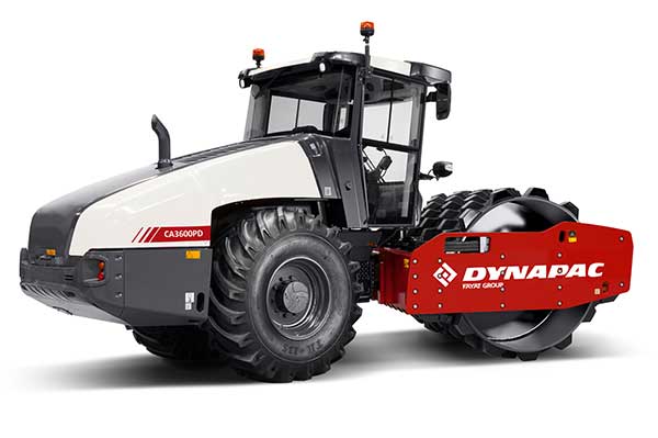
The Dynapac CA3600PD single-drum vibratory roller. (Photo: Dynapac)
Dynapac’s “Road to Autonomy” was launched with the introduction of Seismic Soil Rollers in 2019. The Dynapac-exclusive Seismic technology takes the guesswork out of the equation for operators, regarding soil type or frequency settings, the company said.
Dynapac Seismic monitors the soil properties and automatically adjusts the frequency of vibration for optimal compaction and energy efficiency. The Active Bouncing Control System automatically cuts off the vibration of the drum when the material reaches maximum compaction characteristics.
The next step on the “Road to Autonomy” is automatic steering and speed functions on the roller. The operator/site manager can use the machine to map the boundaries of the area to be compacted.
Once the machine is placed in autonomy mode, the system will take over the controls for steering and speed. This functionality will be shown at the Dynapac and Trimble booths during ConExpo 2020.
By automating these functions, operator skill gaps can be bridged, while consistent speed and steering improve compaction quality results.
The autonomous solution is built on Trimble’s control platform and utilizes Trimble’s field-proven positioning technology. Compaction documentation systems, such as Dyn@lyzer or Trimble CCS900 Compaction Control System, work together with automatic speed and automatic steering to provide documentation of the improved quality.
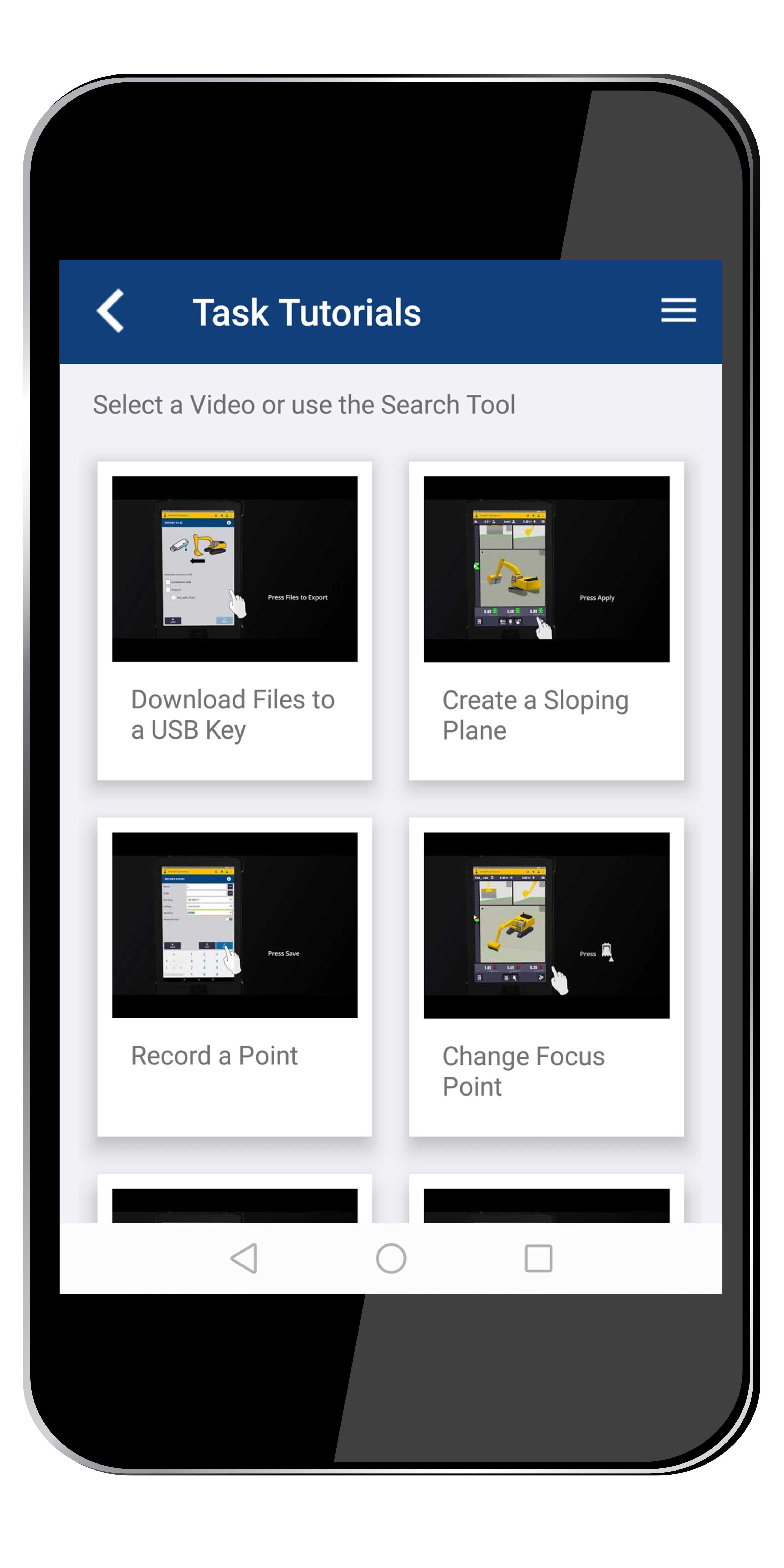
Trimble’s Earthworks Grade Control Platform version 2.0, unveiled at ConExpo-Con/Agg 2020, includes new features for all machine types.
Trimble also released the Trimble Earthworks Assistant App for in-cab learning material.
ConExpo-Con/Agg 2020 is North America’s largest trade show for construction machinery, building material machines, mining machines, construction vehicles and construction equipment. The Trimble booth is located in the Las Vegas Convention Center North Hall #N-1140.
New Features
The improvements are designed to enable faster return on investment, increase productivity and decrease training time for operators.
Horizontal Steering Control for dozers automatically controls the machine to follow any horizontal alignment such as a back of a curb, breakline, roadway centerline or bottom of slope, without operator assistance.
Augmented Reality for excavators enables users to easily understand 3D models, cut/fill information, slope data and other bench points and reference points on the in-cab display in context, without the need to interpret complex 2D plans or stakes.
A new mastless motor grader configuration gives operators an improved range of blade motion, allowing for machine control in applications where it was previously not possible.
Integrated Trimble Loadrite Payload Management displays grade control and accurate payload data on one screen, increasing mass haul productivity and efficiency by preventing underloading, and improving safety by avoiding overloading. Contractors can maximize their investment in Trimble Earthworks by leveraging the versatility of these added options.
Trimble Earthworks is also now available for compact grading attachments with dual GNSS, single GNSS and total station guidance options.
Horizontal Steering Control for Dozers
Horizontal Steering Control allows the operator to focus on the grade and machine productivity rather than worrying about steering, reducing operator fatigue and errors. It enables the machine to follow the horizontal guidance from the 3D model, providing operators increased awareness of their surroundings, better accuracy and improved productivity with decreased overlap and fewer passes.
“Trimble is on the forefront of innovation and cutting-edge technology along the path to automation,” said Scott Crozier, vice president, Trimble’s Civil Engineering and Construction. “Using proven steering technology from Trimble Agriculture, we are continuing to advance construction machine control yet again.”
Mastless motor grader
A new mastless motor grader configuration gives operators an improved range of blade motion. (Photo: Trimble)
Trimble Earthworks for motor graders mastless configuration mounts one GNSS receiver on the cab and one on the gooseneck of the machine to eliminate masts and cables traditionally located on the blade. Mastless GNSS receivers are ideal for the blade’s maximum range of motion, which is needed for steep slope work and complex designs with tight tolerances. The new configuration enables contractors to decrease risk of damage to the machine, keep valuable receivers safer as well as reduce the time needed to remove and reinstall them each day.
Augmented reality for excavators
Augmented Reality was first released in the Trimble SiteVision™ system and is now available on excavators with Trimble Earthworks. Using a camera mounted on the outside of the machine, operators can view 3D models in a real-world environment at a true-life scale, in the context of existing surroundings. On the Trimble Earthworks display, the model is overlaid onto the existing ground giving the operator a better understanding of the work that needs to be done. Visibility of the bucket gives operators better situational awareness to be able to keep surrounding people and objects safe.
“With the intersection of physical and digital worlds, Trimble is empowering contractors to accelerate their business,” said Cameron Clark, business area manager, Trimble’s Civil Engineering and Construction. “Augmented Reality simplifies complex concepts by allowing users to see a blend of digital content and real-world environments.”
Earthworks Assistant App
Trimble now has an easier way to access critical Earthworks learning material and documentation, allowing for a shorter learning curve and less downtime for operators. This stand-alone app consolidates and simplifies access to training guides and videos inside and outside of the cab. The Earthworks Assistant App makes it easy to learn and troubleshoot using an Android cell phone, even from remote sites.
Engineers are monitoring in real time the effects on Casablanca’s aging buildings during tunnel construction using a Spectra Precision GNSS receiver.
Vibrations during the construction of a new 1,890-meter tunnel adjacent to Casablanca’s Old Medina, the 250-year-old section of the famed Moroccan city, challenged the stability of its historically important buildings.
To monitor in real time the effects on the Medina’s aging buildings and to confirm that the construction work meets all engineering standards and guidelines, ETAFAT, a geospatial information acquisition and processing company, used the Nikon XF Total Station to perform more than 100 daily inspections. The ETAFAT team relied on optical targets placed on building facades whose coordinates were determined by forced centering to complete the inspections.
The new Les Almohades tunnel, beneath the Boulevard des Almohades, runs parallel and adjacent to the old Medina. Together with its 380 meters of access roads, the twin-tube tunnel, which carries traffic in two unidirectional lanes in each tube, was constructed to reduce traffic congestion.
According to ETAFAT engineers, the Nikon XF 1” with its fast autofocus function, saved considerable field time. The Nikon XF enabled fast collection of highly accurate observations throughout the monitoring and control of the planimetric and altimetric locations of the structure. The monitoring of the buildings during the various phases of the tunnel’s construction generated a large amount of data essential for understanding the consequences of the work and defining any necessary corrective measures.
The Nikon FX 1,” with its advanced options and Survey Pro software, enabled survey teams to quickly yet accurately perform a variety of other essential field tasks.
These tasks include digital terrain modeling (DTM), cubature calculations, coordinate geometry (COGO) topometric calculations and layout control with customized report generation. The use of Survey Pro software enabled ETAFAT engineers to fully integrate their total station work with their fleet of Spectra Geospatial SP60 GNSS receivers.
The Nikon XF 1” is a mechanical total station that stands up to tough worksite conditions. It is designed to quickly capture accurate measurements, and it offers crisp, clear optics for sighting in both bright and low-light conditions.
Its dual-color touchscreen displays run Survey Pro, Survey Basic and Layout Pro.
It is also equipped to take advantage of the optional Trimble Protected L2P device for asset security to locate lost, stolen or missing equipment. Its hot-swappable batteries reduce downtime and a PIN enhances security in the field.
GPS World spoke with Guillermo Perez-Iturbe, Trimble’s marketing director – agriculture, about the challenges for farms in adopting precision agriculture, including time, cost and connectivity issues in rural areas.
What technical challenges are faced in applying GNSS?
GNSS technology is at the center of precision agriculture and is one of the key enablers for the farm of the future. GNSS helps boost productivity, environmental sustainability and economic competitiveness.
Trimble’s GNSS agriculture solutions provide reliable, accurate positioning that can be tailored to meet specific needs, including different crops (broadacre vs. row crops) and activities (such as tilling, planting or fertilization). Trimble’s portfolio connects farming operations and includes guidance and steering; grade control, leveling and drainage; flow and application control; irrigation; harvest solutions; desktop and cloud-based data management; and correction services.
However, one of the challenges to fully realize the benefits of the future farm is connectivity. Typically, ag customers are in rural areas, where the available communications infrastructure to support Wi-Fi or cellular data communications varies widely. This can impact the ability to share information between field and office as well as between machines in the field.
But connectivity challenges have a lower impact on GNSS positioning. For example, farmers can leverage satellite-delivered corrections provided by Trimble RTX correction services using a compatible GNSS receiver and subscription service. This plays an important role in areas such as rural North America, Latin America and Australia. In many areas in Europe, farms can utilize a virtual reference station (VRS) for precise GNSS. There are also farms globally that operate their own GNSS reference networks or base stations to support accurate, high-precision, real-time positioning.
What are the remaining obstacles to adoption?
There is little resistance to the technology per se. The performance and value of precision farming are well known. Adoption rates can range from 80% to less than 40%, depending on geographic location, farm size (small family or large corporate farm), types of machines or crops, and etc.
Obstacles can come from multiple forms. For example, in some parts of the world farm staff may lack the skills or qualifications needed to operate the systems efficiently. To lower the barrier to entry, Trimble has designed intuitive user interfaces and displays based on an Android operating system. In some regions, taxation and import restrictions hinder attempts to implement GNSS into precise farming. There are also business-related issues. For example, a smaller farm must prioritize its investments, and improving or repairing a planting machine might be more important than installing GNSS technologies.
What does VerticalPoint RTK offer?
Trimble developed VerticalPoint RTK Grade Control to help farmers mitigate issues in water management and land forming. It provides centimeter accuracy in the vertical component. This accuracy level enables the precise grading needed to provide shallow flow and slow water movement.
When using VerticalPoint RTK, the GNSS rover receives and combines data from multiple reference stations to develop precise vertical measurements. It provides high confidence and can be used for grading, levees and berms, tile applications, and ditches. For larger-scale land forming based on precise terrain mapping, machines using VerticalPoint RTK can reduce the number of passes needed to bring the land to the designed grade and shape.
Do you have any other RTK services for precision ag?
The RTK technology used in Trimble agriculture solutions is consistent with RTK across other segments (construction, surveying, mapping and more). The differences are in the application and location, where we provide a variety of receivers, user displays, machine interfaces and software to produce accurate, reliable performance. The activities can range from tillage and grading to planting, adding inputs such as fertilizer or weed control — all the way through harvest. It is just a matter of talking with the farmers to understand their operations; we can then select and integrate components to optimize the solution.
As part of this, farms using Trimble RTX correction services can choose different levels of service based on their needs. This approach enables farmers to achieve (and pay for) only the accuracy they need. For example, some basic tillage operations can use RangePoint RTX with good results. Other applications, such as fertilizing row crops, may require the 2.5-centimeter accuracy provided by Trimble CenterPoint RTX corrections service.
The automatics on Trimble’s Earthworks Grade Control Platform enabled construction of a tricky retaining wall. (Photo: Trimble)
Based in Vandalia, Ohio, R.B. Jergens has long been an early adopter of technology. The company purchased its first GPS-based surveying equipment, a Trimble base station and rover, in 1999 and has never looked back.
The company has relied heavily on the Trimble GCS900 Grade Control System with automatic blade control for years, and recently put the new Trimble Earthworks Grade Control Platform to the test on several of its excavators.
“While the user interface is completely different, moving from a soft key control box to a touchscreen control box, the transition from the GCS9000 has not been difficult,” said David Reynolds, surveying manager with R.B. Jergens.
The new Earthworks platform includes intuitive, easy-to-learn software, is extremely customizable, and allows each operator to personalize the interface to maximize productivity, regardless of his or her experience or skill level. When the excavator is placed in “autos” or automatics mode, the operator controls the stick, and Trimble Earthworks controls the boom and attachment to stay on grade for a more consistent grade and higher accuracy in less time.
One of the first jobs that the R.B. Jergens team used the Earthworks Grade Control Platform on was to construct a 1,000-foot-long ditch with a very flat profile of about 0.2%.
A transmission tower complicates construction. (Photo: Trimble)
“For this type of task, the automatics functionality is invaluable, because an operator would have a very difficult time maintaining fall,” said Reynolds. “It averages out to less than 3 inches over 100 feet, which is almost impossible to eyeball.”
Traditionally, on a job with that flat of a profile, the surveyor would have had to set frequent grade stakes.
“We used the automatics feature to construct the ditch and ensure that it held a consistent profile per the design specifications, even though the profile is extremely flat,” Reynolds said.
A particularly challenging automatics-enabled project was the excavation near a transmission tower for construction of a soil nail retaining wall. Crews needed to excavate around the tower without undermining the integrity of its foundation.
The soil nail retaining wall is 25 feet tall and about 150 feet long. To complete the job, the R.B. Jergens crew would excavate and expose up to five vertical feet of the bank face. Then the retaining wall contractor would drill holes in the soil, install and grout the steel rod, attach plates, and cover the face with a cementitious shotcrete. “We used the autos on the excavator to perform all of the excavations,” Reynolds said. “Without machine-controlled guidance and the automatics capability to pull those slopes in so tightly, I’m not sure how we’d have done this job.”
Reynolds estimates that the surveyor and field crews saved three days of time each on the job — at least 40 hours total — with the use of automatics.
“We’ve been able to reallocate resources more effectively and increase our productivity anywhere from 50 to 100%, so we’re leaner and more profitable.”