Tag: Trimble

  • Launchpad: UAV that follows, tracker with hotspot, tilting GNSS antenna

    A roundup of recent products in the GNSS and inertial positioning industry from the December 2018 issue of GPS World magazine.

    OEM

    Combination antenna

    Long-range connectivity

    Photo: Molex
    Photo: Molex

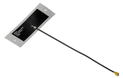
    The Molex highly compact 2.4/5-GHz combination GPS/Wi-Fi ceramic antenna is designed to be a cost-competitive solution covering the full GNSS band, 1.561 to 5.85 GHz. The triple-band ceramic antenna has Wi-Fi HaLow compatibility and is interference-resistant, supporting larger but lower (900-MHz) frequency ranges than 2.4/5-GHz connections. It also operates with lower power over longer ranges than 2.4/5-GHz Wi-Fi. Advanced Wi-Fi applications the internet of things, connected cars, smart homes and smart cities.

    Molex, www.molex.com

    GNSS module

    Built-in flash memory

    Photo: Fujitsu
    Photo: Fujitsu

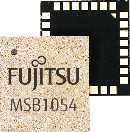
    The MSB1054 multi-receiver module requires no external components, meeting needs of smartwatches, fitness trackers, logistics and navigation. Its Flash memory saves navigation data to optimize performance and provide a hot start. The ability to receive signals from several satellite systems significantly reduces the time to first fix. The module provides a built-in RF-front end (SAW filter, low-noise amplifier) as well as a temperature-compensated crystal oscillator (TCXO), so no external component is required other than an antenna. It measures 5.8 × 6.2 × 1 millimeters and uses 3.4 mA current in low-power mode, such as for tracking.

    Fujitsu Electronics Europe, www.fujitsu.com/uk/

    GNSS IoT module

    Aimed at European market

    The GE310-GNSS module. (Image: Telit)
    The GE310-GNSS module. (Image: Telit)

    The GE310-GNSS is an internet of things (IoT) module with GSM/GPRS, multi-constellation satellite positioning and Bluetooth functionality in a 270-millimeter-squared form factor. It meets European demand for GSM/GPRS compact form factors and is part of Telit’s migration-support program that helps customers leverage 2G’s low cost and broad coverage while preparing for 4G and 5G. The GE310 enables OEMs and system integrators in asset management, utilities and telematics to meet the strong demand for low-cost, highly compact devices without tradeoffs in performance, reliability and functionality, particularly in regional markets such as Europe, where 2G is forecast to remain in strong growth in number of IoT connections for many years.

    Telit, www.telit.com

    GNSS/INS board

    With multi-sensor fusion positioning and orientation

    Photo: Unicore
    Photo: Unicore

    The CLAP-B multi-GNSS/MEMS integrated inertial navigation board features a miniaturized high-performance inertial measurement unit (IMU) on a compact high-performance GNSS board. The high-accuracy GNSS positioning coupled with a high-precision gyro and accelerometer provides stable, continuous 3D position, velocity and attitude, as well as original acceleration and angular velocity measurements, even in GNSS-denied environments. CLAP (Concurrent Localization & Attitude Pilot) technology is a high-precision multi-sensor fusion positioning and orientation technology developed by Unicore. The board is compact, light weight and has low power consumption. It is designed for ease of integration and mass production, and is suitable for autonomous driving, smart surveying and UAVs.

    Unicore Communications, www.unicorecomm.com
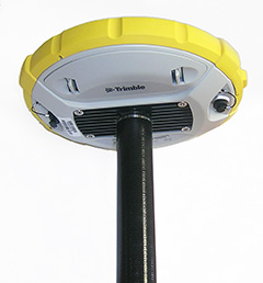
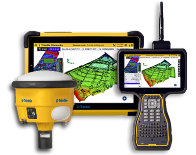
    GNSS receiver

    Can serve as base station or rover

    Photo: Marxact
    Photo: Marxact

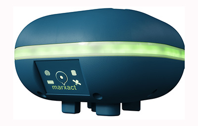
    The UNI-GR1 RTK GNSS receiver offers highly accurate heading and positioning output. It can be connected to any device through Wi-Fi, mobile data, radio, USB or serial cable. It simultaneously tracks GPS L1/L2/L5, GLONASS L1/L2, Galileo E1/E5a/E5b and Beidou B1/B2/B3 on 432 channels. The receiver has a built-in level, a LED ring driven by a nine-degrees-of-freedom inertial measurement unit. Users can configure numerous settings such as real-time kinematic, or begin surveying immediately with a smartphone or laptop.

    Marxact, www.marxact.com
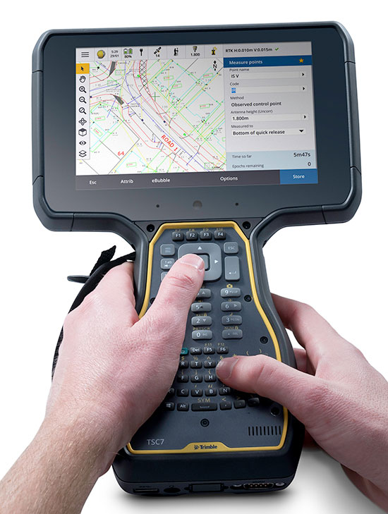

    SURVEY & MAPPING

    Smart antenna tilt

    Designed for rugged jobsites

    Photo: Trimble
    Photo: Trimble

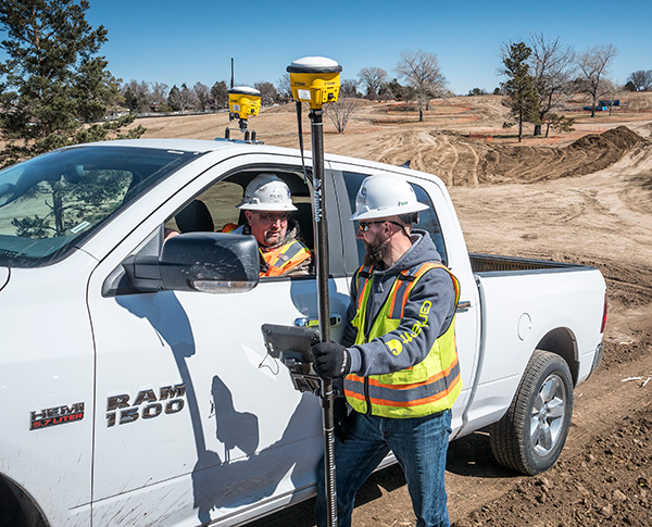
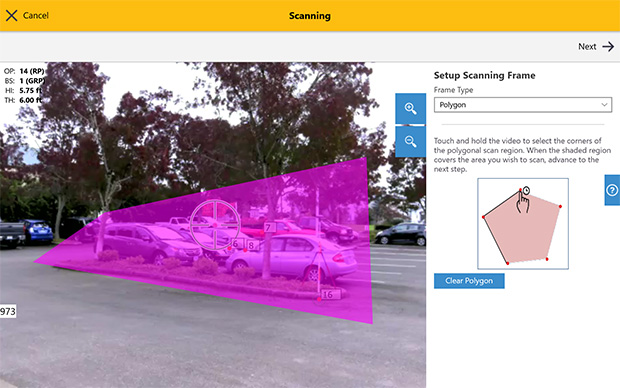
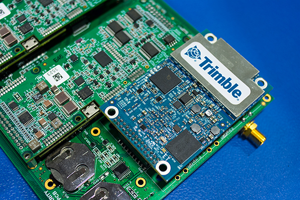
    Dynamic tilt functionality has been added to the Trimble SPS986 GNSS smart antenna. The dynamic tilt upgrade allows for faster data collection to enable construction surveyors to create larger digital terrain models faster and with improved accuracy. It can capture higher accuracy measurements on steeper slopes from a moving vehicle and more accurate volume measurements to save time and money on material planning. The dynamic tilt measurement mode also auto-measures antenna height. From inside the vehicle, contractors can set the height of the antenna and quickly interrogate surface models using the real-time 3D surface display in Trimble Siteworks field software.

    Trimble, www.trimble.com

    On-site data processing

    With Kespry and DJI drones

    Edge1 base station. (Photo: Skycatch)
    Edge1 base station. (Photo: Skycatch)

    The Skycatch Edge1 is an on-premise data processing and GNSS base station optimized for the Skycatch Explore1 and DJI Phantom 4 RTK drones. Field teams can fly a drone, process the data and receive centimeter-level data output in 30 minutes or less, directly to a tablet, without the need for internet or cellular connectivity. 2D maps and 3D point clouds can be shared from the tablet. The Edge1 includes built-in WiFi, LTE and reliable sub-5-centimeter accuracy, and delivers high-quality data output. It is also capable of running deep learning algorithms to extract more insights from collected data in near real time.

    Skycatch, www.skycatch.com; DJI, dji.com

    Drone software

    To derive topographic information from drone data

    Screenshot: Virtual Surveyor
    Screenshot: Virtual Surveyor

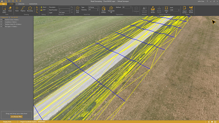
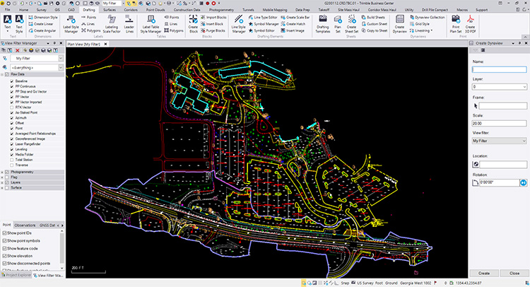
    Drone surveying software Virtual Surveyor now eliminates the need for clients to use third-party applications to prepare data for processing. Version 6.1 handles on-the-fly projections that previously required a separate software package to set the data in the proper coordinate system. It bridges the gap between UAV photogrammetric processing applications and engineering computer-aided design (CAD) packages. The software generates an interactive onscreen environment with UAV orthophotos and digital surface models where the surveyor selects survey points and breaklines to define the topography, creating highly accurate topographic products for CAD input up to five times faster than otherwise possible. Surveyors can drag and drop all kinds of files into Virtual Surveyor: points, raster, vectors and point clouds. The point clouds are converted to a DSM for manipulation and processing, dramatically accelerating the time required to generate the CAD model.

    Virtual Surveyor, www.virtual-surveyor.com

    Redistricting software

    Includes Efficiency Gap Measure to explore redistricting problems

    Screenshot: Mapitude
    Screenshot: Mapitude

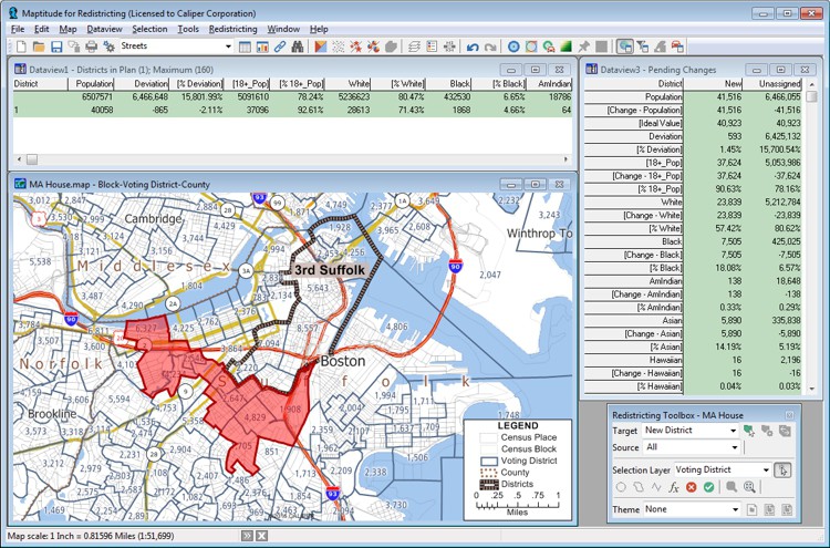
    Maptitude for Redistricting is a professional tool for political redistricting. Maptitude provides measures and reports that support the creation of fair and balanced districts, and regularly enhances the software. Maptitude was used to democratize redistricting in California and is used by redistricters from independent commissions, non-profits, and civil rights groups, to the courts and political parties.

    Mapitude, www.caliper.com

    Mining solution

    Stockpile measurements are up to 80% more accurate

    Photo: DJI
    Photo: DJI

    The DJI Mavic 2 Pro drone is now part of the Kespry stockpile measurement solution for mining and aggregates companies. Kespry’s stockpile measurement solution produces data up to 80% more accurate than manual measurement. All of the survey data is stored in a central cloud application, accessible for analysis by the entire team. Large aggregates and mining companies can standardize and capture stockpile data across all their sites in the Kespry platform, while using Kespry 2s or DJI Mavic 2 Pro drones.

    Kespry, www.kespry.com; DJI, dji.com


    TRANSPORTATION

    C-V2X Module

    Designed for next-generation automotive applications

    Image: Quectel
    Image: Quectel

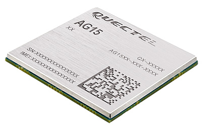
    The automotive-grade C-V2X module AG15 features the Qualcomm 9150 C-V2X chipset paired with Quectel LTE module AG35. It is designed to meet the telematics and vehicle-to-everything (V2X) connectivity requirements of autonomous driving and road safety. It features a built-in multi-constellation high-precision GNSS (GPS/GLONASS/BeiDou/Galileo/QZSS) receiver with additional support from satellite-based augmentation systems (SBAS) and Qualcomm 3D dead-reckoning technology, which improves positioning accuracy and speed while simplifying customer designs. It is designed to allow low-latency, highly reliable and highly dense data exchange between vehicles and their surroundings, enabling effective information sharing among road users to avoid collisions, thus improving automotive safety, automated driving and traffic efficiency.

    Quectel Wireless Solutions, www.quectel.com

    Automotive microcontroller

    Enables remote updates, in-vehicle networking

    Image: STMicroelectronics
    Image: STMicroelectronics

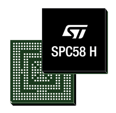
    The SPC58 Chorus H microcontroller (MCU) line can run multiple applications concurrently to allow more flexible and cost-effective vehicle electronics architectures. The line is designed for high-end body, networking and security applications such as gateways, body-control modules, battery management and ADAS safety systems. The line has three high-performance processor cores, more than 1.2-MB RAM and powerful on-chip peripherals. The MCU securely delivers updates over the air for vehicle powertrain, body, chassis and infotainment features. With high security and large on-chip code storage, ST’s Chorus automotive microcontroller is a gateway/domain-controller chip capable of handling major OTA updates securely. Two independent Ethernet ports provide high-speed connectivity between multiple Chorus chips throughout the vehicle and enable responsive in-vehicle diagnostics.

    STMicroelectronics,www.st.com

    Testing system

    For advanced driver-assistance systems (ADAS)

    Photo:
    Photo:

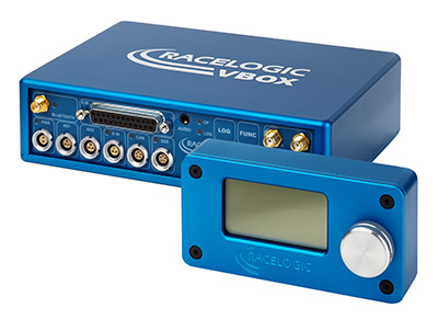
    The VBOX 3i RTK is a real-time-kinematic-enabled version of the VBOX 3i dual antenna that can be used in conjunction with an RTK differential base station to obtain ±2-centimeter positional accuracy in real time at 100 Hz. The data logger combines the advantages of a twin antenna GPS setup with GLONASS satellite tracking. It can be used in vehicle tests where positional accuracy and repeatability are of key importance, such as lane departure testing, distance to a fixed object or precise mapping. The VBOX 3i RTK comes with the VBOX manager, a display enabling users to change dynamic modes and filter settings, set up slip angle data and define antenna locations.

    Racelogic, www.racelogic.co.uk

    Tracker

    Provides built-in Wi‑Fi hotspot

    Photo: ERM Telematics
    Photo: ERM Telematics

    The StarLink TrackerWi‑Fi advanced vehicle-tracking device combines u-blox GNSS, 4G and Wi-Fi technology, eliminating the need to equip vehicles with a separate mobile Wi‑Fi hotspot. StartLink is suitable for applications for connected cars, telematics, vehicle diagnostics, fleet management, vehicle security, usage-based insurance, and rental and leasing service companies. With the Wi‑Fi hotspot, users can tap into cellular 4G to transfer telematics data to the fleet manager and send real-time data to the driver’s smart device or infotainment system.

    u-blox, www.u-blox.com; ERM Advanced Telematics, ermtelematics.com


    UAV

    Underwater drone

    Enables stable imaging

    The Notilo Plus team with the iBubble. (Photo: Notilo Plus)
    The Notilo Plus team with the iBubble. (Photo: Notilo Plus)

    Notilo Plus has launched iBubble, a fully wireless, autonomous and intelligent underwater drone that can be used for search-and-rescue operations, naval or underwater infrastructure maintenance, and subsea patroling. iBubble can accompany divers for up to an hour and down to 197 feet depth, enabling superior underwater imaging. The remotely operated vehicle (ROV) was designed using a patented underwater localization technology, which is mainly based on acoustic signal transmission and image recognition (video tracking). By combining these technologies, iBubble is able to locate precisely its target underwater and shoot stable footage. The iBubble is equipped with an obstacle avoidance system, real-time image recognition, a stabilization system and direct surface control.

    Notilo Plus, www.notiloplus.com

    Compact drone

    Captures images of inaccessible areas

    Photo: Parrot
    Photo: Parrot

    Anafi Work is an ultra compact tool for professionals, helping them make informed decisions using the drone’s aerial insights. Anafi Work includes the advanced Anafi drone equipped with an innovative imaging system, a 4K/21MP camera with a 180° vertical orientation, allowing users to capture images of inaccessible areas.The drone operates for 1 hour and 40 minutes with its 4 USB-C smart batteries. It can be transported anywhere in a compact shoulder bag. Professionals can create 3D models of buildings, quickly and easily, using a one-year subscription to Pix4Dmodel.

    Parrot, www.parrot.com

    Airborne sensors

    Laser scanners for large UAVs

    Photo: Riegl
    Photo: Riegl

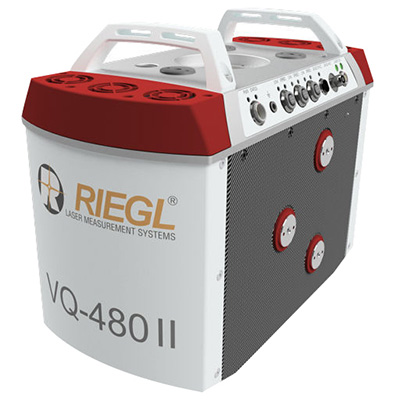
    The Riegl VQ-480 II and VQ-580 II are designed for airborne applications at mid-altitudes for use on both manned and unmanned aircraft. The new Mark 2 designs of previous models improve both performance and user-friendliness. Both offer a measurement rate of up to 1,250,000 measurements/second and a 75-degree field of view of suitable for corridor mapping, city modeling and applications in agriculture and forestry. Weighing approximately 10kg, they are ready for integration into helicopters and unmanned UAVs with a higher payload capacity. The VQ-480 II and VQ-580 II are prepared for smooth GNSS/IMU integration, offer interfaces for up to five optional cameras, and are have built-in and removable storage.The VQ-480 II works at a laser wavelength of 1550 nm; the VQ-580 II at the1064 nm wavelength suited to measure on ice and snow.

    Riegl, www.riegl.com

    UAV security

    Designed to protect outdoor events

    The portable DroneNode. (Photo: DroneShield)
    The portable DroneNode. (Photo: DroneShield)

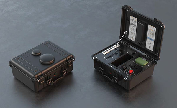
    DroneNode is a portable, compact and inconspicuous counter-drone jamming device that law enforcement can use at large outdoor events without raising public concern (it is not yet authorized for use in the U.S.) It can simultaneously jam 2.4 GHz, 5.8 GHz and GNSS L1 and L2 bands up to one kilometer, causing drones to return to their point of origin or land. It is also effective against swarm attacks. Emergency broadcasts, cellphone communication and other dedicated channels are unaffected.

    DroneShield, www.droneshield.com

    Action drone

    Follow drone with obstacle avoidance

    Photo: Skydio
    Photo: Skydio

    Skydio R1 users now have the ability to follow cars. New modes include Car Follow, improved Lead Mode, and other improvements throughout the system, which is built on top of the Skydio Autonomy Engine. The engine operates 13 cameras, enabling it to map and understand the world in real time, allowing it to be fully autonomous and independently capture video footage. Its Nvidia Jetsonl AI runs neural networks that trained for the Car Follow feature on datasets of automobile images.

    Skydio, www.skydio.com

  • Trimble displays OEM board family at Intergeo 2018

    Trimble’s Thomas Wunderlich discusses its BD990, BD992 and BD992-INS boards at Intergeo 2018, which took place place Oct. 16-18 in Frankfurt, Germany.

  • Trimble announces new geospatial products at Dimensions conference

    Trimble announces new geospatial products at Dimensions conference

    Trimble introduced several new geospatial products at its annual Trimble Dimensions user conference, which took place Nov. 5-7 in Las Vegas.

    The Trimble R4sLE GNSS receiver. (Photo: Trimble)
    The TrimbleR4sLE GNSS receiver. (Photo: Trimble)

    Forensics GNSS Solution. The Trimble Forensics GNSS solution combines the Trimble T10 tablet or TDC100 handheld with the Trimble Forensics Capture software and the Trimble R4sLE GNSS receiver.

    The solution enhances forensics fieldwork by improving efficiency and broadening the range of data collection technologies available using the same, proven software. Trimble Forensics Capture software supports GNSS-based workflows and works with the Trimble R4sLE receiver, or any Trimble R-series receivers. Options for data collection now include GNSS, 3D scanners, total stations and unmanned aerial systems.

    Trimble Forensics Capture software. (Image: Trimble)
    Trimble Forensics Capture software. (Image: Trimble)

    Key features:

    • Forensics Capture field software, designed with the help of law enforcement, uses industry terminology and Wizard-based workflows, making it easy to learn and easy to use.
    • Built-in ground scaling and local coordinate system for every scene so there is no need for site calibrations.
    • Integrated surveying workflows for GNSS, Trimble SX10 or total stations.
    • Storage for all collected data within the same Capture file, including GNSS, total stations or the SX10.
    • An IP-67 rated Trimble R4sLE receiver, which is protected from dust and capable of withstanding water immersion up to a 1 meter for 30 minutes.

    The new solution is expected to available in December 2018.

    Trimble Business Center v5.0. (Image: Trimble)
    Trimble Business Center v5.0. (Image: Trimble)

    New version of Business Center. Version 5.0 of Trimble Business Center merges two products, Trimble Business Center and Business Center – HCE, to provide both surveying and civil construction customers with a complete office software solution. Combining both products into one platform provides a larger set of tools and data interoperability between survey and construction workflows.

    New capabilities:

    • Support for mobile mapping and terrestrial scanning data from systems such as the Trimble MX9 mobile mapping system and the Trimble TX series terrestrial scanners.
    • Ability to combine high-quality flight data from Delair unmanned aerial systems (UAS) with other sensor data for the rapid creation of vivid orthomosaics and highly accurate surface models. Survey and construction professionals can now integrate these multi-sensor data types within the single software environment.
    • Intelligent new tools for the creation of computer-aided design (CAD) and geographic information system (GIS) deliverables, corridor inspection reports and tunnel as-built analysis from complex 3D point clouds.
    • The addition of automated feature extraction, powered by Trimble eCognition software, to dramatically reduce the time to extract features, such as trees, poles and signs, from point cloud data.
    • New multi-slice capabilities, combined with cutting plane workflows, which allow users to quickly extract cross sections from point clouds at intervals along a linear geometry, further streamlining corridor redesign and maintenance reporting.
    •  Trimble Macro Language (TML), which allows survey and construction professionals to customize data computations and add new CAD and GIS workflows to fit specific local requirements.

    New Versions of eCognition Software. Trimble’s eCognition is a software platform for advanced geospatial image analysis for environmental, agriculture, forestry and infrastructure applications.The software extracts accurate geo-information from remote sensing data; eCognition’s intelligent information extraction capabilities accelerate mapping, change detection and object recognition by delivering standardized and reproducible image analysis results.

    Updates:

    • eCognition Suite 9.4 — An improved data management and visualization user interface,  algorithms for common feature extraction operations and enhanced 3D data visualization to streamline the development workflow for automatic extraction of valuable information from images and point cloud data. The new capabilities increase the productivity of remote sensing specialists, GIS experts, cartographers, photogrammetrists and geospatial professionals.
    • eCognition Oil Palm Application 1.3 — A specific solution that provides oil palm plantation managers with valuable information from UAS data that enables them to efficiently manage the plantation. Version 1.3 introduces extended functionality to identify gaps within the plantation to maximize productivity and to enable more sustainable management.
  • Trimble announces new products at Dimensions conference

    Trimble announces new products at Dimensions conference

    Trimble introduced several new products at its annual Trimble Dimensions user conference, taking place Nov. 5-7 in Las Vegas.

    Photo: Trimble
    Photo: Trimble

    GNSS Smart Antennas for Civil Construction. The new SPS785 GNSS smart antenna is a fully capable GNSS receiver that features high-quality GNSS accuracy at a lower price point. The SPS785 has full satellite coverage with the combination of GPS and all GNSS constellations. A seamless workflow with the Trimble Siteworks Positioning Systems means that everyone on the jobsite can use the same data and work on the same platform.

    For added protection, the SPS785’s radio antenna fits inside the range pole. The lightweight and compact design enables contractors to work longer with less fatigue.

    Also, a new dynamic tilt functionality was added to the Trimble SPS986 GNSS smart antenna. The SPS986 is specifically designed for rugged jobsite measurement applications, and is now available with a dynamic tilt upgrade. The dynamic tilt feature allows for faster data collection to enable construction surveyors to create larger digital terrain models faster and with improved accuracy. It is designed to capture higher accuracy measurements on steeper slopes from a moving vehicle and more accurate volume measurements to save time and money on material planning.

    The dynamic tilt measurement mode also auto-measures antenna height. From inside the vehicle, contractors can set the height of the antenna and quickly interrogate surface models using the real-time 3D surface display in Trimble Siteworks field software.

    The Kestrel seismogeodetic system. (Photo: Trimble)
    The Kestrel seismogeodetic system. (Photo: Trimble)

    Kestrel Seismogeodetic System. Trimble RTX technology is now delivered via satellite to the Kestrel seismogeodetic system for earthquake, volcano and infrastructure monitoring. Designed for scientists and structural engineers, Trimble’s Kestrel pairs uninterrupted, high-quality GNSS positioning corrections with seismic data — for Earthquake Early Warning (EEW), volcano and infrastructure monitoring of bridges, dams, towers and other civil structures.

    In addition to internet-delivered Centerpoint RTX corrections, the Kestrel system also now supports L-band satellite delivered RTX corrections. This ensures corrections are not affected during communication delays or outages that occur during natural disasters. CenterPoint RTX enables centimeter-level absolute positioning, which is critical when analyzing and responding to the movement of a structure.

    Field Staking and Design Solution for Electric Utilities. Trimble Field Designer is an innovative mobile staking and design solution that enables electric utilities to quickly design overhead and underground electric utility lines on mobile devices in the field.

    Trimble Field Designer leverages mobile technology from Trimble business partner GeoSpatial Innovations, Inc. (GSI). It was developed to add new field staking and design capabilities to Trimble’s Network Information System (NIS), a network asset management solution. At the heart of Trimble NIS is a fully connected “live” network model built on a single database that provides for comprehensive documentation, topology and full life-cycle support of electric utility network assets.

    Trimble Field Designer enables electric utilities to:

    • Capture pole locations efficiently and accurately
    • Measure distances, angles, elevations, offsets, and bisectors
    • Assign construction units to locations and spans for material and labor requirements
    • Capture comments and information about design
    • Reduce design time
    • Eliminate redundant data entry in the office.

    Earthworks Grade Control Platform version 1.7. The latest version of Earthworks provides support for motor graders and automatic guidance for tiltrotator attachments. Trimble Earthworks for Motor Graders is a GNSS-based, 3D-grade control solution designed to make fine grading more accurate, faster and easier. In addition, Trimble Earthworks now gives excavator operators using tiltrotators the advantage of automatic machine control, which can result in increased productivity.

  • Trimble CenterPoint RTX, A Customer Story — Surveying in South Africa

    A video featuring a South African veteran surveyor, telling his story of achieving 2 cm horizontal accuracy with Trimble CenterPoint RTX. Satellite-delivered, survey grade accuracy and no base station required!

    Visit Trimble.com for more information.

  • Excavator makers provide smart options

    Excavator makers provide smart options

    The JCB 220X Excavator at work. (Photo: JCB)
    The JCB 220X Excavator at work. (Photo: JCB)

    Makers of heavy construction equipment are enabling their latest models to become smarter.

    Topcon Positioning Group and JCB are collaborating to provide the Topcon X-53x as a plug-and-play option for the new JCB 220X crawler excavators — the first models in the next generation of JCB tracked machines for the global construction market.

    The new excavators come with a Topcon pre-wire option from the factory. The Topcon X-53x is designed to provide precise positioning of the boom, stick and bucket at all times, maximizing output up to 30 percent more than machines without a 3D system, the company said. The X-53x also provides a customizable machine control platform to address future project demands.

    Also, Topcon and Volvo CE have established a system to allow Topcon 3D machine control software (3D-MC) to seamlessly integrate with the Volvo CE Dig Assist system for a large range of excavators.

    The integration of 3D-MC software is designed to complement the Dig Assist real-time guidance capability by including the use of 3D design files and connectivity with Topcon workflow solution platforms. Topcon 3D-MC can be added as an app on the Co-Pilot platform to connect the machine to the Topcon ecosystem.

    Meanwhile, Kobelco Construction Machinery has introduced a Trimble-ready option for select excavator models that ship from the Kobelco factory. The excavators come ready for installation of the Trimble Earthworks Grade Control Platform, reducing the cost and complexity of installation for the contractor. Other Kobelco models released this year will also provide the Trimble-ready option.

    Doosan Infracore is offering a Trimble-ready option for its Doosan DX225LC-5 excavator, enabling faster, simplified installation of Trimble’s GCS900 2D or 3D Grade Control System components with no welding, re-painting, drilling or disassembly required.

    Trimble GCS900 makes design surfaces, grades and alignments accessible to the operator on a display inside the cab using GNSS, GPS, laser, sonic or total station technology to accurately position the blade or bucket in real time.

  • OEM module makes light work of mapping

    OEM module makes light work of mapping

    The BYes “GetYourSpace” service collects and analyzes lighting in urban environments using a GIS-based approach and the Trimble MB-TWO GNSS module.

    One of the most visible services provided by cities and municipalities is the illumination of streets and public spaces. To optimize the use of public funds, cities need timely, comprehensive information on how their lighting systems are working. Operators use the data to monitor system performance and plan maintenance, repairs and upgrades.

    Gathering data on street lighting is often performed manually. Technicians carrying photometers and clipboards visit individual light poles to collect information on the lighting output. The work, which must be performed at night, is slow and labor-intensive and can pose safety issues for the field technicians.

    GetYourSpace debuts

    GetYourSpace platform: The white G-Nav smart antenna contains the Trimble MB-TWO GNSS module. (Photo: Trimble)
    GetYourSpace platform: The white G-Nav smart antenna contains the Trimble MB-TWO GNSS module. (Photo: Trimble)

    The French company Bouygues Energies & Services (BYes) provides solutions that help cities operate efficiently. The company recognized the need for a mobile, automated system to collect lighting data and produce results accessible by a variety of users.

    The opportunity evolved into the BYes “GetYourSpace” service, which collects and analyzes lighting and other facets of urban environments. It uses a GIS-based approach to provide mapping and visualization functions.

    BYes set out to develop a compact platform that could detect and measure sources and characteristics of light. To present information using GIS, the GetYourSpace platform needed to include reliable geolocation. BYes called on Cadden, a French developer of location systems for marine and industrial applications, to provide the positioning component for the GetYourSpace platform.

    Reliable geolocation

    MB-Two module by Trimble.
    MB-Two module by Trimble.

    For the GetYourSpace collaboration, Cadden proposed a version of its G-Nav smart antenna, a product from Cadden’s GEOD brand. The G-Nav is built around a Trimble MB-TWO compact OEM GNSS module, an advanced GNSS receiver in a compact form designed for easy integration. The MB-TWO provides a range of GNSS configuration options, which allowed Cadden to produce a positioning system tailored to the BYes requirements.

    The communications ability of the MB-TWO enabled Cadden to streamline the development process. The module provides multiple input/output options and can be configured and controlled using a web interface as well as a simple ASCII command set. Cadden leveraged the module’s small size and low power requirements to embed it into a compact, robust GNSS unit that combines power and data into a single connection.

    High-speed data collection

    Heat map of lighting data collected by GetYourSpace. Accurate geolocation is essential to producing easy-to-use results. (Image: BYes, Trimble)
    Heat map of lighting data collected by GetYourSpace. Accurate geolocation is essential to producing easy-to-use results. (Image: BYes, Trimble)

    Cadden’s implementation of Trimble GNSS provided key enabling technology for GetYourSpace. With an area of 1 square meter, the mobile platform includes the GNSS, light and environmental sensors, system controller and data logging.

    The MB-TWO rapid update rate (up to 50 Hz) enables the GetYourSpace platform to capture accurate information even while moving at high speed. The low-power, lightweight platform can be mounted on a small car or towed behind a bicycle and requires minimal interaction with the operator or driver.

  • Trimble RealWorks announces performance and UI enhancements

    Trimble RealWorks announces performance and UI enhancements

    Trimble will release a new version of Trimble RealWorks, its all-in-one point-cloud software platform. The new version of Trimble RealWorks — featuring performance and user interface (UI) improvements — will be available for download June 19.

    Changes include the following:

    • Batch processing workflows are now available to automate data processing for large datasets saving users time on projects.
    • New visualization and productivity tools include enhanced shading, improved registration automation and geometry editing. According to Trimble, the new tools enable customers to better understand project data and more easily create customer deliverables.
    • Enhanced multi-core processing for modern CPUs and added support for AMD Ryzen-based computers significantly reduces the processing time for registering and extracting scans.
  • MicroPilot, Trimble integrate GNSS into UAV autopilot

    MicroPilot, Trimble integrate GNSS into UAV autopilot

    MicroPilot Inc. has teamed with Trimble to integrate high-precision GNSS technology as part of its autopilot for guidance and control of unmanned aerial vehicles (UAVs).

    With centimeter-level, real-time kinematic (RTK) positioning capabilities, Trimble’s multi-constellation GNSS receivers are capable of tracking signals from GPS, GLONASS, Galileo and BeiDou, the company said. Trimble GNSS receivers are used in a wide variety of applications ranging from port automation and robotics to autonomous vehicle guidance.

    MicroPilot develops and manufactures autopilots for UAVs, including the triple-redundant MP21283X. The company also provides support products that enable customers to use their development time as efficiently as possible and bring their products to market faster. These products include the trueHWIL2 UAV autopilot simulator and the XTENDERmp software development kit.

    The MP21283X UAV autopilot. (Image: Micropilot)

    Working closely with Trimble gives MicroPilot the ability to better leverage Trimble’s GNSS technologies. This access improves the ability of MicroPilot’s support team to assist customers with their product development, testing and operations. Trimble will benefit from MicroPilot’s extensive experience integrating guidance, navigation and control systems for a wide variety of UAV platforms, the companies said.

    “Reliable, robust and innovative GNSS solutions as well as strong technical support is key to bringing any UAV to market and our relationship with Trimble will allow MicroPilot to improve on our already industry-leading support,” said MicroPilot president Howard Loewen.

    “We are very pleased to be working closely with MicroPilot to provide high-precision GNSS for its UAV autopilot solutions,” said Joseph Carey, director of strategic initiatives for Trimble’s Integrated Technologies Division. “MicroPilot autopilot’s simple installation, configuration and customization capabilities allow UAV manufacturers to easily integrate reliable, state-of-the-art, professional guidance, navigation and controls to their aerial platforms.”

  • AUVSI Xponential: Major GNSS players exhibit new UAV products

    AUVSI Xponential: Major GNSS players exhibit new UAV products

    The Association for Unmanned Vehicle Systems International’s (AUVSI’s) Xponential 2018 show took place in Denver April 30-May 3. The event convenes the global community of commercial and defense leaders in intelligent robotics, drones and unmanned systems.

    AUVSI Xponential was a big show once again — 8,500 attendees, more than 600 exhibitors, 200 educational sessions and 400 speakers. The show floor was huge as usual, with virtually every kind of UAS product and service imaginable for inspection at small, large and larger booths or display areas.

    The morning kick-off presentation on Tuesday was enthusiastic about the coming large-scale adoption of drones and associated robotic technology, with a couple of real-time examples — driverless vehicles at Babcock Ranch in Florida and drone supply deliveries for humanitarian aid in Rwanda.

    A view of show floor.

    However, there still remain a number of barriers to wide-scale integration of drones into daily life from a regulation perspective, as Steven Bradbury, general counsel of the U.S. Department of Transportation, pointed out — while at the same time also indicating that the Federal Aviation Administration (FAA) has granted hundreds of waivers where the safety case has been adequate for lots of commercial UAS operations.

    Most of the major GNSS players were exhibiting at the show, so we focused on gathering their news while also collecting a flavor of the many drone system suppliers in attendance.

    U-blox introduced its new ZED-F9P multi-band, multi-constellation chip — with GPS, GLONASS, Galileo and BeiDou signal reception and processing and on-chip multi-band RTK with fast convergence times — promising centimeter-level accuracy and low 85 mA (4x GNSS) power consumption in a 17 mm x 22 mm package.

    ZED-F9P signals: coverage added in two stages. Option A – available now. Option B – available Q2/2020.

    Initial urban testing in Finland in challenging conditions has indicated RTK performance at 9 cm 94%, with high availability, short convergence times (<10 seconds) and fast reconvergence. This kind of performance is apparently initially targeted at automotive applications — u-blox is a member of the Sapcorda automotive group — and is forecasting samples for this July, with production beginning before the end of this year.

    The NovAtel tagline for the show was “Assured PNT,” which matches many U.S. and International agency objectives — this was accompanied by several announcements for both commercial and government agency products and applications.

    NovAtel’s new PwrPak7D.

    For UAV and other commercial applications, NovAtel has introduced several small-sized OEM7 based products, including the PwrPak7D (GNSS only) and PwrPak7DE1 (GNSS + Epson G320N MEMS IMU) — both dual-antenna heading capable, multi-frequency packages.

    The integrated E1 package includes NovAtel’s SPAN technology, which optimizes positioning and attitude performance during extended GNSS outages. Both new PwrPak enclosures come with the Interference Toolkit advanced interference detection and mitigation capability.

    With most UAVs, the electronics on the airframe can produce a disruptive internal interference environment, and can lead to potential problems for the integration of sensitive GNSS. To help overcome this issue, NovAtel has released the OEM7600 receiver board in an extremely small form factor, enclosed with protective shielding to reduce the effects of emissions from nearby electronics.

    The 7600 comes with 555 channels, multi-frequency/constellation positioning; L-band support for TerraStar corrections; serial, USB, CAN and Ethernet interfaces; advanced interference detection and mitigation features; RTK; GLIDE and Steadyline firmware options with 20-g vibration rating and the option to add integrated SPAN GNSS + inertial.

    NovAtel also announced Inertial Explorer Express, which provides the same core processing and utilities as Waypoint Inertial Explorer software for applications including unmanned aerial vehicles (UAVs) and smaller projects. Inertial Explorer Express will produce centimeter-level position and attitude solutions for lidar, camera and other sensor data with faster processing times and reduced complexity.

    On the government/agency business side of the house, NovAtel has been quite successful with the GAJT antenna, which includes integrated anti-jam technology. GAJT is in use operationally and has been shipped to 16 allied nations around the globe, with the latest success being with the artillery Observation Post Vehicles (OPV) for the Canadian Army.

    Canadian OPVs are used on the front-line of combat, so its essential that their location and timing information should not be compromised by enemy jammers. The NovAtel GAJT is readily retrofitted to existing vehicles to provide the necessary jamming defense needed by front-line forces.

    Previously, NovAtel also announced the selection of GAJT for the UK fleet of Type 26 Frigates – providing essential anti-jam protection for its onboard navigation system.

    MB-Two module by Trimble.

    Chris Wheeler and Omar Subra were good hosts when we visited them at the Trimble booth — Chris first made a YouTube video for GPS World (see below) and then gave me some insights into what’s new.

    Basically, the OEM line has rolled over new versions of almost all individual receiver boards, with the addition of the BeiDou B3 frequency, capability for RTX PPP (precise point positioning) corrections, the addition of new constellations and inertial integration options.

    An updated MB-Two receiver module can be configured for single frequency GPS through to dual frequency GPS, GLONASS, QZSS, Galileo and Beidou, uses RTX PPP and has an improved RTK engine for cm positioning from a base-station, or from over-the-air RTK corrections, or provides relative RTK against a moving base.

    A typical Trimble application could include capturing an Insitu ScanEagle UAV in a difficult shipboard multipath environment with integrated GNSS-inertial, UAV navigation and control, UAV payload stabilization, or providing a “truth-system” for autonomous unmanned ground vehicles.

    Since last year when Trimble introduced a “cell-phone” software receiver application, one useful application could have involved an insurance company using a “pocket-carried” antenna (with integrated RF) for field incident assessments. The cell-phone software license would be transferable to other assessors in the department, while a few pocket antennas are available for the whole assessment crew. This saves purchasing a whole load of hardware, and being limited to where the functionality can be moved or deployed. Everyone has a cell phone, and the relatively inexpensive antenna/RF can be available to all needing them.


    Watch this video to learn about Trimble’s latest products, including its BD990 and BD992 GNSS receiver boards.


    Trimble is also ramping up its OEM customer service and repair capabilities to improve turn around for multiple customers and applications in the field. Improved results are beginning to help customers and its OEM business, while increased R&D investment is expected to put new products into the field in the fall.

    This year Intel’s emphasis continued to be on how to manage the huge amount of data that high-precision visual and multi-spectral cameras are gathering by UAVs carrying out asset inspections for their customers. The Intel view is that this data is useless to an end-user unless it is interpreted and presented in a format that can be readily understood and used for the purpose it was intended.

    Let’s say a company operates 75 drones inspecting installations it owns or operates across several states, and that 50 GB of data is the nominal amount of data each drone collects on each mission. That means that nearly 4 TB of data could be collected daily if all 75 drones operate at once. More likely, over 1 TB daily shows up in a central location — a huge amount of unprocessed data.

    In a live demonstration, Intel showed how a typical installation inspection — by a drone taking high-resolution still photos at a remote location – could be collected and managed. Once in an Intel processing environment, the data quickly became visual format in 2D or 3D, and could be accessed remotely by an inspection team, saving significant travel costs and time to actionable results.

    Intel also promised to soon exceed its record at the Pyeongchang Winter Olympics for the number of drones flown at once — currently set at 1,218 drones. The company’s next target is for a light display using 1,500 multi-colored drones.

    Insitu CEO Esina Alic

    Insitu held a media event at the show to announce its ScanEagle-3 drone system. Esina Alic, the new Insitu CEO, led a team who introduced and then unveiled the new commercial-standard ScanEagle variant.

    This new variant has grown out of 20 years of experience and 15 years of working with the FAA to enable integration of drones into the U.S. National Airspace System (NAS). The ScanEagle-3 (SE-3) has been rebuilt with the objective of developing a certifiable vehicle with increased payload and endurance capability that is free of any ITAR restrictions — allowing export without restrictions to the rest of the world.

    Insitu unveils the ScanEagle-3 is at Xponential 2018.

    SE-3 features include:

    • Significantly increased (x2) payload
    • Still provides for full integration of all existing payloads
    • Commercial, non-ITAR product for the global market
    • Long-endurance platform
    • Service contracts available
    • Product release in Q2 2019
    • Fully compatible with existing launch and recovery systems
    • Around ~100 lb without payloads

    ScanEagle variants were used in emergency response to the California wildfires at Santa Rosa and Medicina, gathering real-time information for fire-line combatants.

    ScanEagle helped fight these wildfires using High Accuracy Photogrammetry (HAP) sensors. Military-grade electro-optical (EO) cameras during daylight and infrared (IR) cameras for night-time imaging extended the time available for tracking fire lines. Penetrating smoke or darkness, these UAVs gathered video and still images that were used to create geo-referenced, high-resolution digital fire progression and suppression maps to guide firefighting on the ground.

    ScanEagle helped firefighters battle blazes in California in September 2017. (Image: © Reuters)

    Summary

    This small overview of Xponential 2018 attempts to provide a flavor of the breadth of activity we saw at the show last week. A good portion of this has also been captured through short videos published on the GPS World website, along with news articles.

    There is more to come, with a report to follow from the show on Septentrio’s new product releases, Spirent’s GNSS simulation demo, DJI’s overview of drone products featured at the show, CyPhy Works tethered drones, Swift’s announcement of its Skylark correction service trials, Hemisphere’s new Vector Smart Heading Antenna, and Harxon’s antennas for drones.

    A big show to cover, that’s for sure! It’s a good sign that people were perhaps talking more business than in previous years and a sign that the UAS industry is perhaps moving into its next growth phase.

  • Trimble presents GNSS receiver boards at Xponential 2018

    Trimble’s Chris Wheeler offers an overview of Trimble’s GNSS technology, including its latest receiver boards, which include the BD990 and BD992, at Xponential 2018 in Denver.

  • Trimble launches TSC7 controller and apps for surveyors

    Trimble has released the Trimble TSC7 controller, a new field solution for land and civil construction surveyors. The TSC7 brings powerful enhancements to the field and was designed based on customer feedback, the company said. It provides a tablet experience with a physical keyboard and a sunlight readable 7-inch touchscreen that supports pinch, tap and slide gestures.

    Users can interact with the TSC7 intuitively, easily zooming, panning and selecting items on the large touchscreen. Front- and rear-facing cameras allow users to video conference their office from the field for on-the-job support, and capture high-definition videos and images that provide valuable context to their data and clients.

    Trimble TSC7 controller.

    The TSC7 also leverages the power of Windows 10 Professional, driven by an Intel Pentium 64-bit quad-core processor. The processor and operating system make it easy to process data in spreadsheets and run office software programs. An ergonomic form factor, IP68-certified rugged design and optional, user-interchangeable modules make the TSC7 a flexible solution for all surveying applications.

    Trimble also announced a new version of its field software, Trimble Access 2018. The software features a new user interface and powerful graphics capabilities to deliver enhanced workflows for field surveyors.

    Access 2018 has been redesigned with even more intuitive menus and screen navigation to take advantage of the TSC7’s 7-inch touchscreen and computing power, while leveraging software workflows, which include applications for general survey, roading, tunnels and pipelines.

    Access 2018 also integrates with the Trimble Sync Manager application to enable cloud-based data management between the office and the field. Surveyors can quickly start working by downloading preconfigured jobs in the field with DXF maps and CSV files linked ready to start surveying. Sync Manager also integrates seamlessly with Trimble Business Center software and is compatible with other industry office software platforms.

    https://youtu.be/I2oMLIvu3Ck

    “Today’s surveyors are managers of geospatial intelligence,” said Ron Bisio, vice president of Trimble Geospatial. “Data has more depth and complexity than ever before, and surveyors’ reputations depend on transforming that data into valuable, reliable information for their clients. The TSC7 and Access 2018 form the new backbone of our field solutions ecosystem, and give our users a leading edge to be data experts.”

    Rover Systems

    Trimble is also releasing two new rover systems for civil engineering and construction applications — the Trimble Siteworks Positioning System for Construction Surveyors and the Trimble Siteworks Positioning System for Supervisors.

    Both systems feature new Siteworks Software, next-generation survey software tailored for construction workflows. Completely redesigned from the ground up, Siteworks Software features a new interface that is optimized for ease-of-use and productivity. Configurable views, colorful graphics and natural interactions and gestures make Siteworks software intuitive and easy to learn.

    Siteworks Positioning System for Construction Surveyors is comprised of the Trimble SPS986 GNSS smart antenna, the TSC7 controller and Siteworks software. It enables construction surveyors to work with complex 3D models, collect large data sets faster, visualize complex 3D models more easily and work day or night efficiently.

    Siteworks Positioning System for Supervisors is comprised of the SPS986 GNSS smart antenna, the Trimble T10 Tablet and Siteworks software. It enables construction supervisors to run full office software packages, including Business Center – HCE and Microsoft Office, and to work easily with data and 3D models in the field without carrying a laptop.

    The Trimble TSC7 Controller running the current version of Trimble Access field software will be available worldwide in May through Trimble’s Geospatial distribution partners.

    The Access 2018 beta program will open to applicants in early May.