Tag: U.S. Space Force

  • China’s BeiDou challenges US GPS dominance

    China’s BeiDou challenges US GPS dominance

    Image: imaginima/iStock/Getty Images Plus/Getty Images
    Image: imaginima/iStock/Getty Images Plus/Getty Images

    Fifty years since it was designed and approved by the U.S. Department of Defense (DOD), the GPS is at risk of losing its status as the world’s gold-standard location service, reported The Wall Street Journal.

    In a recent paper published by Harvard’s Belfer Center for Science and International Affairs, “China’s BeiDou: New Dimensions of Great Power Competition,” Sarah Sewall, executive vice president for strategic issues at IQT and co-authors Tyler Vandenburg and Kaj Malden outline their finding that China’s version of GPS is part of the country’s longstanding effort to join the technological ranks of leading nations and use its capabilities to achieve geopolitical advantage across the globe.

    Sewall’s assessment of BeiDou’s technical superiority received some unexpected support from a government advisory board on GPS, which stated that “GPS’s capabilities are now substantially inferior to those of China’s BeiDou,” and urged the administration to regain U.S. leadership in the field.

    The BeiDou constellation is newer and has more satellites than any other system and has more than ten times as many monitoring stations around the world than GPS does. As a result, BeiDou’s accuracy is much better in many places, including the developing world.

    Sewall points out that in cases where BeiDou provides the most accurate positioning, navigation, and timing (PNT) data, particularly in the global south, China may be able to influence other nations’ economies, stating that it is one example of “a new form of great power competition that most in the U.S. government don’t recognize.” China is providing superior PNT information to enhance its diplomatic, economic and military power and the United States cannot afford to cede this area of longstanding advantage.

    BeiDou being newer and more advanced than other GNSS, makes it easier for China to encourage other nations to use its signals and purchase specialized equipment, especially when equipment purchases are heavily subsidized by the Chinese government, harming the U.S. economy and its status as the leader of GNSS technology.

    Recent launch and surveillance fears

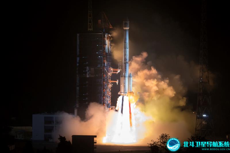
    On May 16, 2023, China launched its most recent BeiDou satellite to replenish the constellation, bringing its total to 56 satellites, nearly twice as many as the 31 GPS satellites.

    The latest BeiDou satellites also feature two-way messaging, a feature that GPS does not have. It is mainly available in China and requires special chips that are not widely available in the consumer market. It enables users to send short messages in areas without ground network cell coverage and can be used for search and rescue operations.

    The CNBC report noted the fear that, with its most recent enhancements, the BeiDou system could be used as a surveillance device — as the two-way messaging feature reveals a user’s locations as well as other types of data.

    Additionally, with the growing number of applications for cellphones and an increase in autonomous vehicles that use the BeiDou system, more and more user data is being transmitted.

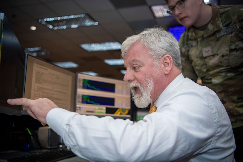
    The U.S. military is upgrading GPS with more-modern satellites that are designed to give nonmilitary devices more-precise coordinates in more indoor and hard-to-reach spaces. However, the next-generation GPS service for civilians is not expected to be released for several years.

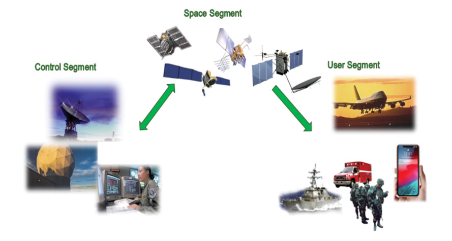
    GPS pioneered the PNT industry by offering civilians a new, free-to-use system. While originally developed for DOD, it turned into a critical global infrastructure that underlies a vast swath of the U.S. economy.

    Besides GPS and BeiDou, there are two other global navigation satellite systems (GNSS), Russia’s Glonass and the European Union’s Galileo, as well as regional systems from Japan (QZSS) and India (NavIc).

    BeiDou, once a small regional network with clunky receivers and few civilian users, has grown significantly since launching its first two satellites in 2000. It now has more than 30 precision-enhancing monitoring stations and claims to pinpoint users’ locations to within several centimeters, along with offering basic two-way communication capabilities.

    Both BeiDou and GPS offer a variety of nonmilitary benefits that expand beyond the systems’ original expectations, from Uber drivers who often rely on a smartphones GNSS data to locate customers to farmers who can use GPS-based applications for farm planning, field mapping, solid sampling and more. GPS has been called “the silent utility” because signals are used in almost every technology, said Dana Goward, president of the Resilient Navigation and Timing Foundation.

    Looking forward 

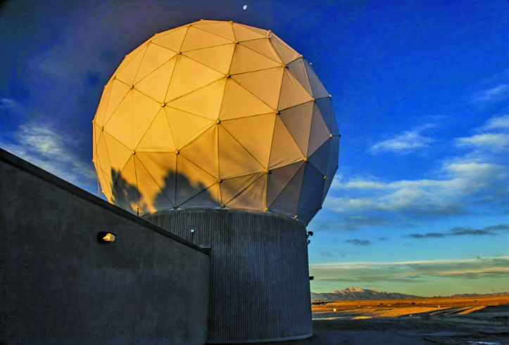
    GPS guides U.S. missiles, ships and troops through more-secure military frequencies kept separate from its civilian signals. Its past dominance even made rival militaries reliant on the Pentagon-controlled system.

    The U.S. military has long planned to upgrade GPS with a fleet of modernized and upgradable satellites that provide more-precise coordinates subject to less interference. The newer satellites broadcast data to civilian users over a new frequency called L5.

    The Space Force has 17 L5-equipped satellites in orbit after a series of delays  but has yet to reach the 24 live satellites needed to run a reliable system. Some already-built satellites sit in a Colorado warehouse awaiting their turn for a funded launch.

    The Space Force said in a statement that GPS continues to set the gold standard in its field.

    “While other nations may report improvements in accuracy and equivalent performance in availability, GPS is still the clear leader in integrity and is the only system accepted for international flight use,” a spokeswoman for the branch’s Space Systems Command told The Wall Street Journal.

  • Meet the SSC GPS Certifications Branch

    Meet the SSC GPS Certifications Branch

    Image: SSC
    Image: SSC

    The United States Space Force’s Space Systems Command (SSC) has a specialized branch responsible for certifying GPS accuracy called the GPS Certification Branch. It is a specialized team within SSC that is responsible for certifying the hardware, software, and firmware used in GPS-based systems.

    The certification process conducted by SSC’s GPS Certification Branch involves the evaluation of design and testing for various components of GPS-based systems. This includes user equipment — the devices used by individuals or organizations to receive GPS signals and determine their precise location.

    The GPS Certification Branch works with GPS manufacturers, agencies of the U.S. Department of Defense (DOD), and others to establish and maintain certification standards. Collaboration with industry experts, research institutions, and other certification bodies is also an important aspect of the branch’s work to stay informed about technological advancements and ensure the certification process remains up to date with the latest developments.

    The certification process also includes space segments — the satellites that transmit the GPS signals, monitoring stations, which track and monitor the performance of the GPS satellites, and the terrestrial modules — that provide end user secured and accurate signals.

    Certification of hardware, software, and firmware is critical to ensure that GPS systems meet the standards set by the DOD. This certification ensures that the GPS-based systems used by the military and other DOD agencies are reliable, accurate, and secure. It also ensures that they are interoperable and compatible with other military equipment and communication networks.

    The assessment process conducted by the GPS Certification Branch involves thorough testing and analysis of the design, performance, and security of the GPS components. This includes assessing the hardware’s ability to receive and process GPS signals accurately, the software’s ability to interpret and utilize the GPS data effectively, and the firmware’s ability to maintain system integrity and security.

  • ION GNSS+ 2023: Day two recap

    ION GNSS+ 2023: Day two recap

    ION GNSS+ 2023 is underway at the Hyatt Regency Denver at Colorado Convention Center. On the second day, industry leaders and show attendees gathered for the 63rd meeting of the Civil GPS Service Interface Committee. During a break, a cake was wheeled out to celebrate 50 years of GPS. GPS World staff wanted to highlight some key parts of the event.

    (Image: Matteo Luccio)

    (From left to right) Rick Hamilton, GPS Info Analysis Team Lead, U.S. Coast Guard; Harold “Stormy” Martin, Director, National Coordination Office for Space-Based Positioning, Navigation, and Timing; Dr. Bradford Parkinson, Edward Wells Professor, Emeritus, Aeronautics and Astronautics (Recalled), Co-Director, Center for Position, Navigation and Time, Stanford University; Capt. Scott Calhoun, Commanding Officer, U.S. Coast Guard Navigation Center (NAVCEN) and Karen Van Dyke Director, PNT and Spectrum Management, U.S. Department of Transportation, gathered around a cake to celebrate the 50th anniversary of GPS.

    Image: Matteo Luccio
    Image: Matteo Luccio
    Image: Matteo Luccio
    Image: Matteo Luccio

    A closer look at the 50 years of GPS cake. Learn more about the history of GPS here.

    Image: Matteo Luccio
    Image: Matteo Luccio

    Lt. Colonel Robert Wray, Commander, Second Space Operations Squadron, U.S. Space Force (second from left), who was featured on the May cover of GPS World. Click here to read our May cover story, featuring an exclusive interview with Lt. Colonel Wray about the training and duties of his team, the challenges they face, and more.

    Image: Matteo Luccio
    Image: Matteo Luccio

    Dr. Bradford Parkinson (left) and Dr. Robert Hampshire, Deputy Assistant Secretary of Research and Technology and Chief Science Officer, U.S. Department of Transportation (right). Click here to learn more about Dr. Bradford Parkinson, who is nicknamed “The father of GPS.”

    Image: Matteo Luccio
    Image: Matteo Luccio

    Col. Andy Menshner, GPS Space and Ground (SML), Space Systems Command, U.S. Space Force, speaking about GPS acquisitions and development updates during the Civil GPS Service Interface Committee.

    Image: Matteo Luccio
    Image: Matteo Luccio

    (Second from left) Karen Van Dyke, Director, PNT and Spectrum Manager, U.S. Department of Transportation Deputy Chair, serves as chair of the 63rd Civil GPS Service Interface Committee. Read more from the Department of Transportation here.

    Image: Matteo Luccio
    Image: Matteo Luccio

    Attendees gathered to hear speakers from the U.S. Department of Transportation, the U.S. Space Force, and other departments and agencies.

    Click here to stay up to date with our show coverage!

  • China threatens U.S. GNSS dominance

    China threatens U.S. GNSS dominance

    Photo:
    Image: Nikada/E+/Getty Images

    A report by CNBC — based on a paper published by Harvard’s’ Belfer Center for Science and International Affairs and written by Sarah Sewall — noted a growing concern that China’s BeiDou is technologically superior to GPS and serves much of the population better.

    Experts in the CNBC report explained that BeiDou supports China’s military ambitions, has spurred economic growth in the country, and has increased its diplomatic leverage.

    The first BeiDou satellite was launched in 2000 and served only mainland China. The system now consists of 45 operational satellites with 30 of them being the latest generation BDS-3 satellites.

    Image: Bedou.gov
    Image: Bedou.gov

    In 2020, China launched the last BeiDou satellite, completing the constellation. Since then, the influence of BeiDou has grown, with an estimated 1.1 billion people now using the system.

    One feature in the latest BeiDou satellites is two-way messaging that is mainly available in China and requires special chips that are not widely available in the consumer market. It enables users to send short messages in areas without ground network cell coverage and can be used for search and rescue operations.

    Surveillance fears

    The CNBC report noted the fear that, with its enhancements, the BeiDou system could be used as a surveillance device — as the two-way messaging feature reveals a user’s locations as well as other types of data.

    Additionally, with the growing number of apps for cellphones and an increase in autonomous vehicles that use the BeiDou system, more and more user data is being transmitted.

    The bottom line

    Satellites in the United States’ GPS constellation do not yet have those kinds of features.

    There are 31 operational GPS satellites, 6 of which are GPS III satellites.

    Image: GPS.gov
    Image: GPS.gov

    GPS satellite modernization 

    In 2008 Lockheed Martin beat out Boeing — the manufacturer of older GPS satellites — to build the GPS III satellites, the last of which was delivered in February. GPS III satellites deliver enhanced performance through a variety of improvements, including increased signal protection with improved accuracy.

    GPS III SV07, SV08, SV09 and SV10 (SV stands for “space vehicle”) are awaiting launch at Lockheed Martin’s GPS III processing facility in Waterton, Colorado.

    Lockheed Martin is now working on 22 GPS IIIF satellites — contracted in 2018 — that will feature more advanced capabilities. These satellites are expected to launch in 2026.

    The U.S. Space Force exercised its second contract option valued at approximately $737 million for the procurement of three additional GPS IIIF space vehicles from Lockheed Martin on Oct. 22, 2021. This contract option is for GPS IIIF satellites 15, 16 and 17 (SV15-17).

    The entire fleet of GPS satellites is expected to be modernized in 2032 or 2033. However, for now, President Biden’s National Space-Based Positioning Navigation, and Timing (PNT) Advisory Board recognizes the need for a resilient national PNT architecture and acknowledges that BeiDou is technologically superior to GPS.

  • First Fix: Still waiting for M-Code

    First Fix: Still waiting for M-Code

    Max Weber famously described how bureaucratic inertia often leads formal organizations, such as government agencies, to devise new justifications for themselves after they have outlived their original purpose. That is certainly not the case for the U.S. Space Force, which is in its infancy and is responsible for key missions, including operating the Global Positioning System that it took over from the United States Air Force about two years ago.

    However, bureaucratic inertia can also refer to the tendency of organizations to continue to pursue projects or approaches that may no longer be the best match for their goals, missions, or budgets. A recent, congressionally-mandated report by the United States Government Accountability Office (GAO) — Report to Congressional Committees, GPS MODERNIZATION: Space Force Should Reassess Requirements for Satellites and Handheld Devices, issued in June — questions the Space Force’s approach to modernizing GPS with a more jam-resistant, military-specific signal known as M-code.

    In 2005, the Air Force launched the first GPS satellite capable of broadcasting the M-code signal, which is at the core of a multi-billion-dollar modernization and sustainment effort. Yet, 18 years later, widespread adoption of the technology is still hampered by delays in upgrading GPS ground and user equipment. Approximately 700 types of weapon systems — including ground vehicles, ships and aircraft — will ultimately require M-code-capable user equipment.

    Providing M-code requires the cooperation of GPS’ ground, space and user equipment segments. Regarding the first one, the report states: “In 2022, Space Force further delayed delivery of the ground control segment due to development challenges. This delay pushes delivery until December 2023 at a minimum. Space Force officials have not finalized a new schedule and acknowledged that remaining risks could lead to additional delays.”

    Regarding the space segment, it states: “Space Force met its approved requirement for 24 M-code-capable satellites on orbit but determined that it needs at least three more to meet certain user requirements for accuracy. Building and maintaining this larger constellation presents a challenge. GAO’s analysis indicates it is not likely that 27 satellites will be available on a consistent basis over the next decade.”

    Finally, regarding the user segment, it notes that development of the Military GPS User Equipment (MGUE) Increment 1 has progressed “to the point where the military departments are ready to commence activities in support of testing and fielding it on the lead weapon systems.” However, it cautions that “[d]elays and unexpected challenges could affect the fielding of capability for some systems.”

    GAO’s report recommends that the United States Department of Defense (DOD) assess the number of GPS satellites necessary to meet operational needs, and either develop a sound business case for the M-code-capable Increment 2 handheld, or not initiate the effort. The DOD concurred with both recommendations.

    Who Runs GPS?”, the special feature in our February 2023 issue, which detailed the structure of this vast enterprise, listed an executive committee, a coordination office, an oversight council, two Space Force commands, and, as partners, several federal departments and agencies. Has this complex structure become too diffuse to make tough decisions?

    Matteo Luccio | Editor-in-Chief
    [email protected]

  • Talking to the satellites

    Talking to the satellites

    On the operations floor of the GPS Master Control Station at Schriever Space Force Base in Colorado, Luccio looks at feeds from a worldwide network of monitor stations and ground antennas. (Image: U.S. Space Force photo by Dennis Rogers)
    On the operations floor of the GPS Master Control Station at Schriever Space Force Base in Colorado, Luccio looks at feeds from a worldwide network of monitor stations and ground antennas. (Image: U.S. Space Force photo by Dennis Rogers)

    The young operators on duty at the GPS Master Control Station, at Schriever Space Force Base in Colorado, receive feeds from a worldwide network of monitor stations and ground antennas, monitor the GPS satellites, and send them commands as needed. This month’s cover story features excerpts of an interview with their commander, Lt. Col. Robert O. Wray, about the training and duties of his team members, the challenges they face, and what brought him to his current assignment.

    Also in this month’s cover story a Q & A with Spirent Federal Systems on how simulation supports GPS modernization and one with Hexagon | NovAtel on the company’s anti-jamming antennas.

    Check out the three Q&A’s featured in this cover story:

    GPS Master Control Station

    Spirent Federal

    Hexagon | NovAtel 

  • First Fix: Controlling the constellation

    First Fix: Controlling the constellation

    Image: U.S. Space Force photo by Tiana Williams
    Image: U.S. Space Force photo by Tiana Williams

    Colorado Springs, Colorado, and its vicinity are home to several key U.S. military organizations.

    To the northwest is the U.S. Air Force Academy, which educates cadets for service in the officer corps of the United States Air Force and United States Space Force.

    To the southwest, deep inside Cheyenne Mountain, is the North American Aerospace Defense Command (NORAD), a United States and Canadian organization charged with detecting, validating and warning of attacks against North America, whether by aircraft, missiles, or space vehicles. In a crisis, the four-star general in command of NORAD would pick up a direct line to the White House and tell the president whether nuclear armed missiles were on their way to the United States. He also commands the United States Northern Command, which is charged with defending the continental United States and Alaska.

    I visited these two facilities 35 years ago, when I was a graduate student in international security at MIT. (The Air National Guard flew our group of MIT and Harvard students from Hanscom Air Force Base, near Boston, to Colorado Springs, with a stop at Offutt Air Force Base, home of the U.S. Strategic Command. One of the first Northrop B-2 Spirit, aka the Stealth Bomber, was there, under a tarp. A Harvard student decided to use the stop to go for a run. The MPs promptly arrested him and his professor had to bail him out, much to the amusement of us MIT students.)

    In the southeast corner of the city is Peterson Space Force Base. To the east is the one that is of greatest interest to readers of this magazine: Schriever Space Force Base, the home of the GPS Master Control Station.

    I recently visited the MCS at the invitation of Lt. Col. Robert O. Wray, Commander, 2nd Space Operations Squadron, which operates it. You can read excerpts of my interview with him here.

    Wray gave me a tour of the MCS operations floor. During the tour, I was able to look at the dozens of computer monitors used by the GPS operators and to ask them many questions about their jobs. At any moment, 10 of them are on duty — eight uniformed military personnel and two civilian contractors. Later, I followed up with two members of the GPS Warfighter Collaboration Cell, which supports warfighters, combatant commands and, through the U.S. Coast Guard Navigation Center, more than four billion global civilian users.

    Near the end of the tour, Wray surprised me with a question: “Would you like to send a command to a GPS satellite?” You can imagine my prompt answer. A moment later, I was seated at one of the consoles and entering an alpha-numeric string that I was copying from one of the screens. I was so delighted by the opportunity and so focused on entering the sequence correctly that I forgot to ask what command I was sending! Whatever it was, I assume it will help you get to your destination.

    Matteo Luccio | Editor-in-Chief
    [email protected]

  • NTS-3 satellite to launch this year

    NTS-3 satellite to launch this year

    The Navigation Technology Satellite–3 (NTS-3) — designed, built and tested by L3Harris — is on track to launch this year. The experimental satellite aims to shape the future of U.S. positioning, navigation and timing capabilities and to help U.S. forces to operate in GPS-denied environments and areas prone to spoofing.

    NTS-3 minimizes the impacts of GPS jamming through rapidly reprogrammable signal waveforms, frequency agility and increased signal strength. Its embedded software and firmware are reprogrammable on-orbit.

    When paired with reprogrammable receivers, the U.S. Air Force and U.S. Space Force can react in real time as threats evolve on the battlefield. In addition, NTS-3 has enhanced processors to support more complex signals.

    In January, L3Harris delivered the NTS-3 vehicle to Kirtland Air Force Base, New Mexico, to prepare the satellite for launch. The Air Force Research Laboratory and L3Harris are working together to complete space vehicle testing, launch vehicle integration and enterprise integration to confirm compatibility between the control segment, ground receivers and the satellite vehicle.

    NTS-3 is scheduled to launch later this year aboard United Launch Alliance’s Vulcan Centaur rocket. Once launched, NTS-3 will remain in a near-geosynchronous orbit for an inaugural year of testing.

  • Who are the GPS operators? What do they do?

    Who are the GPS operators? What do they do?

    Lt. Col. Robert O. wray commands the 2nd Space Operations Squadron (2 SOPS), which operates GPS around the clock supplemented by members of the 19th Space Operations Squadron (19 SOPS). (Credit: Dennis Rogers)
    Lt. Col. Robert O. wray commands the 2nd Space Operations Squadron (2 SOPS), which operates GPS around the clock supplemented by members of the 19th Space Operations Squadron (19 SOPS). (Credit: U.S. Space Force photo by Dennis Rogers)

    Exclusive GPS World interview with the commander of the unit that operates the GPS constellation

    The entire Global Positioning System constellation comprised of 38 satellites — with its billions of users and myriad military, commercial, consumer and scientific applications — is controlled from one room in a gray office building on a small military base about nine miles east of Colorado Springs, Colorado. The base is Schriever Space Force Base (SFB) and the room is the “operations floor” of the GPS Master Control Station (MCS). It is staffed by members of the 2nd Space Operations Squadron (2 SOPS), an active-duty unit of the U.S. Space Force, supplemented by members of the 19th Space Operations Squadron (19 SOPS), a unit of the U.S. Air Force Reserve. The two squadrons are known collectively as “Team Blackjack.

    Lt. Col. Robert O. Wray is the commander of 2 SOPS and of those 19 SOPS members assigned to the MCS. On March 16, at Schriever SFB, Wray spoke at length with GPS World’s editor-in-chief, Matteo Luccio, about the training and duties of his team members, the challenges they face, and what brought him to his current assignment. He then gave Luccio a tour of the MCS and introduced him to each of the 10 people on duty. At any given time, eight of these operators are military personnel and two are civilian contractors. They receive feeds from a worldwide network of monitor stations and ground antennas, including telemetry from the satellites, that enable them to precisely monitor the satellites’ orbits and the state of their systems. The operators upload data and commands to the satellites around the clock to keep the constellation fine-tuned and respond to changing circumstances.

    An abridged version of the interview will appear in the May issue of GPS World. A longer version will appear here on May 1.

  • Directions 2023: Advancing GPS to Meet the Future

    Directions 2023: Advancing GPS to Meet the Future

    GPS is the gold standard for precise positioning, navigation, and timing (PNT), impacting the lives of more than six billion users worldwide. The United States economy alone depends on the free, government-provided service across 900 million GPS receivers supporting vehicle navigation systems, general aviation, financial transactions, the electrical grid, precision agriculture, surveying and construction. The GPS enterprise must remain consistent and reliable, while keeping pace with emerging technology without interruption for the end user.

    Space Systems Command (SSC) at Los Angeles Air Force Base in El Segundo, California — the U.S. Space Force’s space development, acquisition, launch and logistics field command — is responsible for maintaining and modernizing the GPS enterprise. The enterprise consists of three segments: the space segment, the control segment and the user segment. Each achieved specific milestones during an exciting and productive 2022.

    Military people navigating on battlefield
    A new MGue for warfighters is moving closer to completion. (Image: EvgeniyShkolenko/iStock /Getty Images Plus/Getty Images)

    Space Segment

    There are currently 37 GPS satellites on-orbit with 31 set healthy. The constellation requires 24 operational satellites for worldwide coverage and a receiver needs to receive transmissions from four of them to determine its position in three dimensions. GPS continues to operate impressively with an average 45-cm accuracy throughout the past year with the most precise day on record at 31.5 cm. The space segment of GPS modernization focuses on GPS III and GPS IIIF satellite development with significant milestones rounded out in 2022.

    For GPS III, after the successful launch of Space Vehicle 5 (SV05) on June 17, 2021, it was set healthy (usable) on May 25, 2022. The significance of SV05 is its full operational capability of the improved civilian L2 (L2C) signal. L2C improves service speed for commercial users via access to two frequencies, improves accuracy when combined with legacy civil GPS signals (L1 C/A), and is less susceptible to ionospheric interference. SV05 is the 24th satellite enabled with the Military Code (M-code), providing worldwide M-code coverage. M-code is designed to give military receivers better defense against jamming, improved accuracy, a more secure and flexible cryptography architecture, and the ability to detect and reject false signals.

    On Jan. 18, 2023, SV06 successfully launched into orbit aboard a SpaceX Falcon 9 Block 5 rocket from Cape Canaveral Space Force Station, Florida. The launch of SV06 marks a key step in the larger goal of modernizing the GPS constellation. Additionally, the 10th and final satellite in the GPS III fleet finalized production and has a target launch date of 2026. GPS III Space Vehicles 7–10 are in storage and available for launch.

    The next generation of GPS satellites continues development. The October 2022 contract award for GPS III Follow-On (GPS IIIF) satellites will onboard additional capabilities. In addition to introducing new civil signals designed to enhance search-and-rescue efficacy and aviation safety, laser retroreflector array for precise ranging, and a fully digital navigation payload, the GPS IIIF satellites will offer a new Regional Military Protection (RMP) capability providing up to 60 times greater anti-jamming measures. A new port on the Lockheed Martin LM2100 Combat Bus supports a substantial increase in flexibility, providing rapid integration of payloads in response to emerging threats in space.

    GPS Enterprise interrelated segments. (Image: Space System Command)
    GPS Enterprise interrelated segments. (Image: Space System Command)

    Control Segment

    The Next Generation Operational Control System (OCX) will replace the current GPS Operational Control System (OCS), supporting the latest U.S. Department of Defense standards and practices for cybersecurity. The updated system includes a modernized and expanded monitor station network, improved anti-jam capabilities, and enhanced operational capability to control modernized military signals.

    In March 2022, OCX completed its fourth and final legacy ground antenna element (LGAE) installation on Kwajalein Island in the Republic of the Marshall Islands. OCX Block 1 and 2 are undergoing Hewlett Packard (HP) Formal Qualification Test (FQT). This event will qualify much of the system’s previously certified mission software functions. The event will also demonstrate system maturity and readiness for system acceptance, operator training, and specific developmental testing milestones with both GPS space and user segments.

    The next-generation control system, OCX 3F, will modify OCX Blocks 1 and 2 to use the enhanced capabilities of GPS IIIF satellites. OCX 3F received Milestone B and Acquisition Program Baseline (APB) approval from the Milestone Decision Authority (MDA) and was authorized to enter the Engineering and Manufacturing Development (EMD) phase in May. In November, the OCX 3F program deployed 3F mission software into OCX’s Near Operations Environment (NOE) for the first time after completion of the program’s first Integration Readiness Review (IRR). The IRR event ensures that the software meets integrity standards and receives approval to be integrated and tested on the NOE prior to software releases to the operational users. OCX 3F anticipates achieving operational acceptance in 2027.

    The GPS III government and industry team recently core mated GPS III SV10 and nicknamed it “Hedy Lamarr” after the actress and inventor. (Image: Lockheed Matin)
    The GPS III government and industry team recently core mated GPS III SV10 and nicknamed it “Hedy Lamarr” after the actress and inventor. (Image: Lockheed Matin)

    User Equipment Segment

    Among the arsenal of GPS user equipment, very few pieces have the technology to use the M-code signal. Maintaining a competitive advantage against the adversary requires use of these signals; the GPS Enterprise is focused on developing Modernized GPS User Equipment (MGUE) capable of accessing these signals. The MGUE program is a joint service program developing modernized M-code-capable military GPS receivers. The program is broken into two increments (Inc 1 and Inc 2). Both are designed to deliver secure PNT performance, allow navigation warfare operations, enhance anti-jam, enhance anti-spoof and anti-tamper, and enable Blue Force Electronic Attack.

    As part of the multiple elements under the MGUE Inc 1 umbrella, L3Harris delivered its final Build 7 ground card to the government on Nov. 16, 2021, and completed regression testing on that kit in February 2022. The final Delta Security Certification and Approval were completed on April 13 and April 29, 2022, respectively. Development of the L3H Ground-Based GPS Receiver Applications Module (GB-GRAM-M) card, which delivers geolocation and precise positioning capabilities for space-constrained applications while providing increased security and anti-jam capabilities, is complete and available for services procurement. MGUE Inc 1 completed qualification testing for the aviation and maritime cards on Sept. 9, 2022, with updated software builds. This build allows the program to progress to 98% of the requirements verified and enables B-2 Bombers and Guided Missile Destroyers (DDG) to continue progress toward operational testing. Completion of this commitment means significant progress toward operational testing for stakeholders and warfighters.

    MGUE Inc 2 held Preliminary Design Reviews for the Miniature Serial Interface (MSI) in summer 2022, bringing the project another step closer to finalizing the EMD phase. Once all closure and action items are completed for the reviews, the government will consider each event complete. Critical Design Review (CDR) is scheduled for this summer and will validate the system design and the ability to meet system performance requirements. MGUE Inc 2 continues to execute the second competitive objective under Phase I for the Joint Modernized Handheld component; the effort is moving closer to completion of the handheld prototype and will ultimately make for a more seamless transition to operations.

    GPS ground antenna at Schriever Space Force Base in Colorado. (Image: U.S. Air Force)
    GPS ground antenna at Schriever Space Force Base in Colorado. (Image: U.S. Air Force)

    Conclusion

    The SSC’s mandate is paramount to maintaining our modern way of life. The space professionals dedicated to developing GPS technology are committed to delivering advanced capabilities to the warfighter, the civil sector, and the world. An interconnected world is ready for us. We’re on our way.

    SSC is the U.S. Space Force field command responsible for acquiring and delivering the capabilities needed by warfighters to protect our nation’s strategic advantage in and from space. It manages an $11B budget for the U.S. Department of Defense and works in partnership with joint forces, industry, government agencies, academic and allied organizations to outpace emerging threats.


    For analogous updates on the other three GNSS constellations, please see:

  • Hawkeye 360 claims contract to monitor GPS interference

    Hawkeye 360 claims contract to monitor GPS interference

    Slingshot Aerospace has awarded to Hawkeye 360 a radio frequency (RF) data provider contract for monitoring GPS interference. Hawkeye 360 will provide data for Slingshot’s space-based monitoring and detection of RF threats and support its Proliferated Low-Earth Orbit (pLEO) Data Exploitation and Enhanced Processing (DEEP) program for the United States Space Force’s Space Systems Command (SSC).

    The partnership between Hawkeye 360 and Slingshot will make it possible to capture, process and characterize the RF signal environment into timely insights for U.S. government space operators.

    Hawkeye 360’s data will support developmental and operational test events, which will ultimately provide information on how to detect early signs of illegal RF activity. The support and capabilities the companies are providing enables the U.S. Space Force to prevent and combat electronic warfare and discover early signs of GPS interference.

  • Space Force enhances GPS ground communications for greater resiliency

    Space Force enhances GPS ground communications for greater resiliency

    Modernized communications lines were installed at seven locations worldwide in an overhaul of the global communications network that provides command and control of the GPS constellation.

    Kwajalein Atoll in the Marshall Islands is one of seven locations that received a GPS communications network overhaul.(Photo: USGS)
    Kwajalein Atoll in the Marshall Islands is one of seven locations that received a GPS communications network overhaul.(Photo: USGS)

    From 2018 to 2022, GPS Product Support Delta — in conjunction with the Defense Information Systems Agency (DISA) — performed a complete overhaul of the global communications network required to provide command and control of the GPS satellite constellation. GPS Product Support Delta is under Space Systems Command of the U.S. Space Force.

    The project, called GPS Operations Network Enhancements (GONE), connected multi-protocol label switching internet protocol (IP)-based routers to modernized communications lines at seven key GPS facilities, replacing older serial lines.


    “With the GONE project completed, we are seeing a 75 percent reduction in communication line interruptions.”


    The GONE initiative “has significantly enhanced communications for GPS weapon systems,” said Brian Botka, Product Support Delta GPS program manager.

    “These upgrades not only increase communications speed and reduce overall down-time and adding a new paradigm in network resiliency with the networks capable of recovering in mere seconds from an outage or issue,” said Sean Foley, DISA technical project manager. “The system upgrades will continue to improve service to the warfighter as well as enable increased resiliency and network diversity for DISA.”

    The modernized communications lines were installed at

    • Schriever Space Force Base, Colorado
    • Vandenberg SFB, California
    • Cape Canaveral Space Force Station, Florida
    • Facilities in Hawaii, Ascension Island, Diego Garcia and Kwajalein Atoll.

    Throughout the COVID-19 pandemic, many of these locations were under strict lockdown or required long quarantine periods, making coordination and travel to remote locations more challenging.

    Lockheed Martin was the contractor who supported Product Support Delta GPS on the GONE project. “This was a collaborative effort with Product Support Delta GPS and DISA that required significant logistical efforts due to the COVID-19 pandemic,” said Christina Mancinelli, Lockheed Martin GPS Ground Programs director.

    “With the GONE project completed, we are seeing a 75 percent reduction in communication line interruptions, and we expect that metric to continue to improve,” Mancinelli said. “The migration of the GPS communication lines to the modern MPLS [multiprotocol label switching] routers and Ethernet-based connections continues the significant improvements in GPS ground capability, cybersecurity and reliability.”

    SSC is the USSF field command responsible for rapidly identifying, prototyping, and fielding resilient space capabilities for joint warfighters. It delivers sustainable joint space warfighting capabilities to defend the nation and its allies while disrupting adversaries in the contested space domain.

    SSC mission areas include launch acquisition and operations; space domain awareness; positioning, navigation, and timing; missile warning; satellite communication; and cross-mission ground, command and control and data.