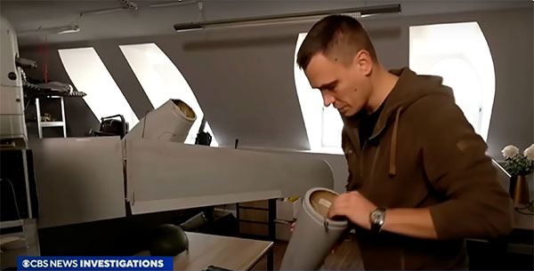
A Ukrainian intelligence assessment obtained by CNN and CBS reported an Iranian UAV downed in Ukraine contained technology from companies in the United States and other western countries. The White House has since launched an investigation as to how the technology — including semiconductors, GPS modules and engines — were obtained by Iran.
Screenshot: CBS video
The components removed from an Iranian Shahed-136 UAV totaled 52, 40 of which were manufactured by 13 different U.S. companies. The remaining components were manufactured by other western companies and companies based in Japan, Taiwan and China.The United States monitors exports and imposed restrictions and sanctions to prevent Iran from obtaining components for UAVs. Officials are now looking to enhance enforcement of the sanctions and are encouraging companies to monitor their supply chain, as well as identify third-party distributors who may be re-selling the technology to Iran.
U.S. companies are not alone in having to closely monitor their supply chains. U-blox, a Swiss semiconductor company, made a statement reinforcing its company policy, which bans the use of its technology in weapons. This was after u-blox GNSS modules were reportedly found in Russian UAVs.
On Dec. 20, u-blox banned the use of its GNSS modules in military UAVs in the war between Russia and Ukraine. The company had become aware that its GNSS modules were being used in certain Russian reconnaissance UAVs and stated that this use was against company policy.
U-blox obtained media reports that Russia had stocked up on components in anticipation of war, then integrated products from the company in UAVs it manufactured after attacking Ukraine.
After Russia began its invasion of Ukraine, the company halted all sales to Russia, Russian territories, and Russian-occupied areas, as it intends its GNSS modules and other products to be used only commercially. U-blox company policy bans the use of its products in weapons, including systems for target identification.
U-blox is investigating the infringement of its policy and plans to take legal action if it has been violated. The company also condemns the invasion of Ukraine by Russian forces.
“Seen & Heard” is a monthly feature of GPS World magazine, traveling the world to capture interesting and unusual news stories involving the GNSS/PNT industry.
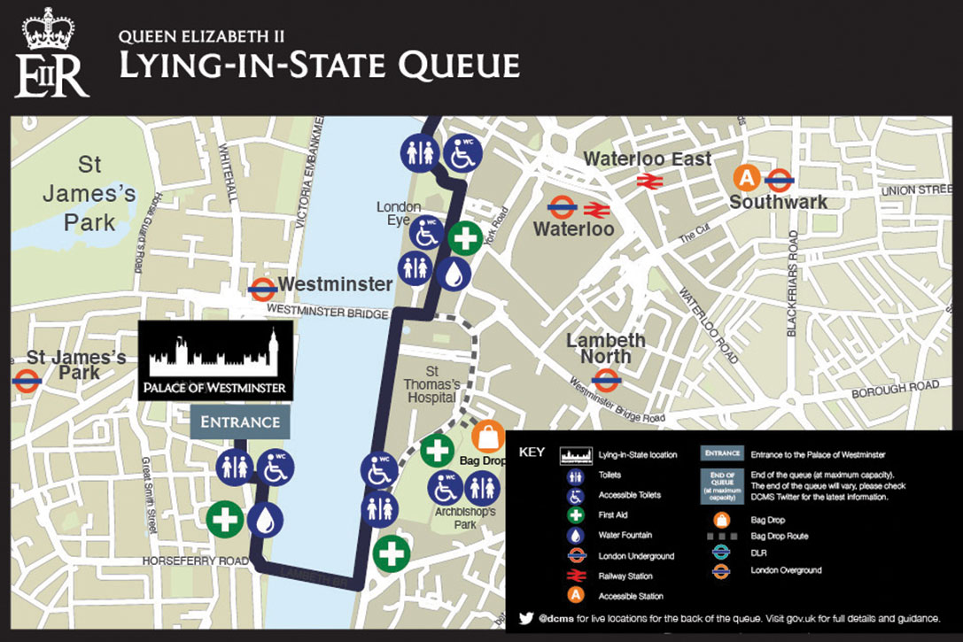
Screenshot: Lying in State Queue tracker
Queue Tracker for the Queen
After the passing of Queen Elizabeth II on Sept. 8, the British government launched a live queue tracker app to give people an idea how long they would have to wait to pay their respects at her lying in state at the Palace of Westminster. The app also used What3Words to help locate the end of the line using a three-word tag. The queue grew dramatically in the days before the funeral as tens of thousands lined up, some waiting as long as 16 hours. The app also showed locations of public toilets, drinking water and first-aid stations along the queue route.
Lake Sarez. (Photo: Astronaut Photography Collection/NASA)
A Dam Problem Solved
Lake Sarez, deep in the Pamir mountains of Tajikistan, was created only a century ago when a strong earthquake triggered a massive landslide. The area experiences considerable seismic activity, which could result in massive flooding downstream should a landslide dam break. With the help of 40 donkeys, 10 scientists and 30 staff from the National Time Service Center of the Chinese Academy of Sciences transported and installed a BeiDou-based deformation monitoring system at the dam. The team had to resolve technical problems in the rugged area, such as providing sufficient solar power and communications. With the system now operating, the dam is being monitored in real time down to the millimeter.
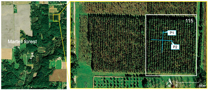
Figure 3. (Image: CC BY 4.0, Remote Sensing 14, no. 17: 4274)
Counting the Forest for the Trees
Integration of aerial and ground-based mobile mapping sensors and systems is enabling a team of Purdue digital forestry researchers to locate, count and measure more than a thousand trees in a matter of hours. “The quick, accurate inventory of the global forest ecosystem will improve our ability to prevent forest fires, detect disease, perform accurate carbon counting and make informed forest management decisions,” said Songlin Fei, the Dean’s Remote Sensing Chair. The Purdue-made systems integrate GNSS and inertial navigation devices with lidar and cameras, deployed with manned aircraft, drones and backpack-mounted systems. The technology gathers a variety of information about each tree, including height, trunk diameter and branching formation. The team maintains the precise location and time tags of all acquired features.
Photo: Skeiron
Saving Ukranian Heritage
By the end of May, at least 367 incidences of destruction had occurred to Ukraine’s museums, churches, theaters and libraries. Through the project #SaveUkranianHeritage, mapping company Skeiron is capturing sites in high detail using laser scanning and photogrammetry. For a UNESCO-protected church in Lviv, the team gathered more than 300 individual laser scans and 6,000 photos to create a 3D model. The company has two laser scanners — a Leica C10 and Leica ScanStation P20, DLSR cameras and a drone. To support the project with funding or equipment, visit skeiron.com.ua/en/saveukrainianheritage/.
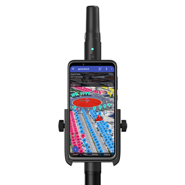
Geometer International, a Ukrainian developer of GNSS/RTK instruments and applications for satellite positioning, has introduced the Walker RTK, a dual-frequency L1, L2 RTK receiver in the compact form factor of a portable RTK device.
The Walker RTK is a lightweight, small-sized, affordable and full-featured device for collecting, storing and processing geo-referenced data on the survey site. According to the developer, a GNSS receiver in a convenient and affordable format will significantly expand the use of RTK technology. The new technology will be suited to most tasks requiring centimeter precision positioning and measurements in a 3D coordinate system.
Compact and lightweight, Walker RTK is the ideal solution for field workers working away from the office. The new device can be operated with just one hand, significantly improving the productivity of service personnel.
Possible applications for GNSS Walker RTK include surveying, utilities, solar power plant engineering, trenching and pipeline installation, drilling, forestry and municipal infrastructure control.
What’s under the bonnet of Walker RTK?
The Walker RTK is built around a 2-frequency L1/L2 184 channel board and a sensitive Helix antenna, satisfying up to 90% of basic user requirements. The tube-shaped housing geometry allows it to fit with any universal mount. The receiver weight is only 0.25g (0.470 with smartphone holder) due to the aluminum alloy housing with a protective coating. The Walker RTK has a built-in Li-Ion battery with enough power for 24 hours of continuous operation without additional recharging. The new energy-efficient architecture of the unit achieves this.
The GNSS receiver has the minimum amount of leading interfaces, resulting in high IP67 dust and waterproof rating. The device can be paired with a smartphone or tablet via Bluetooth, while connection via Bluetooth low energy is also planned for a future release.
Compatible with satellite systems
Walker RTK can track and determine geo-position using signals from all known existing satellite systems. This feature makes it possible to achieve the centimeter-level accuracy of an RTK solution within seconds.
GNSS signals processed by the Walker RTK GNSS receiver:
Thanks to NMEA messaging, the Walker RTK GNSS receiver is fully compatible with any professional or freeware geolocation software, providing high accuracy and reliable RTK-corrected positioning.
Plus: Visual AI radar aids drone searches, and a drone is released into Hurricane Ian
Just when you imagine there couldn’t be any more twists and turns to the war in Ukraine, another one turns up. Some may recall that Estonian security forces caught an Estonian/Russian man trying to send drones to Russia. The Estonian government confiscated the shipment of DJI drones.
Now Estonia has donated those drones to Ukraine for use against Russia in the ongoing war.
Remember the drones we confiscated from a person trying to donate them for the Russian aggression in Ukraine? Well, these drones still made it to Ukraine. But the right way around and on the right side of the battlefront. https://t.co/No38Bbjkom
Some might say that this is an example of, “What comes around goes around.” Nevertheless, everyone respects Russia’s nuclear options…
Making Drones Smart
It’s all well and good that we have all shapes and sizes of battery- and gas-powered drones, ones that take off and land vertically (eVTOL) or horizontally (generally, fixed-wing). But how do we make them smart enough to complete tasks on their own?
Artificial intelligence (AI) could be the answer. Take the Boeing Loyal Wingman drone. It is being developed to fly autonomously alongside high-end fighters, and perhaps to control other drones flying nearby. Those tasks require AI, which is being incorporated into the capabilities of drone systems.
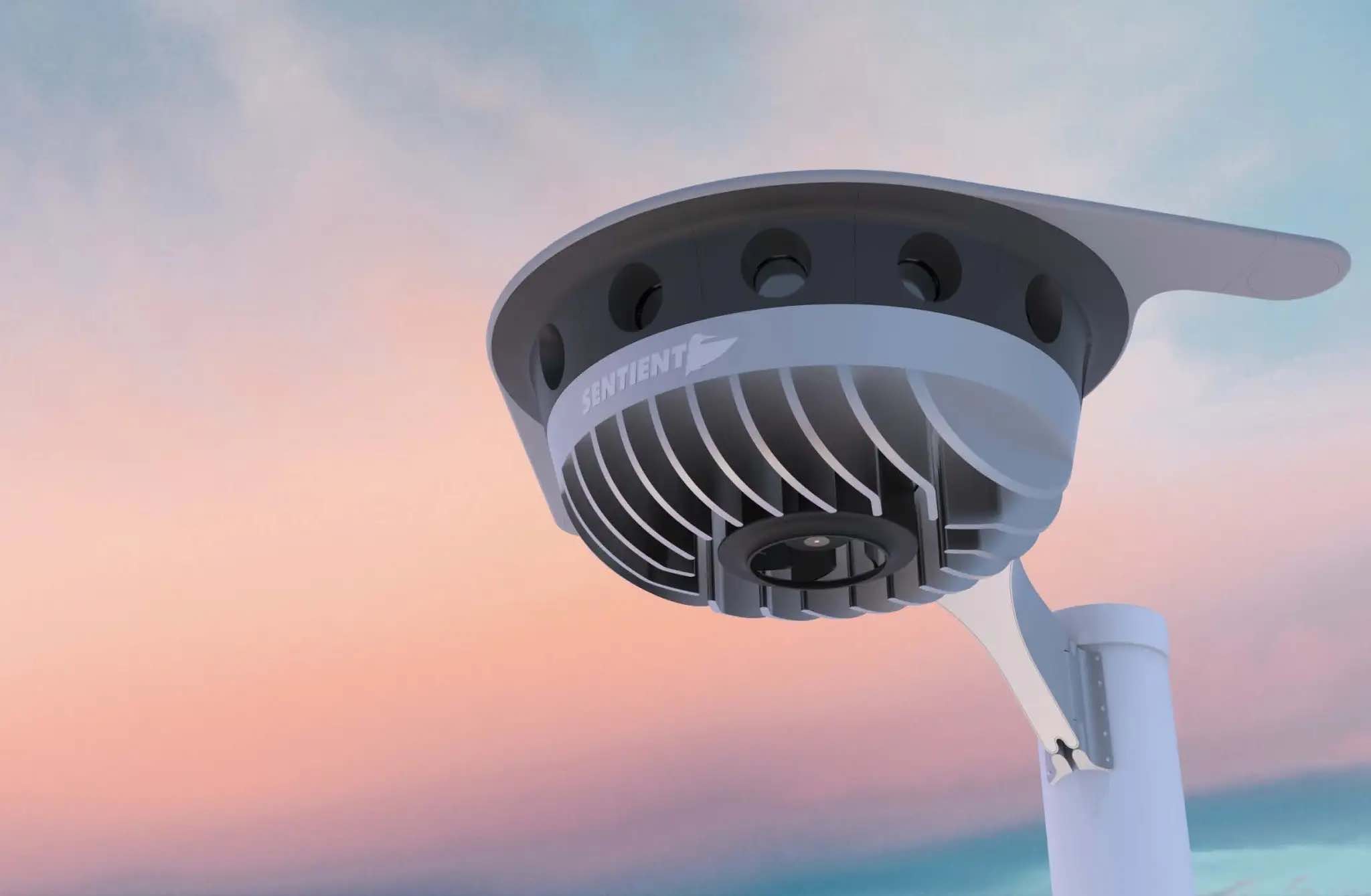
We also have immediate needs, such as search and rescue, security patrol and inspection (for commercial and military facilities, border and crowd control) and military intelligence, surveillance, target acquisition and reconnaissance (ISR/ISTAR). Along comes Sentient Vision Systems of Australia with a passive, software-based “visual radar” solution.
Sentient Vision Systems uses its digital AI processing with existing visual and infrared sensors. This combination can apparently surpass human and conventional radar capability to detect and track small moving objects.
Search and rescue at sea can be a really difficult task for people. It’s not surprising that a lot of lengthy searches end up with zilch. During a search, an aircraft flies from 20,000 feet down to 500 feet over the waves. If you have seen cabin video of air-sea searches in progress, with a searcher gazing out of the aircraft’s window for hours, straining to see something small bobbing in the sea below, it does seem like a herculean task.
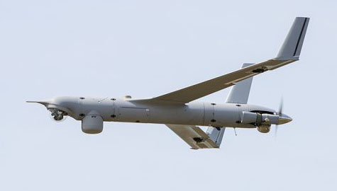
As an alternative, take a long-range (>55 nautical miles) drone, such as a Boeing/Insitu ScanEagle. Hook up the scanning search camera and high-resolution nose turret to the vidar (visual detection and ranging) processing.
Boeing/Insitu ScanEagle UAV with vidar pod. (Photo: Insitu)
As a result, you have an autonomous airborne system that can find a person in the water from a distance of about 1.7 nautical miles, and spot a ferry deck from ~30 nautical miles. Insitu claims that conventional radar systems cannot do this. In 12 hours it can search an area of about 13,400 square nautical miles.
Several such sorties might just have found an early trace of Malaysian Airlines Flight MH370 in 2014. The Boeing 777 with 239 people on board disappeared over the South China Sea 38 minutes after takeoff on a flight to Beijing. Over three years, long-range patrol aircraft covered 46,000 square miles before the search was abandoned.
During 2015 and 2016, pieces of the airplane began washing up on the shores of countries on the Western Indian Ocean. The search would probably not have been easy even for a fleet of ScanEagles, considering the logistics and the available range of the unmanned aircraft, but major incidents might find success with vidar-equipped UAVs.
Into the Eye of the Hurricane
The devastation that Hurricane Ian wrought in Southwest Florida has been terrible. A shark swimming up a street in Fort Meyers illustrates the degree of flooding left from landfall of the category 4-5 hurricane.
Ian was the strongest hurricane to make landfall in the United States in decades, with extremely high winds and strong storm surge. I sat through the storm 75 miles to the North, and it was one scary hurricane even there. I can’t sympathize enough with the residents of Lee County, who only received a warning to evacuate one day before it hit them.
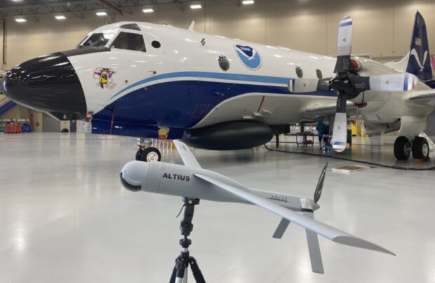
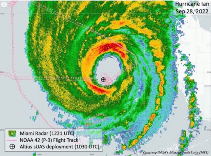
Nevertheless, the National Oceanic and Atmospheric Administration (NOAA) had its Hurricane Hunter Orion aircraft up to investigate on Sep. 28 as the storm came in from the Caribbean. Despite bad turbulence, the P-3 aircraft flew into the upper regions of the Hurricane and launched an Altus-600 27-pound drone into the eye at 4,500 feet. With a 275-mile range at up to 100 mph, the aircraft crew controlled the small drone, using it to collect data on wind speed, pressure, temperature and humidity.
The Orion P-3D Hurricane Hunter aircraft and the Altus-600 drone. (Photo: NOAA)
During the two-hour mission, the Altus drone flew into the eye wall, where winds of 187 mph were detected at altitudes between 2,300 and 200 feet. It’s not exactly clear whether the drone survived.
This radar image of Hurricane Ian shows the Altus release point. (Image: NOAA)
While information gathered may have assisted with the immediate forecasting for us Florida folks on the ground, the real scientific value comes from feeding the data into National Hurricane Center models for storm detection and analysis to keep us safer in the future.
Wrap up
To sum up, this month we saw drones destined for Russia sent to Ukrainian forces. Vidar artificial intelligence on Insitu ScanEagle drones promises huge gains for search and rescue. And, once again, a NOAA crew flew directly into the eye of a hurricane, this time releasing a drone to aid in gathering essential storm data.
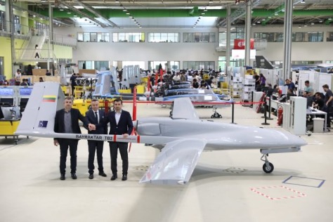
Military officials from across all branches, federal security personnel, and industry leaders gathered at the AUVSI Defense conference, held Sept. 22 in Alexandria, Virginia, to discuss critical issues surrounding the integration of uncrewed technologies.
In a publication released Oct. 11, AUVSI Senior Economic Research Analyst Aaron Bull summarized key topics discussed at the event, including:
defense priorities for the next-generation uncrewed system
how uncrewed systems will impact the ways wars are fought
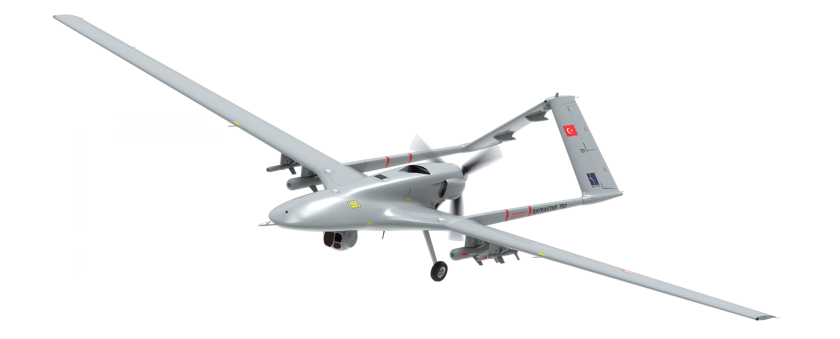
lessons learned by senior defense leaders from the Bayraktar TB2 in Ukraine.
The Bayraktar TB2 surveillance/attack drone (Photo: Baykartech)
Highlights from the Report
Flexibility in the fighting force is needed, which affects the defense requirements for autonomous vehicles heading to the battlefield.
Multiple speakers pointed to the Turkish Bayraktar TB2, a cost-effective combat-capable drone purchased and fielded by the Ukrainian armed forces that has been a game changer for Ukraine since the war began. While the drone is not top of the line, it was fielded quickly, required little training and could be fitted for a variety of purposes. As a result, “Nearly every speaker came prepared to discuss the need for developing multiple layers of flexibility around the U.S. fighting force,” Bull writes.
An uncrewed vehicle that can be refitted for multiple missions of different types offers an inherent advantage for missions, and it requires supporting logistical infrastructure.
Requirements include:
flexibility and disguise of role
ability to outfit to different technical and operating capabilities
flexibility to operate with different levels of human interaction
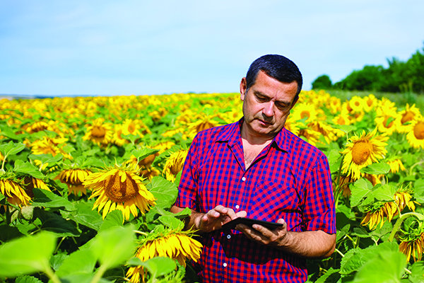
Sunflowers — soniashnyk in Ukrainian — have been grown in Ukraine since the mid-18th century. Besides being a popular snack, growing the flower for export helps fuel Ukraine’s economy. Before the war, Ukraine and Russia supplied up to 80% of the world’s sunflower oil exports.
With the Russia invasion, however, sunflower and other crops have suffered, with growth of spring crops declining as much as 40% in the eastern Donbas region hit especially hard by the war.
OneSoil Map, by OneSoil, is a new, powerful data visualization and mapping tool that combines proprietary artificial intelligence (AI) with satellite imagery to map crops worldwide. It enables agricultural businesses to visualize massive datasets and deliver insights on a global scale. Another tool, the OneSoil application, helps farmers remotely monitor crop health, detect issues and apply fertilizers and seeds, increasing yields and boosting sustainable farming practices.
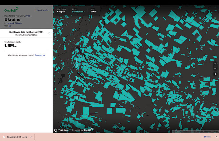
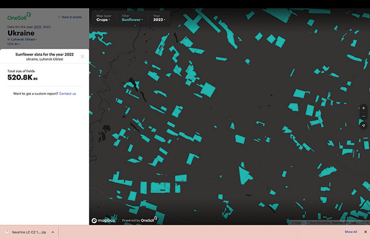
In Ukraine, satellite imagery and AI-based technologies are helping farmers face shortages and a population confronting food insecurity. OneSoil compared 2021 and 2022, and foundthe area used for the country’s spring crops— corn and sunflower— have decreased by 40% in wartorn regions, with the greatest decrease in Kharkiv (–59%), Donetsk (–58%), Luhansk (–57%) and Zaporizhia (–43%).
Corn is an export crop that accounts for 16% of the global market. OneSoil Map showed its overall acreage in the main corn production areas (Chernihiv, Poltava, Sumy) has dropped by 19% to 36%, depending on the region.
The above sample of sunflower crops in the Luhansk Oblast region — part of the wartor — shows the decrease in crop fields from 2021 (top, 1.5M acres). (Image: OneSoil)A sample of sunflower crops in the Luhansk Oblast region — part of the wartorn Donbas — shows the decrease in crop fields in 2022 (520.8K acres). (Image: OneSoil)
“Seen & Heard” is a monthly feature of GPS World magazine, traveling the world to capture interesting and unusual news stories involving the GNSS/PNT industry.
Ukrainian TV host Serhiy Prytula crowdfunded $20 million to buy Bayraktar drones for the nation’s defense against Russia. Baykar, a Turkish defense manufacturer, turned down the money and opted instead to donate three military drones to the country. The Turkish-made Bayraktar TB2 drone has been a key instrument used by the Ukrainian military to repel Russian forces, with the ongoing war the first major conflict in which the Bayraktar drones have been deployed.
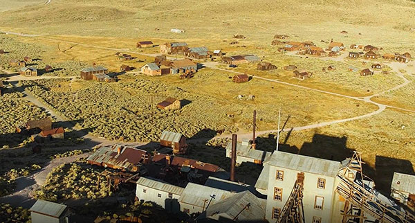
Photo: Nicola Lercari, assistant professor of World Heritage, UC Merced
Arrested Decay
Scientists from the University of California (UC) Merced have mapped the fragile remains of Bodie, a Gold Rush ghost town. With harsh weather conditions, wildfires and earthquakes, only 10% of the original town is still intact. Researchers used a GeoSLAM handheld scanner to document more than 100 structures over four days. The scans preserve Bodie’s archaeological signature and enabled a 3D reconstruction of Bodie at its height in the 1870s.
Sea-level changes are critical to the island nation of Singapore. To help map ground deformation, researchers from the Earth Observatory of Singapore will access GNSS data collected by the Singapore Satellite Positioning Reference Network (SiReNT), along with a decade of archived GNSS data. SiReNT, an initiative of the Singapore Land Authority, produces precise positioning data with up to 3-cm accuracy. With four new coastal GNSS reference stations installed, EOS is beginning to study more accurate ways to measure deformation and climate effects.
A new indoor positioning system is helping hospitals and other healthcare facilities. PenguinIN connects to a facility’s Wi-Fi infrastructure to help staff track and locate key items, a task any nurses say takes an hour of every shift. In emergency rooms, it can track how long patients have waited and how long a physician has spent with each patient. Facilities also can use it to track air quality including dust, temperature and possible water leaks. PenguinIN applies advanced machine learning to establish the location of indoor objects, people and smartphones with up to 1-meter accuracy.
ITU is the United Nations agency that deals with information and communications technology. Its remit includes coordinating spectrum use and satellite orbits.
ITU’s Radio Communications Bureau sponsors the World Radiocommunication Conference every three to four years. The issue of interference with GNSS signals was reported at the 2019 conference.
Since that time, according to this month’s circular, the group “has been informed of a significant number of cases of harmful interference to the radionavigation-satellite service…”
Despite concerns expressed by maritime and other interests, the circular focuses entirely on aviation interference. It says the reports it has received have been about “receivers onboard aircrafts and causing degradation or total loss of the service for passenger, cargo and humanitarian flights…” These have included “misleading information provided by RNSS [radionavigation satellite service] receivers to pilots.” An often cited example of this is a well-publicized 2019 incident in Sun Valley, Idaho. In that case a passenger aircraft nearly hit a mountain.
Describing interference with GNSS as a global and recurrent problem, the circular cites data collected by a major aircraft manufacturer. The company found “10,843 radio-frequency interference events … globally in 2021. The majority of these events occurred in the Middle East region, but several events were also detected in the European, North American and Asian regions.”
This year’s uptick in GNSS interference in Scandinavia, the Baltics, and around Ukraine since Russia’s February invasion of Ukraine is not mentioned. This is likely due, in part, to timing. ITU’s Radio Regulations Board met in March 2022 and directed the circular be issued.
Many within the positioning, navigation, and timing community have long asserted that interference with GNSS signals, whether deliberate or accidental, constitutes a violation of ITU rules and regulations. This month’s circular affirms this and cites several applicable provisions.
These include prohibitions on harmful interference with any authorized radio frequency transmission, requirements for users to transmit only in bands for which they have authorization, and for all to generally safeguard aviation operations.
The circular highlights provision 15.1 of ITU’s Radio Regulations as particularly applicable. It states:
“All stations are forbidden to carry out unnecessary transmissions, or the transmission of superfluous signals, or the transmission of false or misleading signals, or the transmission of signals without identification…”
As is the case with almost all international agreements, enforcement of ITU rules is the responsibility of its member states.
While most expect the advisory to have little immediate impact on reducing global interference with GNSS signals, it does help reinforce the issue as one of international concern.
According to a retired government official, “Member states that fail to comply with international rules to which they have agreed lose credibility and standing in the community of nations. Even when they have little credibility or standing to begin with, the behavior adds to their marginalization and life is just a little more difficult for them. This can, in the long run, nudge them toward being more responsible players.”
“Seen & Heard” is a monthly feature of GPS World magazine, traveling the world to capture interesting and unusual news stories involving the GNSS/PNT industry.
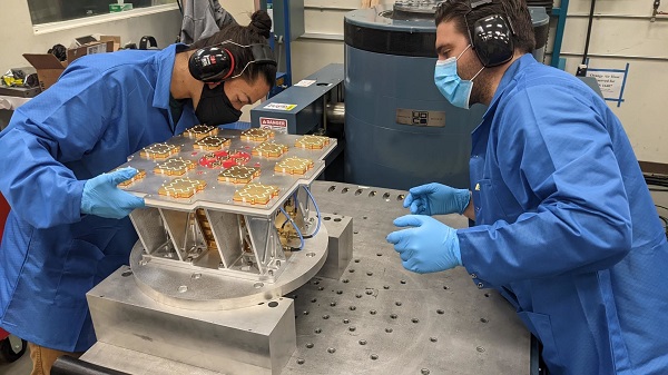
Xona’s first demonstration mission successfully completed testing at Experior Laboratories and prepares for launch on a Falcon 9 in May. (Photo: Xona)
TAKING GNSS PRIVATE
At press time, Xona Space Systems’ first in-space demonstrator satellite, named Huginn, was ready to launch on May 25 aboard Space X’s Transporter 5 mission. Xona said the launch is a significant step toward realizing its high-performance commercial navigation system, a constellation of small, powerful satellites in low Earth orbit that will meet the navigation and timing needs of intelligent systems.
U.S. cellular carrier AT&T is rolling out location-based routing to automatically transmit wireless 9-1-1 calls to the appropriate call centers, rather than relying on which cell tower handles the call. Cell towers can cover a 10-mile radius, and overlap with more than one call-center boundary. With location-based routing, a device can be located and routed within 50 meters of the device location. The “Locate Before Route” feature from Intrado enables AT&T to use device GNSS and hybrid information to route the call to the right call center.
Russian jets have been found using GPS receivers, while ground vehicles use paper maps, according to the UK Express. The GPS receivers were found taped to the dashboards of Russian SU-34s downed in Ukraine because of “the poor quality of their own systems,” UK Defense Secretary Ben Wallace said in a speech. With many reports of maintenance and aging issues for the Russian military, most likely the jets did not have quality GNSS receivers rather than the fault lying with GLONASS.
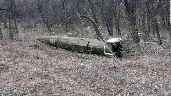
A Russian short-range ballistic missile, believed to be an unexploded Iskander missile, was found near Kramatorsk, Ukraine, in this photo released March 9 by Ukrainian authorities. (Photo: National Guard of Ukraine handout via Reuters)
UNEXPLODED BOMBS MAPPED
The HALO Trust is partnering with Esri to map unexploded ordnance in an immediate humanitarian response to the war in Ukraine. More than 10 million Ukrainians have been displaced by the war and many are forced to move across a landscape littered with unexploded rockets, bombs and landmines. In response, Esri has committed its cutting-edge geographic information system (GIS) software resources, expertise and staffing in support of HALO’s mission in Ukraine. HALO already is using GIS to map the heaviest conflict zones, and the partnership with HALO will support planning for future clearance operations.
Plus: UAVs in Ukraine, vineyard protection and a royally awesome light show
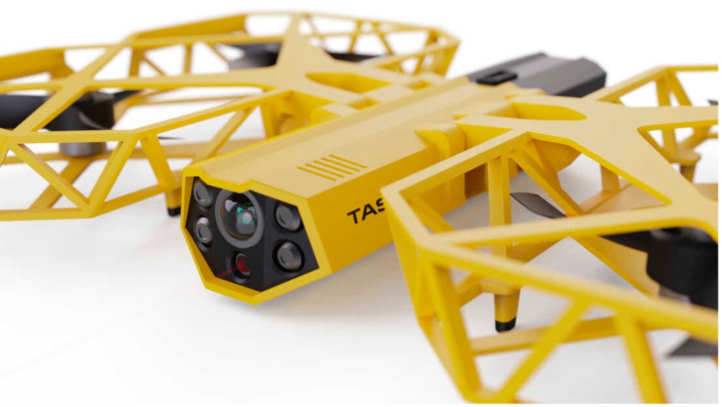
Taser-equipped drones
We hear of mass shootings in schools, and this week on a crowded street in Philadelphia a school adviser was among those killed. Everyone continues to be outraged, but as we wait for any sort of positive, preventive action by our leaders, an idea from a drone developer was shut down before it even got out of the company.
Axon taser drone concept. (Photo: Axon)
Axon Air supplies Tasers and body cameras to police forces, and last year someone came up with the idea of loading a drone with a Taser so that it could find and suppress a gunman in a school. There are a lot of problems with the idea, and Axon’s own internal artificial-intelligence board nixed the idea.
Doors were the board’s primary concern. What happens if something triggers a drone to Taser kids in the classroom or hallway? Could autonomous drones or even multiple intelligent cameras detect an actual weapon of any description, and set off an automated response?
We use metal detectors on entry to some schools to deter carrying weapons to class, but how about recognizing carried weapons in the school? To even attempt an automated drone response, you would need multiple Taser-equipped drones in all areas of a school, as well as time to test and verify that any autonomous response would work correctly.
Could anything along these lines be something we might consider in any way?
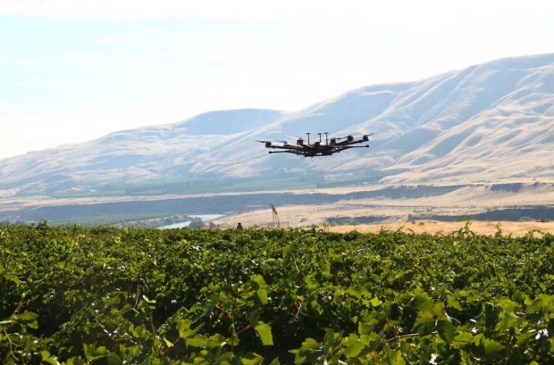
Keeping watch at vineyards
A team at Washington State University (WSU) has come up with a new twist on an old idea. Hawks have been trained effectively in the past to chase off flocks of birds on or around runways at airports or to protect crops. Now WSU has developed a system that uses intelligent cameras to detect birds, and which is then able to dispatch drones to the invaded area to chase off the birds.
The system has been tested to protect local grapevines. Bird fruit losses were actually reduced by ~50% following manual drone flights, which also reduced the number of bird invaders four-fold.
Manually flown drone patrols over vineyard. (Photo: WSU Agricultural Automation and Robotics Lab)
Nevertheless, birds can learn over time how to get round such deterrence, so WSU proposes disguising drones as predator birds and arming them with distress calls or raptor-attack behavior. WSU is looking for wine-industry support to develop this approach into a feasible, deployable solution.
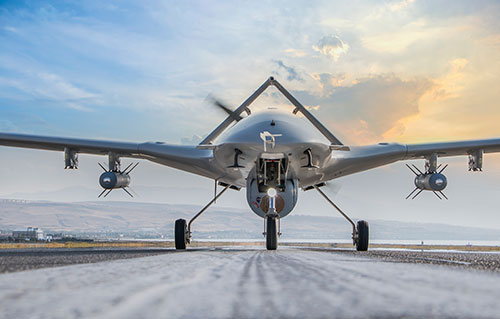
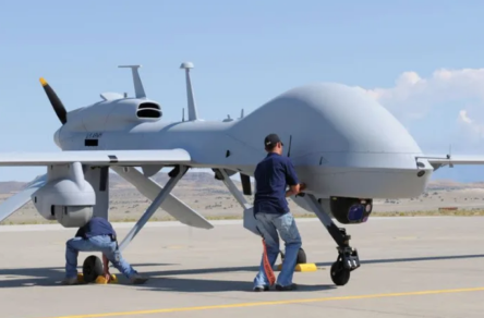
Grey Eagles might fly in Ukraine
The United States is considering providing Grey Eagle UAVs (the Army version of the Predator) to Ukraine — the first time a relatively high-tech drone with weapon-carrying capability would be supplied for the Ukrainian conflict.
The Grey Eagle can carry up to eight hellfire missiles, fly for 30 hours at relatively high altitude, and gather masses of surveillance information — a formidable, front-line weapon/reconnaissance system. Four UAVs are envisaged; missiles would not be included in the first round, but would likely come soon after.
Grey Eagle drone (Photo: General Atomics)
Th Grey Eagle UAV system usually requires months of advanced training, but the Ukrainian forces have already been operating the smaller missile-carrying Turkish Bayraktar-TB2, so training may be reduced to a few weeks for operational necessity. Meanwhile, the sale must first be approved by Congress, so nothing is yet certain.
Officials with a donated TB2 drone. (Photo: Baykar)
Before the war with Russia, Ukraine purchased up to 30 TB2 drone systems, and many have seen action in the current conflict. A crowdfunding effort by a TV station in Lithuania gathered enough cash to buy yet another TB2 to help Ukrainian forces stay in the fight.
However, Baykar, the Turkish manufacturer, declined the sale, instead offering to donate a TB-2 so that the Lithuanian funding could go toward humanitarian aid for the Ukrainian people.
Meanwhile, in Estonia the Internal Security Service (KAPO) arrested a man leaving the country who is suspected of supplying commercial drones to the Russian forces.
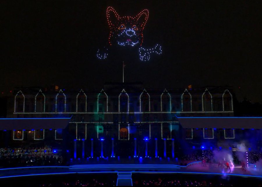
Photo: Platinum Jubilee Committee
Honoring the Queen
Finally — on a much lighter, respectful note — a drone light show was a big hit over Buckingham Palace in London on the occasion of the Platinum Jubilee concert for Queen Elizabeth II.
The queen has been on the United Kingdom’s throne for 70 years. To celebrate, the Brits hosted a major shindig. As part of a concert held outside Buckingham Palace, 400 lightshow drones from SkyMagic flew above the palace. The drones created various designs, showing the message “Thank you, ma’am”, a Corgi, a handbag, a teapot pouring into a teacup, guards in busbies, and a figurehead postage stamp — all good fun received in good spirit by a huge milling crowd.
Food for thought
To sum up, maybe it’s not such a good idea to have drones equipped with Tasers in schools, but perhaps it’s an idea we could build on to better protect our kids.
Trained, autonomous drones that take off and chase birds when they descend on vineyards — could this be a better solution than low-slung netting?
The war in Ukraine rages on. Not only the West, but also some Eastern countries pitch in with support.
Finally we saw a drone light show for the queen during the Jubilee celebration of her 70 years reign. We’re seeing a lot of smart drone potential out there.
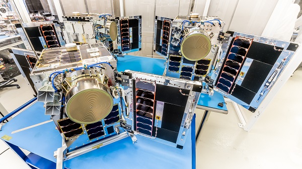
Three HawkEye 360 radio-frequency geolocation microsatellites were launched May 25. The satellites, launched aboard SpaceX Transporter-5 mission, were built by Space Flight Laboratory (SFL) of Toronto. Three SFL-built satellites for greenhouse gas monitoring were also launched.
The HawkEye 360 constellation detects and geolocates RF signals for maritime situational awareness, emergency response, national security and spectrum analysis applications.
Once Cluster 5’s on-orbit checkout is complete, the HawkEye 360 constellation will be expanded to 15 satellites, doubling capacity and revisit rates. This significantly boosts the constellation’s ability to serve global customer demand and to monitor activity across places such as Ukraine.
“Every enhanced satellite cluster we launch helps us deliver a higher density of valuable data to our government, commercial and humanitarian customers and partners – advancing our efforts to monitor global activities for a safer and more secure world,” said HawkEye 360 John Serafini. “Launch by launch, these space-based innovations are analyzing the knowns and uncovering the unknowns of the RF spectrum across the globe.”
Cluster 5 includes enhanced antenna functions introduced with Cluster 4, which allow greater flexibility in geolocating signals across a wide range of frequencies important to customers.
Cluster 4, launched April 1, has been completing checkout and moving into final formation to begin collecting data in late June. Cluster 5 is slated to achieve initial operating capability in August.
Cluster 4 on orbit. (Image: HawkEye 360)
HawkEye 360 plans to continue to grow the constellation to achieve revisit rates of about 15 minutes to support timely defense, national security and commercial applications.
SFL has now developed 15 microsatellites for HawkEye 360 of Herndon, Virginia. SFL was selected for these missions due to the importance of formation flying by multiple satellites for successful RF geolocation.
Other missions developed by SFL in the past two years include 16 communications CubeSats and three microsatellites designed for Earth observation, maritime tracking and atmospheric monitoring.
In its 24-year history, SFL has developed cubesats, nanosatellites and microsatellites that have achieved more than 191 cumulative years of operation in orbit.