Tag: Ukraine

  • A mess in Boston? Moon navigation? GNSS to the rescue

    A mess in Boston? Moon navigation? GNSS to the rescue

    This month our UAV and GNSS news ranges from a drone diving into the Boston subway to a GNSS receiver designed for Moon orbit. We also look at the types of drones heading to Ukraine to help fight the Russian invasion and rescue citizens from demolished buildings.

    Boston cleanup

    Bostonians’ morning commutes were disrupted at the end of March after 100 tons of demolition debris fell nine stories onto ground directly above subway tunnels, and the Massachusetts Bay Transport Authority (MBTA) closed the Orange and Green lines as a precaution.

    The bad news got worse. A construction worker was killed when part of a parking garage under demolition collapsed. Apparently his jackhammer-construction vehicle — in the midst of demolition work — fell nine stories when the floor near the edge of the building buckled and crumbled away.

    MBTA was concerned that damage could have occurred to the subway under the building from the huge amount of debris that fell on the ground above a tunnel. The agency closed the line passing through that section of the system. Hundreds of morning commuters were turned away from the subway at nearby station entrances and were directed to buses hastily brought on as temporary shuttles around the closed subway sections.

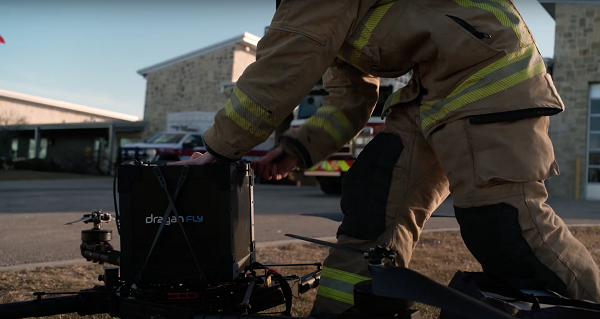
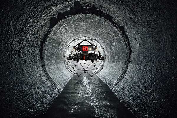
    MBTA wanted to immediately, but carefully, inspect the tunnel for damage, but was concerned for the safety of its inspection personnel. As news of the disaster circulated, the Massachusetts Department of Transportation (MassDOT) Aeronautics Division became aware of the subway issue, and proposed a rapid solution to the dilemma — to fly a drone through the tunnel. The drone would transmit high-resolution video and gather data on the status of both tracks and tunnel structure.

    Soon after, Bostonians were able to watch a 29-second video collected by the drone that was sent into the subway tunnel.

    MBTA was then able to gauge that live inspections would be safe. The tunnel was ultimately assessed as being sound and, following test trains being run, service was restored.

    It has been difficult to establish which drone was used for these initial visual tunnel inspections, but in 2021 the Aeronautics Division was operating multiple drones, including the DJI Matrice, Inspire, Phantom and Mavic, as well as a few fixed-wing and multi-rotor models manufactured by Yuneec, SenseFly and Delair.

    Flyability provides the Elios 2 drone, specifically built for indoor inspection, for such places as inside underground tunnels. Similar “caged” inspection drones include Droneball 360 by Imaze, the Skycopter Cobra drone, the Asio Caged Inspection Drone and several others.
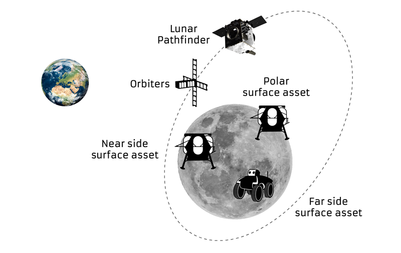
    The Elios 2 indoor inspection UAV is encased in a collision-tolerant frame to protect both the drone and the environment it’s inspecting. (Photo: © Flyability)
    The Elios 2 indoor inspection UAV is encased in a collision-tolerant frame to protect both the drone and the environment it’s inspecting. (Photo: © Flyability)

    Lunar Pathfinder

    Turning our attention to space, the European Space Agency (ESA) will conduct a mission to place a refrigerator-sized satellite in orbit around the Moon. Of course, there have been many successful efforts to put things in lunar orbit since Russia first achieved the feat with Lunar 10 in 1966. NASA’s Lunar Reconnaissance Orbiter followed in 2009, along with India’s Chandrayaan-2 orbiter and its failed lander.

    ESA has contracted Surrey Satellite Technology Ltd. (SSTL) in Guildford, UK, to develop the Lunar Pathfinder communications relay satellite — the first part of a project to provide communications and navigation for the Moon. This capability will enable assets on the lunar surface to communicate directly with the Pathfinder via S-band and UHF, which will then relay their signals onwards to Earth using X-band.

    The satellite will also carry a laser retro-reflector and a space-weather payload designed to assess the radiation environment in orbit. This should help support landers carrying astronauts, such as the NASA Artemis, by broadcasting radiation intensity to the surface.

    Artist illustration of the Pathfinder mission. (Image: SSTL)
    Artist illustration of the Pathfinder mission. (Image: SSTL)

    The Lunar Pathfinder satellite. (Image: SSTL)

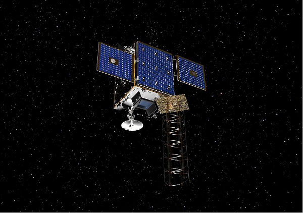
    The Lunar Pathfinder satellite. (Image: SSTL)The Pathfinder satellite will carry a few passenger payloads, but the most interesting to us might be the highly sensitive GNSS receiver, which will attempt to make position fixes from lunar orbit using GPS and Galileo satellites in Earth orbit.

    The NaviMoon receiver designed by SpacePNT in Switzerland was implemented and tested by European Engineering & Consultancy, which added a special low-noise amplifier of its own design — essential for detecting minute satnav signals at 20 times the distance they usually travel to Earth’s surface from Earth orbit. In addition, antennas on GNSS satellites are designed for transmissions towards the Earth’s surface, not out toward space, further decreasing the signal strength in the vicinity of the Moon.

    As you might expect, the view of the various constellations of GNSS satellites from orbit around the Moon is extremely limited. To give the NaviMoon receiver any sort of chance of picking up signals when they are in view, an onboard dynamic force model provides the receiver with its anticipated location along its orbit, and also derives the apparent direction from which signals should be observed. Even detecting a single satnav signal could assist the receiver in creating a position fix. SSTL will also reorient the Lunar Pathfinder satellite from time to time to enable the receiver to gain access to GNSS signals from Earth.

    Measurements from Earth using laser ranging, aimed at the laser retro-reflector on the satellite, will be used as “truth” against which the position fixes by the NaviMoon receiver will be verified.

    UAVs for Ukraine

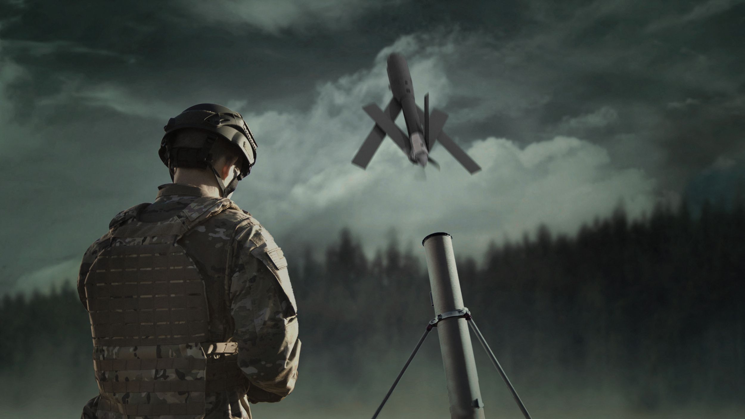
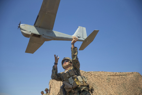
    Meanwhile, as the war in Ukraine continues to rage on, AeroVironment has been contracted by the U.S. Army to supply its RQ-20 Puma AE for use in Ukraine for almost $20 million. The package includes reconnaissance/surveillance and target acquisition kits, spares, logistics support and training for operators in Ukraine.

    The Puma has an endurance of about three hours, carries a gimbaled visual/IR camera and is equipped with dual GPS receivers.

    AeroVironment's Puma is hand-launched. (Photo: Lance Cpl. Frank Cordoba/U.S. Marine Corps)
    AeroVironment’s Puma is hand-launched. (Photo: Lance Cpl. Frank Cordoba/U.S. Marine Corps)

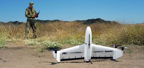
    U.S. drone manufacturers have donated hundreds of other recon drones to Ukraine. The AeroVironment Quantix Recon drone takes off and lands vertically, but flies rapidly as a fixed-wing observation platform. While its endurance is not as long as the Puma’s, it flies faster so it can return with information more quickly.

    Quantix lands vertically, but flies fixed wing. (Photo: AeroVironment)
    Quantix lands vertically, but flies fixed wing. (Photo: AeroVironment)

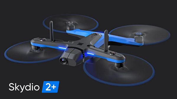
    Brinc has also donated and sold its Lemur tactical drones to Ukraine for use in disaster recovery work in devastated buildings throughout the country. The rugged quadrotor drone has two-way voice communications, video and lidar, and has proven itself in difficult building-collapse search and recovery operations in confined spaces. Skydio has apparently donated and sold quadrotor drones to Ukraine with multi-view video from six 200-degree color cameras, also for use in collapsed building search and recovery.

    The Skydio 2+ quadcopter drone. (Image: Skydio)
    The Skydio 2+ quadcopter drone. (Image: Skydio) 

    Tony Murfin
    GNSS Aerospace

  • Resilient PNT is critical, industry experts say

    Resilient PNT is critical, industry experts say

    As PNT becomes critical to more economic activities, any disruption in availability, reliability, resilience and integrity would weaken the critical infrastructure that sustains national security, business operations and public safety, according to experts speaking at the Geospatial World Forum.

    This growing dependency on PNT services — and the potentially high economic cost of vulnerabilities — underscores how vital GPS and GNSS systems are to the global economy and national security of countries worldwide, the experts said. Resilient PNT systems are necessary to combat GPS/GNSS outages.

    Robert Cardillo (Photo: GWF)
    Robert Cardillo (Photo: GWF)

    Building resilience into these systems will require multiple technologies ranging from network time-transfer services to terrestrial wireless infrastructure and low-Earth-orbit (LEO) satellites.

    The Geospatial World Forum opened in Amsterdam on May 10. The second plenary of the day focused on the value of PNT in the global economy. Geospatial World is a global think tank working towards raising awareness around the use of geospatial data and technologies among governments and policymakers, businesses, and the public at large.

    Robert Cardillo, president of The Cardillo Group and former director of the U.S. National Geospatial Intelligence Agency (NGA), headed the panel of experts.

    “Our existence on this planet has been shaped by our individual and collective awareness of place and our confidence to be able to move securely and efficiently from one place to another, all within that common framework of position, navigation and timing, or PNT,” he said.

    “The smartphone is a wonderful example of how far PNT has been integrated into our lives,” said Trimble founder Charlie Trimble. He laid down three basic phases involved in leading PNT to its place in the world economy.

    “The path from the dawn of space age to the smartphone was anything but obvious or straightforward,” Trimble said. “First, Sputnik led to the global navigation systems. Second, the Shuttle disaster led us to the realization that the satellite system was an information utility. And now, the integration of PNT into the mobile and immobile internet is changing our world.”

    From left: Charlie Trimble, Martin Sweeting, Rodrigo da Costa and Gillian Smith. (Photo: GWF)
    From left: Charlie Trimble, Martin Sweeting, Rodrigo da Costa and Gillian Smith. (Photo: GWF)

    “Our first contract was with ESA (European Space Agency) to look at the feasibility of using a navigation and timing satellite using small-satellite techniques, which in 1985 was considered a wacky idea,” recounted Martin Sweeting, executive chairman of Surrey Satellite Technology Ltd. “At ESA, we have embarked on a project called Hydro GNSS, which uses Surrey’s GNSS reflectometry to address several climate related issues, be it water detection or biomass, etc. This doesn’t stop here; we are looking at the lunar economy. PNT has indeed a very bright future, not just on Earth but also looking through this decade into the use of PNT on the lunar surface.”

    Rodrigo da Costa, executive director of the European GNSS Agency. (Photo: GSA)
    Rodrigo da Costa

    “New things are happening, particularly in the area of governmental satellite communications, space situational awareness and others, which are benefitting citizens every day,” said Rodrigo da Costa, executive director, EU Agency for the Space Programme (EUSPA). “Galileo, EGNOS (European Geostationary Navigation Overlay Service), Copernicus and GOVSATCOM programs are key areas of EU space activities. All these programs are massive investments and in the end, the result comes from their utilization in the different areas of our economy and daily life.”

    “Just in the United States alone, GPS is approaching USD 1 trillion in terms of economic impact and is doubling every 2-3 years. But it is a single point of failure. This highlights the need for resilient PNT,” said Gillian Smith, vice president of marketing, NextNav. “We believe that our needs have evolved beyond technology that was really created in the ’60s. We need increased accuracy and availability in the urban environments in particular.

    “I think many of you have experienced it if you’ve tried to use it in any major city,” Smith said. “That blue dot is going to bounce off of buildings and not be very accurate. We need indoor tracking and mapping. We need altitude data so that you know what floor you’re on when you’re thinking about accurate location. We also need to increase resilience and redundancy. That’s going to give us all increased security as well.”

    The Value of GPS

    GPS jamming and interference is a grave issue that has come under the spotlight particularly since the Russian invasion of Ukraine, according to Geospatial World.

    In 2019, a Washington, D.C., think tank documented more than 10,000 cases of GPS interference (jamming and spoofing) in the previous five years from Russia. By 2021, these had become increasingly sophisticated. In a peculiar case, the crew onboard NATO ships in Odessa saw their position being given as Crimea.

    In the past six months, even before the war on Ukraine began, there were reports of GPS jamming in and around that region. In March, the EU Aviation Safety Agency had issued warnings of GNSS spoofing and jamming for flights over Europe, in particular around countries neighboring Ukraine and Russia.

    Globally, the economic impact of GPS/GNSS disruption is difficult to state. The potential economic consequences of failing to sufficiently protect sources of PNT are enormous, with estimates ranging from millions to billions of dollars depending on the type, length, severity and geographic scope of the disruption.

    Furthermore, the impact of a GPS/GNSS outage extends beyond basic economics and could result in risk to life. Emergency services, distress beacons and telecommunications networks all rely on PNT services — any disruption could cause serious consequences.

    A 2019 report sponsored by the National Institute of Standards and Technology estimated that the loss of GPS would cost the U.S. economy USD 1 billion a day.

    A 2017 study in the United Kingdom estimated a five-day GNSS disruption would lead to an economic impact of GBP 5.2 billion (USD 7.2 billion), with road, maritime and emergency service impacts accounting for 88 percent of the cost.

  • HawkEye 360 tech reveals early GPS interference in Ukraine

    HawkEye 360 tech reveals early GPS interference in Ukraine

    Technology from HawkEye 360 Inc. has detected and geolocated extensive GPS interference over Ukraine, starting months before the Russian invasion. HawkEye 360 uses satellites to monitor radio-frequency signals that might threaten military and civil navigation applications.

    The capability was tested in 2021 in a variety of exercises and is available as part of HawkEye 360’s RFGeo signal product catalog.

    When HawkEye 360 analysts examined Ukraine over the past five months, they discovered continued and increased GPS interference across the region. The data showed extensive GPS interference in November 2021 along the boundary of the pro-Russian separatist-controlled regions in Luhansk and Donetsk.

    Open-source information confirmed unmanned aerial vehicles (UAVs) operating in the area were disrupted because of lost GPS connections.

    In February 2022, HawkEye 360 detected GPS interference along the border between Ukraine and Belarus, shortly before the Russian invasion started. This February activity occurred north of Chernobyl within the Chernobyl Exclusion Zone, demonstrating the integration of electronic warfare tactics into Russian military operation to further degrade Ukraine’s ability for self-defense.

    “GPS is a fundamental ‘global commons’ service that all modern economies depend upon. GPS signal interference has the potential to significantly disrupt air travel, logistics, finance, transportation, communication and many other basic services,” said John Serafini, CEO of HawkEye 360.

    “Whether unintentional or deliberate, interference that prevents people, vehicles, ships, and planes from determining accurate locations can be devastating to government and commercial activities alike,” Serafini said. “Since HawkEye 360 can monitor hundreds of millions of square kilometers daily, we are able to notify clients when and where GPS interference occurs, so they can respond quickly to mitigate the impacts.”

    Interference can be inadvertent by equipment operating too close to GPS frequency bands. However, deliberate interference has spiked across the globe due to the low cost, ease of deployment, and general availability of GPS jamming technology.

    Military forces use GPS jammers to obscure and protect critical troops, facilities and equipment from attack and can be a leading indicator of future military activity. Drug cartels use GPS jammers to deter surveillance from overhead drones. Use of jammers is illegal in most developed nations.

    HawkEye 360’s detection product offers a valuable capability to monitor for illicit and unintentional GPS interference that can significantly disrupt critical location services, representing the company’s global commitment to make the world a safer place, the company said.

    Image: Hawkeye 360
    Image: HawkEye 360
  • Draganfly drones head to Ukraine to meet medical needs

    Draganfly drones head to Ukraine to meet medical needs

    The first Draganfly humanitarian drone shipped to Revived Soldiers Ukraine (RSU) has arrived in Europe and will soon deliver insulin to hard-to-reach hospitals in Ukraine. Draganfly is a North American drone manufacturer.

    RSU ordered 200 Draganfly medical response drones equipped with temperature-managed payload boxes that can transport up to 35 pounds of blood, pharmaceuticals, insulin/medicines, vaccines and wound-care kits. Because insulin is a temperature-sensitive product, quick and safe transportation of the hormone is a top priority.

    About 2.3 million people in Ukraine live with diabetes. Many are Type 1 diabetics who need multiple daily injections of insulin to survive. For those living in high-conflict areas of the country, access to life-saving insulin is limited or non-existent.

    NuGen Medical Devices donated the needle-free injection devices and 5,000 needle-free disposable syringes to be filled with insulin. Not only are life-saving medical supplies like insulin dwindling in Ukraine, but there is also an urgent need for many medicines across the country as hospitals have been under direct attack since Russia invaded on Feb. 24.

    Draganfly medical relief drone. (Photo: Draganfly)
    Draganfly medical relief drone. (Photo: Draganfly)
  • US security package for Ukraine includes Phoenix Ghost drones

    US security package for Ukraine includes Phoenix Ghost drones

    On April 21, the Pentagon announced an $800 million security package for Ukraine defense, including 121 tactical unmanned aerial systems (UAS) dubbed Phoenix Ghost drones.

    According to the Pentagon, the drones were rapidly developed by the Air Force specifically to meet Ukraine’s requirements. The Ghost drones are manufactured by Aevex Aerospace and have similar capabilities to the single-use “kamikaze” Switchblade UAS from AeroVironment.

    The U.S. is also sending at least 300 more Switchblade drones, according to CNBC, though which model has not been revealed. The 300 variant is designed to strike small targets. It can fit in a rucksack, weighs a little more than 5 pounds and has a range of 10 miles. The 600 version of the weapon is designed to destroy tanks and other armored vehicles. It weighs slightly more than 120 pounds and has a range of more than 40 miles.


    AeroVironment is also donating more than 100 Quantix Recon UAS and operational training services to Ukraine’s Ministry of Defence and territorial forces. Using the actionable intelligence gathered by the Quantix Recon, operators can conduct quick mission planning and verification to help keep Ukrainian ground forces out of harm’s way. Delivery of the Quantix Recon UAS is independent of other AeroVironment tactical missile systems and UAS provided to Ukraine by the United States.

    The Phoenix Ghost drone is similar to the single-use Switchblade drone from AeroVironment. (Photo: AeroVironment)
    The Phoenix Ghost drone is similar to the single-use Switchblade drone from AeroVironment. (Photo: AeroVironment)
  • Esri, HALO Trust join to map unexploded bombs in Ukraine

    Esri, HALO Trust join to map unexploded bombs in Ukraine

    A Russian short-range ballistic missile, believed to be an unexploded Iskander missile, was found near Kramatorsk, Ukraine, in this photo released March 9 by Ukrainian authorities. (Photo: National Guard of Ukraine handout via Reuters)
    A Russian short-range ballistic missile, believed to be an unexploded Iskander missile, was found near Kramatorsk, Ukraine, in this photo released March 9 by Ukrainian authorities. (Photo: National Guard of Ukraine handout via Reuters)

    As a geopolitical and devastating humanitarian crisis unfolds in Ukraine, the HALO Trust is partnering with Esri to map unexploded ordnance as part of an immediate humanitarian response.

    More than 10 million Ukrainians have been displaced by the war and many are forced to move across a landscape littered with unexploded rockets, bombs and landmines.

    In response, Esri has committed its cutting-edge geographic information system (GIS) software resources, expertise and staffing in support of HALO’s mission in Ukraine.

    The organizations’ collaboration will allow them to map areas contaminated with explosives so HALO can remove the hazards when conditions allow. This will provide safe land to house displaced families and clear routes for humanitarian aid to reach those in desperate need.

    HALO is already using GIS to map the heaviest conflict zones, and the partnership with HALO will support planning for future clearance operations.

    As experts in their field, HALO is the world’s largest humanitarian landmine clearance and weapons disposal organization, clearing more than 13.9 million landmines and unexploded ordinance across 28 countries torn apart by conflict.

    In addition to technical expertise, HALO staff provide safety education for those in contaminated areas to avoid life-changing injuries and death, emergency medical aid, and humanitarian support for displaced persons as they face conflict, and in many cases are forced to flee their homes.

    Esri has collaborated with HALO since 2008 helping to map war-ravaged regions where specific locational awareness of landmines and other hazards is necessary to protect the lives of people in those areas.

  • Russia interfering with GPS in Ukraine, Pentagon says

    Russia interfering with GPS in Ukraine, Pentagon says

    General David Thompson at the Pentagon told NBC News that Russia is interfering with GPS signals in Ukraine.

    Russia has also reportedly jammed GPS along its borders with Finland, which has affected civilian aircraft.

    U.S. commanders say Russia has not yet attacked U.S. GPS satellites in orbit, but the U.S. Space Force continues to monitor the constellation.

  • European agency warns of GNSS outages near ukraine

    GNSS jamming and possible spoofing has intensified in areas surrounding Ukraine, according to the European Union Aviation Safety Agency (EASA).

    The agency issued a bulletin on March 17 warning of a GNSS outage leading to navigation and surveillance degradation. According to the bulletin, which was directed at national aviation authorities and airlines, reports analyzed by EASA indicate that, since Feb. 24, GNSS spoofing and jamming has intensified in four key geographical areas:

    • the Kaliningrad region, surrounding Baltic Sea and neighboring states
    • Eastern Finland
    • the Black Sea
    • the Eastern Mediterranean area near Cyprus, Turkey, Lebanon, Syria and Israel, as well as Northern Iraq.

    “The effects of GNSS jamming and/ or possible spoofing were observed by aircraft in various phases of their flights,” the bulletin stated, “in certain cases leading to rerouting or even to change the destination due to the inability to perform a safe landing procedure.”

    Potential issues include:

    •  loss of ability to use GNSS for waypoint navigation
    • loss of area navigation (RNAV) approach capability
    • triggering of terrain warnings
    • inconsistent aircraft position on the navigation display
    • loss of ADS-B, wind shear, terrain and surface functionalities
    • failure or degradation of ATM/ANS/ CNS and aircraft systems that use GNSS as a time reference
    • airspace infringements and/or route deviations due to GNSS degradation.
  • Esri stops all sales to Russia and Belarus

    Esri stops all sales to Russia and Belarus

    Logo: Esri
    Logo: Esri

    Jack Dangermond, co-founder and president of geographic information system (GIS) giant Esri, told his customers on March 10 that he is “shocked and distressed by the grim circumstances in Ukraine.” Consequently, he announced, Esri and its distributor Esri CIS have stopped all their sales to Russia and Belarus. The company is also supporting several organizations across Europe “in their humanitarian and military efforts in support of the Ukrainian government and its people.”

    “The invasion of Ukraine is a devastating chapter in our history,” Dangermond continued. “We have heard from so many members of our GIS community who, like us, stand with the Ukrainian people. Make no mistake, this is a daunting moment that will demand strength, compassion, and resolve from all of us.”

  • European agency warns of GNSS outages near Ukraine

    European agency warns of GNSS outages near Ukraine

    Photo: franckreporter/E+/Getty Images
    Photo: franckreporter/E+/Getty Images

    In the current context of the Russian invasion of Ukraine, the issue of GNSS jamming and/or possible spoofing has intensified in geographical areas surrounding the conflict zone and other areas, according to the European Union Aviation Safety Agency (EASA). The agency issued a safety information bulletin on March 17 warning of a GNSS outage leading to navigation / surveillance degradation. According to the bulletin, which was directed at national aviation authorities and airlines, reports analyzed by EASA indicate that since February 24 GNSS spoofing and/or jamming has intensified in four key geographical areas:

    • the Kaliningrad region, surrounding Baltic Sea and neighboring states
    • Eastern Finland
    • the Black Sea and
    • the Eastern Mediterranean area near Cyprus, Turkey, Lebanon, Syria and Israel, as well as Northern Iraq.

    “The effects of GNSS jamming and/or possible spoofing,” the bulletin stated, “were observed by aircraft in various phases of their flights, in certain cases leading to re-routing or even to change the destination due to the inability to perform a safe landing procedure.” It pointed out that in the present conditions it is not possible to predict these outages and their effects. Potential issues include:

    • loss of ability to use GNSS for waypoint navigation
    • loss of area navigation (RNAV) approach capability
    • inability to conduct or maintain various operations
    • triggering of terrain warnings, possibly with pull-up command and
    • inconsistent aircraft position on the navigation display
    • loss of automatic dependent surveillance-broadcast (ADS-B), wind shear, terrain and surface functionalities
    • failure or degradation of ATM/ANS/CNS and aircraft systems that use GNSS as a time reference and
    • airspace infringements and/or route deviations due to GNSS degradation.

    The bulletin also offers several recommendations to airlines for mitigating these issues.

  • FCC, FAA and 5G

    FCC, FAA and 5G

    Last month we attempted to provide an overview of the issue concerning Federal Communication Commission’s (FCC) licensing of C-Band radio spectrum, the subsequent fielding of wireless service for 5G phones and the Federal Aviation Administration’s (FAA) announcements that potential interference could be possible between 5G signals and C-Band radio altimeters on commercial aircraft.

    Not a big deal most people might say, as faster and improved phone and data messaging on their smartphones begins to kick in, while wireless companies continue roll-out of the new 5G service. But wait – don’t some of these people fly out on vacation and then back and land at local airports, and many of us fly around the US to visit friends and family, or each week shuttle around the country doing fly-in/fly-out business?

    Well FAA and the wireless companies have largely collaborated during 5G service roll-out, and the FAA has been rapidly clearing a good number of rad-alt (radio altimeter) equipped aircraft to continue regular operations into most airports. And it seems that wireless companies have limited 5G fielding around some US airports by reducing transmitted power and/or limiting the density of 5G towers.

    But where are we now? Seems some aircraft equipped with some types of rad-alt can fly into some airports – the FAA published a list for aircraft operators and pilots identifying who can do what and where. They also published several ADs (Airworthiness Directives) which limit several aircraft types from flying into certain airports, ‘prohibiting certain operations, which require radioaltimeter data to land in low visibility conditions, when in the presence of 5G C-Band interference’. For any aircraft passengers flying into LaGuardia on a foggy day or Boston when ice-fog hangs in the air – low visibility landing capability on modern aircraft is a blessing and a wonder which allows us to travel, even in bad conditions.

    Seems that, typically – ‘many systems on (XY Type) aircraft rely on the radio altimeter, including autothrottle, ground proximity warning, thrust reversers and Traffic Collision Avoidance System,’ says one recent FAA AD.

    That’s a whole bunch of critical systems which help an aircraft land. Many experts over many years have spent whole careers supporting the process of developing safety systems for auto-land and those which assist in the manual landing of aircraft. And the FAA and other agencies around the world have made every manufacturer prove and prove again that these systems work and work extremely, reliably, well.

    Not that I’m against 5G – I have a 5G phone and I’m eagerly waiting for 5G applications to use on my phone. – the service seems to be very fast when in an area where 5G has been fielded. There are some wireless companies who have decided that 5G can by-pass cable in the distribution of TV channels – this is good stuff! Let’s have more of it!

    But why on earth do we need to even partially compromise any aircraft systems which safely land aircraft?

    Japan and France have been cited as counties in which 5G has not had any impact on the very same aircraft and their operations with which the FAA has found problems. Well, except those countries seem to have taken steps in the fielding of 5G which have protected their aircraft operations. The FAA quotes several mitigations used in those countries:

    • Lower power levels

    • Antennas adjusted to reduce potential interference to flights

    • Different placement of antennas relative to airfields

    • Frequencies with a different proximity to frequencies used by aviation equipment

    Let’s hope that FAA’s intense efforts to test and clear rad-alts under the simulated intensity of C-Band interference around airports will continue unabated and that soon we aviation nuts will begin to breath more easily.

    And let’s hope that the wireless companies cooperation, acceptance and mitigation steps – for which the whole aviation community is extremely grateful – that these very positive steps will directly lead to the whole issue fading away over time as old news.

    And then a few words about ‘the war‘ which Russia just began against its neighbor and previous member of the USSR – Ukraine has been independent from Russia since the USSR ‘dissolved’ (Wikipedia) in 1991.

    Ukrainians are pretty resilient and the news today is that a woman in Kyiv brought down a Russian drone by throwing a jar of pickles at it from her (high-rise?) balcony. This story of course isn’t verified, but it’s a small lightness in a very grim situation.

    General Atomics armed MQ-9 Reaper (Militaryanalizer.com)
    General Atomics armed MQ-9 Reaper (Militaryanalizer.com)

    And its reported that Poland just placed an urgent operational requirement for armed MQ-9 Reapers in order to better protect its Eastern border with Ukraine. The border is around 530 miles long and is the main crossing point for the thousands of refugees fleeing the Russian onslaught. Poland has apparently already taken in almost a million people seeking safety.

    Drones are now part of modern warfare and both East and West have pretty sophisticated, capable, weapon-carrying unmanned aircraft. But they also usually carry highly accurate satellite navigation and laser-guided weapons which may minimize unintended casualties – unless casualties are exactly what the Russians are after.

    Really sad state of affairs which we all may still follow in detail through news reports, even though Russia has completely shut down social media and virtually outlawed on-the-ground news reporting.

  • Finnish airline finds GPS interference near Russian border

    Finnish airline finds GPS interference near Russian border

    Photo: william87/ iStock editorial/Getty Images Plus/Getty Images
    Photo: william87/ iStock editorial/Getty Images Plus/Getty Images

    Finnair planes flying close to the Russian border near and south of Finland are reporting unusual activity with their GPS receivers in the last few days.

    No cause for the abnormalities has been determined, but the vicinity to the Russian border during the Ukraine war seems to indicate intentional interference. In particular, interference occurs near the Russian province of Kaliningrad situated between Lithuania and Poland, both NATO members.


    An aircraft operated by Lithuanian carrier Transaviabaltika has been unable to fly from Tallinn to Savonlinna for three days.


    Traficom, the Finnish Transport and Communications Agency, has received numerous occurrence reports regarding GPS signal interference observed by aircraft. The interference began during the weekend and is still continuing.

    On Tuesday, several aircraft reported GPS signal interference in the region around Mikkeli, Jyväskylä and Kuopio. An aircraft operated by Lithuanian carrier Transaviabaltika has been unable to fly from Tallinn to Savonlinna for three days.

    Kaliningrad is the capital of the Russian province of the same name, sandwiched between Poland and Lithuania along the Baltic Coast. (Map: Google)
    Kaliningrad is the capital of the Russian province of the same name, sandwiched between Poland and Lithuania along the Baltic Coast. (Map: Google)

    After receiving reports about GPS interference, Traficom on Monday requested Fintraffic Air Navigation Services Ltd (Fintraffic ANS) to issue a Notice to Airmen for pilots flying in the area.

    “Flying is still safe. Airlines have procedures they follow if the GPS signal is lost,” said Director Jari Pöntinen. “Aircraft can use other systems to navigate and land safely. Air traffic control supports aircraft pilots with the help of other landing systems.” For final approach, traditional approach systems do not require a GPS signal.

    Airlines make their own decisions on whether they can operate in an area where there is known to be interference to the GPS signal.

    Traficom does not know what is causing the interference, but stated it will continue to monitor the situation and gather more information on the matter.