Spirent is one of only 226 organizations in the United Kingdom to be recognized with the Queen’s Award, which acknowledges the company’s excellence in international trade.
Spirent is headquartered in the UK, with its positioning business in Paignton, Devon, developing and manufacturing positioning, navigation and timing (PNT) test solutions. It also has a research and development facility in Daventry, Northamptonshire.
“As reliance on PNT technology continues to grow, our positioning technology business is the trusted partner of the world’s foremost PNT developers, delivering maximum performance without compromise through our dedicated test and validation solutions,” said Martin Foulger, general manager, Spirent Positioning. “We are honored to receive the prestigious Queen’s Award accolade, which is testament to the hard work of our employees in enabling us to achieve such tremendous success worldwide.”
Powered by its international trade, its exports outside of the UK represent a significant proportion of its business, serving a global customer base across five continents and more than 40 countries. Its technology has represented the global gold standard for commercial and government research and development facilities since the inception of GPS.
Its core business is the simulation of GNSS signals in laboratories for the development of applications used in advanced aircraft, chipsets, satellites, smartphones, cars, autonomous systems, marine vessels and defense systems, as well as the navigation systems themselves.
“Market leaders who are developing PNT applications have placed their trust in our test solutions for decades due to our unrivaled performance, realism and reliability,” said Foulger. “Furthermore, Spirent expertise is directly enabling and driving innovation in connected and autonomous vehicles and machine learning, as well as helping to make the world more sustainable through working closely with fields such as smart cities and precision agriculture.”
Now in its 56th year, the Queen’s Award are the most prestigious awards for businesses in the UK and a globally recognized royal seal of approval for companies. As a winner of the award, Spirent is permitted to display the esteemed Queen’s Awards Emblem for the next five years.
An expert has warned the government of the United Kingdom that the lack of an alternative to Galileo threatens to put critical infrastructure at risk, according to a report in Daily Express.
Andy Proctor, formerly with the satellite and positioning, navigation and timing (PNT) cabinet office, submitted evidence of his concerns to the UK’s ministers.
“Our critical infrastructure is at risk from the loss of PNT, space-based or otherwise,” he wrote. “We are currently critically dependent upon GPS; the loss of which will have a major impact in capability and economically.”
Proctor is director of Rethink PNT, a consultancy firm.
He pointed out that the government disinvested in the eLoran terrestrial system that could have provided a backup, although this is slowly reversing.
“For 20 or so years there have been calls for action, yet the current status of inaction regarding the PNT strategy puts our systems at increasing risk, especially given the clear and present electronic-warfare systems being used in Europe today,” Proctor wrote.
Britain was removed from the Galileo project following Brexit, and has since been looking for an alternative PNT system.
A new software app helps local governments in the UK plan alternative routes, infrastructure and access that facilitate walking and cycling in cities, reducing traffic. XMAP, a cloud-based web geographic information system (GIS) for local governments from Geoxphere, now offers Isochrone. It provides a detailed and visual insight into existing transport infrastructure, assessing accessibility and the local environment to calculate and compare travel times by foot, cycle and car. The tool enables planners to understand how the existing infrastructure is enabling or restricting green journeys. It also helps them model and visualize how improvements to the transport network can be made and engage with communities to promote specific schemes and opportunities for active travel.
The XMAP Isochrone tool allows a user to create polygons on a map showing how far it is possible to drive, walk or cycle in a set amount of time. Using algorithms that take into consideration the actual road, foot path or cycle network, as well as historic speed data and average walking and cycling rates, it provides a more accurate methodology of calculating travel times compared to traditional concentric circles based on straight line distances.
XMAP is accessible from any web-enabled device, without plug-ins, bolt-ons or additional installations. It includes a suite of inbuilt workflows to support delivery of local government services such as planning, housing, waste and recycling, and street services. XMAP comes complete with more than 250 geospatial data layers, from a variety of government agencies, as well as a fully maintained Ordnance Survey map stack.
Provided as a Software as a Service (SaaS), XMAP allows users to create and share business-critical map data without the risks involved in using open-source silos of GIS or the high cost of traditional GIS solutions. XMAP gives access to Ordnance Survey mapping, aerial photography, together with third party and in-house datasets, for more than 1,700 government organizations as well as a range of commercial clients.
The United Kingdom has issued a market exploration document for alternative navigation for weapon systems to support GNSS.
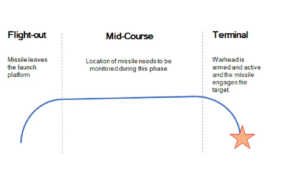
Specifically, UK Defence Equipment and Support (DE&S) and the Defence and Security Accelerator (DASA) want to understand the range of technologies used for commercial positioning and navigation systems. Its main area of interest is to know the location of the weapon during the mid-course phase of deployment, as shown in the figure below, with an accuracy of ±5 meters. Technology guidance to the final target is not part of the scope.
Project focus is location of the weapon during the mid-course phase of deployment with an accuracy of ±5 meters. (Image: UK Defence)
With GNSS vulnerable to jamming and spoofing, the exploration is interested in supporting navigation and positioning technologies, such as:
Terrain contour matching (TERCOM): uses a radar altimeter and a digital terrain elevation database.
Digital scene matching (DSMAC): matches an onboard image to an imagery database.
Inertial navigation systems (INS) or inertial measurement units (IMU): rely on accurate measurements of velocity and time to calculate position.
The market exploration is part of a larger Technology Demonstration Program. The defense agencies recently ran an Innovation Focus Area looking at quantum navigation systems, and selected several proposals for funding.
Quantum technology is not specifically out of scope for this exploration, but the agencies are specifically looking for technologies that could be developed to a testing and trialling prototype within the next three years.
The United Kingdom’s Defence and Security Accelerator (DASA) has launched a new Market Exploration called Alternative Navigation for Weapon Systems, which aims to explore alternatives to GNSS for military navigation.
The Market Exploration is being run on behalf of Defence Equipment and Support (DE&S) and seeks to understand the range of technologies used for commercial positioning and navigation systems.
GNSS such as GPS and Galileo are widely used for commercial and military positioning and navigation, but these systems are vulnerable to jamming and spoofing. DASA wants to explore alternative navigation technologies that could be developed and trialed within the next three years.
The potential system should:
be developed to an operational level in either a civilian or on military application
have the potential to be further developed to meet military specifications.
have sufficient accuracy to monitor position during deployment to within 5 meters.
The agency is particularly interested in innovations from non-traditional defence suppliers and has a dedicated team of DASA Innovation Partners who can discuss proposals with submitters.
Satellite communications company Inmarsat is working on a United Kingdom Space Agency-funded test project with the European Space Agency to deliver the first UK-generated satellite navigation signal. The project provides a potential platform for the UK to enhance its post-Brexit positioning, navigation and timing (PNT) capabilities.
Repurposing a transponder from the Inmarsat-3 F5 satellite, the test project — known as UK Space-Based Augmentation System (UK SBAS) — will provide an overlay signal to augment the U.S. GPS, refining its accuracy from a few meters to a few centimeters.
UK PNT without EGNOS
The UK no longer has access to the European Geostationary Navigation Overlay Service (EGNOS) Safety of Life services since leaving the European Union (EU) and is not involved in the EU’s Galileo programme for similar reasons. Therefore, this new national capability supported by current and future Inmarsat satellites could offer a new option for high-integrity, precision navigation across the country, in its airspace and within surrounding waters.
UK SBAS will provide a basis to assess its future development into an operational capability to support safety-critical applications such as aircraft approaching and landing at airports or navigating ships through narrow channels, especially at night and in poor weather conditions.
Goonhilly will provide the uplink for the system from Cornwall. Software from GMV NSL, based in Nottingham, will generate the ground-based navigation signal. This is a similar system to that already in use in Australia and New Zealand, supported by Inmarsat.
The project could be crucial for UK users who need accurate, high-integrity navigation capabilities to enable their operations. It will initially cover aviation and maritime operations, but has the potential to extend into rail and other land-vehicle applications. For example, UK SBAS will comply with International Civil Aviation Organization (ICAO) standards.
“It is very welcome news to hear that UK-based companies have teamed up to deliver this ground-breaking project, with help from government funding,” said Transport Minister Trudy Harrison. “From flying planes to steering ships, reliable and precise navigation support is a crucial part of travel. This development is a significant step forward for our world-leading space sector, as we accelerate towards a net-zero transport future.”
Best satellite candidate
Artist’s impression of an Inmarsat-3 satellite. (Image: Inmarsat)
The Inmarsat-3 F5 satellite is in geosynchronous orbit at 54° west, ensuring that its signal covers the UK as part of its Atlantic Ocean region service overlay. This makes it an ideal candidate to participate in the test. The satellite was manufactured by Inmarsat’s Athena partner Lockheed Martin and launched in 1998.
“This project demonstrates British innovation at its best,” said Nick Shave, vice president of Strategic Programmes for Inmarsat Global Government. “Working with Goonhilly Earth Station and GMVNSL, supported by UK funding via the ESA Navigation Innovation and Support Programme (NAVISP), enables us to extend the long life of Inmarsat’s I-3 F5 satellite with additional new services designed two decades after launch.
“We look forward to exploring the potential for this project and the benefits it could deliver to the UK with more precise, high-integrity, resilient navigation services, whilst also exploring future capabilities on new satellites through Inmarsat’s fully funded technology roadmap,” Shave said. “This work also has the potential to be exported to other nations around the world, benefitting the UK economically as well as technologically.”
Admiral Lord Alan West of Spithead has served the United Kingdom as First Sea Lord and led the government’s efforts for counter terrorism and cybersecurity. He has been a member of the House of Lords since 2007 and has stayed engaged with defence and maritime issues. RNT Foundation President Dana A. Goward spoke with him in early September about the UK’s way forward for GPS-like services.
DG: The UK government has been talking for years about the nation’s vulnerability to disruption of space-based signals such as those from GPS and Galileo. What is being done about it?
LW: Unfortunately, the government is not being as transparent as we might like on this. I do know from comments made in the House of Lords that there is a group developing a strategy. Also, that the Cabinet Office — our equivalent of the National Security Council in the United States — is deciding who is to be in charge and how things will be run.
I have heard the strategy group will propose a mix of technologies such as has been discussed in the United States. The idea of having several different systems, I am sure, is so that something interfering with one won’t disrupt them all.
This is all supposed to published in November. But I am concerned that government distractions with COVID, Afghanistan and other issues will delay that.
DG: What about the OneWeb project? That doesn’t seem to be waiting for a November announcement. And there is talk it may provide GPS-like timing and navigation services.
LW: OneWeb is moving forward, but at present it is only about 5G and making it available more quickly and broadly. There may be a OneWeb Phase 2 that includes modified or additional satellites to provide positioning, navigation and timing (PNT), but that is to be decided.
Admiral Sir Alan West, then First Sea Lord, is pictured with the official chart of anchorages for the International Fleet Review. (Photo: DP Kilfeather’s book Trafalgar 200 Through the Lens, Queen Elizabeth II 80th Birthday Edition, CC BY-SA 2.5)
DG: How about the UK rejoining Galileo?
LW: Actually, that makes a lot of sense from a practical point of view for both the UK and Europe. Unfortunately, there were a lot of hurt feelings on the continent with Brexit, some EU leaders seemed to be in punishment mode, and expulsion from Galileo was part of the fallout. I think that in due course as tempers cool, we will fully re-engage with the European Space Agency.
DG: So, no UK project for a GPS equivalent?
LW: The government allocated £90 million to that, which enabled a thorough look at the idea but was woefully inadequate to even start a project. Doing a British version of GPS or Galileo would be hugely expensive and doesn’t make sense. There are better, cheaper ways of getting what we need.
DG: And what does the UK need? What is the goal?
LW: We need several things.
First, we need a global capability that is ours, or that we are closely partnered in, to support the UK’s worldwide military and economic interests.
We also need to have something in place so that, even if space is denied to us — and that is getting to be more and more of a threat each day — we can keep our industries, critical infrastructure and economy going at home.
And third, we need a resilient PNT capability as a foundation for current applications, and to build on for such things as autonomy, intelligent transportation, and the like.
DG: So how do you get there?
LW: For the global bit, the OneWeb, and perhaps an even closer partnership with the United States on GPS.
At home, we definitely need a sovereign capability for when space is denied by solar weather or our adversaries. Also to be a check on space signals because our adversaries and criminals are spoofing them more and more.
I have always thought eLoran was a good choice. The UK pioneered its development and had the world’s first operational system in 2015. It is really hard to interfere with the signal, and there are other features that could be added to it that would make it even more robust.
There was a very interesting report called MarRINav put out last year about what UK maritime needs to ensure it can navigate regardless of whether the satellites are working or not. They came up with a reasonably inexpensive combination of systems anchored by eLoran.
By the way, it is interesting that the MarRINav study was funded by the European Space Agency. They seem to understand that satellites are not the be all and end all for PNT services.
DG: That all seems pretty straightforward and the right thing to do. What’s standing in the way?
LW: Well, so few people understand the problem. The population as a whole is almost completely unaware. At some level government understands all 13 of our critical infrastructure sectors could be impacted, but the people senior enough to drive action have dozens of other issues to deal with that probably seem more urgent.
DG: I wonder what it will take to make it seem urgent enough.
LW: Let’s hope the wakeup call is something short of a national disaster.
For a major project, surveying with traditional GPS equipment would normally take many days, Learn how Trimble and Propeller helped speed progress.
Wills Bros, a family-run contractor based in the UK and Ireland, has begun work on the £29 million (USD $40 million) Maybole Bypass project in Scotland. The 6-km (~ 3.75-mi) project involves 900,000 cubic meters of earth removal and a further 15,000 cubes of rock that needs to be excavated and removed. In addition, Wills Bros is responsible for the construction of 10 culverts to deal with water flow in the area.
For a project this size, surveying the entire site with traditional, ground-based GPS equipment would normally take six days, estimates Jonathan Wills, who was instrumental in the company’s recent investment in Trimble and Propeller equipment. But considering the increased accuracy tolerance required for some of the structural elements involving the culverts, getting useful survey data from the ground would actually take weeks for this project.
As an alternative, Wills Bros is using Propeller PPK, a drone surveying workflow that combines DJI’s Phantom 4 RTK drone; AeroPoints’ “smart” ground-control points; offloaded data processing; and the Propeller Platform software that allows measuring of the site using 3D models generated from drone images. Wills Bros also is using Trimble Stratus for cloud-based drone survey processing, visualization and analytics with Propeller Platform.
Wills Bros was able to collect an initial earthwork takeoff of the Maybole project area in a fraction of the time.
“Savings on labor costs alone have been considerable given the fact that on so many occasions we can now obtain detailed project data within a second rather than sending a man on site to survey for information,” Wills said. “The drone comes in a backpack and is up in the air doing its thing within minutes. From the outset, the time savings are immense.”
Once the drone and ground-control data are uploaded, Propeller transforms them into a 3D terrain model that can be measured in the cloud-based Propeller Platform.
A new map detailing the location, height and canopy for trees more than 3 meters in height is helping Sevenoaks District Council manage its iconic ancient trees and natural woodland.
Derived from Bluesky’s National Tree Map, which provides geospatial intelligence for more than 300 million trees across the United Kingdom, the data has already been used to create a district-wide map of tree cover, to create 3D visualizations to inform development decisions, and to support planning enforcement investigations.
Sevenoaks District Council originally purchased National Tree Map data from Bluesky in November 2019, and the data is widely used across the council with specific applications in planning.
Updated this year, the original and new tree-map layers are stored in the council’s GIS alongside multiple years of aerial photography, Ordnance Survey maps, data such as Ancient Woodland and Biodiversity Opportunities, and council data including Tree Preservation Orders and Planning Applications. The tree data is accessible to all staff via the council’s intranet mapping system GISMO (GIS Online).
The name Sevenoaks (the name given to the town and more recently to the district) dates to circa 800 A.D. and is thought to be derived from “Seouenaca,” the name given to a small chapel near seven oak trees. Records of these trees through the ages are sparse; it is not until the 19th century when a group of seven trees appears on an Ordnance Survey map.
The eponymous oak trees have been replaced many times over the years, including the planting of seven oaks to commemorate the coronation of Edward VII in 1902 and tree planting by personnel from the Canadian Air Force in 1947 in gratitude for being billeted in the town.
Bluesky’s National Tree Map is created using innovative algorithms and image processing techniques in combination with the most up-to-date and detailed aerial photography, terrain and surface height data, and color infrared imagery.
In addition to the three vector map layers — Crown Polygons, Idealised Crowns and Height Points — the Bluesky National Tree Map also includes an attribute table with unique identification for each crown feature, height attributes and area calculations.
1Spatial is making complex workflows easier to manage with the latest releases of its core products 1Integrate and 1Data Gateway. 1Spatial is a global geospatial software and solutions company.
1Data Gateway 2.4 now has an extended REST API enabling automated submission of data from other applications, while maintaining access control and security of the data supply chain. Submission metadata can be passed back into 1Integrate sessions for downstream processes and analysis. 1Integrate 2.10 can also be configured to “fast-track” certain sessions onto higher priority engines, ensuring important submissions are not left queuing behind other routine jobs.
“Even though 1Data Gateway is primarily a user portal to our rules engine, the addition of the Submission API will allow our customers to integrate the power of 1Data Gateway into automated workflows and access the rich statistical data collected from the submissions,” said Ricardo Cifres, 1Data Gateway product manager.
UK Contract Awarded
Following a competitive tender and in collaboration with Version 1, a global IT services and solutions company, has signed a multiyear contract with the United Kingdom Department of Environment, Food and Rural Affairs (DEFRA) to provide a managed service for the Rural Payments Agency’s (RPA) Rural Payments Service and Land Management System (LMS).
The contract will provide a recurring managed service enabling DEFRA and the Rural Payments Agency to deliver its current Basic Payment and Countryside Stewardship Schemes. In addition, the new contract enables 1Spatial and Version 1 to support RPA and DEFRA through Agricultural Transition.
1Spatial has worked with RPA over the past five years to support and develop its Land Management System, an ecosystem of IT components, processes and data, including 1Integrate software. The LMS is RPA’s key control system used as a remote-sensing monitoring tool and to master the land registration data used for subsidy-scheme validation and agricultural policy implementation.
NATO forces are deployed in some of the world’s most aggressive electronic-warfare (EW) environments. Intentional interference comes both from “personal protection” devices and large, high-powered EW assets.
To navigate despite EW, armed forces need reliable and resilient GNSS/GPS positioning with anti-jam technology. The Light Dragoons — a light cavalry regiment of the British Army — are in a perfect position to test anti-jam technology for assured positioning, navigation and timing (A-PNT).
The Light Dragoons were deployed as the United Kingdom’s Light Cavalry contribution to “Battlegroup Poland,” part of NATO’s enhanced Forward Presence. On the front line, the Light Cavalry engage in reconnaissance, mark targets for indirect fires, and prepare routes for the rest of the force. In this role, being prepared for EW is essential.
To test A-PNT technologies, the Light Cavalry took part in Project Thundercat, a light cavalry capability investigation run by the Armoured Trials and Development Unit (ATDU). A Hexagon | NovAtel GPS anti-jam technology (GAJT) antenna, the GAJT-410ML, was fitted to a Jackal high-mobility transporter and integrated with its onboard positioning system.
GAJT successfully defeats jamming on GPS L1 and L2 and Galileo E1 frequencies. When interference is detected, GAJT recognizes the unwanted interference and reduces reception in that direction. The result is a more resilient GNSS solution, protected measurements and A-PNT.
The Light Dragoons found that GAJT successfully protected their positioning system despite experiencing interference. The GAJT-410ML antenna was easy to install in a simple plug-in-and-go process.
In upcoming experiments, the British Army will use NovAtel technology to gain electronic situational-awareness data to characterize the radio frequency environment.
GAJT systems are offered by NovAtel with customized offerings for land, marine and air applications.
The Light Dragoons test NovAtel GAJT anti-jamming antennas in Project Thundercat. (Photo: Photo: British Army)
Racelogic, the company behind LabSat, has been named as one of the “10 Ones to Watch” in the 22nd annual The Sunday Times BDO Profit Track 100, which ranks Britain’s top private companies.
The Profit Track 10 Ones to Watch list represents a cross-section of companies that have achieved or predict good profit growth. In addition to profit performance, inclusion is also based on factors such as resilience in the face of the pandemic and strength of the business model.
Graham Mackie, CEO of Racelogic, was delighted to see the hard work of his team recognized by industry experts. “In a challenging year, we are proud of our performance and the way in which every member of the team at RACELOGIC has adapted to new ways of working and serving our customers,” he said.
The Buckingham-based business sells to more than 100 countries and generated 88% of its sales overseas last year. “We have great products that service a global market that provided some resilience to the impact of the pandemic,” Mackie said. “We are continuing to develop cutting-edge technology, which is enabling us to diversify into new sectors including the film and gaming industries.”
The sales growth and addition of new products has resulted in Racelogic expanding its workforce at a time when many are having to reduce staff numbers, Mackie said. “We are currently recruiting for a range of engineering and administrative positions, all of which can be found on our website. It is an exciting time to join Racelogic, and perhaps even more so now that we are officially ‘one to watch’.”
The 10 Profit Track Ones to Watch finalists will be judged by Stuart Lisle, senior tax partner at BDO, and Hamish Stevenson, founder of Fast Track. The winner will be announced at the Profit Track 100 virtual awards event in June.