Trimble has introduced its latest smart antenna with an integrated multi-GNSS receiver for high accuracy and precise timing applications. The Acutime 360 smart antenna provides a pulse-per-second (PPS) output synchronized to UTC within 15 nanoseconds (one sigma).
The Acutime 360 is the latest in the Acutime line of products, which have been deployed in the field for more than 20 years. With a user friendly interface for communication, the GNSS smart antenna is light weight and easy to integrate with a host system. It is suitable for critical infrastructure including wireless networks and utilities.
The Acutime 360 GNSS smart antenna is built using the Trimble 360 technology platform for multi-GNSS systems, which includes support for GPS, GLONASS, BeiDou and is Galileo-ready. The Acutime 360 has tracking sensitivity of -160 dBm and an acquisition sensitivity of -148 dBm. The increased sensitivity translates into greater reliability and accuracy.
The Acutime 360 smart antenna uses a standard 12-pin connector and is footprint-compatible with previous generations of Acutime antennas. The Acutime 360 antenna is an ideal solution for precise timing and frequency synchronization for a wide range of applications including:
sync reference for wireless and small cell networks
utilities – smart grid
Supervisory Control and Data Acquisition (SCADA) systems
critical infrastructure
Designed for long-term reliability, the IP67 compliant Acutime 360 is corrosion-resistant and waterproof and has a rounded top that facilitates run-off from the elements. It weighs less than 6 ounces and offers an extremely cost-effective solution for adding GNSS reference to any application where ease of installation and long-term reliability is critical.
Once powered, the Acutime 360 automatically tracks satellites and surveys its position to within meters. It then switches to over-determined time mode and generates a PPS, outputting a time tag for each pulse. The smart antenna’s Time-Receiver Autonomous Integrity Monitor (T-RAIM) algorithm maintains PPS integrity.
The GNSS smart antenna can operate in extreme temperatures (-40°C to +85°C) and hostile RF environments typically encountered at wireless network transmitter sites. It requires less than 1 watt of power to operate and outputs the Trimble Standard Interface Protocol (TSIP) or industry-standard NMEA messages.
The Acutime 360 smart timing antenna is expected to be available in the second quarter of 2016 through Trimble’s Time and Frequency sales network.
This month’s column recaps UAV news that you may or may not have picked up over the last few weeks. We start with stories related to the rules for operating drones in the U.S., then we’ll look at bird-like drones — used to scare away birds, new commercial UAV applications, and steps being taken to protect us from malicious use of drones and other possible “impacts” of drones.
Who owns the air?
A long time back, the U.S. Congress passed laws which gave the government control above 500 feet and limited land rights so that overflying aircraft could not be considered as trespassing over private property. But, it turns out, ownership of the airspace from the ground up to 500 feet may not be that clear.
The Federal Aviation Administration (FAA) recently reaffirmed that the agency controls all U.S. airspace, even right down to the ground, but it seems that landowners may still have some claim to their own air directly above their property.
In a precedent-setting case dating back to World War II, the U.S. Supreme Court said that landowners have rights to as much airspace as they can use for the enjoyment and use of their land. So if “enjoyment and use” entails flying a UAV at up to 500 feet above their property or alternatively requires no UAVs flying above their own roof-line, who’s rights prevail?
Certainly, there seems to be a number of people who are not too fond of UAVs being allowed to fly over their homes at low altitude. Manned aircraft might be a different kettle of fish as they generally fly higher and don’t seem to bug most people as much. And noise abatement regulations attempt to limit the sound of loud aircraft engines on landing and take-off.
But with this continuing ambiguity, several state and local governments have already begun to take steps to protect airspace over people’s homes.
There are currently more than 150 active bills in more than 30 states — either carried over from 2015 or introduced this year.
Indeed, the FAA, in an effort to dissuade such lawmaking activity, recently released a fact sheet on state and local drone regulations: “Navigable airspace free from inconsistent state and local restrictions is essential to the maintenance of a safe-and-sound air transportation system,” said the FAA. The agency urged local and state lawmakers to consult it before making any new regulations. And it would clearly be far better for drone manufacturers and operators if there was only one set of (FAA) regulations across the whole U.S., rather than each user having to navigate a tangled web of potentially conflicting local and state regulations.
In the meantime, there has been at least one case in which a property owner sought to protect his “home and castle” by unloading a shotgun into a low-overflying drone. The lawsuit was settled to the benefit of the property owner, rather than the drone operator, so property rights did prevail in this case.
Nearly 300,000 owners have registered their small unmanned aircraft (sUAV) in the first 30 days using the FAA’s online registration system and have received a refund for the $5 application fee. While the refund period has now expired, the agency continues to see a steady stream of daily registrations.
The FAA’s registration rule, which took effect on December 21, 2015, applies to sUAV that weigh between 0.55 lbs. and 55 lbs. Existing owners of these aircraft must register before Feb. 19, 2016. The current online system only supports use by recreational or hobby operators, while the FAA hopes to provide commercial operators with access by March 21.
Name, address and email are required ,and a registration number and printable certificate are then provided. The registration number must be marked on the UAV.
A drone flies in Russia.
Meanwhile, Russian President Vladimir Putin has signed a law that obliges all private owners of unmanned aircraft weighing more than 250 grams to register them with the Federal Air Transport Agency.
According to the new act, which comes into force at the end of March 2016, owners and operators of unmanned aircraft systems (UAS) must also appoint a crew and a commander responsible for flight safety. In order to operate, a flight plan must be submitted to the regional air traffic controllers — as required for manned aircraft operations — and the flight plan has to be followed unless an emergency landing is necessary when there is a threat to public safety.
Is that a bird or a drone?
But, of course, the more we try to overcome issues related to UAVs, the more complicated it seems to become. A core element of all FAA authorizations to date has been that a drone should never be operated within several miles of an airport to avoid collisions with aircraft. Now, a company has come up with a drone which carries a broadcast sound unit, programmed with a number of hawk, owl and other bird calls — ideal for scaring feeding or roosting birds away from areas we want to clear, such as at airport runways.
Bird strikes by aircraft in the critical phases of landing or take-off are a major concern for airlines and airports alike. Many methods have been tried to reduce birds flying around at the sound of loud aircraft noise. Birds can get sucked into engines or can damage other critical aircraft structures. Air blasts that sound like shotguns and flying live falcons are only a couple of methods used to clear birds away from airport approaches, departures and runways.
Bird-repelling drone.
In the meantime, at least one enterprising associate prof at the University of Illinois has recognized the requirement and is developing a robotic falcon that chases birds away from airfields.
A flying falcon.
Soon-Jo Chung and his team have been supported by funding not only by the National Science Foundation’s CAREER Award program to create the flying falcon above, but also by other sources to develop vision-based navigation. An analytical computer simulation has replicated motion control and avoidance so the robotic falcon can intelligently come up with motion planning algorithms.
And another the twist to this story is that bald eagles and other birds of prey are being trained to hunt and take down drones in the Netherlands. Dutch police have been investigating this natural “anti-drone technology” to combat criminal use of drones, and to counter the prospect of drones being used to deliver bombs or chemical and biological weapons.
UAV inspection/monitoring to reduce costs and enhance safety
A DJI UAV was recently used by Lufthansa Aerial Services to inspect rotor blades on wind turbines. Previously, inspection was somewhat dangerous, and required climbing the wind turbine tower. While cost reduction may be the principle motivation, it’s possible that wind turbine inspection and maintenance periods could also be extended.
And, in partnership with Flot Systems, Xcel Energy has become the first utility company to use drones in beyond-line-of-sight inspection of more than 320,000 miles of electricity and natural gas infrastructure.
Xcel began using UAVs to visually inspect substations in 2015, and is one of the first operations to receive FAA approval for research to use “beyond visual line of sight” for these inspections.
Previously, manned helicopters were contracted that would carry an inspector and would fly along transmission lines. But from a safety viewpoint, flying UAVs near high-voltage lines is less risky for workers and pilots. Transmission line inspectors also used to have to walk through difficult terrain which can also be hazardous.
(Editor’s note: Look for more information on UAV’s used for utility inspections in the March issue of GPS World.)
Another major area that can benefit from the use of drones is agriculture. Remote crop inspection through live and recorded video helps farmers gather much better information to support improved crop growth.
A Hermes 450 may be gathering lots of usable growing crop information this summer, provided an ag project in North Dakota is approved. The UAV can carry up to 400 pounds of sensors and cameras, and collects data at around 92 mph for 14 hours at 8,000 feet, covering 50,000 acres per hour.
Photos and videos of growing corn, sugar beet and other crops have the potential to identify fertility deficiencies, yield estimates, and weed and disease issues. North Dakota State University (NDSU) is collaborating with the Northern Plains UAS Test Site and Elbit Systems of America to conduct the crop project.
The operation is planned to cover a whole county in North Dakota, mostly outside line-of-site of the operator, so in this case a manned aircraft is needed to observe the UAV — it’s a safety condition of the FAA Section 333 approval. Many producers in North Dakota are already buying, registering and flying their own smaller UAVs.
And one drone operator is taking a pro-active approach to help the agriculture industry decide if using drones can help them. Working with the American Farm Bureau Federation, on behalf of several major sponsors, Measure has released what it calls the Drone Flight Calculator.
The Drone Flight Calculator quantifies the economic benefits of using drone services for crop monitoring — such as soy, corn or grapes. When data such as fertilizer use, farm size, and crop type are entered, the calculator provides economic returns by acre and for each growing season. Farmers can also learn how much they can expect to save on inputs such as fertilizer and irrigation.
Drone flies into hurricane
The National Oceanic and Atmospheric Administration (NOAA) has been working with several UAVs to investigate the tracking and modeling of hurricanes. NOAA successfully deployed a Coyote UAV from a P-3 hurricane hunter aircraft into the eye of Hurricane Edouard in the fall of 2014. The Coyote is a small, expendable UAS that can be tube-launched from an aircraft or from the ground.
The seven-pound unmanned aircraft was deployed from a free-fall chute in the belly of the plane, which then opened its six-foot wingspan to fly through the storm. It can be controlled from miles away, but was piloted by scientists onboard the P-3.
A successful calibration flight over Avon Park, Florida, was recently completed, where a Coyote was launched from a P-3 hurricane hunter aircraft to prepare for deployment during storm season.
“This successful flight gives us additional confidence that we will be able to use this unique platform to collect critical continuous observations at altitudes in the storm environment that would otherwise be impossible,” said Joe Cione, a hurricane researcher at NOAA’s Atlantic Oceanographic and Meteorological Laboratory and chief scientist of the Coyote program.
With a particularly military look to it, a consortium of British companies has come up with a system to defeat potential attacks using drones. Dubbed the Anti-UAV Defence System (AUDS), it combines electronic scanning air security radar, a stabilized electro-optic director, infrared and daylight cameras, target tracking software, and a directional radio frequency (RF) inhibitor/jammer system.
Anti-UAV Defence System (AUDS).
The portable system can spot small, slow-moving drones up to four miles away using radar. A military-grade camera then tracks it before jamming the radio signals that control it, making it impossible to fly. The whole process can take as little as 15 seconds.
With incidents of drone-related security breaches occurring regularly, there is a need to address heightened UAV concerns within military, government, critical infrastructure and commercial security organizations. While UAVs have many more positive applications, it’s nevertheless anticipated that they could also be used for terrorism, espionage and smuggling — with cameras, weapons, toxic chemicals, explosives and drugs as potential payloads.
The AUDS technology has apparently been extensively tested in South Korea, at French government trials and in UK government-sponsored counter-UAV trials.
In fact, this system or one very much like it underwent a successful trial at London’s Remembrance Day parade. The system was installed on the roof of Scotland Yard, close to where the Nov. 11 ceremonies took place. Police in the UK are apparently looking for such a device to block drones flown by terrorists at major public and sports events.
Along the same lines, Drone Labs has developed a Drone Detector unit that appears to use audio and radio frequency sensors along with GPS to find not only a drone, but also the location of the operator, over at least a range of 1 kilometer.
Drone Labs plans to add video, thermal and radar detection capabilities. The object is to provide some level of protection from drones used for illegal activities, such as delivering contraband at prisons. Some operations already using the system include movie sets, celebrities and facility management professionals seeking to protect assets and people from intrusive drones, as well as law enforcement. Presumably, criminals might also use such a system to reduce the risk of detection by law enforcement drones.
Crashing drone nearly hits skier
And, while it’s good that we put attention on protecting us from potential drone attacks, it’s unfortunate that we recently witnessed live TV coverage of a drone crash that could have had really bad consequences. In December, one of world’s best Alpine skiers was lucky not to be taken out by a crashing drone carrying a TV camera during a slalom run in Italy. Unfortunately, following the incident, the International Ski Federation (IFS) went on to ban camera drones from its World Cup races.
IFS’s broadcast partner — Infront Sports and Media — has indicated the likelihood that the control link to the UAV may have been lost, possibly due to radio interference. Infront has decided to engage an external independent expert to formally investigate the incident. IFS noted that the drone operator had agreed to maintain a safe 15-meter distance from the ski slope. However, it’s possible this safety margin was not maintained…..err, well, it would seem so! The drone fell directly onto the ski slope!
So, maybe it was some over-zealous operator error along with a technical failure — this can happen with any technology — but hopefully no active jamming was involved. For one, I was happy that nothing broke on the overhead camera-carrying wire-system following the action on the field at the Super Bowl this weekend! (It wasn’t such an exciting game in the end anyway.…)
Almost every day, news about UAVs continues to pour in with updates on regulation, legal aspects of drone operations, new ways to reduce costs by applying drones to an existing task, and privacy and security angles on why and when something should or shouldn’t be done with an unmanned air vehicle. It’s interesting to watch how things develop in this new industry — almost like when GPS was brand-new and just getting started…
Leica Geosystems has released the Leica Ultra underground service locating system for site engineers and underground utility specialists who need to trace buried utility lines accurately for safe underground excavations and utility surveys.
The locating systems helps users attain the highest accuracy to avoid costly mistakes, such as cutting utility lines or delaying project schedules during excavation work. By providing a wide range of transmitter mode frequencies, operators in segments such as power, water, gas or telecom can easily and quickly optimize the locator performance in any operating condition.
Users save time and effort by tracing utility depths and distances, Leica said. Multiple utilities in close proximity requiring a combination of adjustments can also be traced efficiently and with confidence.
Clear visualizations of line direction and depth indication are displayed on a large LCD interface. Users can easily interpret signal displays in all light conditions. Bluetooth enables quick connectivity so users can easily transfer data to a GIS data collector.
TerraGo and Eos Positioning Systems have entered a collaboration to combine the TerraGo Edge mobile GPS data-collection platform with the Eos Arrow line of sub-meter and centimeter accuracy receivers. The combination delivers a modern, cloud-based, real-time data collection capability, according to a TerraGo press release.
While the working environments and the projects are very different, customers in for water utilities, energy, survey and engineering are using TerraGo Edge and Eos Arrow receivers to replace traditional GPS handhelds for cost-savings and improved productivity.
Enmapp, a pipeline inspection company based in Canada, was able to cut hardware costs by 85 percent while capturing sub-meter data in real-time, eliminating all the costs of post-processing handheld data.
Summit Engineering, a Colorado-based engineering and land surveying firm, was able to reduce hardware costs by over 50 percent and improve productivity by more than 30 percent while surveying power lines in Minnesota for one of the country’s largest energy companies. Similar performance improvements and cost reductions are reported by joint customers in water utilities, forestry, engineering, agriculture and environmental operations, TerraGo said.
“When we talk about Eos Arrow, we’re not simply pairing their receivers via Bluetooth, there are millions of apps that do that without any meaningful integration,” said Dave Basil, VP of products and services at TerraGo. “We interoperate with their receivers at the software level to ensure our customers get the full real-time GPS data set so they can monitor, alert and capture data that meets the highest accuracy and quality standards. For customers, it’s as simple as Bluetooth pairing, but we’ve done the work to turn their phone or tablet into a survey-grade receiver.”
“TerraGo and Eos Positioning are strategic technology partners,” said Jean-Yves Lauture, chief technology officer of Eos Positioning Systems. “This means that our collaboration goes beyond simple marketing and includes sharing core technology for the benefit of our customers. For example, we have been able to share Eos software components, which TerraGo has built into the Edge app. This integration provides the full fidelity monitor and lossless capture of NMEA data from the Eos receivers, including the Arrow 200.”
CEVA Inc. has introduced the Dragonfly reference platform to accelerate the design of low-data-rate machine-to-machine (M2M) and Internet of Things (IoT) communication applications, including standalone wearables, smart grid, surveillance systems, asset tracking, remote monitoring systems, connected cars and smart utilities.
The Dragonfly multifunction platform is enabled by the recently announced CEVA-XC5 and CEVA-XC8 digital signal processor (DSP) cores and accompanied by the hardware and software components required to rapidly design machine-type communications (MTC) systems.
The platform supports GPS, Wi-Fi and other IoT-related communications standard set to be deployed for M2M communication as well as existing and emerging LTE MTC releases and LPWAN standards such as LoRa, SiGFox and Ingenu. LTE MTC — LTE Advanced for machine-type communications — significantly increases battery life, reduces device complexity, and enhances coverage for low data rate machine-type communications.
At Mobile World Congress 2016, CEVA will demonstrate the Dragonfly reference platform running LTE Cat-0 and GPS concurrently on its silicon-based development platform together with test and measurement equipment from Keysight Technologies and a GNSS simulator from Galileo Satellite Navigation. Mobile World Congress takes place in Barcelona, Spain, Feb. 22-25. CEVA is located in Hall 6, Stand A50.
Dragonfly offers system developers a flexible platform that allows for optimal hardware/software system partitioning, combining a low-power vector communication DSP with a range of hardware co-processors. Such partitioning enables the software flexibility essential for upgradability and long service life of typical M2M devices, while delivering the power efficiency required to support extended battery life of up to 10 years.
As an example, for CEVA licensees developing M2M systems incorporating LTE Cat-1 or Cat-0 today, these systems can be easily upgraded to support LTE Cat-M or other future standards when available. The DSP can also be used to implement proprietary features for specific device use cases, such as seamless indoor and outdoor positioning concurrently with Wi-Fi 802.11n or LTE Cat-0, in a highly efficient manner.
“Our Dragonfly reference platform brings together all of the essential hardware, software and system integration components required by customers developing low-power machine-type communication solutions, in a highly cost and power efficient manner,” said Michael Boukaya, vice president and general manager, Wireless Business Unit at CEVA. “We have leveraged our deep expertise in low-power baseband processing and complemented it with a range of software offerings to deliver a platform that is highly customizable and flexible for developing a broad range of IoT and M2M products, quickly and efficiently.”
The Dragonfly reference platform includes the vector communications DSP and all the required co-processors and interfaces, together with software application layers and libraries, RTOS and drivers for MTC systems design. These hardware and software components are available for LTE MTC, Wi-Fi and GNSS standards. Also included is a 500-MHz silicon-based development system that includes all of these components together with RF front ends and a host interface.
Google Maps is tightly integrated with the app to display the user’s location anywhere in the world, and detailed satellite information includes a skyplot tracking each visible satellite.
Eos Positioning Systems has introduced a comprehensive RTK NTRIP app for Android that works with its Arrow line of RTK GNSS receivers. An Arrow GNSS receiver combined with the NTRIP app turns an Android smartphone or tablet into a powerful data collector capable of recording 1-centimeter accurate GIS data in real-time.
“We designed Eos Tools Pro for the RTK user,” said Chief Technology Officer Jean-Yves Lauture. ”It is, by far, the most comprehensive NTRIP app for Android on the market today, turning smartphones and inexpensive Android tablets into powerful high-precision GNSS data collection devices.“
The app, named Eos Tools Pro, has user-configurable audible and visual alarms to alert the user of high PDOP, lost RTK correction, unacceptable correction age and several other important metrics. It supports all current and future constellations — GPS, GLONASS, Galileo and Beidou.
The Arrow 200 by Eos Positioning Systems.
To eliminate any confusion as to which GPS/GNSS device the user’s app is using, Eos Tools Pro features a dropdown menu so the user may select any receiver the Android device has been paired with.
“The Eos Tools Pro app enables Android devices running Esri’s Collector app on Android smartphones and tablets to collect data as accurate as 1cm when connected to an Arrow GNSS receiver,” said Esri Product Manager Jeff Shaner. “It’s a big leap forward to enable Collector to serve the high-precision GNSS user.”
Google Maps is tightly integrated with the app to display the user’s location anywhere in the world. Detailed satellite information such as a skyplot that plots each visible satellite, whether it’s being used or not, and signal strength bar graphs from each constellation are also displayed. Finally, a Terminal screen displays the NMEA data flowing and allows the user to send commands to the receiver.
Eos Tools Pro and Arrow receivers are targeted at high-accuracy applications like GIS; environmental; agriculture; electric, gas, water utilities; surveying; machine control; and federal, state, and local government.
Eos Positioning Systems has introduced a comprehensive RTK NTRIP app for Android that works with its Arrow line of RTK GNSS receivers. An Arrow GNSS receiver combined with the NTRIP app turns an Android smartphone or tablet into a powerful data collector capable of recording 1-centimeter accurate GIS data in real-time.
“We designed Eos Tools Pro for the RTK user,” said Chief Technology Officer Jean-Yves Lauture. “It is, by far, the most comprehensive NTRIP app for Android on the market today, turning smartphones and inexpensive Android tablets into powerful high-precision GNSS data collection devices.“
The app, named Eos Tools Pro, has user-configurable audible and visual alarms to alert the user of high PDOP, lost RTK correction, unacceptable correction age and several other important metrics. It supports all current and future constellations (GPS, GLONASS, Galileo and Beidou).
To eliminate any confusion as to which GPS/GNSS device the user’s app is using, Eos Tools Pro features a dropdown menu so the user may select any receiver the Android device has been paired with.
“The Eos Tools Pro app enables Android devices running Esri’s Collector app on Android smartphones and tablets to collect data as accurate as 1cm when connected to an Arrow GNSS receiver,” said Esri Product Manager Jeff Shaner. “It’s a big leap forward to enable Collector to serve the high-precision GNSS user.”
Google Maps is tightly integrated with the app to display the user’s location anywhere in the world. Detailed satellite information such as a skyplot that plots each visible satellite, whether it’s being used or not, and signal strength bar graphs from each constellation are also displayed. Finally, a Terminal screen displays the NMEA data flowing and allows the user to send commands to the receiver.
Eos Tools Pro and Arrow receivers are targeted at high-accuracy applications like GIS; environmental; agriculture; electric, gas, water utilities; surveying; machine control; and federal, state, and local government.
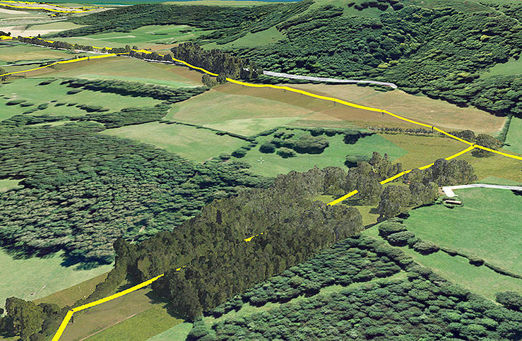
Bluesky has completed a multi-million pound aerial mapping project to assess the impact of vegetation on the electricity network of East Anglia and the South East of England. Working on behalf of UK Power Networks, Bluesky undertook the largest ever combined laser mapping and aerial photography survey commissioned by an electricity distribution network operator in the UK — some 34,000 square kilometers.
The laser mapped (LiDAR) data and aerial photographs were then analyzed to assess the proximity of vegetation to the overhead power lines in order to create a proactive three-year vegetation management program. Bluesky worked in partnership with ADAS, an agricultural and environmental consultancy, to complete the project.
Dedicated survey planes equipped with a lidar mapping system and aerial survey equipment flew the whole of the South East and East of England. Capturing millions of individual laser mapped height measurements and approximately 310,000 aerial images in just over three months, Bluesky successfully completed the unprecedented data capture element of the project within tight project deadlines, in challenging weather conditions and in adherence with strict Air Traffic Control restrictions.
The 80 terabytes of raw data was then processed and analyzed to identify which overhead line spans had vegetation infringement; for example the length of vegetation infestation along each span and its location and distance from the overhead line.
This information has now been incorporated into a 3D web portal that can be viewed from the desktop, enabling UK Power Networks employees to carry out virtual patrols of the network, saving time and reducing the risk of foot patrols, sometimes across difficult terrain including physical barriers such as rivers, ditches, livestock and numerous other potential hazards.
“This innovative £2.5 million project is of immense benefit to our customers and to the company,” said Nigel Hall, head of service development at UK Power Networks. “The risk-based tree-cutting program will help reduce tree-related power cuts for customers, with the additional benefit that it could be carried out without any disturbance to local landowners because it was done from the air rather than on foot.
“As a company it will help us get best value from our £19 million annual tree cutting budget, and the web portal will mean staff can carry out ‘virtual patrols’ from their desk, saving them time and reducing the potential hazards if they had had to walk the lines themselves.”
“Prior to commissioning the LiDAR and aerial mapping project, UK Power Networks undertook regular manual surveys as part of its assessment of network resilience, but the capture of LiDAR and associated aerial photography for the entire catchment area allows for evidence based decision making and long term planning, and provides a proven solution for other network operators,” added Rachel Tidmarsh, managing director of Bluesky.
Roy Dyer, Head of Arboriculture in ADAS and manager of the ADAS contribution to this contract said, “This has been a ground breaking contract. The combination of Bluesky’s technical ability and ADAS’ consultancy experience in managing vegetation near overhead lines enabled us to successfully deliver this challenging contract and improve the management and resilience of the overhead lines owned by UK Power Networks.”
Eos Positioning’s Arrow 200 Bluetooth receiver now supports Hemisphere’s Atlas correction service,
The Arrow 200 Bluetooth GNSS receiver by Eos Positioning Systems now supports the new Atlas H10 GNSS correction service. Using the H10 service, the Arrow 200 GNSS receiver is able to achieve 8-cm accuracy, in real-time, virtually anywhere in the world, the company said. The H10 corrections are delivered by geostationary satellite or via Internet connection.
The Hemisphere GNSS Atlas correction service, announced in June, is a real-time correction service that meets or exceeds existing correction services. It has three service levels, with H10 having the highest accuracy.
“Eos is proud to introduce the first GNSS receiver that supports the H10 service,” said Chief Technology Officer Jean-Yves Lauture. “It will allow our customers in every country in the world to have access to sub-decimeter real-time accuracy on all mobile platforms, including iOS, Android and Windows devices.”
The H10 correction service and the Arrow 200 support all active constellations including GPS, GLONASS, Galileo, BeiDou and QZSS, giving the user ultra-fast convergence time to real-time decimeter accuracy, Eos Positioning said.
The Arrow 200 employs long-range (1 km) universal Bluetooth connectivity so the user can interface to any brand of smartphone or tablet, whether it’s iOS, Android or Windows-based. The Arrow 200 has been optimized to run all day on battery power. The battery pack is field-replaceable and rechargeable separately. All Arrow receivers have been designed to meet IP-67 specifications for immersion in water and are completely dust-proof so they will survive in the harshest environments.
The Arrow 200 GNSS receiver with Atlas H-10 service is targeted at high-accuracy applications like GIS, environmental, agriculture, electric/gas/water utilities, surveying, machine control, and federal, state and local government.
Spatial Wave Inc. has released Field Mapplet Version 8.0 and Mapplet 8.0, which support ArcGIS 10.2 and 10.3.
Field Mapplet is a mobile solution for managing utility assets. It is designed to optimize utility workflows with features that are easy to use and implement, Spatial Wave said. The latest release includes enhancements in the mobile and console client, additional features to USA and Redline Extensions and Mapplet Manager, and support for Windows Server 2012R2, SQL Server 2014, and HTTPS secure service. A crucial upgrade of FM8.0 is that is supports ArcGIS 10.2 and 10.3.
With the core Field Mapplet framework, users can upgrade from FM Version 7.1 to 8.0 with minimal effort and downtime. FMv8.0 was built for day-to-day operations such as dispatching, navigation, routing, access to as-builts, engineering drawings, and redlining of location aware data. FMv8.0 is a configurable platform for building mobile applications such as customer requests, work orders and field data collections. FMv8.0 is touch-gesture-enabled and can be used on PCs, laptops and tablets.
Mapplet 8.0 is an advanced GIS viewer for viewing utility operational data and has unique capabilities to link to external data sources such as related engineering documents or tabular data. Users from an organization can gain access to business-critical data from the entire enterprise, including Customer Service, Field Operations, Engineering and Finance. The latest features include map tips, cluster symbology and heat maps. Mappletv8.0 supports ArcGIS 10.2 and 10.3 to enhance the user experience.
CartoPac International and EDM International have implemented a new transmission line inspection solution based on the CartoPac Software platform for the Western Area Power Administration. Western markets and delivers hydroelectric power within a 15-state region of the central and western U.S.
Western sought quotes for a commercial-off-the-shelf (COTS) utilities inspection software application that would provide a more efficient, integrated process and technology for improving Western’s transmission line inspection practices/process. Teaming with EDM, CartoPac was awarded the contract to deploy the CartoPac software platform, configure the COTS solution to meet specific needs for Western, and provide training to field personnel for use of the new system.
With the COTS solution, Western now has a fully integrated application within their Esri GIS system, leveraging Windows OS field computers for field inspection of transmission lines. The CartoPac solution provides Western linemen with complete, streamlined access to data needed in the field. Using ruggedized laptop computers, field personnel have access to a complete suite of tools, including GIS maps and digital inspection forms to perform the required inspection tasks in the field. CartoPac provides a streamlined process for data transfer in and out of the system, and provides a standardized, centralized application across all of Western. In addition, the new solution provides tools for GIS, foremen, and other key stakeholders to review, validate, and report on critical information.
Through the partnership established with EDM, CartoPac and EDM were able to provide a proven enterprise mobile technology, combined with expertise and experience in the electric transmission inspection and maintenance arena. EDM provided configuration and training of the solution using experienced subject matter experts, trained in configuration of CartoPac technology, with knowledge and experience in transmission line inspection and maintenance. The combination of the existing COTS CartoPac platform and EDM’s experienced personnel has created an electric industry offering with a highly flexible software platform and industry proven workflows.
CartoPac is hosting two webinars on the utility industry:
Trimble is partnering with unmanned aircraft system (UAS) manufacturer Multirotor service-drone, GmbH. The collaboration will allow Trimble to expand its existing UAS portfolio to provide its customers with additional solutions to choose from based on their aerial imaging project needs.
Multirotor service-drone, based in Germany, is a manufacturer of multi-rotor systems. Trimble will be Multirotor service-drone’s exclusive provider of multi-rotor vehicles for aerial mapping use in surveying, construction, mining, agriculture, oil and gas, and utilities. The combination of Multirotor service-drone’s stable and reliable platforms with Trimble’s industry-leading sensor technology and workflow efficiencies will provide customers with best-in-class solutions for aerial data capture.
Unmanned multi-rotor systems are powerful solutions for visually documenting smaller areas, vertical structures or environments where holding position is important. High-resolution imagery, orthophotos, terrain models and normalized difference vegetation index (NDVI) map deliverables created from multi-rotor data provide valuable information for the survey, engineering and agriculture industries that Trimble serves.
“We are very excited to partner with Multirotor service-drone. At Trimble we’re always looking for ways to meet our customer’s needs and enable them to solve the complex problems they encounter every day,” said Todd Steiner, product marketing director in Trimble’s Geospatial Division. “The collaboration will enable our customers to use a technology rapidly growing in popularity due to its flexibility and productivity.”