Tag: utilities

  • Trimble RTX Correction Services Now on Geo 7X Handhelds

    Trimble RTX Correction Services Now on Geo 7X Handhelds

    The Trimble Geo 7 series of rugged, high-accuracy GNSS handhelds will have RTK correction.
    The Trimble Geo 7 series of rugged, high-accuracy GNSS handhelds will have RTX correction. Photo: Trimble

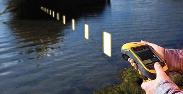
    Trimble’s RTX technology-based correction services — Trimble CenterPoint RTX, Trimble RangePoint RTX, and the new Trimble ViewPoint RTX — will be available for Trimble Geo 7X handhelds. Trimble made the announcement at Trimble Dimensions.

    Trimble RTX technology provides compatible GNSS receivers with correction services that significantly improve accuracy and reliability in obtaining positions worldwide. Geospatial professionals now have more flexibility to achieve the accuracy required by their highly mobile workflows in real-time, without being tied to a base station or local VRS network, Trimble said.

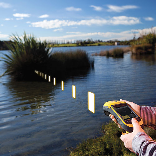
    Available worldwide through an IP connection where cellular communication is available, Trimble RTX offers geospatial professionals flexibility in where and when they are able to work. Operational efficiency and productivity in the field is improved by delivering real-time DGNSS corrections directly to the Trimble Geo 7X handheld. Field challenges, such as obstructed satellites and inaccessible locations, are also minimized with Trimble Floodlight and Trimble Flightwave technology options for the Trimble Geo 7X.

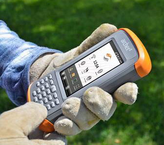
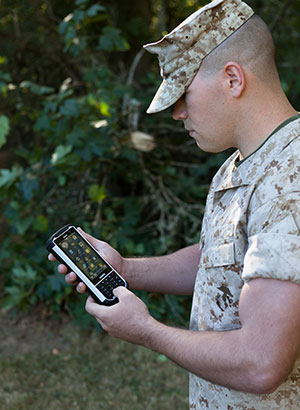
    The handheld solution is designed for a variety of industries — such as utility companies, municipalities, and environmental management agencies — in which workers are highly mobile and require a reliable, flexible data-collection and asset management solution.

    “We have eliminated the complexities of managing multiple correction sources across a large geographically dispersed project or organization,” said Alain Samaha, business area director of GIS and Software for Trimble’s Geospatial Division. “By offering RTX-based correction services, we simplify their work and deliver the accuracy that our customers require.”

    A choice of RTX correction services ranging from 4 centimeters to submeter-level horizontal accuracies is available. Customers can choose the appropriate Geo 7X handheld configuration with the RTX-based correction service that meets the accuracy level and capability required for their job.

  • LandWorks Adds Digital Parcel Polygon Data to Online Offerings

    LandWorks, Inc., a developer land management solutions, has added individual parcel polygons to its cloud-based offering of GIS-ready map products. Clients can now search, purchase and download digital parcel data sets with related attributes directly from the LandWorks website — in orders as small as a single parcel — at a cost of $2 per parcel.

    LandWorks developed the online parcel purchase application for industries and professions that need up-to-date surface land ownership information in their GIS. Some of the sectors already taking advantage of LandWorks’ online offerings include utilities, oil and gas, pipelines, real estate, banking, departments of transportation, renewable energy and mining.

    “The main benefits of buying parcel data from the LandWorks website are affordability and instant access,” said LandWorks President Jerry Bramwell. “Until now, digital map users had to order parcel polygon products by the county and then wait two to three weeks for delivery.”

    On the LandWorks website, there is no minimum or maximum purchase limit. The customer simply logs onto the parcel data page and searches for the desired parcel or parcels. The user may graphically select the desired parcels by searching and clicking on a map display or by uploading a spreadsheet containing the county tax parcel ID numbers.

    “The online database accessed through the LandWorks website contains parcel data for most of the United States,” said Bramwell. “This data comes from county assessor files or is manually digitized from paper plats and is updated quarterly.”

    The LandWorks site keeps track of desired parcels during the search process. When the user is ready, the website reports the number of parcels that have been selected and their total cost calculated at $2 per parcel. The user can add or delete parcels as desired. The user then decides to purchase the parcel polygons in either NAD 27 or NAD 83 map datum. Prior to purchase, the site gives the user the option of receiving the digital data sets in Esri shapefile or file geodatabase format. Each parcel polygon is delivered with key attributes — parcel number, parcel address, owner name/address, and official legal description.

    The digital parcel polygons come ready for download directly into Esri ArcGIS software as well as other popular mapping systems such as IHS Petra, IHS Kingdom and LMKR GeoGraphix.

  • Juniper’s New Rugged Handheld Designed for Data-Collecting Efficiency

    The Allegro 2 by Juniper Systems. Photo: Juniper Systems
    The Allegro 2 by Juniper Systems. Photo: Juniper Systems

    Juniper Systems announced its newest rugged handheld computer, the Allegro 2, at the InterGeo 2014 trade show, held September 7-9 in Berlin. The handheld is the latest in the company’s Allegro product line, “with every bit of reliability,” the company says, but now with some major advancements.

    According to Juniper Systems, the Allegro 2 was designed for data-intensive applications, with meticulous attention paid to the engineering and design of the handheld to maximize efficiency and precision, both of which are critically important to high-volume data collection.

    Compared to the Allegro 1, the Allegro 2 has a newly designed keyboard in a QWERTY and numeric layout, with large, glove-friendly buttons for rapid — even non-visual — data entry. The new handheld features a custom Sun-to-Shade display that is 20 percent larger than the previous Allegro. It offers excellent visibility in any lighting conditions, the company said.

    The Allegro 2 is powered by an Overtime Technology battery, providing a 20+ hours of runtime. Its touchscreen uses capacitive technology, providing excellent durability, as well as crystal-clear imagery and greater sensitivity to touch, Juniper Systems said. The Allegro 2 has significantly enhanced GNSS performance, extended Bluetooth range, camera and video options, and a more powerful processor than the Allegro 1.

    “The Allegro 2 is our next-generation product, and it includes all of the latest enhancements available in its sister product, the Archer 2,” said John Florio, product manager at Juniper Systems. “The Allegro 2 was built from the ground up, based on user feedback on the jobs they have to do. Whether the customer is grading lumber in a log scaling yard, running a robotic total station, or performing a close-interval pipeline survey, the Allegro 2 is the best solution for the field today.”

    The Allegro 2 is scheduled to begin shipping in November.


  • Altus, Entegra Combine to Provide Tough Tablet with RTK Positioning

    The APS-GeoPod. Photo: Altus Positioning Systems
    The APS-GeoPod. Photo: Altus Positioning Systems

    Altus Positioning Systems, a Septentrio company, has integrated its APS-GeoPod product with Entegra Technologies’ Crossfire Pro Tablet. This collaboration, targeting the oil and gas, survey, GIS and transportation industries, provides a high-performance tablet-based solution for enabling ultra-precision RTK of sub-meter or centimeter accuracy.

    Altus is showcasing the APS-GeoPod and Crossfire Pro tablet, along with the full range of Altus products, at booth A1.060 and outside Booth FG.006 at InterGeo 2014 being held this week in Berlin, Germany.

    According to Altus CEO Neil Vancans, the Altus APS-GeoPod and the Entegra Crossfire Pro Tablet provide a combination of precision, performance and features that make it ideal for energy services, land surveys and other GIS-related applications.

    APS-GeoPod is a compact GPS/GLONASS RTK and DGNSS receiver that adds high-precision RTK positioning to USB-compatible tablet PCs. “This unique product gives users the convenience of adding RTK precision to any on-board application on mobile devices geared to the field service professional,” Vancans said.

    The Entegra Crossfire Pro tablet. Photo: Altus Positioning Systems
    The Entegra Crossfire Pro tablet. Photo: Altus Positioning Systems

    APS-GeoPod features include:

    • Compact dual-frequency GNSS module
    • Low power consumption (<1 Watt)
    • USB 2.0 interface
    • Internal L1 GPS/GLONASS antenna
    • NMEA integration with GIS software

    The Crossfire Pro tablet features the multi-touch interface and communication capabilities of smartphones, the large display and ergonomics of consumer tablets, and the daylight-readable screen and durability of rugged tablets. Safety features include UL 1604 Class I/Division II certification for operation in hazardous locations. To users, Crossfire Pro delivers a customizable tablet for exacting daily activities, resulting in greater efficiencies, response times, productivity and customer service levels, the companies said.

    Crossfire Pro tablet features include:

    • ADAPTIVE PERFORMANCE — Powerful, latest-generation processors, wireless communications, connectivity, and outdoor-viewable displays
    • ADAPTIVE EXPANSION — Standard and custom expansion modules — tailored to suit your workflow
    • ADAPTIVE CONNECTIVITY — Flexible user interactivity, including multi-touch displays (finger, glove and stylus), configurable I/O ports, clamshell keyboard and smart docking stations
    • ADAPTIVE RUGGEDIZATION — Variations in ruggedness to stand up to drop, shock, moisture, dust, temperature, and more.
  • Carlson Software Introduces Surveyor2 Data Collector at InterGeo

    Carlson-Surveyor2-SmallA Photo: Carlson Software
    Photo: Carlson Software

    The Carlson Surveyor2, the newest model of Carlson Software’s Carlson Surveyor line of data collectors, was launched at the InterGeo Trade Show in Berlin this week.

    The handheld surveyor is on display at Carlson’s Stand 1.037, Hall 1.1, at InterGeo.

    Fast, durable and more powerful, the Carlson Surveyor2 is ruggedized, with an IP68 water and dust-resistant ingress rating. Still weighing two pounds, the Carlson Surveyor2 offers increased program memory (now 512MB) and increased non-volatile data storage (now 8 gigabytes), and a 1.0-GHz processor to provide the speed surveyors need in the field. It comes equipped with significantly increased Bluetooth range, up to 1500 feet when paired with a class I device. 

    The Surveyor2’s QWERTY keyboard eases data entry and is designed to be workable even for those with large hands or wearing gloves. The backlit keys and larger, brighter display screen allow users to work effectively in all lighting conditions.

    “Not only did the Surveyor2 retain the durability of its predecessor, but its higher-resolution, easier-to-read display screen also comes with scratch-resistant glass,” said Bruce Carlson, president and founder of Carlson Software. “An added convenience is its enhanced battery life — up to 20 hours.”

    The Surveyor2 has kept its easy-to-grip design, being thinner front to back than other data collectors when resting on a table top. The computer runs on Windows Mobile 6.5.3 and Carlson SurvCE 4.0 can be included. SurvCE is the powerful data collection software used around the world.

    The Surveyor2 is designed for surveying, stake out, construction layout and GIS mapping. The easy-to-use, tab-based menu and advanced graphics in Carlson SurvCE 4.0 enhance the Carlson Surveyor2’s usability. Options include an integrated GSM cell modem for real-time connectivity, an integrated 5 MP camera with LED illuminator that doubles as flashlight, and a mapping-grade GNSS receiver.

  • Juniper Systems, Soil Instruments Partner on Geotechnical Monitoring

    Soil Instruments Limited has partnered with Juniper Systems Limited to provide a geotechnical monitoring system using rugged computers and geotechnical engineering instrumentation to improve field activities in the structural and earthworks industry.

    Pairing Juniper Systems’ Archer 2 rugged field computer with Soil Instruments’ Digital Inclinometer Systems provides field engineers with a robust measuring and data collection system, the companies said.

    Soil Instruments’ Digital Bluetooth Inclinometer Systems are now exclusively using Juniper Systems’ Archer 2 rugged computer, which provides superior readings and data capture, Soil Instruments said. Soil Instruments’ inclinometers are specially designed instruments that provide high accuracy and resolution measurement for the monitoring of structural and earth deformations, movements or settlement.

    “The rugged Archer 2 handheld computer pairs beautifully with Soil Instruments’ Digital Inclinometers, providing more accurate readings and data capture than could ever be achieved previously in this industry,” said Simon Bowe, general manager of Juniper Systems Limited.

    Juniper Systems’ Archer 2 rugged computer is connected to the inclinometer system via Bluetooth wireless technology. Within the borehole an angular reading is produced by the engineer via the Read button on the Archer 2 screen, which triggers the inclinometer sensors to take the reading.

    Those readings are then instantly transmitted via the Bluetooth connection to the Archer 2, captured on-screen and saved in the Archer 2’s database, to be reviewed for accuracy or other needed data measurements. Long days of field work remain productive because of the 512MB of RAM and 8GB of flash storage in the Archer 2.

    Data can also be transmitted back to base quickly and accurately via the 3.75G modem in the Archer 2, an action which many other inclinometers cannot complete. At the end of the day, data can be downloaded or transmitted for subsequent comparison against all previous borehole runs, allowing analysis of lateral ground movements over time.

    “Soil Instruments has found the perfect field computer to match with our Digital Inclinometer Systems”, said Mike Ziolek, sales and marketing director for Soil Instruments. “The Archer 2 really gives our customers an edge by providing field readings more quickly and clearly than any other inclinometer system.”

    The physical features of the Archer 2 and the Inclinometer Systems are highly compatible. The Archer 2’s IllumiView high-visibility display is extra large, incredibly bright, and overpowers glaring sunlight. The backlit LCD easily adjusts to either portrait or landscape orientation, and is glove-friendly and extremely scratch-resistant.

    The Archer 2 has ultra-rugged construction with IP68 protection against water and dust, and is shockproof against multiple drops. The intelligent Li-ion battery can operate up to 20 hours on one charge and is hot-swappable in the field. The high-sensitivity GPS/GLONASS/SBAS receiver is highly useful for field work.

    The ruggedness of the Archer 2 compliments the secure connections on Soil Instruments’ Inclinometer Systems. The inclinometer probes are mounted to a cable using an advanced waterproof moulding compound, which eliminates field connectors. This means that no on-site connectors get broken or contaminated while working in the field.

    Juniper Systems Limited will be demonstrating its superior, rugged handheld computers at InterGeo at Messe Berlin, Germany, October 7-9, in Hall 2.1 on Stand A2.039.

  • Juniper Systems, Effigis Provide Sub-Meter GPS Accuracy

    Juniper Systems, Effigis Provide Sub-Meter GPS Accuracy

    The Juniper Archer 2. Photo: Juniper Systems
    The Juniper Archer 2. Photo: Juniper Systems

    Rugged handheld manufacturer Juniper Systems and Effigis, a geomatics solutions provider, have partnered to provide a powerful solution to capture and post-process GPS data to attain sub-meter accuracy.

    Effigis’ OnPOZ Precision Positioning Software suite takes advantage of the superior GNSS performance of Juniper Systems’ Archer 2 rugged handheld to collect high-accuracy GPS data. First, EZTag CE software is used on the Archer 2 to capture GPS field data points. The data is then sent to a desktop computer, where EZSurv Post-Processing Software automatically post-processes the data to achieve results with sub-meter accuracy. EZSurv removes the hassle of post-processing, requiring the click of a button to run, the companies said.

    Juniper Systems’ Archer 2 is ruggedized, enabling it to perform well as a data-collection tool in any environment, while the enhanced GNSS receiver provides a reliable signal, even in heavy tree canopy.

    “Achieving sub-meter GPS accuracy typically has two barriers in people’s minds. One, the hardware and software are usually expensive. And two, the thought of post-processing makes a lot of people cringe. The OnPOZ suite, on the other hand, is powerful, yet comes at a price people are comfortable with, and it takes care of all the post-processing for you,” said Jim Benson, Utilities & Public Services Market Manager at Juniper Systems. “The Archer 2 handheld really finishes off the whole package. Its GNSS receiver is outstanding, performing reliably even under trees, and the handheld is so well designed, you can count on it to work well in any environment.”

    To learn more about the Archer 2 and OnPOZ Precision Positioning Software suite, download the brochure.

  • Handheld Group Launches Nautiz X8 Rugged Device

    Handheld Group Launches Nautiz X8 Rugged Device

    handheld-nautiz-x8-ultra-rugged-ip67-mapping-W Photo: Handheld Group
    Photo: Handheld Group

    Handheld Group, a manufacturer of rugged mobile computers, has launched the Nautiz X8 rugged PDA. The Nautiz X8 is a handheld computer with superior processing power, screen performance and battery life, the company said. It is built for tough field conditions primarily in GIS, land surveying, public safety, forestry and the military.

    handheld-nautiz-x8-ultra-rugged-military-rugged-W Photo: Handheld Group
    Photo: Handheld Group

    The Nautiz X8 is built to enable efficient and reliable data collection in tough environments. It has an IP67 ingress protection rating, which means it offers complete protection against dust and sand and can withstand immersion in water. It also meets stringent MIL-STD-810G military test standards for overall durability and resistance to humidity, shock, vibration, drops, salt and extreme temperatures.

    The Nautiz X8 features a high-performance Texas Instruments 4470 dual-core 1.5 GHz processor. It has 1 GB of RAM, 4 GB of iNAND Flash and a 5200 mAh Li-ion battery that lasts up to 12 hours on a single charge. It comes with a choice of operating systems — Android 4.2.2 or Windows Embedded Handheld 6.5.3.

    The device has a large 4.7-inch ultra-bright capacitive multi-touch screen with chemically strengthened Asahi Dragontrail glass, offering users brightness and protection in any field condition. The unit has an ergonomic design and weighs 490 grams (17.3 ounces).

    The Nautiz X8 has a dedicated u-blox GPS receiver, Bluetooth 2.0 and 802.11b/g/n WLAN functionality, as well as connectivity through GSM/UMTS or CDMA phone data transmission. A built-in 8-megapixel camera with autofocus and an LED flash lets users capture visual data quickly and easily. This handheld also features an open architecture and an extension cap system that allows for additional hardware connections such as sensors, radios and other add-ons.

    Orders for the new Nautiz X8 can be placed immediately. First deliveries will begin in November.

    The Nautiz X8 rugged handheld will be shown first at WEFTEC in New Orleans, followed by InterGeo in Berlin.

  • LandWorks Adds Linear Project Routing to Online Property Mapping Service

    LandWorks Inc., a developer of land-management solutions, has added linear project mapping capabilities to its online Web AutoMapper service, which converts land legal descriptions into GIS-ready map polygons. Web AutoMapper clients can now download digital parcel polygons with ownership information for every property crossed by a linear right-of-way project.

    The linear mapping capability in Web AutoMapper facilitates the planning of any linear infrastructure development project – pipelines by energy companies, electric transmission lines by utilities, roads and highways by departments of transportation, and buried fiber networks by telecommunication companies.

    “Web AutoMapper makes it faster and less expensive to map a proposed right-of-way or corridor project,” said LandWorks President Jerry Bramwell. “In minutes, project planners can download all of the digital parcel and land ownership information needed to select the safest and least costly route.”

    To use the service, the client logs onto Web AutoMapper and creates an account. The user then uploads a shapefile of the proposed linear project route from their GIS or mapping software. Web AutoMapper prompts them to enter start and end points for the route. Customers are also given the option of having their route mapped with or without a buffer on either side.

    Within minutes, Web AutoMapper overlays the route onto the nation-wide tax parcel grid developed by Digital Map Products of Irvine, California. Web AutoMapper then provides an onscreen map showing every property crossed by the route or within the user-selected buffer around the route. Paying with credit card or a customer account, the customer downloads the Digital Map Products parcels for only those properties affected by the proposed route. The parcel polygons are delivered in either shapefiles or as a file geodatabase for seamless ingest into the GIS or other mapping software.

    Also included in the Web AutoMapper deliverable is a Line List Report identifying every property crossing in order from the starting to end points of the proposed route. Both the parcel polygons and Line List Report contain important attributes for each property, such as landowner and address details, obtained from county tax records.

    “The linear mapping capability in Web AutoMapper serves as an easy-to-use cost-estimating tool for major infrastructure development projects,” said Bramwell. “The planner receives all of the land ownership information that will be needed to acquire rights-of-way for the project.”

    In many cases, the ownership information in the parcel file will help planners identify certain types of properties — such as hospitals or schools — where rights-of-way may be impractical or simply too costly to acquire, said Bramwell. This allows the planners to look for less expensive alternatives while the project is still in its early phases.

    Some linear projects require the developer to notify land owners within a certain distance of the proposed route. The buffering option in Web AutoMapper enables the planners to easily obtain land ownership information for properties within the regulated proximity to the line.

    LandWorks introduced Web AutoMapper in 2013 as a fast and easy method of processing many types of standard property descriptions and converting them into digital map polygons. The cloud-based application is used extensively by organizations that must manage large tracts of land and keep property records up to date for activities related to oil and gas, renewable energy, mining, banking, utility, pipeline, state/local government, transportation, telecommunications, water and real estate sectors.

  • CartoPac 5.0 Offers Workflow Manager, Windows 8 Optimization

    CartoPac International Inc. has announced a major new release of the CartoPac Mobile Platform. CartoPac 5.0 extends the mobile platform with support for Windows 8 and introduces the CartoPac Workflow Manager, which provides a structured process to manage the use of geospatial data across the enterprise.

    CartoPac will demonstrate the applications and technologies of Version 5.0 in the free CartoPac Mobility Webinar Series beginning on September 30.

    The CartoPac Platform is a configurable suite of field and office tools designed to maximize the productivity of crews as they digitally map, inventory and inspect critical assets using GPS-enabled mobile devices. Seamlessly integrating with the Esri ArcGIS Server, CartoPac is used extensively by oil and gas companies, pipeline operators, electric utilities, state/local governments and environmental engineering firms to populate the enterprise GIS and asset-management systems with captured infrastructure information.

    The new CartoPac Workflow Manager (CWM) in CartoPac 5.0 provides organizations with a structured workflow to view, edit, validate and approve asset data as it moves from the field back into the enterprise. CWM ensures that individuals responsible for data are notified as it comes into the organization so they can incorporate the data into systems related to work-order fulfillment, risk analysis, integrity modeling and other asset management processes.

    CartoPac developed CWM for the management of heavily regulated assets in the field, such as gas pipelines and electric distribution infrastructure. A module within the CartoPac Server, the CWM extension creates an audit trail of all the edits and modifications made to the data sets that represent the monitoring and maintenance of real world assets in the field.

    “CartoPac Workflow Manager fills the gap between data collection and enterprise asset management systems to enable organizations to maximize the value of their data,” said CartoPac CIO Scott Crouch. “CWM enables organizations to show regulators they have a structured process for tracking and responding to the conditions of their critical assets and has proven to be key component for assisting companies with their regulatory compliance and integrity management programs.”

    Further expanding the capabilities of the CartoPac mobile components, version 5.0 has been optimized for the Windows 8 operating system running on standard GPS-enabled laptop computers and tablet devices. This migration means that crews can use CartoPac to collect and manage asset data in the field on the same hardware devices they will use back in the office to run their daily business applications.

    “The attractive cost, integration with GPS and expanded performance of Windows 8 tablets and laptops will enable organizations to put more personnel into the field, ensuring that vital infrastructure is mapped, inventoried and properly managed,” said Crouch “Laptop/tablet-equipped maintenance personnel in the field will now be able to run CartoPac solutions on the hardware they already use for tracking repairs and closing work orders.”

    To demonstrate the advantages of enterprise asset management, CartoPac has launched the CartoPac Mobility Webinar Series, which will feature applications by electric and gas utilities and highlight new mobile technologies. The first webinar, “Applying New Mobile Technologies to Electric Utility Inspections,” will be presented with EDM International Inc., a Colorado electric utility services company.

    The free “Applying New Mobile Technologies to Electric Utility Inspections” webinar will be held on September 30, 2014, at 4:00 pm Eastern Time. To register, click here.

  • Trimble Enhances Cloud-based Software for Smart Water Infrastructure

    Trimble has introduced the latest version of its smart water infrastructure mapping and work management software — Trimble Connect version 1.8. The latest release of the cloud-based, geographic information system (GIS)-centric software includes a suite of applications that allow water, wastewater and stormwater utilities to visualize and efficiently manage their network maintenance and data collection activities.

    Trimble Connect software leverages Trimble’s GNSS rugged mobile devices and Esri’s GIS technologies to accurately map, locate and assess the condition of critical infrastructure assets, allowing utilities to keep their field infrastructure data up-to-date and accurate. Offered as a software-as-a-service (SaaS) subscription, the solution allows users to monitor asset operating conditions, manage leak repairs, reduce non-revenue water, deploy and inspect smart meters, lower potential threats to safety and health due to contamination and adhere to regulators’ reporting guidelines and requirements. Trimble Connect version 1.8 can be configured and deployed quickly on a variety of Trimble and non-Trimble mobile devices, laptops, tablets and smartphones, including Apple iPads, iPhones, Android, Windows and Windows Mobile devices to automate field workflows and eliminate paper-based maps.

    Trimble Connect utilizes the latest Esri ArcGIS 10.2.2 for Server, Mobile and ArcGIS Online basemap services. The software is designed to automate a variety of specific water and wastewater industry workflows through individual “apps” offered within the product and as part of a subscription. The new version provides standard core apps including Map Book, Manhole Inspector, Leak Repair, Hydrant Inspector, Valve Inspector, Meter Changeout, Incident Repair, Water Mapper, Wastewater Mapper and Stormwater Mapper. In addition, an optional partner app developed for American Flow Control (AFC) hydrant and valve data collection, “AFC Mapper,” can be purchased from AFC and their distributors for use with Trimble rugged handhelds.

    In addition to the standard core apps, Trimble Connect version 1.8 includes:

    • Full offline mobile support including GIS data for Android, iOS, Windows Mobile and Windows 7/8 platforms
    • Esri ArcGIS Online (AGOL) support to create and share Web Maps using data collected in Trimble Connect
    • Work management support for single and multi-asset work orders on all supported platforms
    • Enhanced workflows for asset inspection and condition assessment
    • Embedded business rules to define failed inspections or ones that need review
    • Enhanced workflows for asset mapping and data collection
    • Support for the Trimble Geo 7 series rugged mapping handheld and integrated Laser Rangefinder
    • Standard dashboards with each of the core apps
  • Trimble Announces Land-Based 3D Piling Application for Mixed Fleets

    Trimble Announces Land-Based 3D Piling Application for Mixed Fleets

    DPS900_Trimble
    The DPS900 Piling System

    Trimble has introduced the DPS900 Piling System, a dedicated land-based 3D machine control system for a variety of piling machine makes and models. The accuracy of the system allows piling contractors to increase operational efficiency and reduce costs for building structural foundations, retaining walls, coffer dams, and solar or wind farm installations.

    “The DPS900 Piling System can transform the way piling contractors work,” said Alan Sharp, business area director for Trimble Heavy Civil Construction. “Without DPS900, the process is manual and often error prone. With the DPS900 system, contractors can take advantage of accurate positioning and automated reporting to ensure machines are being utilized efficiently.”

    The DPS900 Piling System reduces surveying costs associated with staking and as-built checks. In addition, the system can increase on-site safety by reducing the number of people around machines, pilings and foundations. Accurate positioning in DPS900 can ensure navigation time between piles is reduced, resulting in increased piling time to maximize production and revenue per day.

    Built-in, automated quality assurance and quality control reporting includes capture of start and end positions, time and elevation, as well as actual embedment depth, blow count reporting, and inclination and orientation control. In addition, unique system logins allow managers to filter reports by operator for better accountability, production optimization and forecasting.

    Business Center–HCE office software by Trimble is used to create pile plans in the office, and allows for integration with data prep, estimating and reporting functions. Piling machines can be connected to the office using Trimble Connected Site solutions for wireless data transfer and GNSS corrections. In addition, machines can be tracked and monitored using VisionLink for location, hours and utilization information.

    The new Trimble DPS900 Piling System is available now in Australia, Europe, North America, Chile and South Africa through Trimble’s SITECH Technology Dealer Channel.