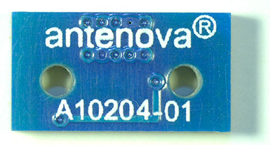
The Brevis GNSS antenna is the latest addition to Antenova’s gigaNOVA family of miniature antennas. The small antenna is designed to be used in portable handheld devices that have GNSS receivers — for example, in devices and applications that have a tracking capability or location accessories such as in transport, navigation, wearables and eHealth.
The multi-GNSS antenna is designed for embedded applications, with a high efficiency-to-size ratio. It is intended for use in applications where there is no ground beneath the antenna. It has near omni-directional characteristics which will provide good performance for any device.
The Brevis operates with the following GNSS bands: GPS, GLONASS, Galileo and BeiDou. Brevis GNSS is a low-profile, small-footprint antenna designed for surface-mount device (SMD) mounting, so it can simply be placed on a printed circuit board (PCB) to add wireless connections to any device.
Full technical specifications for the Brevis GNSS antenna and contact details for regional distributors are available on Antenova’s website.
Antenna maker Maxtena has launched an L1 L2 GPS/GLONASS active helix antenna for GNSS satellite applications. The new antenna M1227HCT-A2-SMA antenna will replace its predecessor the M1227HCT-A-SMA antenna, which made its debut in 2010.The new antenna has been mechanically upgraded. It is packaged in a high-quality, durable IP67/68 sealed radome housing and terminated with a gold-plated SMA connector for RF feed/input and DC bias/power typically powered from the applications’ GNSS RF module.
The M1227HCT-A2-SMA active helix design features Maxtena’s patented compact and light-weight Helicore Quadrifilar antenna technology and a built-in dual-stage low noise amplifier (LNA) and filtering, offering up to 30-dB gain for GNSS applications that use GLONASS and GPS in one radome housing with a single 50-Ohm SMA connector.
The tiny antenna is designed for applications across various markets such as UAVs, GIS and wearable GNSS.
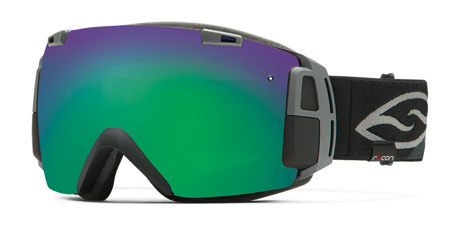
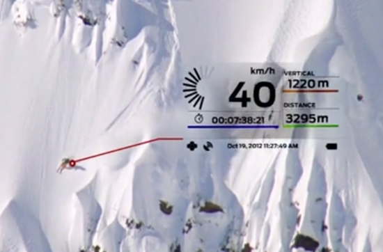
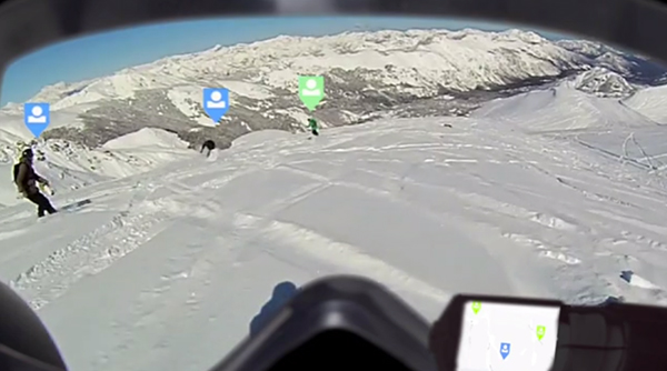
Sporting goods maker Smith Optics is offering I/O Recon goggles for winter sports enthusiasts, which combine Smith’s premium anti-fog lenses with GPS and Bluetooth technology. A heads-up display is integrated into the frame design, allowing users to log and view information without taking their eyes off the powder.
According to Smith Optics, the frame design maximizes field of view. With the heads up display, skiiers and snowboarders can see the speed they’re going, the height of their jumps, and track and follow their friends on the slopes. The Bluetooth allows connection to a smartphone.
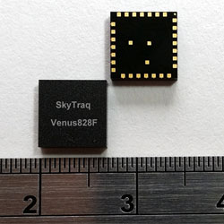
The SkyTraq Venus828F GNSS receiver module. Photo: SkyTraq Technology
SkyTraq Technology has introduced a stand-alone multi-GNSS receiver module in a compact 7 x 7 millimeter form factor, the Venus828F, designed with a sensor hub function for wearable and “Internet of Things” (IoT) applications.
The Venus828F is capable of communication with multiple satellite systems and tracking up to 28 satellites concurrently, SkyTraq said. The compact LGA module integrates all the necessary components for wearables and IoT, forming a complete working GNSS receiver, including GNSS chipset, 0.5ppm TCXO, Flash memory, LDO regulator, DC/DC switching regulator, and passive components. It only requires external antenna and power supply to output accurate position, velocity, and time information in standard NMEA-0183 format, enabling ease of use and fast time to market, Skytraq said.
The Venus828F features low power consumption, a 29-second cold start TTFF, -165 dBm tracking sensitivity, 10 nsec 1 PPS timing accuracy, on-board geofencing, 8 Mbit – 512 Mbit external SPI Flash data logging, and an industrial operating temperature range of -40C +85C. It has an UART and I2C interface for flexible connection to the host processor.
Via SPI and I2C connection, data from MEMS sensor can be calculated by Venus828F using sensor-hub-enabled firmware, offloading computation from the host processor. Engineers can concentrate on their wearable and IoT applications instead of spending hundreds of hours reinventing the wheel developing sensor-fusion algorithms, according to SkyTraq.
“Fast-acquisition high-sensitivity multi-GNSS chipset hardware are just becoming available in recent years, the internal firmware supporting multi-GNSS typically are not as fully optimized as GPS-only firmware that has matured for more than a decade to allow ROM codification with optimal performance for any existing GNSS chipset vendors; the multi-GNSS firmware is still being continuously improved over time,” said Michael Chung, VP of sales and marketing, SkyTraq. “By offering Venus828F multi-GNSS receiver module with Flash memory, it’s shipped with the latest, best-performance firmware. It is also later upgradeable in the field if the customer’s design allows. Targeting very high volume, cost-sensitive wearable and IoT applications, Venus828F is offered at price comparable to crystal-based ROM GPS modules on the market, setting a new benchmark in terms of performance, size, and cost for multi-GNSS receiver modules.”
An engineering sample, datasheet, and reference design for the Venus828F are available now.
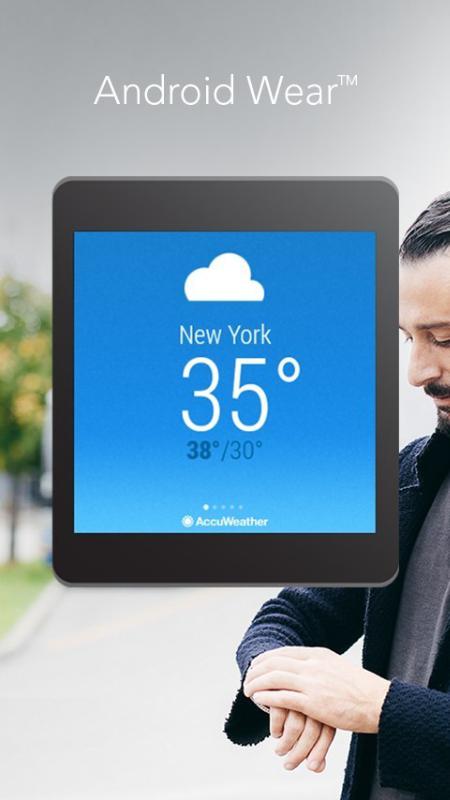
AccuWeather App for Android Wear (PRNewsFoto/AccuWeather)
The AccuWeather app for Android is now available for Android Wear, providing users with up-to-the-minute weather information wherever they go. Android Wear is the Android platform for wearables such as smartwatches. The app is available through the Google Play store.
AccuWeather’s app for Android Wear features AccuWeather MinuteCast, a global minute-by-minute precipitation forecast for a person’s exact street address or GPS location. AccuWeather MinuteCast includes precipitation type and intensity, as well as start and end times for precipitation, and gives users by-the-minute precipitation forecasts for the upcoming two hours. The GPS technology that localizes the weather to the user’s location is protected by patents in the United States and many of the major countries around the world, AccuWeather said.
In addition to AccuWeather MinuteCast, AccuWeather for Android Wear and for Android smartphones and tablets provides users with severe weather alerts, hourly forecasts, and current conditions.
“This is an exciting opportunity for AccuWeather to deliver weather information in innovative new ways to users,” said Steven Smith, chief digital officer of AccuWeather, Inc. “As the global weather leader, we provide weather forecasts wherever, whenever, and however our users most want them. Easy access, hyper localization, ease of use, and the superior accuracy that is the hallmark of our organization, help our audiences everywhere make decisions and improve their lives.”
AccuWeather MinuteCast is available for the contiguous United States, Canada, Japan, Ireland, France, Germany, Belgium, Switzerland, Netherlands, Luxembourg, the United Kingdom, and parts of the Czech Republic, with additional locations to come.
AccuWeather for Android Wear, and for Android smartphones and tablets, is available from Google Play.
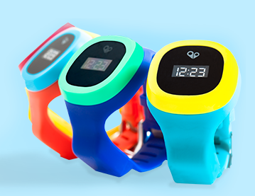
The hereO cellular GPS watch for kids will be officially unveiled at the 2015 International CES, being held in Las Vegas this week. Designed for children ages three and up, the hereO works in sync with a mobile app to provide real-time location sharing, safe-zone alerts, and group messaging, allowing parents to monitor their children’s safety and whereabouts at all times directly on their mobile phones or desktop computers.
The engineers at hereO miniaturized components to make the watch fit children’s wrists, the company said. The watch comes in a variety of bright and colorful water resistant designs to appeal to children. For parents, the hereO Family App for smartphones/tablets (iOS and Android) and desktops provides real-time location information on all family members and loved ones, plus location history, live-updates, panic alerts, safe-zone definition, and more.
“CES is a crucible of amazing minds, emerging ideas, and groundbreaking new technology; it’s the Mecca for today’s most inspired innovators,” said hereO Co-Founder and President Daniel Ivesha. “After three years of developing and perfecting our prototype, we couldn’t think of a better place to debut hereO, the world’s smallest cellular-connected GPS tracking watch for kids, which we believe is not only a game-changer in child safety technology but in the way families stay connected.”
Features include:
hereO LOCATION: Parents can locate their child anytime, anywhere. Historical locations are also available so parents can track where their child have been throughout the day.
Wi-Fi ENABLED: Wi-Fi allows indoor tracking whenever an indoor map is available. When indoor mapping is unavailable, an indoor confirmation will be sent to the parent’s smartphone.
SAFE-ZONE ALERTS: Parents can create Safe Zones for frequently visited areas (kindergarten, office, etc.) and are notified when their child arrives or departs from that location.
PANIC ALERT: In case of an emergency, children can use their hereO watch to send a panic alert that immediately notifies family members of their location.
TAMPER ALERT: Parents receive an alert when any authorized person tries to remove the watch.
EMERGENCY TRACKING: In emergency situations, parents can turn on real-time tracking to facilitate locating the child.
TIME DISPLAY: Time is displayed on a beautiful e-ink display.
USB charger: Built-in USB connector allows portable charging. Simply plug the hereO watch into any USB port to charge and to get firmware updates.
LONG BATTERY LIFE: With our standby mode, the hereO watch can last up to 60 hours.
BUILT-IN SIM: Each hereO watch is equipped with a built-in SIM card that works in over 120 countries, making it the perfect travel companion.
The hereO watch retails for $179, which includes a three-month subscription to the hereO Family App. Thereafter, a monthly fee of $4.95 applies.
At CES, the hereO watch is at booth #74545 (Tech West: Sands Expo at The Venetian).
Record-Breaking Year Ahead: Industry Revenues to Reach All-Time High of $223.2B in 2015
Revenues for the consumer electronics (CE) industry are projected to grow three percent in 2015 and to reach an all-time high of $223.2 billion, according to The U.S. Consumer Electronics Sales and Forecasts, the semi-annual industry report released today by the Consumer Electronics Association (CEA). The total revenues forecast was announced by CEA President and CEO Gary Shapiro during his opening remarks today at the 2015 International CES, running January 6-9 in Las Vegas.
CEA’s consensus forecast reflects U.S. factory sales to dealers and covers more than 100 CE products. The twice-annual report serves as a benchmark for the CE industry, charting the size and growth of underlying categories.
Emerging Technologies
The 2015 forecast projects that revenue for new, emerging product categories is expected to double, growing 108 percent year-over-year in 2015. These new technology categories include unmanned systems (unmanned aerial vehicles, unmanned vehicles and home robots); wearables such as health and fitness devices, smartwatches and smart eyewear; IP cameras; 3D printers; 4K Ultra-High Definition televisions; and connected thermostats.
While the emerging product categories represent less than five percent of the entire CE industry revenue forecast, they are expected to contribute almost $11 billion to overall CE revenue in 2015.
“Our forecast underscores that consumers’ love affair with technology shows no signs of slowing any time soon,” said Shapiro. “Consumer technology is all about continued innovation. In the blink of an eye, consumer demand has taken off for emerging categories such as wearables, unmanned aerial vehicles and 4K Ultra HD — categories that were too small to track just three years ago. Expect to see these burgeoning categories, as well as innovations across the full spectrum of consumer technology, on display this week at the 2015 International CES.”
The Wearable Revolution
The wearable device revolution is a key category to watch in the coming years, and especially in 2015. CEA projects overall wearable unit sales will reach 30.9 million units (a 61 percent increase from last year) and generate $5.1 billion in revenue in 2015 (a 133 percent increase). CEA’s wearables category encompasses fitness activity bands and other health and fitness devices, as well as smartwatches and smart eyewear.
Health and fitness devices: Led by the popularity of activity tracking devices, health and fitness devices will lead unit sales among all wearables in 2015 with a projected 20 million units. Revenue is expected to surpass $1.8 billion in 2015.
Other mobile devices:
Smartphones: As the sales leader of the industry, smartphone unit shipments are projected to reach 169.3 million this year, up six percent from 2014. Additionally, smartphone revenues are expected to generate $51.3 billion in 2015, a five percent increase from last year. Particular growth will be seen in screen sizes between 5.3 inches – 6.5 inches.
Tablets: Unit sales of tablets are projected to reach 80.7 million this year, a three percent increase from 2014. Revenues for tablets will reach $24.9 billion this year, down one percent.
“Mobile connected devices have reached an equilibrium, stabilizing the steep climb these products have experienced in recent years,” said Shawn DuBravac, Ph.D., chief economist, CEA and author of CEA’s soon-to-be released book Digital Destiny: How the New Age of Data Will Transform the Way We Work, Live, and Communicate. “Overall, improving economic conditions, consumer enthusiasm for new features and product categories, competitive manufacturer pricing and several other dynamics now at play should make 2015 an especially significant year for tech.”
Other CE categories expected to enjoy positive growth in 2015 include audio, electronic gaming and laptops. Automotive electronics will see continued growth due to new vehicle sales in 2015, reaching $14 billion in revenue, a 3.3 percent increase.
The U.S. Consumer Electronics Sales and Forecast 2010-2015 (January 2015) is published twice a year, in January and July, reporting U.S. factory sales-to-dealers. It was designed and formulated by CEA to be a comprehensive source of sales data, forecasts, consumer research and historical trends for the consumer electronics industry.
Wi2Wi Corporation is releasing the W2SG0021i, a miniature GNSS module based on the CSR SiRFStarV chip.
The W2SG0021i is a high-sensitivity, low-power stand-alone receiver designed for portable applications. It can concurrently track multiple satellite constellations (GPS, GLONASS, BDS, SBAS, and is Galileo-ready) and has ultra-fast time-to-first-fix, a small form factor, and high receive sensitivity for a broad spectrum of OEM products, including machine-to-machine (M2M) and consumer wearables.
The module provides precision commercial-grade GNSS location identification over -40C to +85C. Measuring 7 x 7 millimeters, the W2SG0021i addresses the need for a cost-effective and high-performance GNSS module for major markets worldwide, the company said.
M2M and wearable markets require GNSS modules with high position accuracy, low power, and very small form factor, said Wi2Wi CTO and vice president of engineering Tony Fardanesh. Wi2Wi pushes these limits in its GNSS, Wi-Fi, and Bluetooth solutions, he said.
Precision location features and the small form factor of W2SG0021i enable Wi2Wi to penetrate into the GNSS market globally. Wi2Wi continues to invest in the research and development of high-precision connectivity solutions, timing devices and frequency controllers to the global customer base, said CEO Hans Black.
The W2SG0021i samples and development kit will be available in Q1 2015.
Wi2Wi designs, manufactures and markets miniaturized embedded wireless connectivity solutions (incorporating both hardware and software), high-precision timing devices, and frequency controllers for premium industrial/medical, avionics, home automation and government markets.
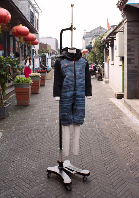
Dutch textile company ByBorre and its founder, fashion designer Borre Akkersdijk, have created the BB.suit — a wearable Wi-Fi hotspot with GPS, a music library, and an air purifier.
Version 1.0 of the suit, which has electrical threads woven into the fabric, was showcased at the SXSW music and film tradeshow in March, where a model’s location was shown on Google Maps, allowing anyone to locate the suit using its GPS data, and then upload songs to a 22Tracks platform.
Version 2.0 introduces an additional tech — an air purification system. Demonstrated at Beijing Design Week in September, the garment purifies the polluted air surrounding the wearer. According to Dezeen, designers Akkersdijk and Eva de Laat collaborated with Martijn ten Bhomer from the Eindhoven University of Technology, Daan Spangenberg Graphics, and StudioFriso to create the one-piece suit, which looks like an adult onesie.
“The BB.Suit started because everyone was talking about wearable technology, the bracelets, the glasses,” Akkersdijk told Dezeen. “We thought about how we could really integrate the electrical threads and sensors and not just stick them on.”
The electrical yarns are woven into the body and legs of the outfit, while the long sleeves and a hood are made from standard textiles. The air-quality sensor at chest level is connected to a hidden platform chip that tracks and transmits data counting the particles of carbon monoxide, methane and dust around the body. The chip is wired to a battery and a cold plasma node on the back of the suit.
You won’t be able to outfit yourself with the garment yet, as it was created as a step towards a connected wearable platform rather than a product to be marketed.
GPS World’s December cover story, “The Fashion Demands of Always-On,” discusses the chip architecture requirements of wearables. Read it here.
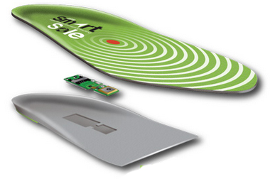
GTX Corp, a personal location wearables company, has entered a strategic partnership with Life Button 24, a division of World Wide Security Group and provider of life safety, dispatch and monitoring services since 1979.
Under the strategic partnership, GTX Corp will offer Life Button 24 services to its GPS SmartSole customers, providing 24/7 access to live dispatch operators that can assist caregivers when a loved one goes missing. The premium service will be offered through GTX on a monthly subscription basis as an add-on to existing monthly tracking service plans provided by GTX.
“Our GPS SmartSoles were specifically designed for caregivers to be able to react in real time to find a loved one who has wandered off,” commented Andrew Duncan, director of GTX Corp. “By partnering with Life Button 24, we will now offer our U.S. customers an enhanced level of service and extra layer of protection. The service will be able to provide a caregiver with the ability to contact a live person, who can assist in coordinating the successful search and rescue of the loved one, or assist in notifying the proper authorities if needed. By offering this service, we enable individual caregivers and assisted living staff, among others, with an additional level of 24/7 human response, when critical support is most needed.”
“Life Button 24 is thrilled to provide 24-hour emergency response services in partnership with the GTX Corp SmartSole GPS system,” said Jeff Katz, director of project development for Life Button 24. “Addressing wandering issues of individuals afflicted with Alzheimer’s and autism is a growing concern for the millions of families and caregivers. Life Button 24 looks forward to being part of a greater solution that delivers peace-of-mind through advanced tracking technology and customized emergency response services, which were designed specifically to support applications such as the GPS SmartSole.”
“With initial delivery dates for our GPS SmartSoles to consumers being confirmed next week and several pilot agreements with large organizations kicking off this month, the timing of this partnership with Life Button 24 couldn’t be better. “After several months of integrating and testing our platform and services and having socialized this new offering with some of our larger partners in law enforcement and the assisted living community, we are extremely excited to start offering this service and look forward to a successful partnership with the Life Button 24 team.” Commented Patrick Bertagna CEO of GTX Corp.
Ultra-Low-Power, High-Accuracy Location for Wearable GNSS Devices: From Host-Based to On-Chip
Photo: Steve Malkos, Manuel del Castillo, and Steve Mole, Broadcom Inc., GNSS Business Unit
As location penetrates smaller and smaller devices that lack memory and computation power, GNSS chips must reacquire the standalone capability that they shed when first going to small form factors such as phones. A new chip with a new architecture demonstrates navigation and tracking and avoids burdening its main processor with heavy software.
By Steve Malkos, Manuel del Castillo, and Steve Mole, Broadcom Inc., GNSS Business Unit
End users first experienced the amazing capabilities of GPS 12 years ago with early mass-market GPS devices. The focus was on navigation applications with specific tracking devices like personal navigation devices and personal digital assistants (PNDs, PDAs). With the advent of smartphones, GPS became a must-have feature. Other constellations were added to improve performance: GLONASS, QZSS, SBAS, and very recently, BeiDou. In the current phase, the focus is shifting to fitness applications and background location. This is not an insignificant change.
Always-on connected applications, high-resolution displays, and other such features do not improve battery life. This article describes new ultra-low-power, high-accuracy location solutions for wearables’ power consumption.
Impact of Always-On Connected Applications
New applications require frequent GNSS updates with regard to user position. Sometimes the application will be open and other times it will not. The chips need to keep working in the background, buffering information and taking predefined actions. The GNSS chips need to be able to cope with these new requirements in a smart way, so that battery life is not impacted. Saving power is now the name of the game.
Furthermore, GNSS is penetrating small devices: the Internet of Things (IoT) and wearables. They do not have the luxury of large resources (memory, computation power) as smartphones do. GNSS chips cannot leverage the resources in those devices; they need to be as standalone as possible. In summary, the new scenario demands chips that:
do not load device’s main processor with heavy software;
use less power while maintaining accuracy;
can be flexibly configured for non-navigation applications.
New GNSS Chip Architectures
The industry is designing chips to meet these requirements by including the following features:
measurement engine (ME) and positioning engine (PE) hosted on the chip;
accelerometer and other sensors directly managed by the chip;
new flexible configurations, duty cycling intervals, GNSS measurement intervals, batching, and so on.
These features require hardware and software architectural changes. The new chips need more RAM than that required for smartphones, as they must now host the ME and PE. Wearables and IoT devices are small, cheap, and power-efficient. They do not have large processors and spare memory to run large software drivers for the GNSS chip. In many cases, the device’s microcontroller unit (MCU) is designed to go into sleep mode if not required, that is, during background applications. Therefore, new GNSS chips with more RAM are much better adapted to this new scenario.
New chips must tightly integrate with sensors. The accelerometer provides extremely valuable information for the position update. It can detect motion, steps, motion patterns, gestures, and more. However, as a general rule, the MCU’s involvement in positioning should be minimized to reduce power consumption. For power efficiency, the new GNSS chips must interface directly with the sensors and host the sensor drivers and the sensor software.
Finally, new chips must adapt to different human activities as they are integrated into wearable devices. This is the opposite approach from past developments where GNSS development was focused on one use case: car navigation. Now they must adapt to walking, running, cycling, trekking, swimming, and so on. All these activities have their particularities that can determine different modes in which new GNSS chips can work. Electronics must now conform to humans instead of the other way around. New wearable-chip GNSS tracking strategies include dynamic duty cycling and buffering, which contribute to the goal of reducing power consumption without compromising accuracy.
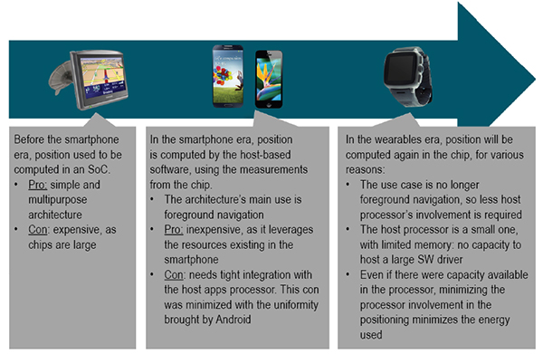
Satellite positioning embedded in devices over the last few years first saw on-chip positioning before the era of smartphones, where you had dedicated SoCs that supported the silicon used to compute the GNSS fix. These expensive chips had lots of processing power and lots of memory. Once GNSS started to be integrated into cellphones, these expensive chips did not make sense. GNSS processing could be offloaded from the expensive SoCs, and part of the GNSS processing was moved onto the smartphone application processor directly.
Since navigation is a foreground type of application, the host-based model was, and is still, a very good fit. But with advances in wearable devices, on-chip positioning will become the new architecture. This is because the host processor is small with very limited resources on wearables; and because energy must be minimized in wearables, reducing the processor involvement when computing GNSS fixes is critical.
Some vendors are taking old stand-alone chips designed for PNDs and repurposing them for wearable devices. This approach is not efficient, as these chips are large, expensive, and use a lot of power.
GNSS Accuracy
While the new fitness and background applications in wearables have forced changes in GNSS chips’ hardware and software architectures, GNSS accuracy cannot be compromised. Customers are used to the accuracy of GNSS; there’s no going backwards in performance in exchange for lower power consumption.
Figure 1. Software architecture for wearables.
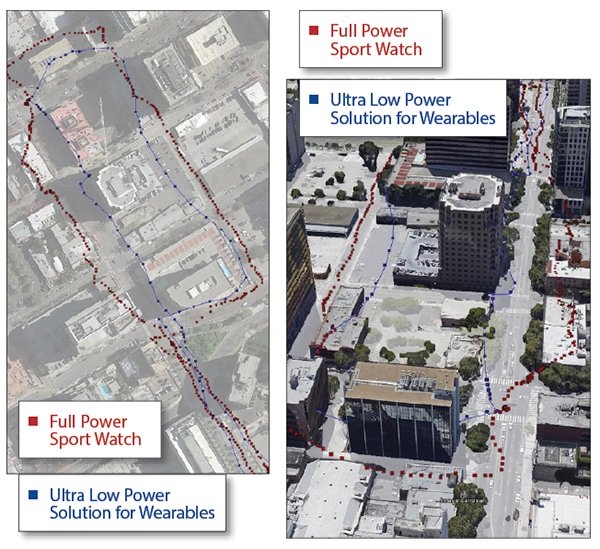
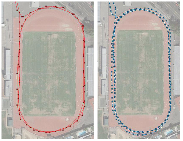
A series of tests shown here demonstrate how a new wearable, ultra-low-power GNSS chip produces a comparable GNSS track to existing devices using repurposed full-power sportwatch chips, while using only a fraction of the power.
Speed Accuracy. Not only does the ultra-low-power solution produce a comparable GNSS track, it actually outperforms existing solutions when it comes to speed and distance, thanks to close integration with sensors and dynamic power saving features (Figures 2 and 3).
Figure 2. Ultra-low-power versus full power.Figure 3. Full-power sportwatch, left, and ultra-low power chip, right, in more accuracy testing.
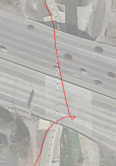
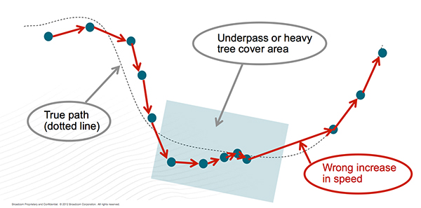
GNSS Reacquisition. GNSS-only wearable devices face a design challenge: to provide complete coverage and to avoid outliers. This is seen most clearly when the user runs or walks under an overpass (Figure 4). Familiar to urban joggers everywhere, the underpass allows the user to cross a busy road without needing to check for traffic, but requires the GNSS to reacquire the signals on the tunnel exit. See the GNSS track in Figure 5: when the device reacquires the signals, the position and speed accuracy suffers.
Figure 4. Position accuracy on reacquisition, emerging from overpass.Figure 5. GNSS speed accuracy on reacquisition.
Using the filtered GNSS and sensors, however (Figure 6), enables smooth tracking of speed and distance through the disturbance.
Figure 6. Sensors provide smooth speed estimate.
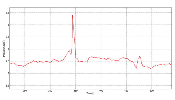
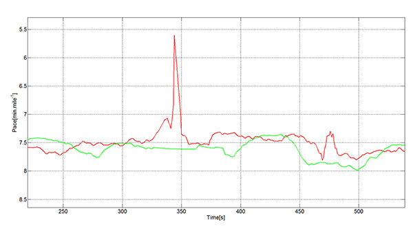
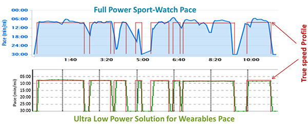
Urban Multipath. The pace analysis in Figure 7 shows a user instructed to run at a constant 8-minute/mile pace, stopping to cross the street where necessary. The red line on each plot shows the true pace profile. The commercial GNSS-only sportwatch on top shows frequent multipath artifacts, missing some of the stops and, worse for a runner, incorrectly showing erroneously high pace. The ultra-low-power chip captures all the stops and shows a constant running pace when not stopped.
Figure 7. Urban multipath tests.
It is well known in the community that regular sportwatches give unreliable speed and distance estimates in urban environments — where most organized running races are held! There’s nothing worse, as a runner, than to hear the distance beep from your watch going off earlier than expected: how demoralizing! The major benefit of this solution is that the speed estimate is much more reliable in the presence of multipath. At the same time, battery life can be extended because the GNSS is configured to use significantly less power.
fSpeed in existing solutions is computed in two different ways: indirectly from two consecutive, time-stamped GNSS position estimates, each derived from range measurements to the satellites, and directly from the Doppler frequency offset measurements to the satellites. Both range and frequency measurements are subject to significant error when the direct path to the satellite is blocked and a reflection is acquired.
The effects of multipath mean that the range error may in typical urban environments be hundreds of meters. The frequency error is also a function of the local geometry and is typically constrained by the magnitude of the user’s horizontal speed.
In either case, the GNSS device alone, in the presence of signal multipath, generates a velocity vector that fluctuates significantly, especially when there is a change in the satellites used or signal propagation path between the two consecutive positions. A variety of real-life cases generate this sudden fluctuation in velocity vector:
Running along a street in an urban canyon and turning a 90-degree corner.
Running along a pedestrian lane and taking a short road underpass.
Running under tree cover and suddenly arriving at an open area.
Running under an elevated highway and turning 90 degrees to a wide-open area.
In each case, the chips are using a certain set of satellites, and suddenly other, higher signal-strength satellites become available. A typical situation is for the position to be lagging the true position (while under tree cover, going through an underpass) and needing to catch up with the true position when arriving to the wide-open area. A jump in position is inevitable in that situation. This is not too bad for the GNSS track, but it will mean a noticeable peak in the speed values that is not accurate. Fitness applications save all of the computed speed values and generate a report for each workout. These reports are not accurate, especially the maximum speed values, for the reasons explained above.
Figure 8 describes a typical situation where the actual speed of the runner is approximately constant. GNSS fixes are computed regularly; however, the speed computed from subsequent GNSS fixes have sudden peaks that spoil the workout speed reports.
Figure 8. Sudden peaks spoil workout speed reports.
The new ultra-low-power solutions for wearables solve this problem by deriving speed and accumulated distance from the sensors running in the device. This avoids incorrect speed peaks, while still being responsive to true pace changes by the runner.
In running biomechanics, runners increase pace by increasing step cadence and/or increasing step length. Both methods depend on the runner’s training condition, technique, biomechanics, and so on. As a general rule, both step cadence and step length increase as the running speed increases from a jogging speed to a 1,500-meter race speed.
A runner may use one mechanism more than the other, depending on the moment or on the slope (uphill or downhill). In the case of male runners, the ratio of step length to height at a jogging speed is ~60 percent.The ratio of step length to height in a 1,500 meter race speed is ~100 percent. For female runners, the respective ratios are ~55 percent and ~90 percent.
The ultra-low-power chips take into account both mechanisms to derive the speed values. The sensor algorithms count the number of steps every time interval and translates the number of steps into distance multiplying by the step length. The reaction time of the GNSS chip to speed changes based on a higher cadence is immediate.
Speed changes due to longer steps are also measured by the ultra-low-power chips. The step length is constantly calibrated by the GNSS fixes when the estimated GNSS position error is low. The reaction time of the GNSS chip to speed changes based on longer steps has some delay, as it depends on the estimated error of the GNSS fixes.
Manufacturer
The ultra-low-power, high-accuracy, 40-nanometer single-die BCM4771 chip was designed by Broadcom Corporation. It is now being manufactured in production volumes and is focused on the wearables and IoT markets.It consumes five times less power than conventional GNSS chips (~10 mW) and needs 30 KBytes of memory in the MCU for the software driver. It features tight integration with the accelerometer and innovative GNSS tracking techniques for extremely accurate speed, accumulated distance, and GNSS tracking data.
Steve Malkos is an associate director of program management in the GPS Business Unit at Broadcom, responsible for defining GPS sensor hub and indoor positioning features. He has a B.S. in computer science from Purdue University, and currently holds eight patents,10 more pending, in location.
Manuel del Castillo is an associate director of marketing for Broadcom in the GNSS group. He has an MS in electronic engineering from the Polytechnic Universityand an MBA from the Instituto de Empresa, both in Madrid, Spain. He holds three patents in location with five more pending.
Steve Mole is a manager of software engineering for Broadcom in the GNSS group. He received his bachelor’s degree in physics and astrophysics from the University of Manchester.
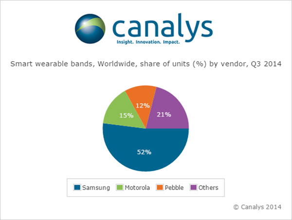
Nearly 5 million smart and basic wearable bands shipped in Q3 2014, with total unit shipments increasing 37% quarter on quarter as Android Wear made its mark for the first time, according to a report by independent analyst company Canalys.
Motorola Mobility’s Moto 360 was by far the most successful of the initial Android Wear devices, accounting for more than 15% of the smart band market according to Canalys estimates. Despite being supply-constrained, its appealing design helped it to easily out-ship other Android Wear products.
LG has responded to early interest in the Moto 360 by quickly adopting a circular display with the G Watch R.
Meanwhile, Samsung remained the overall smart band market leader, and the company has already begun to experiment with larger display sizes and cellular connectivity with the Gear S, its sixth smart band.
Though the platform is still young, Android Wear will be fundamental to the development of the market, as it is poised to be one of the two dominant wearable operating systems outside of China, alongside Apple’s Watch OS. But Google will need to redesign the Android Wear user interface before the platform can achieve its true potential.
‘The announcement of the Apple Watch late in the quarter has likely had an effect on sales of existing devices, as some consumers will choose to wait for Apple’s wearable,’ said Canalys Analyst Daniel Matte. ‘The smart band market was flat between Q2 and Q3, but with an installed base of over 1.8 billion Android smart phones, there is a huge potential market of Android users not considering an Apple Watch.”
Fitbit and Jawbone held onto their first and second place positions, respectively, in the basic band market for the quarter, and both have just announced new products. Garmin passed Nike to take third place in shipments, while Xiaomi and Huawei also overtook the one-time market leader and rounded out the top five. “Low-end basic bands providing simple activity tracking functionality are becoming increasingly commoditized, and will flood the market heading into the holidays, especially in China,” said Canalys Analyst Jingwen Wang. ‘To combat this, Fitbit, Jawbone and others have attempted to make basic bands smarter, adding various smart watch features and increasing the sophistication and integration of sensors.’
Google Fit, Microsoft Health and the Samsung Digital Health Platform have all recently been announced in response to Apple’s HealthKit. While the new Microsoft Band does not have strong hardware appeal, Microsoft’s cross-platform cloud services approach is a wise strategy, and the company is importantly staking its relevance early in a new market. There is tremendous opportunity for brand new services on wearable platforms, and not just in the area of health and fitness. Expect developers to eagerly embrace Apple’s WatchKit SDK, expected to be released in early 2015.
Wearable band shipment data is taken from Canalys’ Wearable Technology Analysis service, which provides quarterly market tracking, including country-level estimates. Canalys defines basic wearable bands as devices serving a specific set of purposes that act as accessories to smart devices, are designed to be worn on the body and not carried, and that cannot run third-party computing applications. Smart wearable bands are multi-purpose devices that serve as accessories to smart devices, are designed to be worn on the body and not carried, and are capable of running third-party computing applications. Bands are wearables designed to be wrapped around the body and do not include activity trackers in the form of clips.