The National States Geographic Information Council (NSGIC) Board of Directors has given its NSGIC Distinguished Service Award to Ivan DeLoatch, staff director of the Federal Geographic Data Committee (FGDC). The award recognizes an organization or individual who has demonstrated leadership in advancing the National Spatial Data Infrastructure (NSDI) by promoting NSGIC’s goal of efficient and effective government through prudent implementation of geospatial technologies. DeLoatch was cited for his work with the FGDC pertaining to the Geospatial Line of Business, one of the president’s E-Government initiatives.
The NSGIC Distinguished Service Award recognizes exemplary service that exceeds the normal expectation of duty and that has occurred over an extended period of time. Criteria for nominations for the Distinguished Service Award include actions that: benefit more than just the nominee’s own agency or organization; demonstrate measurable improvements in implementing the NSDI; provide leadership that benefits the nation; and work as a champion for all stakeholder groups.
Chris Cannon, (R) Representative for Utah’s Third District, and Geraldine Otremba, director of Congressional Relations at the Library of Congress, were the featured speakers during the event. The main topic of the breakfast was NSGIC’s “Imagery for the Nation” proposal, which is gaining increased interest among federal agencies and in Congress.
Trimble has expanded its portfolio of training products with a suite of modules for the engineering and construction industry. Facilitated through an Internet-based enterprise learning management system, the training modules will be available to distribution partners and customers.
Utilizing virtual reality technology, the interactive training modules provide simulations of how to use Trimble solutions. The simulation modules may be used as standalone training tools or as an integral part of a blended training program that encompasses e-learning and instructor-led training. Customers can access the simulation modules online and learn through hands-on training in the office or their home. An individual’s training history is recorded in the enterprise learning management system, providing a way of managing and tracking each person’s professional development.
“The introduction of the Trimble Knowledge Network is an important element in our overall strategy within the Engineering and Construction segment,” said Chris Gibson, general manager for Trimble’s Global Services Division of the Engineering and Construction segment. “Providing a highly innovative, cost-effective and comprehensive training program enables our customers and partners to refine their training activities to optimize productivity and maximize their return-on-investment through the use of Trimble solutions.”
To promote the relaunch of its online store, Leica Geosystems is offering a promotion for the Rugby 50 and 55 construction lasers. The redesigned B2C online store offers enhanced functionality, navigation features, and content to enable consumers to more easily and quickly find the tools and product information they need to make informed purchasing decisions. The enhanced customer-checkout functionality allows consumers to pay for products with the free payment service PayPal. Customers can also pay using Visa, Mastercard, American Express, or Discover cards. Users can purchase construction survey products directly from Leica Geosystems through the online store.
“The re-launch of Leica Geosystems’ B2C online store is all part of our commitment to continually improve our customers’ experience and to develop innovative ways to increase brand awareness of our construction survey product lines,” said Reynolds Boyd, Leica Geosystems’ product marketing manager and principal manager of the online store.
In line with this commitment is Leica Geosystems’ promotion of the latest additions to its construction laser family: the Leica Rugby 50 and Leica Rugby 55 interior and general construction rotating lasers. Customers have the opportunity to purchase these two construction lasers online at a reduced price. Until April 30, 2007, customers will receive $100 off Leica Rugby 50 packages and $125 off Leica Rugby 55 packages. These packages also include free second-day shipping.
At this moment, National Aeronautics and Space Administration (NASA) satellites outfitted with advanced sensors are gathering masses of data about phenomena that affect all of us: rainfall patterns, solar irradiation, and tropical deforestation, to name a few. Even great volumes of data, however, aren’t worth much unless they inform decision making. That’s why NASA’s Applied Sciences Program seeks to integrate Earth science research findings into decision support systems serving “applications of national priority,” and to document the resulting improvements in the performance of those systems.
To complete its ambitious decision support goals, the agency enlists some outside help. In February, the NASA Science Mission Directorate issued a request for proposals (RFP) entitled Research Opportunities in Space and Earth Sciences — 2007 (ROSES-2007). Academic, private, federal, public, and nonprofit organizations are invited to apply, and the program encourages applications from teams that comprise multiple organizational sectors and types of expertise.
In particular, said Lawrence Friedl of the Applied Sciences Program, the program is “hoping to build more private-sector involvement.” He explained that it’s a low-risk opportunity for companies with limited geospatial experience to learn “how other Earth observation data can be blended with datasets the private sector is already familiar with [such as high-resolution imagery]. It’s a way to get different parts of the community talking to each other . . . making connections, trying out unfamiliar technologies.” Ultimately, that cross-pollination effort will result in the development of new products and services.
NASA also teams with other federal agencies for benchmarking purposes, encouraging its partners to run their decision support processes without and with Earth observation data, quantifying benefits of the addition. In the case of homeland security, partner agencies include the Department of Defense (DoD), the National Oceanic and Atmospheric Administration (NOAA), and the Federal Emergency Management Agency. According to Friedl, limited staff forced a focus on the civil sector when the project began, but “over the past year, we have been increasing our interaction with the DoD side and intelligence communities.”
Homeland security is one of the 12 “applications of national priority” identified by NASA; the list also includes public health, disaster management, air quality, and energy management. NASA sensors contribute to homeland security by monitoring water supplies and checking for airborne toxins. Friedl gave the example of dispersion modeling, which enables the Department of Homeland Security to predict patterns of air movement in a particular city, as well as the downwind effects after a contamination incident.
Interested organizations should note that full proposals are due May 25, 2007, and project selection announcements are planned for September. Successful proposals will be awarded grants of approximately $240,000 to $320,000 per year for three years, beginning in 2008. This is the fourth such RFP in recent years, said Friedl, and the solicitation process is slated to continue on an annual basis.
East View Cartographic (EVC) has added 700,000 IKONOS satellite images to the online EVC Store. According to EVC, this is the first time that IKONOS imagery has been available in a fully functioning e-commerce environment complete with the support of experienced customer service representatives. Customers can browse available images geographically and place an order directly online, or get further personalized help from a representative.
EVC President and CEO Kent Lee described this addition as “A significant step forward in online imagery sales. Customers can buy IKONOS imagery online as easily and quickly as they can book a flight on Expedia.” Lee added, “This will allow GIS professionals to easily order an IKONOS scene informed by full scene metadata and a large preview pane of the scene without having to wait for a quote. It will also allow customers without GIS experience to quickly see what is available over their area of interest.” East View Cartographic is an authorized reseller of IKONOS imagery via an agreement with GeoEye.
This extensive catalog of satellite imagery could not be easily browsed and purchased online without EVC’s MetaLog Store. MetaLog Store is a robust platform with the ability to display large collections of data geographically, sort and filter using metadata, and allow online purchases. MetaLog Store powers EVC Store and is also available as a turnkey geospatial data management system.
This selection of IKONOS imagery with less than 25 percent cloud cover is the first of EVC’s imagery offerings to be added to EVC Store. New IKONOS data will be added on an ongoing basis, and SPOT imagery will be added to the website in the near future. Currently, SPOT imagery, QuickBird imagery, customized IKONOS scenes, and additional satellite imagery can all be ordered through EVC customer service representatives.
Why are the two GPS Transmitter frequencies (1575.42 and 1227.6 MHz) coherently selected integer multiples of 10.23 MHz master clock?
Question posted on CANSPACE on October 30, 2006, by Sivaraman Ranganathan.
The document defining the GPS signal, IS-GPS-200, states that “The carrier frequencies for the L1 and L2 signals shall be coherently derived from a common frequency source within the SV.” This makes the L1 and L2 multiples of the common frequency source 10.23MHz. (Section 3.3.1.1). Why is this? I believe this is done for simplicity of system design and operation. All components of the signal (code, carrier, and navigation data) are derived from the atomic frequency standards on board the satellite. If this were not done and separate frequency sources were used, then biases between the different components would occur, which would have to be calculated and removed.
IS-GPS-200 furthermore states in Section 3.3.1.8 that the C/A and P(Y) digital codes are as well derived from the same frequency standard. “All transmitted signals for a particular SV shall be coherently derived from the same on-board frequency standard; all digital signals shall be clocked in coincidence with the PRN transitions for the P-signal and occur at the P-signal transition speed. On the L1 channel the data transitions of the two modulating signals (i.e., that containing the P(Y)-code and that containing the C/A-code), L1 P(Y) and L1 C/A, shall be such that the average time difference between the transitions does not exceed 10 nanoseconds (two sigma)”.
Despite the coherence of the two carriers, it is understood there is a difference between the radiated L1 and L2 signals due in part to the different paths the signals take within the on-board electronics. This is called the differential group delay and an estimate of this difference is broadcast to users in the navigation message. The difference between L1 P(Y) and L2 P(Y) is designated Tgd (reference paragraph 20.3.3.3.3.2). The difference between L1 P(Y) and L2C is called the Inter-Signal Correction (ISC) (reference paragraph 30.3.3.3.1.1).
For further technical discussion of this topic, see the book Global Positioning System, Signals Measurements, and Performance by Pratap Misra and Per Enge (section 2.3.1).
Why are GLONASS satellites launched on Christmas Day? Question posted on CANSPACE on December 10, 2006, by Kerry Matthews
The latest triple-satellite GLONASS launch occurred on December 25th at 23:18 Moscow Time. This launch is the sixth GLONASS December launch in a row. In fact, all 9 launches since December 1995 have occurred in the last month of the year with the exception of the launch on October 13th, 2000 (see a list of GLONASS launches going back to 1990).
Including this month’s launch, three of the recent launches have occurred on December 25th and one originally scheduled for the 25th, occurred on the 26th. Why the preponderance of December launches and launches on Christmas Day in particular?
First of all, we should realize that for most people in the Russian Federation, there is nothing special about December 25th. Most Christians in Russia belong to the Russian Orthodox Church which celebrates Christmas according to the Julian calendar — on January 7th. And in modern Russia, January 7th is a state-wide holiday. So, GLONASS launches don’t occur around December 25th because it’s a special day on the Russian calendar. So why do they occur then?
I posed this question to Col. (ret.) Nikolai Shienok, the former chief of the Information Department of the Coordination and Scientific Information Center of the Russian Ministry of Defense. After conferring with officials from Roscosmos (the Russian space agency) responsible for the GLONASS program, Col. Shienok confirmed that it is only for financial or organizational reasons that there is a preponderance of launches in December. “It is the last month of the year and it is impossible to postpone a planned launch further” Col. Shienok said.
Nevertheless, there may be some operational calendar constraints on GLONASS satellite launches as there are for launches of other satellites. Satellite operators typically try to avoid launching satellites when the Sun-orbit-plane or beta angle for the intended orbit is unfavorable. The beta angle is the angle between the geocentric position vector to the Sun and the satellite’s orbital plane. This angle determines if and for how long a satellite will be in the Earth’s shadow during its orbit. For a given orbit (altitude, inclination, and initial right ascension of the ascending node), the beta angle will vary over the year. Operators try to avoid a launch date when the satellite would be in eclipse for a significant fraction of its orbit so that during the crucial satellite deployment and commissioning phase, the satellite’s solar panels receive as much sunlight as possible to keep the satellite’s batteries fully charged. The recent GLONASS launch put the satellites into Plane 2 which is actually in one of its eclipse seasons right now. However, the satellites will be out of eclipse by early January.
In this month’s column, Angelyn Moore, the IGS Central Bureau’s deputy director, overviews the organization’s service, history, and future, demonstrating that the IGS is a model of scientific collaboration of which not just the GNSS community but the whole world should be proud.—Richard Langley
Cingular Wireless has launched its first generally available, location-based service with TeleNav Inc’s GPS Navigator. Cingular business and government customers can get turn-by-turn voice and onscreen GPS directions, while driving or walking, on Cingular business devices including the HP iPAQ hw6920 and hw6500 Mobile Communicators, the Cingular 8125 Pocket PC, and the Palm Treo 650. The latter two devices require a Bluetooth GPS receiver. A GPS receiver is built into the Mobile Communicators. Features include:
full-color moving maps
a “Biz Finder” for locating nearby businesses such as cash machines, restaurants, hotels, and gas stations
a spot marker for locating a parked car
a fuel finder for finding low gas prices
pedestrian mode.
Pricing is $5.99 per month for up to 10 trips, or $9.99 per month for unlimited trips.
“Location-based services on wireless phones have disrupted the navigation market and created a more versatile solution for both businesses and consumers,” said Ken Hyers, principal mobile wireless analyst at ABI Research, of the launch of TeleNav GPS Navigator.
Philips Electronics, the Netherlands-based electronics giant that is Europe’s largest consumer electronics company, said in June 2006 that it would enter the personal navigation device (PND) market in the fall, to compete with Garmin, TomTom, Magellan, and other PND makers. But it abruptly pulled the plug on that effort in early December, stating that it was no longer interested. A spokesperson confided that the company had watched the market closely and decided it was too crowded.
This marks the second time Philips has retreated in this sector. Although its Carin system was an early dedicated in-vehicle nav system (circa 1990), and the company was an early investor in NavTeq, it later abandoned that market.
The booming European PND market, which analysts say could double to about 5 million units, has attracted Japanese consumer-electronics giants as well as many smaller Taiwanese manufacturers. Hardly a day goes by without a trumpeting of a new PND, often from a company heretofore unheard of in GPS and nav circles.
“It’s a very competitive market and it puts a lot of pressure on profit margins,” stated the Philips spokeperson. “We decided we need some focus, and navigation devices like these don’t fit within this focus.”
The company remains interested in GPS in general, but not for stand-alone products. “We don’t want to go further with GPS as a single device, but it’s an interesting technology to implement in other products,” she added. Mobile phones or digital music players remain as possible candidates for GPS capabilities.
GPS DATA maintains a 3D model that keeps a car correctly positioned while passengers hunt down werewolves.
Look out the window — is a werewolf hiding behind that tree?
Looking out the window while on a long car trip can be an adventure with a new GPS-based game being developed by The Interactive Institute in Stockholm, Sweden. The Backseat Playground uses GPS to turn passing sights like forests, buildings, and rivers into locations for in-game characters and events, reports New Scientist magazine. Backseat Playground consists of a GPS receiver, a handheld computer, and headphones — all connected to a laptop in the trunk of the car. A database of geographical information is used to match events in the game to suitable locations. Game characters and events are all generated dynamically during the car trip.
The game begins with a radio newsflash, relayed by the handheld computer, which places a passenger at the start of a murder mystery or a werewolf thriller. As the car travels along its route, the player receives further phone calls and messages from in-game characters.
Players interact mostly by listening; minimal graphics are involved, according to the designers. “It’s like a novel,” said John Bichard, who created Backseat Playground with colleagues Liselott Brunnberg and Oskar Juhlin. “We are trying to suggest spaces and places and events and have the user fill in the gaps to build a narrative.”
For now, a prototype now being evaluated only works over an area of 35 square kilometers in Stockholm. Initial feedback has been positive, and the team hopes to add voice recognition to the set-up. “Being able to talk directly to the characters would be great,” Bichard said.
We’ve always wondered what those werewolves had to say.
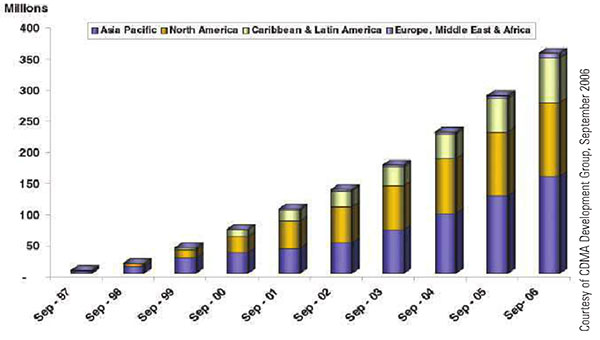
Figure 1. Global CDMA subscribers. CDMA cellular infrastructure uses GPS for synchronization and optimal performance. Location-based billing will require GNSS integrity.
By Vidal Ashkenazi
The use of satellite navigation in civil aviation and other safety-critical navigation applications drove the development of satellite-based augmentation systems and differential networks to track and augment GPS, providing the prerequisite levels of accuracy, integrity, coverage, and availability. Deployment and operation of Galileo — independent, compatible, and interoperable with GPS — will significantly add to the levels of accuracy, coverage, and system integrity.
Meanwhile, safety-critical transportation is no longer the only critical application considered for satellite navigation and positioning. New and developing financial-critical, business-critical, security-critical, legal-critical and government- policy-critical applications demand levels of coverage, integrity, and availability matching those of safety-critical transportation.
Consider road user charging (RUC) proposed by the British government to replace the current fixed annual road tax, which only depends on a vehicle’s size and pollution rating. RUC is based on taxing a car owner who drives only on country roads less than another driver who uses city centers and motorways, often during rush hours, contributing to traffic jams and pollution. It would be fairer if road taxing were based on when, where, and how you drive. The same principles also apply to car insurance and city-center congestion charging.
So far, all seems straightforward. But consider that with direct telematic links to individual bank accounts, these charges could be debited automatically, or invoiced and debited like monthly utility bills. Once money is involved, the operation becomes financially-critical. There is a need to demonstrate that such charges not only have high accuracy and integrity, but that they are “correct, beyond all reasonable doubt”.
As a scientist and an engineer, I have always used the terms “statistical levels of accuracy and integrity.” This is the first time in my scientific life that I have to use that statistically meaningless, unspeakable term “correct”, which implies 100 percent of certainty. GNSS, this is your challenge!
The same is true of the timing of stock exchange transactions and location-based billing via mobile phones. As the levels of accuracy, coverage and integrity of GNSS improve, so will the credibility of satellite positioning as a highly accurate, reliable tool for economically-critical applications.
It is difficult to distinguish between security-critical and legal-critical navigation and positioning applications. Both types will require very high levels of accuracy, coverage, and integrity, but most applications that start as security-critical may end up in a court of law and become legal-critical. Examples include tracking precious or hazardous cargos, tracking suspected individuals or criminals released on parole, the location of suspect mobile phone calls, and the positioning of fishing vessels inside territorial waters.
Lastly, many government/policy-critical navigation applications connected with police, fire and ambulance services, national security, and emergencies will require secure/encrypted GNSS signals. In the United States, where GPS is directed by the PNT Executive Committee, co-chaired by the DoD and the DoT, this should not present a problem, because the system is considered a fully dual military-civilian navigation tool. This is not the case in Europe, which has yet to define the framework for governance and use of the Public Regulated Service within EU member states, and the status of non-EU states proposing to collaborate on Galileo.
VIDAL ASHKENAZI is CEO of Nottingham Scientific Ltd., a UK-based company involved in Galileo since its earliest phase. He is a charter member of GPS World’s Editorial Advisory Board since 1990. This article is excerpted from his keynote address at IAIN World Congress 2006 held in Korea.