The Canadian Positioning, Navigation and Timing Office (PNTO) is warning stakeholders that Ligado has asked the Canadian government for access to spectrum that neighbors that of GNSS services. The request has long been a major issue in the United States because of the risk of radio frequency interference for GNSS users.
Image: da-kuk/E+/Getty Images
Innovation, Science and Economic Development’s (ISED) Spectrum Management and Telecommunications team announced on Aug. 19 a Notice of Application from Ligado Networks. The application seeks authority for providing terrestrial mobile services in the L-band (1526-1536 MHz in the MSS downlink, and 1627.5-1637.5 MHz and 1646.5-1656.5 MHz in the MSS uplink).
In its application, Ligado Canada is requesting that ISED adopt similar operational requirements and technical rules as those of the U.S. Federal Communications Commission. The rules are spelled out in 2020 FCC order 20-48, “FCC Ligado Amendment to License Modification Applications.” The operational requirements would allow Ligado Canada to provide ancillary terrestrial mobile services over specific portions of its licensed MSS spectrum.
Interested stakeholders can submit comments until Oct. 18 on ISED’s website. Respondents are requested to email their comments in Microsoft Word or Adobe PDF to [email protected].
CANSPACE Listserv is a service of Canadian Space Geodesy Forum and is administered by Dr. Richard Langley.
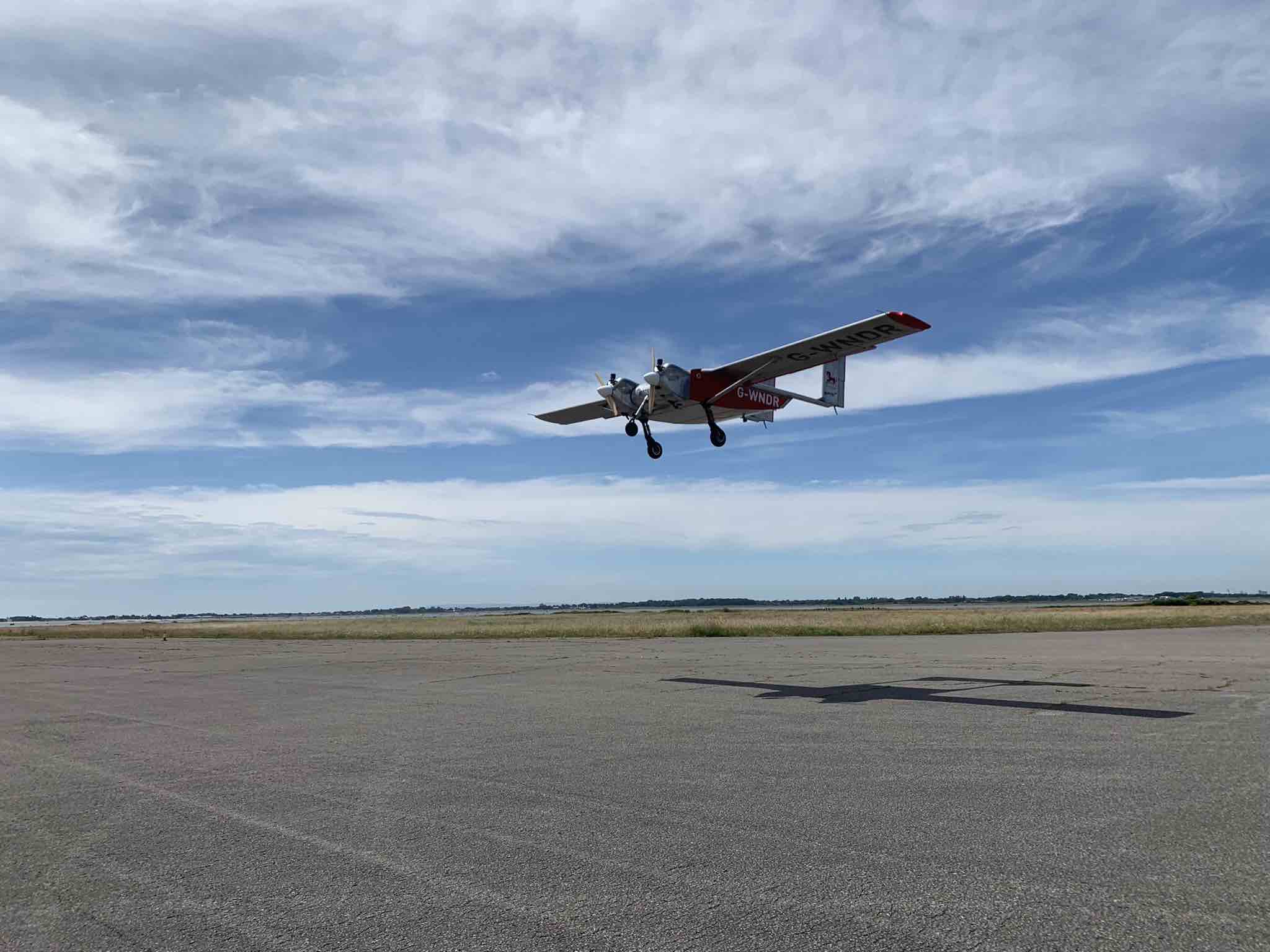
Helix Geospace will participate in the “Future flights challenge phase 3” project by Innovate UK involving drone swarms. The project aims to demonstrate how large unmanned systems can be used to solve environmental-protection concerns in GNSS-denied environments, functioning in swarms and utilizing a combination of digital twinning, computer vision and real-world flight testing.
The goal of the project is to prove that a single remote operator and local safety pilot can handle many unmanned devices and maintain continuous communication in GNSS-denied environments.
Commercially available antennas are susceptible to jamming and spoofing. DielectriX antennas from Helix Geospace are built into a sophisticated array system that can detect all jamming and spoofing events, pinpoint their precise source, and then eliminate their impact, maintaining the accuracy and resilience of GNSS positioning, navigation and timing in GNSS-denied environments.
Collaboration with NERC British Antarctic Survey and Lancashire fire and rescue will provide proof of exploitation and public engagement for the project. The Windracers aircraft will be equipped with British Antarctic Survey scientific research equipment and flown in the Antarctica region to gather novel research data, previously not achieved before at this scale.
The collaboration with Lancashire fire and rescue will help develop a solution for early fire detection and mitigation. The Windracers aircraft will be retrofitted with sensors and fire mitigation technology providing an airborne system that will patrol high-risk areas.
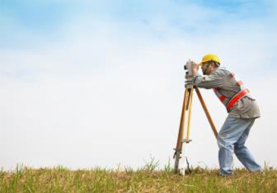
The average age of surveyors in the United States is nearly that of retirement. Can new technology attract a new generation to the profession?
“We do not fully understand the trend in the United States,” said Simon Peng, ComNav Technology, “but in China we find that modern survey technology — such as UAV/lidar mapping and total stations — make field work simple. New trends such as computer imaging, point clouds and building information models (BIM) attract young surveying engineers.”
Using the equipment in the field is becoming increasingly easier, said Bernhard Richter, Leica Geosystems. “Our goal is that operating the field equipment should not be more difficult than playing with your smartphone. That means that you don’t need the super expert in the field so much anymore.” However, he argued, “someone who studied surveying should now be more the data manager, have the expertise to put the data in geospatial relation, and know in which reference frame he is operating.”
For example, that person needs to know about orthometric and ellipsoidal heights, especially for engineering projects between countries that might have different height codes. “Anybody who has an interest to geolocate an object can capture the data and upload it to the cloud environment,” Richter said. “Then there are the data managers. Certainly, they need to know the physical limits of surveying technology, and they need to manage the complexity of modeling Earth. They need to become data managers to really put data to work.”
“The anticipated number of new professionals is not necessarily replacing all the surveyors who are expected to retire over the next 10 years,” said Boris Skopljak, Trimble. To tackle this challenge Trimble is using a two-pronged approach: attracting younger workers by raising awareness of surveying as a future career and modernization of the profession. For the first prong, Skopljak cited “phenomenal programs out there, such as Get Kids into Survey.” He pointed out that many Trimble employees are part of those education programs, “promoting inclusion of not just a younger generation, but also of women and minority groups that are heavily underrepresented in our industry today.”
For the second prong, “Digital data capture workflows present opportunities. A very common interview question we ask these days is ‘Do you play video games?’ Generally, those young professionals who are gamers thrive in the 3D environment. The technology aligns well with the interests of younger folks.”
Additionally, a growing number of educational institutions are evolving their curriculums to meet these needs, said Skopljak. Trimble is establishing Trimble Technology Labs in selected academic institutions around the world that are helping students access the latest technology and the best modern engineering practices. Boosting productivity also helps compensate for the declining number of surveyors, because it reduces the number of people needed to get the job done. “As the technology becomes easier to digest and operate and more focused on the workflows, it also becomes easier for companies to standardize it and attract talent,” Skopljak said.
One of the biggest threats to the survey profession, according to Huff, is that it “let bits and pieces of traditional surveys fall off to the wayside.” Geographic information systems (GIS) use the same positioning technology, he pointed out. “Fifty years ago, that was more of a function of the surveyor than it was necessarily the GIS profession. In many ways, while the surveyor is aging — the licensed cadastral surveyors certainly are aging — there is a new generation of folks coming through who are leveraging the new technology, such as drones and mobile mapping systems.”
This new generation, Huff argued, will achieve the same accuracies as the previous one partly because it’s getting easier to do so. “We definitely have more of a generation of digital users that can leverage the technology to do things where even my mentors performed many calculations by hand, on the fly, from plain tables in their logbooks with sine, cosine and tangent in them. Now, I think that technology and 3D immersive technology, which hinges on GPS location, attracts a younger crowd to certain facets of the profession.”
François Freulon, Septentrio, agreed that new technologies now available “can be easily adopted by new generations in the profession,” yet added that “quality surveying requires a good formation and experience in the field.” Therefore, he argued, “surveying education systems will need to adapt their programs and incorporate newer techniques such as new positioning modes and corrections.
Surely RTK remains as the main accuracy technique, but this could change quickly in the coming years as correction services bring better performance and regional coverage.”
Advances in GNSS technology constantly expand the range of projects that benefit from them.
ComNav Technology
A telecom company adopted its CORS station to build China’s national CORS service for public companies. It is increasingly used for field robotics, including the development of self-driving cars.
Leica Geosystems
Bernhard Richter, vice president of Geomatics, Leica Geosystems AG, pointed to one of the biggest infrastructure projects in Europe, which aims to connect London to Birmingham, Manchester and Leeds with a high-speed railway system, avoiding the need to fly between those cities. This will have great environmental benefits because high-speed trains are much more efficient than planes.
However, high-speed rail requires tremendous precision. “First comes the prep work, moving dirt,” said Richter. “Then you must install the railroad ties with tenths of a millimeter precision relative to each other to avoid side accelerations. For a surveyor, it really has everything in one project. You need to constantly work with civil engineers. You then try to build as much as possible with machine-control-guided systems to make the leveling as automated as possible.” The project will include building bridges over whole valleys and monitoring them, particularly during the construction phase, to ensure that they are not moving.
“Even the factory they are building is huge, so just to build the factory you need a lot of surveying,” Richter said. The project is generating 25,000 jobs at 300 construction sites, all of which must be managed on very tight schedules. In this context, the quality of the survey gear is critical. “On a construction site, the surveyor should be an invisible person,” Richter said. “When they come with the big machines and want to get stuff done, they don’t want a surveyor on the site. So, he has to work off hours, then remain on alert and trust that what comes out of an instrument is correct.” Leica Geosystems is one of the main suppliers for this project. “They chose us because of our focus on reliability, trust and quality.”
Trimble
Software is increasingly driving sales, pointed out Boris Skopljak, vice president, Surveying & Mapping Strategy and Product Marketing at Trimble Inc. As an example, he cited Trimble’s SX12 scanning total station, which uses Trimble Access software to leverage scanning, imaging and traditional total station capabilities in the field. “We have provided more inspection tools to enable people to decide whether something is meeting the tolerance.” The Trimble Connect cloud-based collaboration platform, coupled with the continuous field and office connectivity, has driven productivity increases and moved customers toward choosing the company’s solutions, he said.
As an example of Trimble solutions, Skopljak cited City Rail Link, New Zealand’s first underground rail network and the largest transportation infrastructure project ever undertaken there. “The Trimble R10 was integral to acquiring static observations above the work site, while the Trimble S9, DiNi and Trimble Business Center network adjustment were game changers for the survey control network,” he said. To expedite mine tunneling the surveyors used the SX12’s combined total station and scanning functionality with Trimble Access field software infield inspection tools. “Fewer customers are choosing solutions on a spec. It’s not about how many satellites you can track, for how many days, or how many points you can scan. They are choosing solutions based on the ecosystem and productivity.”
By Alex Damato, Acting Executive Director, GPS Innovation Alliance
Alex Damato
It can be easy to take GPS for granted as the average driver and smartphone user continues to enjoy convenience, entertainment and navigation from this technology, enhancing nearly every part of our daily lives. While we may not enjoy its benefits every day, one important use case keeps us and our environment safer: GPS has become a vital part of modern emergency response.
Many Americans across the nation are preparing for the impending hurricane season or the threat of other natural disasters, such as wildfires and earthquakes. GPS will play a critical role in recovery and response efforts. When natural disasters occur, accurate and actionable location information helps save lives and restore critical infrastructure as quickly as possible.
GPS has fundamentally improved access to information that can help the public prepare for these natural disasters, rather than waiting for them to strike. This information is more critical than ever. For example, California’s Oak fire spread to almost 20,000 acres and is part of a larger trend in California that has destroyed 14,700 buildings and killed 36 people over the past two years. Farther north, 530 wildfires in Alaska burned areas larger than the state of Connecticut in the state’s worst fire season in recent history.
In addition to helping the public face natural disasters, GPS helps firefighters plan their operations more efficiently and enables them to receive real-time information on the location of the wildfires they are fighting. With real-time mapping, planning and operations, fire chiefs can respond immediately to areas where wildfires are dangerously advancing.
In turn, GPS protects our first responders by preventing firefighters from getting caught in unpredictable fires they would have otherwise not known were heading their way.
Firefighters use IGNIS drones to help prevent wildfires from starting or safely contain them with backburns. IGNIS relies on GPS for tracking, safety and control, which in turn helps firefighters avoid the dangers associated with being near prescribed burns. Without GPS, resources to help firefighters would not be deployed as efficiently — wildfires could spread even more quickly as a result, causing even more damage to our homes and infrastructure.
Beyond wildfires, GPS technology is critical to emergency response and weather safety. GPS data allow emergency responders to better locate callers and reduce the incidence of misrouting to outside jurisdictions. Using GPS data, a caller can be located in close proximity to his or her actual location. By reducing rates of misrouting and accurately pinpointing emergency locations, GPS helps reduce response time by taking away the need to reroute calls and search for callers’ locations.
In a recent experiment, NASA-commissioned researchers used GPS signals to better predict a hurricane’s maximum wind speed, which could help federal agencies and forecasters better predict the danger of hurricanes and provide more actionable information to determine whether to issue evacuation orders.
The GPS Innovation Alliance (GPSIA) is proud to support the role of GPS as a critical enabling technology for public safety, disaster response and relief efforts. With GPS, precise real-time location information is at the fingertips of both consumers and first responders from pre-disaster planning efforts to post-disaster recovery. While GPS has already fundamentally improved modern emergency response systems, GPSIA will continue to advocate for the continued growth of these lifesaving GPS-enabled technologies and applications through rigorously developed technical rules, interference protections, and a predictable spectrum environment.
Many of us have grown accustomed to the ease of GPS-enabled technologies, from smartphone to fitness trackers. At GPSIA, we’re also particularly proud of the role GPS plays in the many other life-saving ways the technology is being used and are committed to continuing this critical work.
The Hawaiian Volcano Observatory (HVO) of the U.S. Geological Survey has been working to rebuild its geodesic monitoring network after lava consumed several GNSS stations in 2018.
The work began following the 2018 Kīlauea lower East Rift Zone eruption and summit collapse, with funding from the Additional Supplemental Appropriations for Disaster Relief Act of 2019 (H.R. 2157).
Teams are rebuilding and improving HVO’s geodetic monitoring network to better detect, assess and respond to volcanic hazards related to Hawaiian volcanoes. The main geodetic datasets used by HVO scientists to measure surface deformation (ground movements) are GNSS, tilt and satellite radar (InSAR) imagery.
HVO’s geodetic network includes more than 70 GNSS stations and 15 tiltmeters on the Island of Hawai’i that continuously record and transmit data. These instruments require routine maintenance, must be upgraded periodically due to age, and must be replaced if destroyed by volcanic activity such as in 2018.
Network upgrades include replacing out-of-date instruments and improving HVO’s network of near real-time monitoring instruments at critical areas on Kīlauea’s summit and rift zones to support early detection of magma movement and associated hazards.
Lava takes out stations
In 2018, lava flows destroyed three GNSS stations in the lower East Rift Zone. Another three GNSS stations were destroyed in the caldera collapses at Kīlauea’s summit.
HVO staff rapidly deployed new GNSS stations at nearby locations to allow for continued monitoring during the eruption. These rapidly deployed sites included GNSS smart antennas mounted on surveys tripods — a setup typically only used for temporary deployments of several days to weeks.
Many of these rapidly deployed sites were decommissioned and removed after 2018. However, 13 of them are still being used for critical monitoring and remain on temporary tripods. These sites will be upgraded and hardened using engineered fixed monuments and masts. New sites will also be installed to replace sites destroyed in 2018.
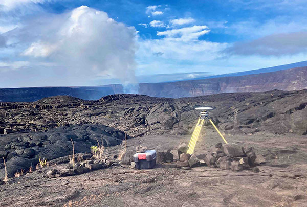
A temporary GNSS monitoring site in the Kīlauea caldera was part of the rapid response to the December 2020 Halema‘uma‘u eruption. The site will be upgraded into a continuously operating reference station with state-of-the-art instrumentation and a hardened antenna mast. (Photo: USGS/A.P Ellis)
Emergency monitoring ongoing
GNSS receivers acquired by supplemental funds already have supported emergency monitoring of active eruptions and other volcano-related activity. Data from these instruments help HVO detect volcanic activity and inform partners at Hawai’i Volcanoes National Park (HAVO), Hawai’i County Civil Defense (HCCD) and Hawai’i Emergency Management Agency (HI EMA).
For example, HVO rapidly deployed three new semi-continuous GNSS stations in response to the December 2020 Kīlauea eruption. These stations gave scientists a more complete view of magma returning to Kīlauea’s summit.
Similarly, HVO deployed rapid-response GNSS equipment at two pre-existing benchmarks during the Kīlauea south caldera intrusion event in August 2021, allowing scientists to track the migration of magma from the south caldera to farther south. New instruments give HVO a more detailed understanding of and ability to monitor Kīlauea’s volcanic processes.
HVO’s geodesy program plays a critical role in monitoring Hawaiian volcanoes. HVO’s updated geodetic network ensures that scientists can monitor changes in the shape of volcanoes, respond to eruptions, and understand magma storage and movement underground.
“Thanks to supplemental funding, HVO is in the best position ever to leverage our state-of-the-art geodetic network to gain insights into the active volcanoes in Hawai’i, assess their hazards, issue warnings, and advance scientific understanding to reduce the impacts of volcanic eruptions,” stated Volcano Watch, HVO’s weekly newsletter.
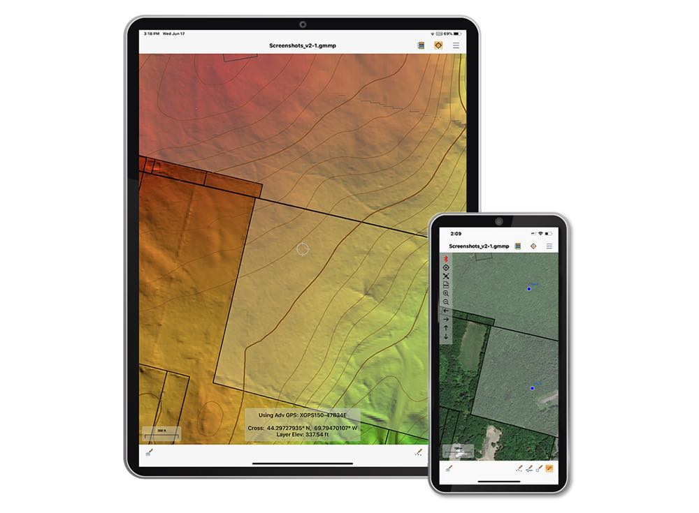
The Global Mapper Mobile Pro Module has always included the ability to connect to external GPS devices, but version 2.3 expands this to include support for any GNSS device that uses TCP/IP communication. Additionally, this mobile update provides Global Mapper analysis tools for volume calculation and viewshed for terrain data.
The mobile application of Global Mapper allows users to take the desktop functionality and existing data into the field for easy and accurate data collection and light processing. Since 2016, Global Mapper Mobile has been a user-friendly tool for capturing field data with portable iOS and Android mobile devices.
Version 2.3, available in both the free and Pro versions, adds many updates and improvements to the application, including the option to record and save voice memos to vector features and add multiple field-captured images to a feature. Autosave now prevents the loss of changes made to a map.
“Expanding user functionality in the field was the main focus of this release. Users of the base version of the application can utilize voice memos and the ability to save multiple photos to features for a more complete recording of field data,“ said Jeffrey Hatzel, Global Mapper Mobile product manager. “The Pro Module adds TCP/IP communication for external GNSS devices, expanding the list of compatible third-party devices. The addition of tools for volume calculation, viewshed analysis, and expanded projection support allows for even more workflows to be completed within the app.”
The new device will ship in the fourth quarter of this year and is available for pre-order
Juniper Systems is entering the 10-inch rugged tablet market with the launch of its Mesa Pro rugged tablet. The Mesa Pro features 11th Generation Intel Core processors, a Windows 11 operating system, device customization options, a large sunlight-readable display and “Juniper Rugged” company design.
“We are excited to be entering the 10-inch rugged tablet segment for the first time,” said Darren Hellstern, the Mesa Pro product manager at Juniper Systems. “Mesa Pro offers powerful processing, a rugged design meant for any environment, and is a versatile workstation that can be used in the office or the field.”
Standard Mesa Pro units come equipped with an 11th Gen Intel Core i5 processor and 16 GB of LPDDR4x RAM. Core i7 and Celeron versions of the device are also available.
Each Mesa Pro configuration offers powerful performance and allows users to select a level of computing performance that best fits their needs while having options that meet their budgets.
“It was important for us to offer performance tiers,” said Hellstern. “This is the first time we have offered various performance levels in one of our devices. The needs that our customers and users have varies greatly. From running CAD programs, viewing construction plans, mapping and mounted-vehicle solutions, we feel that we have an offering with Mesa Pro that fits the processing need of the user. We are also available to help users determine what level of performance they need.”
Mesa Pro joins the current Mesa family of 7-inch devices and helps Juniper Systems achieve its mission of providing powerful rugged computing and data-collection devices to mobile field workers everywhere. The Mesa 3 runs on either Windows or Android operating systems. The Mesa family started in 2010 with the launch of the Mesa Rugged Notepad.
“Mesa devices have served our customers for over a decade,” said Hellstern. “We are proud to add Mesa Pro to that list of incredible devices and offer more options to our customers and users around the world.”
Juniper Systems is now accepting pre-orders for the Mesa Pro.
Unicore has released its new generation of GNSS positioning product, the UM982. The UM982 is a high-precision dual-antenna real-time kinematic (RTK) positioning and heading module supporting all constellations and all frequencies.
The UM982 is suitable for use in UAV, precision agriculture and autonomous machine applications. The module is designed to meet the requirements of these markets, providing technological innovation. The module supports BDS B1I/B2I/B3I, GPS L1/L2/L5, GLONASS L1/L2, Galileo E1/E5a/E5b, QZSS L1/L2/L5 and SBAS in dual-antenna mode. It offers the following advantages.
Small size. The UM982 is highly integrated. With its size of 16.0 × 21.0 × 2.6 mm, it is a compact dual-antenna heading modules that reduces the design area of the customer’s board by 72% compared to previous modules.
Low power consumption. Low power consumption means less energy usage and a better application experience. Lowering the power consumption while keeping performance high is one of the key technical research directions of the GNSS positioning modules. The average power consumption of all versions of the UM982 module is less than 0.6 W, which is suitable for applications that require low power consumption, such as UAVs.
High integration. The UM982 was developed on the basis of NebulasIV, Unicore’s proprietary GNSS system on chip (SoC). NebulasIV integrates RF, baseband and high-precision algorithms on a single chip, with built-in functions providing powerful support for the UM982’s high performance.
High precision and high performance. The GNSS SoC is a key part of the navigation system, and the performance of the chip largely determines the performance of positioning modules. High-level performance indicators include raw observation accuracy, RTK positioning accuracy, PPP positioning accuracy, and time to first fix.
Robustness. Using the company’s dual-RTK technology, the UM982’s two antennas can independently participate in deriving an RTK solution and outputting the positioning results. This is convenient for customers conducting reliable verification in various application scenarios. By checking the RTK positioning results of both antennas, abnormal measurements in complex scenarios can be avoided.
High reliability. A built-in, advanced anti-jamming unit provides the UM982 with strong anti-jamming ability. The module detects jamming and can output the jamming strength. It also supports digital encryption to ensure the security of data transmission, and supports multi-frequency independent acquisition and tracking to ensure the reliability and accuracy of positioning results even in complex electromagnetic environments.
NextNav is partnering with CentralSquare Technologies, a public-sector technology company, to integrate z-axis vertical location capabilities into its computer-aided dispatch products and mobile suite of public safety software solutions.
CentralSquare works with more than 75% of public safety agencies nationwide, including first responders, law enforcement, fire departments, emergency medical services and local governments, equipping them with real-time data and situational awareness to decrease emergency response times.
By tapping into NextNav’s Pinnacle network, CentralSquare will be able to provide public safety agencies with critical vertical location data needed to precisely pinpoint the location of civilians in need of assistance during an emergency.
The integration of Pinnacle into CentralSquare’s product suite will provide users with enhanced knowledge of the most efficient routes within multi-story buildings to further reduce response times.
“Together with NextNav, we’re helping public safety agencies meet the needs of today’s dynamic world, particularly in densely populated urban cities,” said David Zolet, CEO of CentralSquare. “Adding z-axis enables our systems to not only derive location (x-axis and y-axis) but height (z-axis). This capability is the next logical step, decreasing emergency response times and ultimately helping to protect our communities and those that serve them.”
CentralSquare’s partnership with NextNav further establishes the company as the market leader in public safety dispatch solutions with the addition of floor-level accurate z-axis location. Once deployed, CentralSquare will deliver z-axis visualization in a 3D view, bringing visualization to their agencies and clients’ first responders. Field trials of the technology will begin towards the end of the summer, with an initial rollout anticipated in the fall.
The Pinnacle network delivers precise vertical location in 4,400 cities and towns, covering more than 90% of buildings greater than three stories in the United States, enabling better situational awareness for first responders. Earlier this year, a tier-one wireless carrier selected NextNav Pinnacle to bring z-axis capabilities to wireless 9-1-1 phone calls to enhance caller geolocation and emergency response outcomes.
“Expanding access to the life-saving z-axis capabilities our Pinnacle network provides is a top priority for us. Partnering with CentralSquare allows us to use this technology to positively impact the lives of the majority of public safety workers in the United States,” said Ganesh Pattabiraman, CEO and co-founder of NextNav. “CentralSquare is the largest provider for dispatch solutions signed to our ecosystem to date, bringing actionable floor-level insights to a vast number of individuals and scenarios. We’re growing our user base significantly, and along with it bolstering public safety and saving lives.”
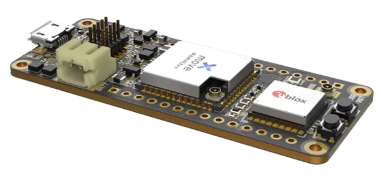
Telecommunication electronics company Move-X is offering a new LoRa/GNSS board. The Cicerone LoRa/GNSS board is a high-performance, low-power, Arduino MKR-compatible development board based on the u-blox MAX-M10S GNSS module and the MAMWLE LoRa module.
The Cicerone board delivers high-performance GNSS, long-range wireless connection, and high-performance MCU processing in a low-power solution for optimal battery life.
The board allows users to build tracking applications worldwide with meter-level accuracy and to communicate long-range, low-power data via LoRaWAN. The integrated Li-Po charging circuit enables the Cicerone board to manage battery charging through the USB port.
The Move-X Cicerone LoRa/GNSS board has a compact 63 x 25 mm form factor and is compatible with all Arduino MKR shield boards. These boards all share a common pinout to enable developers to easily add expansions with minimal software changes.
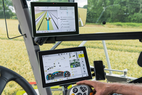
As part of a strategic alliance, Trimble and CLAAS have developed a next-generation system for CLAAS tractors, combines and forage harvesters.
The precision farming system includes the new CLAAS CEMIS 1200 “smart” display, GPS PILOT steering system and the SAT 900 GNSS receiver.
The CEMIS display uses Trimble’s new embedded modular software architecture for positioning, steering and ISOBUS technology for a seamless connection to control and monitor implements in the field. ISOBUS is an international communication protocol that sets the standard for agriculture electronics.
Trimble’s new architecture accelerates the development of a customized precision agriculture system by linking CLAAS’ machine interface and Trimble’s guidance capabilities into one common in-cab user experience.
“We understand the operators’ complexities of using separate displays with different user interfaces in the cab running the machine and performing precision farming tasks,” said Jim Chambers, vice president of Trimble Agriculture. “Working in tandem with CLAAS, we have jointly developed a next-generation precision farming system designed around one common user interface to provide CLAAS operators the best customer experience.”
“As an experienced, innovative and global provider of precision agriculture solutions, Trimble was our first choice as a technology partner,” said Carsten Hoff, managing director, CLAAS E-Systems. “Precision farming systems from Trimble have been field proven worldwide over the course of two decades. In addition, Trimble, supported by its subsidiary Müller-Elektronik, brings outstanding expertise in ISOBUS technology, which allows a display to control the machine and implement.”
The CEMIS 1200 display connects with the GPS PILOT system and SAT 900 GNSS receiver, based on the Trimble NAV-900 guidance controller, for positioning and steering capabilities. This solution provides sub-meter repeatable accuracy suitable for tillage, broad-acre seeding, spraying and harvest operations.
For even greater accuracy, users can subscribe to CLAAS-branded correction services from Trimble, called SATCOR, to achieve up to 2.5 centimeter pass-to-pass accuracy without a base station.
The precision farming system is already available for CLAAS TRION and is now expanding into LEXION, ARION, AXION and JAGUAR.