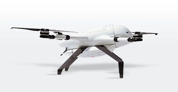
Beluga is a new generation of small unmanned aerial systems (sUAS), the result of three years of design and development. The Beluga sUAS is designed to perform a wide variety of tasks including medical transportation, precision farming, search and rescue, and last-mile delivery.
The system will include the uAvionix George G3, a CubePilot-based autopilot designed to DAL-C safety standards, and the truFYX EXT GPS which provides high-quality avionics at low size, weight and power consumption (SWaP) at a low cost. Beluga will soon include the ability to operate on skyLink C-band CNPC radios, fully integrated with George.
The George ecosystem includes a microLink radio, a truFYX GPS receiver and the George autopilot. (Photo: uAvionix)
This image shows the effect of increased elevation on surface area and obstacle avoidance. (Image: Advanced Navigation)
By Simon Harris, Advanced Navigation
Lidar-based surveying is increasing in demand across a range of industries. Recent market analyses indicate that lidar surveying is a multi-billion dollar industry that is expected to deliver sustained growth for years to come. As lidar technology matures and performance increases, its range of use is broadening into surveying more complex and difficult terrain or at speeds and in environments previously unsuited to such technology. Naturally, increasing diversity and performance brings about demands for greater reliability, speed and accuracy whilst remaining within physical and regulatory limitations.
Keeping pace with market demands in UAV and rail sector lidar surveying is increasingly challenging and requires an evolving synthesis between the acquisition and processing of lidar and GNSS-INS georeferencing data. Companies such as Cordel and its subsidiary Nextcore are taking advantage of the latest technologies to develop systems that are setting new benchmarks in these sectors.
Benefits of Altitude, Faster Lidar and Precision INS
UAV lidar surveying is capable of high-resolution surveys of complex terrain, vegetated areas and in light conditions that may be unsuitable to photogrammetry. These qualities make it a preferred option in many applications. However, it must remain cost-competitive with alternative solutions to become widely adopted by the surveying industry.
Typical UAV lidar surveying is performed at ~40m AGL. This altitude commonly presents collision risks with terrain and vegetation and imposes limits where the topography changes dramatically, such as voids that increase AGL beyond acceptable limits. Higher altitude surveying, therefore, offers obvious advantages, but also deeply challenges lidar sensors and the INS. Any mismatch in operational performance and accuracy between these inevitably degrades survey quality and severely limits use of the system.
Nextcore accepted the challenge and set about developing a viable solution that could maintain a point cloud density of 200-500 points per m2 from a target altitude of 70 m. This equates to generating lidar point cloud data at millions of points per second. Achieving this required a GNSS-INS that provided suitably precise georeferencing data. Because survey data is derived from a source that is in constant motion in 3D space, the capability of the GNSS-INS is paramount in producing a digital twin of value and is critical to mission success.
After testing and evaluating various INSs from different manufacturers, Nextcore coupled its lidar with Advanced Navigation’s MEMs-based Certus Evo INS, which provides near-FOG performance and has a drift rate of 0.2 degrees/hour. This combination yielded exceptional results that allowed them to vastly extend the altitude ceiling to 120m while retaining consistent, accurate survey data.
“Operation at this altitude not only reduces the risk of collisions with trees, it enables surveyors to cover larger areas, greatly improving the solution’s efficiency,” said Ashley Cox, founder and COO of Nextcore.
Higher altitudes tend to increase the lidar swath width. The typical swath width at ~50m altitude is ~120m, depending on actual altitude and the resulting angle of incidence of lidar toward the edges of the swath. At 120m, a reliable swath width of 180m was achieved. This is a 50% increase over previous, equating to approximately 33% fewer flight-lines to survey a given area — a notable boost for productivity and efficiency to surveyors.
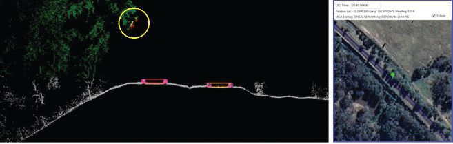
Example of rail track lidar showing encroaching vegetation, with associated map and location information. The yellow circle in the lidar data shows vegetation that is starting to intrude into the train’s path. (Images: Advanced Navigation)
Payload minimization also was a critical aspect in the search for an INS, as surveyors are always seeking longer flying time. This only can be achieved with a lighter technology stack payload. The team used an OEM version of the INS for a smaller form factor that could be integrated within a single ruggedized housing. This allows a design with greater strength, weather resistance and efficient payload setup.
“The industry is constantly seeking lighter payloads for longer flight times and to fit on smaller, safer UAVs,” Cox said. “Regulatory restrictions challenge the industry to meet certain specifications. The same is true for UAV lidar. We hit a ceiling. We need to be able to improve on that, although what we’re achieving now is a real game changer.”
The resulting survey material contains lidar point cloud data and the geo-referencing data from the INS. All data processing is performed post-flight to ensure the highest possible accuracy. PPK is used for correction of GNSS-INS position, roll, pitch and heading data. The processed INS data is then combined with the processed point cloud data to provide absolute position to the point cloud. This system realized consistent 30~40mm precision at 120m AGL. Nextcore has integrated the lidar and INS processing platforms to automate the synthesis of data sets, reducing the survey completion time. Depending on the survey’s size and complexity, this solution can process survey data into a 3D map within 30 minutes of mission completion.
Nextcore used a Certus Evo GNSS receiver, which internally uses the u-blox ZED-F9P chip. It logs GPS L1, L2, GLONASS L1, L2, Galileo GalE1, E5, and BeiDou B1, B2 frequencies at 8 Hz. It used the Kinematica correction service running a PPK filter.
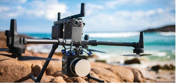
Lidar sensors have become light enough to mount on UAVs (Photo: Advanced Navigation)
Scanning Rail Corridors Super Fast
Aerial surveying is not the only environment to present challenges to lidar and INS.
Train-mounted lidar for automated track and rail corridor surveying is another burgeoning market. This application typically uses lidar and position data to detect and identify areas of the railway that require maintenance and, perhaps more importantly, preventive maintenance. Rail surveying presents unique demands, including operating at speeds of 160km/h (100mp/h) or more, maintaining position accuracy during GNSS outages and variable environmental conditions.
Land-based surveying provides flexibility for selecting an INS compared to aerial applications, as size and weight are usually irrelevant. Rail surveying also requires an INS that provides the necessary performance while tolerating vibration and erratic movement from junctions, points and signals, and be absolutely dependable in GNSS-denied situations. Cox’s team found that the greater accuracy and better drift stability of FOG INS over MEMS provided an ideal platform for generating reliable and accurate paths of train trajectory.
Cordel tested Advanced Navigation’s Boreas digital FOG INS as a potential solution. Testing was carried out using cars as a simulation, travelling complex routes in two directions then overlaying the lidar point clouds to check for discrepancies or unsynchronized areas. The results provided the confidence to put the Boreas into service.
Railways typically traverse deep cuttings, lengthy tunnels and other environments that disrupt GNSS. It is mission-critical that the INS can apply dead reckoning the instant GNSS is disrupted and maintain accurate position for the entirety of the outage. Reliable path and location data during GNSS disruptions is central to the viability of automated rail surveying. Blind spots or zones of unreliable route data cannot be tolerated by rail operators from safety, track availability and financial perspectives.
The Cordel AI lidar analysis system can be “tuned” to the required metrics and is capable of self-learning. The AI enables the system to pre-emptively identify and flag areas of concern before they become an actual problem or hazard. Examples include measuring track gauge and alignment, ballast distribution and coverage, and clearance between potential hazards to the train. The entire route is logged, creating a “Google map” of the railway that maintains a historical record of survey data each time the track is used.
Clients can then view a representation of the lidar data to get a clear understanding of any issues and how to respond before sending personnel or assets to a location. This enables intervention before safety is compromised or remedial works become large-scale and disruptive. As a result, rail service providers can maintain safer railways, deliver more reliable services, and minimize operating costs.
Spirent is one of only 226 organizations in the United Kingdom to be recognized with the Queen’s Award, which acknowledges the company’s excellence in international trade.
Spirent is headquartered in the UK, with its positioning business in Paignton, Devon, developing and manufacturing positioning, navigation and timing (PNT) test solutions. It also has a research and development facility in Daventry, Northamptonshire.
“As reliance on PNT technology continues to grow, our positioning technology business is the trusted partner of the world’s foremost PNT developers, delivering maximum performance without compromise through our dedicated test and validation solutions,” said Martin Foulger, general manager, Spirent Positioning. “We are honored to receive the prestigious Queen’s Award accolade, which is testament to the hard work of our employees in enabling us to achieve such tremendous success worldwide.”
Powered by its international trade, its exports outside of the UK represent a significant proportion of its business, serving a global customer base across five continents and more than 40 countries. Its technology has represented the global gold standard for commercial and government research and development facilities since the inception of GPS.
Its core business is the simulation of GNSS signals in laboratories for the development of applications used in advanced aircraft, chipsets, satellites, smartphones, cars, autonomous systems, marine vessels and defense systems, as well as the navigation systems themselves.
“Market leaders who are developing PNT applications have placed their trust in our test solutions for decades due to our unrivaled performance, realism and reliability,” said Foulger. “Furthermore, Spirent expertise is directly enabling and driving innovation in connected and autonomous vehicles and machine learning, as well as helping to make the world more sustainable through working closely with fields such as smart cities and precision agriculture.”
Now in its 56th year, the Queen’s Award are the most prestigious awards for businesses in the UK and a globally recognized royal seal of approval for companies. As a winner of the award, Spirent is permitted to display the esteemed Queen’s Awards Emblem for the next five years.
The following op-ed was released by U.S. representatives Don Bacon and Mikie Sherrill, co-chairs of the congressional Global Positioning System Caucus.
The US military needs a modernized GPS capability to maintain superiority
By Rep. Don Bacon and Rep. Mikie Sherrill
Don Bacon
In December 1993, the U.S. declared that the satellites comprising the Global Positioning System constellation had achieved initial operational capability, representing the culmination of a 20-year effort to develop and launch the first global navigation satellite system.
GPS, which began as a U.S. government project to provide positioning, navigation and timing information by broadcasting radio signals from satellites to the ground, stands alone in the revolutionary impact it has had on both our warfare abilities and our commercial industries. However, an aging constellation and unyielding international competition has put America’s GPS superiority at risk.
“We believe it is critical to our international interests that the U.S. reinvest in GPS modernization. We cannot afford to overlook the satellites.”
Mikie Sherrill
In the decades since achieving initial operational capability, GPS has become integrated into virtually every facet of the U.S. economy and is part of everything from our cellphones to our financial, agricultural, transportation and manufacturing sectors — and to every aspect of our national security.
Even as GPS has grown to become a fundamental part of our everyday life, the U.S. provides GPS signals for free to users worldwide. And yet, China, Russia, the European Union, India, and Japan have all developed regional or global satellite systems since GPS was launched.
Most recently, China’s completion of its BeiDou system comprised of over 30 satellites — part of its broad Belt and Road Initiative — risks endangering U.S. technological leadership. Beijing has made it clear that it will leverage BeiDou as part of an overall strategic effort to obtain greater influence internationally, heavily subsidize the adoption of BeiDou-equipped infrastructure for government and military use in countries throughout its region, and advantage BeiDou-compatible domestic products.
As the House co-chairs of the congressional GPS Caucus, we believe it is critical to our international interests that the U.S. reinvest in GPS modernization. We cannot afford to overlook the satellites — the oldest of which were launched in the late 1990s or early 2000s — that underpin civil and social infrastructure, including civil aviation, banking systems, financial markets, power grids, precision agriculture, and communications networks and applications. Even as manufacturers develop multi-constellation devices that can receive signals from both GPS and other global systems, it is more critical than ever that the U.S. accelerate its investment in next-generation GPS satellites.
To that end, the U.S. has begun modernizing the GPS constellation, with significant technological benefits for U.S. warfighters and civil users. New GPS satellites provide three times greater accuracy, and eight times improved resistance to inference and signal blocking known as jamming. However, the replacement of outdated GPS satellites in the constellation has not kept pace with our international competition and emerging global threats.
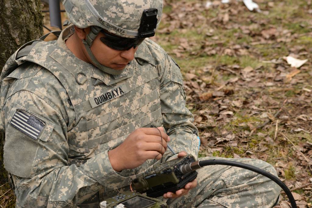
A U.S. paratrooper uses a Defense Advanced GPS Receiver during a live-fire exercise at Grafenwoehr, Germany. (Photo: Spc. Markus Rauchenberger/U.S. Army)
We believe that our efforts to invest in American technological leadership must include an increased launch rate of new GPS satellites with both crosslinks and on-orbit reprogrammable capabilities. Crosslinks enable greater accuracy, and on-orbit reprogrammability can counter jamming and spoofing by providing means to update signal and/or data streams and quickly counter emerging threats without the need to produce and launch new satellites.
A necessary and critical element of GPS modernization is also the development of a systematic road map for the use of our modernized GPS system by civil manufacturers and users across industries. Together, these steps will allow the United States to maintain its global leadership; enable U.S. firms to continue to offer innovative GPS-based products and services; and counter efforts by our international adversaries to give preference to their own technologies.
As the first and unrivaled provider of space-based services to the public, GPS currently provides $1 billion in economic impact from the U.S. civil GPS sector every day. As we move to a multi-constellation world, it is more critical than ever that the U.S. accelerates investment in our GPS enterprise to enable the next-generation benefits that a modernized constellation will bring to our warfighter, the U.S. economy and the free nations of the world.
Rep. Don Bacon, R-Neb., is a member of the House Armed Services Committee and a co-chair of the congressional Global Positioning System Caucus. He retired from the U.S. Air Force as a brigadier general.
Rep. Mikie Sherrill, D-N.J., serves on the House Armed Services Committee and is a co-chair of the congressional Global Positioning System Caucus. She served in the U.S. Navy for nearly a decade as a helicopter pilot and Russian policy officer.
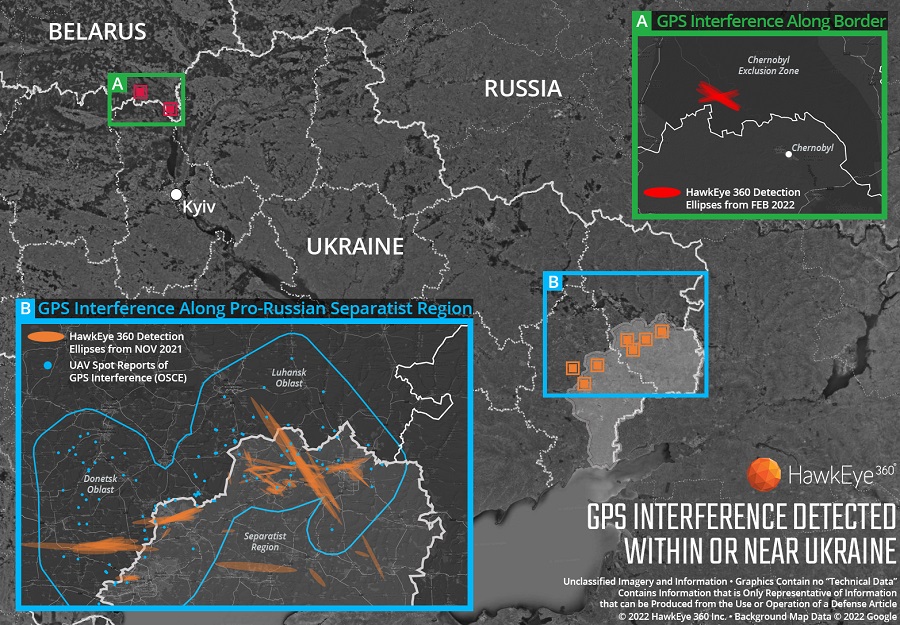
Technology from HawkEye 360 Inc. has detected and geolocated extensive GPS interference over Ukraine, starting months before the Russian invasion. HawkEye 360 uses satellites to monitor radio-frequency signals that might threaten military and civil navigation applications.
The capability was tested in 2021 in a variety of exercises and is available as part of HawkEye 360’s RFGeo signal product catalog.
When HawkEye 360 analysts examined Ukraine over the past five months, they discovered continued and increased GPS interference across the region. The data showed extensive GPS interference in November 2021 along the boundary of the pro-Russian separatist-controlled regions in Luhansk and Donetsk.
Open-source information confirmed unmanned aerial vehicles (UAVs) operating in the area were disrupted because of lost GPS connections.
In February 2022, HawkEye 360 detected GPS interference along the border between Ukraine and Belarus, shortly before the Russian invasion started. This February activity occurred north of Chernobyl within the Chernobyl Exclusion Zone, demonstrating the integration of electronic warfare tactics into Russian military operation to further degrade Ukraine’s ability for self-defense.
“GPS is a fundamental ‘global commons’ service that all modern economies depend upon. GPS signal interference has the potential to significantly disrupt air travel, logistics, finance, transportation, communication and many other basic services,” said John Serafini, CEO of HawkEye 360.
“Whether unintentional or deliberate, interference that prevents people, vehicles, ships, and planes from determining accurate locations can be devastating to government and commercial activities alike,” Serafini said. “Since HawkEye 360 can monitor hundreds of millions of square kilometers daily, we are able to notify clients when and where GPS interference occurs, so they can respond quickly to mitigate the impacts.”
Interference can be inadvertent by equipment operating too close to GPS frequency bands. However, deliberate interference has spiked across the globe due to the low cost, ease of deployment, and general availability of GPS jamming technology.
Military forces use GPS jammers to obscure and protect critical troops, facilities and equipment from attack and can be a leading indicator of future military activity. Drug cartels use GPS jammers to deter surveillance from overhead drones. Use of jammers is illegal in most developed nations.
HawkEye 360’s detection product offers a valuable capability to monitor for illicit and unintentional GPS interference that can significantly disrupt critical location services, representing the company’s global commitment to make the world a safer place, the company said.
Florida Power & Light to deploy 13 autonomous drones, with plans for hundreds more in coming years to monitor statewide power grid
UAV company Percepto will deploy autonomous drones to monitor Florida power substations and distribution grids across the state.
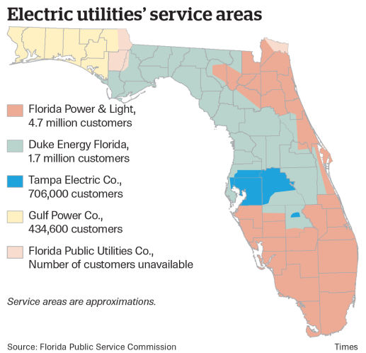
Florida Power & Light (FPL) will deploy drone-in-a-box technology statewide, which Percepto claims is the largest commercial autonomous drone project in the world.
FPL serves the northeast and southern half of Florida. (Image: Florida Public Service Commission)
Serving more than 11 million people in Florida, FPL uses Percepto’s Autonomous Inspection and Monitoring (AIM) solution powered by drones to perform routine infrastructure inspection and monitoring.
In the first phase of the project, 13 drones will take flight in the West Palm Beach area this year, with long-term plans to field hundreds of Percepto over the next five years.
The drone-in-a-box solution was the first to pass Level 5 hurricane testing at a wind speed of up to 155 mph, making it suitable for minimizing incident response times and power outages in Florida.
Percepto has served FPL since 2018, working closely to develop optimized drone monitoring solutions and build consensus and compliance with Federal Aviation Administration (FAA) regulations. The FAA issued a nationwide waiver for FPL to fly Percepto drones for surveillance and inspection purposes at sites owned and serviced by FPL.
As part of its ongoing work with the FAA, Percepto is a member of the Beyond Visual Line of Sight (BVLOS) Aviation Rulemaking Committee (ARC) that has provided its regulatory recommendations to fully incorporate highly automated BVLOS operations flights in the national airspace.
The drones in operation across the state will be coordinated on a single platform through Percepto’s AIM solution. With Percepto AIM, drones can be operated remotely to ensure that they work together in sync, providing maximum coverage at the sites they monitor.
Topcon Positioning Group has announced a new option for Caterpillar Next Gen excavator users to leverage Topcon 3D machine control functionality together with Cat Assist features. As a result of new compatibility of the Topcon 3D Excavator System with Caterpillar factory-installed NGH sensors, customers will experience simplified installation of the Topcon aftermarket system into Caterpillar’s existing 2D excavator systems, in coordination with Topcon and Caterpillar dealers.
“With increased pressure for productivity and accuracy, and the industry’s need for skilled operators, the solution is timely,” said Jamie Williamson, Topcon executive vice president. “The customer will have the benefit of Topcon 3D Excavator System and Caterpillar Assist features working together. Once the user is acquainted with the combined system, it will be easy to be a more productive operator.”
The Topcon system is designed to provide real-time, dynamic, on-screen bucket location and design views, resulting in the operator cutting grade faster and more accurately. The operator can create, cut and check designs directly from the cab. Together with Caterpillar boom and bucket automation, operators can deliver quality work all day long with less fatigue, according to Topcon.
“Seen & Heard” is a monthly feature of GPS World magazine, traveling the world to capture interesting and unusual news stories involving the GNSS/PNT industry.
A “BeiDou positioning system for subways” began construction March 20 on the Beijing subway capital airport express line. The project will cover a 30-kilometer-long section of the express line, including five stations. To provide positioning, the BeiDou Navigation Satellite System (BDS) will be combined with 5G for indoor positioning or in areas where the satellite signals are blocked. The system will improve the positioning accuracy in subways to less than 2 meters, making it available for vehicle dispatching, passenger transport organization and emergency response. In addition, it allows passengers to use their phones to navigate and position in complex environments in subway stations through three-dimensional navigation.
Image: ESA
THE SHAPE OF OCEAN WATER
The European Space Agency (ESA) investigated a technique to precisely measure sea-surface topography based on an idea submitted by the Institute for Space Studies of Catalonia (IEEC). The technique involves GNSS reflectometry — signals that have been reflected off of the sea surface at very low angles. The ESA-funded activity involved developing a GNSS receiver and setting up an experiment in the Balearic Islands to collect GNSS signals reflected off the sea surface. The team linked the coherence of the reflected signals to wave height and elevation angle of GNSS satellites. The team then processed the signals for optimized measurements of the shape of the sea surface, useful in applications such as ocean current forecasting, climate research, ship routing, cable laying and debris tracking.
Image: Japan network/Ohta and Ohzono, Tohoku University
CELLPHONE NETWORK DETECTS EARTHQUAKES
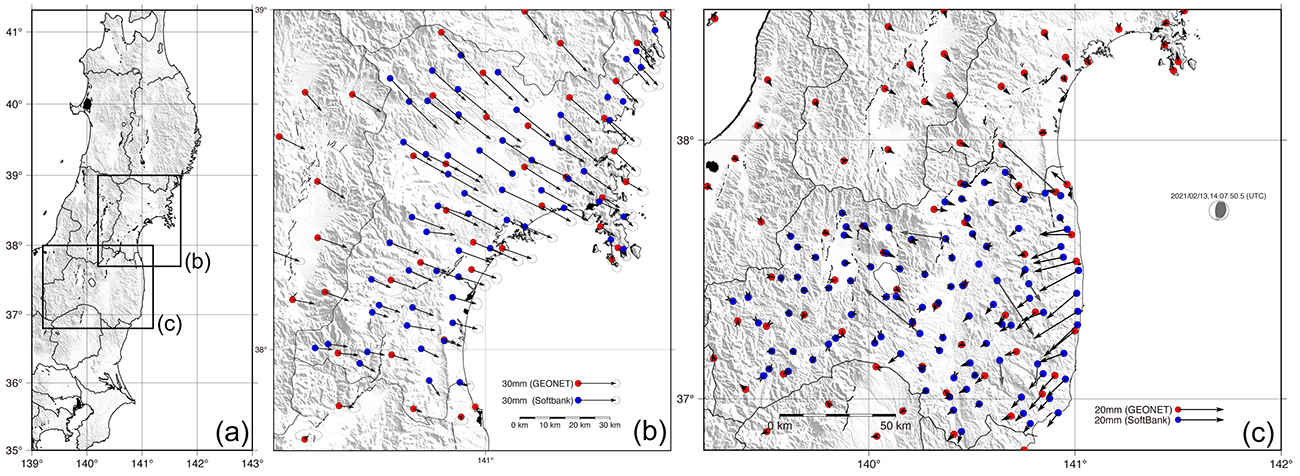
A paper published Feb. 9 in Earth, Planets and Space by Japanese Earth science researchers analyzed the potential of a dense network of GNSS receivers, installed at cellphone base stations, to monitor crustal deformation as an early warning indicator of seismic activity. Results showed that data from a cellphone network can rival the precision of data from a government-run GNSS receiver network, while providing more complete geographic coverage. Japanese cellphone carriers have constructed networks of GNSS receivers to improve locational information for such purposes as automated driving. The study examined the potential of a GNSS network built by SoftBank Corp. to play a role in monitoring crustal deformation.
Photo: Falklands Maritime Heritage Trust
ENDURANCE IN POLAR ICE
Researchers have discovered the remarkably well-preserved wreck of polar explorer Ernest Shackleton’s ship, Endurance, a century after it was swallowed up by Antarctic ice. A team of marine archaeologists, engineers and other scientists used an icebreaker ship and underwater drones to locate the wreck at the bottom of the Weddell Sea, near the Antarctica Peninsula. The ship is at a depth of 3,008 meters, 4 miles south of the position originally recorded by navigator Frank Worsley. The expedition team used two Saab autonomous underwater vehicles to explore in a pre-programmed search pattern. After the ship was located, technicians swapped out sonar equipment for a high-resolution camera and a laser-surveying device to make highly detailed scans of the site.
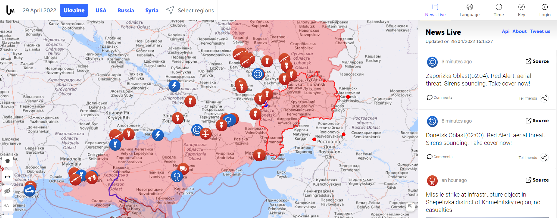
Amapping service provider birthed during the 2014 Ukraine conflict is tracking the current war through crowdsourced photos, Tweets, posts, news and other channels.
The Live Universal Awareness Mapwas founded by a team of software developers and journalists to inform the world about the Ukraine conflict. By viewer request, it quickly expanded to cover other regions, including Syria, Israel-Palestine and “Islamic State war” news. Today, it covers more than 30 regions and topics, offers translations in several languages, and can be used on mobile browsers via its own Android and iOS apps.
The independent global news and information site is dedicated to factual reporting of important topics such as conflicts, human rights issues, protests, terrorism, weapons deployment, health matters, natural disasters and weather-related stories from a vast array of sources.
Its map-centric approach to the organization of information allows viewers to quickly find relevant stories in geographies of their interest. Events are archived, and can be reviewed for analysis or historical trends. “Through our big-data analysis methods, we aim to help predict and prevent future conflicts, minimize the impact of disasters, and assist travelers around the world in making conscious decisions about their security throughout their journeys,” the service states.
Liveuamap uses proprietary software tools, such as artificial-intelligence web crawlers, to find newsworthy stories. These sources are then forwarded to a group of expert analysts for fact checking. In the final step, editors decide which facts and stories should be displayed on the map to minimize spam.
An improvement under development will enable viewers to create and manage their own maps.
DroneShield has begun releasing a software update across its counter-unmanned-aerial-system (C-UAS) devices, including portable, vehicle-based and fixed-site devices. The devices are used by the military, the intelligence community, U.S. Homeland Security, law enforcement, critical infrastructure and others.
The updates will be rolling out across DroneShield devices globally in the coming week, with heightened urgency given the widespread use of drones in Ukrainian and Middle Eastern conflicts. The technology upgrade is validated by deployments with the U.S. Air Force and Australian Army.
Enrolled devices receive quarterly firmware updates of the proprietary DroneShield RFAI artificial intelligence engine. Some of these updates are major enhancements, such as this 2Q22 release.
Major upgrades include:
Site Install Wizard. The new Spectrum Viewer mode, in which C-UAS detection devices scan the deployment area for optimal sensor placement
Machine Learning in the Loop. This option enhances the RFAI engine from the data received by the user.
Both features were added in response to end-user requirements.
New offerings will deliver accurate navigation to industrial applications even in areas where GPS is unavailable
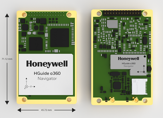
The HGuide o360 Navigator. (Photo: Honeywell)
Honeywell has expanded its HGuide industrial navigation portfolio with three new technologically advanced navigation systems — the HGuide o360 INS/GNSS navigator, HGuide n500 inertial navigator and the HGuide g080 GNSS receiver.
The new HGuide products are designed for a wide array of industrial and autonomous applications across air, land and sea vehicles and related equipment.
The HGuide o360 navigationsystem is a compact single-card, all-attitude inertial navigation system (INS) GNSS navigator that can deliver an accurate and robust position and attitude navigation service, even through GNSS-challenged or denied environments, to industrial and autonomous applications. It provides the features and compatibility needed for a simple integration.
“The HGuide o360 is an engineering marvel and a technological breakthrough. There are no similar competing products in the industry today that can achieve such a high-performance level at this price point and size,” said Matt Picchetti, vice president and general manager, Navigation & Sensors, Honeywell Aerospace. “The entire HGuide product line is suitable for a wide range of industries, including autonomous vehicles, marine and a host of industrial applications where accurate positioning and attitude information is required in real time.”
The HGuide o360 INS/GNSS navigator contains a powerful dual antenna, multi-frequency, multi-constellation, real-time kinematic (RTK) GNSS receiver, Honeywell’s i300 inertial measurement unit (IMU) technology, and a high-grade calibrated magnetometer.
The HGuide o360 is designed for platforms that require high-performance navigation data in an ultra-low size, weight and power (SWAP) package.
The HGuide n500 inertial navigator is a navigation-grade bring-your-own-GNSS all-attitude navigator that supports continuous position and attitude navigation even during prolonged GNSS outages. The HGuide n500 is built on Honeywell’s HG4930 IMU plus the Honeywell HGuide Sensor Fusion software.
The HGuide g080 GNSS receiver is a dual-antenna, triple-radio frequency, all-constellation GNSS receiver that delivers heading and positioning down to sub-centimeter levels even in GNSS-challenged environments. It includes an onboard IMU to allow tracking during short GNSS outages and enable smooth and fast reacquisition. The product is available with or without RTK functionality.
Inertial navigation systems are highly critical in navigation and comprise an IMU, a GNSS receiver and sensor fusion software. These components work together to calculate position, orientation and velocity to deliver critical navigation information in GNSS-denied areas such as urban canyons, bridges, tunnels, mountains, parking garages and dense forests.
Russia’s brutal aggression on Ukraine changed the world in a few days. Devastation and displacement in Europe already are on a scale unseen since World War II, and the risk of a catastrophe greater by orders of magnitude has not been as high since the Cuban Missile Crisis of 1962, the year I was born. Given the long production timeline of a monthly magazine, I will not venture a guess as to what the headlines will be on the day you read this.
The Russian assault has sharply raised concerns about GNSS vulnerabilities. In a March 17 bulletin, the European Union Aviation Safety Agency (EASA) warned of a GNSS outage leading to the degradation of navigation and surveillance. Reports analyzed by EASA indicate that since Feb. 24, GNSS spoofing and jamming has intensified in the Baltic Sea, neighboring states, Eastern Finland, the Black Sea and the Eastern Mediterranean. “The effects of GNSS jamming and/or possible spoofing,” the bulletin stated, “were observed by aircraft in various phases of their flights, in certain cases leading to re-routing or even to change the destination due to the inability to perform a safe landing procedure.”
Russia already has aided in the proliferation of handheld GPS jammers, the deployment of road-mobile jammers, and even development and testing of space-based jammers. Now, it could turn its substantial cyberspace hacking capability against the ground-control segments of GPS and Galileo.
When Russia tested an anti-satellite weapon on Nov. 15, 2021, the Kremlin claimed on state television that this capability “means that if NATO crosses our red line, it risks losing all 32 of its GPS satellites at once.” This threat was particularly dangerous because GPS satellites carry, as a secondary payload, the U.S. nuclear detonation detection system.
At a panel discussion about resilient GPS that I moderated at the International Wireless Communications Expo in Las Vegas on March 24, Diana Furchtgott-Roth, an adjunct professor at George Washington University and former deputy assistant secretary for Research and Technology at the U.S. Department of Transportation (DOT), titled her presentation “Russia Proves America Needs Backup GPS.” She cited the National Defense Authorization Act of 2017, the National Defense Authorization Act of 2018, and the National Timing Resilience and Security Act of 2018, which instructed DOT to provide a complement and backup for civilian GPS. The legislation required the Secretary of Transportation to put in place a backup system for GPS by the end of 2020, subject to congressional appropriations. However, she pointed out, these funds have not yet materialized.
Multiple technologies can and should be used to complement GPS. Several of them are mature and commercially available, including signals from low Earth orbit satellites and terrestrial broadcast stations.
Meanwhile, the United States should accelerate the launch schedule for GPS III satellites already produced. They provide better accuracy, anti-jamming capabilities, and opportunities for civilian connectivity that could offer critical assistance to its European allies.