Blog

  • EUSPA recounts accomplishments at first anniversary

    EUSPA recounts accomplishments at first anniversary

    The European Union Agency for the Space Programme (EUSPA) is celebrating its one-year anniversary by sharing its achievements, including through a new video and an interactive quiz.

    EUSPA’s mission is to link space to user needs. Over the past year, EUSPA has increased access to EU space data and services around the world, launched new Galileo satellites, and put in place additional satellite navigation services.


    Think you know the EU Space Programme? Prove it by taking EUSPA’s interactive quiz.


    EUSPA operates Europe’s satellite navigation systems Galileo and EGNOS. It is also the gatekeeper to a secure EU Space Programme, providing end users with the confidence of knowing that the space-derived data they depend on is safe and secure.

    The agency plays a central role in the market uptake of the data and services offered by the EU Space Programme components. EUSPA also manages the development of GOVSATCOM hubs, which will provide secure, cost-efficient communication capabilities to security and safety-critical governmental missions, operations and infrastructure.


    On 17 May, EUSPA is hosting a GNSS Raw Measurements Task Force meeting, a chance to learn the latest on using GNSS raw measurements with Android devices.


    First-year accomplishments include:

    “I am more than proud of what EUSPA has achieved in a year. I am also proud to be at the helm of an organization staffed with dedicated professionals, with a service-oriented mindset who work to make EU Space accessible to citizens,’’ said Rodrigo da Costa, EUSPA executive director. “EUSPA remains committed to helping the union and its citizens maximize the socio-economic benefits of space.”
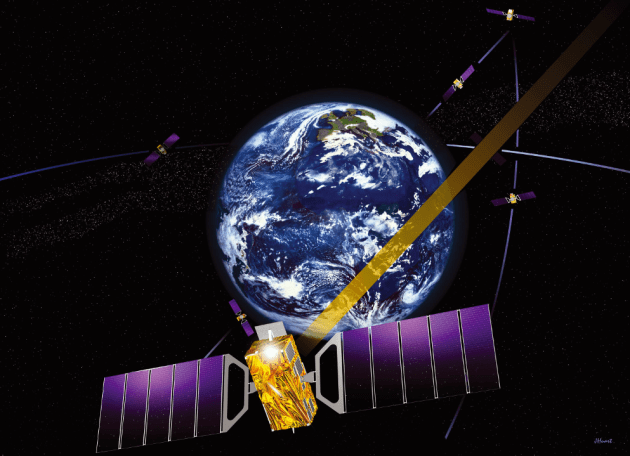

    Image: EUSPA
    Image: EUSPA
  • FAA approves airworthiness criteria for Wingcopter delivery drone

    FAA approves airworthiness criteria for Wingcopter delivery drone

    Photo: Wingcopter
    Photo: Wingcopter

    The U.S. Federal Aviation Administration (FAA) has issued the Special Class Airworthiness Criteria for the Wingcopter 198 U.S. unmanned aircraft. This approval marks a critical milestone in the certification process of Wingcopter’s flagship delivery drone in the United States.

    Wingcopter is a German manufacturer of  fixed-wing unmanned aircraft systems (UAS) and provider of drone delivery services, focused on optimizing medical supply chains, as well as last-mile logistics of packages, tools, spare parts, food, and groceries. 

    With the Airworthiness Criteria, the FAA defines technological requirements under title 14, Code of Federal Regulations (14 CFR), § 21.17(b) that must be met to have an aircraft type-certified for regular commercial operations in the United States.

    The Wingcopter 198 is an electric vertical-takeoff-and-landing (eVTOL) drone engineered to meet stringent safety standards. In its development, Wingcopter was able to leverage the operational experience of more than five years with the company’s first delivery drone type in various geographical settings, from the Arctics to the Middle Eastern desert and from remote islands in the South Pacific to San Diego Bay in the United States.

    Once type-certified, Wingcopter will be able to fly conventional routes through airspace and over populated areas, ultimately providing the basis for scaling commercial drone delivery operations across the United States that will help save and improve lives, the company said.

    The certification is expected to have a positive impact on Wingcopter’s further certification efforts such as with the National Civil Aviation Agency (ANAC) in Brazil or the Japan Civil Aviation Bureau (JCAB).

    Since applying for the Special Class Type Certificate in March 2020, Wingcopter has collaborated closely with the FAA. The issuance allows Wingcopter to focus its development efforts even more on what the FAA deems necessary for this particular aircraft to receive certification quickly and efficiently.

    “We are proud to be among the first delivery drone companies worldwide to ever get their Airworthiness Criteria approved by the FAA,” said Tom Plümmer, co-founder and CEO of Wingcopter. “This is a very important milestone for us, not only in our Type Certification Process in the United States, but also for our international expansion efforts and for achieving our vision of building logistical highways in the sky. I would like to thank my team as well as the FAA for all the effort and great collaboration to reach this milestone.”

  • Advanced Navigation acquires Vai Photonics for precision navigation

    Advanced Navigation acquires Vai Photonics for precision navigation

    Vai Photonics was founded in Canberra in 2021 by physicists Lyle Roberts (left) and James Spollard to commercialize their research at Australian National University. ANU Vice Chancellor Brian Schmidt is at right. (Photo: Vai Photonics)
    Vai Photonics was founded in Canberra in 2021 by physicists Lyle Roberts (left) and James Spollard to commercialize their research at Australian National University. ANU Vice Chancellor Brian Schmidt is at right. (Photo: Vai Photonics)

    Advanced Navigation has acquired Vai Photonics, a spin-out from Australian National University (ANU) developing patented photonic sensors for precision navigation.

    Vai Photonics’ vision, to provide technology to drive the autonomy revolution, is similar to Advanced Navigation’s. It will join Advanced Navigation in commercializing its research into autonomous and robotic applications across land, air, sea and space.

    “The technology Vai Photonics is developing will be of huge importance to the emerging autonomy revolution,” said Xavier Orr, CEO and co-founder of Advanced Navigation. “The synergies, shared vision and collaborative potential we see between Vai Photonics and Advanced Navigation will enable us to be at the absolute forefront of robotic- and autonomy-driven technologies. Photonic technology will be critical to the overall success, safety and reliability of these new systems.”

    James Spollard, CTO and co-founder of Vai Photonics, explained the technology. “Precision navigation when GPS is unavailable or unreliable is a major challenge in the development of autonomous systems. Our emerging photonic-sensing technology will enable positioning and navigation that is orders of magnitude more stable and precise than existing solutions in these environments. By combining laser interferometry and electro-optics with advanced signal-processing algorithms and real-time software, we can measure how fast a vehicle is moving in three dimensions. As a result, we can accurately measure how the vehicle is moving through the environment, and from this infer where the vehicle is located with great precision.”

    The technology, in development for more than 15 years at ANU, will solve complex autonomy challenges across aerospace, automotive, weather and space exploration, as well as railways and logistics.

    Aircraft with an electric vertical-takeoff-and-landing system such as flying taxis will greatly benefit from this technology, according to Advanced Navigation. Landing and takeoff are often considered the most dangerous and expensive part of a flight route. Vai Photonics sensors will provide safe and reliable autonomous takeoff and landings under all conditions.

    Space travel and exploration is fraught with risks, vast complexity and enormous cost. This technology will bring massive benefits to space missions, helping to cement Advanced Navigation as the gold-standard for space-qualified navigation systems for space exploration.

    “The work that underpins Vai Photonics’ advanced autonomous navigation systems stems from the search for elusive gravitational waves — ripples in space and time caused by massive cosmic events like black holes colliding,” said Brian Schmidt, vice-chancellor of ANU. “The team have built on a decade of research and development across advanced and ultra-precise laser measurements, digital signals and quantum optics to build their innovative navigation technology.”


  • DJI introduces Mini 3 Pro camera drone

    DJI introduces Mini 3 Pro camera drone

    The DJI Mini 3 Pro is the high-end product of the DJI Mini series

    DJI Mini 3 Pro. (Photo: DJI)
    DJI Mini 3 Pro. (Photo: DJI)

    DJI has introduced the DJI Mini 3 Pro, its most powerful lightweight and portable camera drone. Weighing less than 249 grams — making it policy-friendly in many regions and countries — it delivers advanced features such as 4K/60 fps video, ActiveTrack, tri-directional obstacle sensing, and 90° gimbal rotation to shoot high-quality vertical imaging for social media. Its flight time extends past 30 minutes.

    According to the regulations of many countries and regions, drones under 250 grams have been placed in the safest drone category. At under 249 grams, Mini 3 Pro’s weight, safety and performance is a new resource for content creators and new pilots.

    Like its predecessors — Mavic Mini, Mini 2 and Mini SE — the Mini 3 can be folded for packing. Built-in features include enhanced flight performance, camera system, battery life and intelligent features previously available only in the Air and Mavic series.

    New structural design. The arms and propellers have been adjusted for more aerodynamic flight, increasing flight time. Forward and backward dual-vision sensors broaden the sensing range for safer flight. A complete gimbal redesign unlocks more camera angles, enabling movements such as tilt-up shots and vertical shooting.

    The Mini 3 Pro features tri-directional obstacle sensing, consisting of forward, backward and downward visual sensors. The forward and downward sensors have a wider field of view, providing seamless coverage for better route planning and environmental awareness. These sensors also enable Advanced Pilot Assistance System (APAS) 4.0, which automatically detects and finds a safer path around obstacles during flight.

    In addition, these sensors enable the FocusTrack suite, which allows users to select a subject that the drone automatically keeps within the center of the frame during flight while automatically planning a safe flight route.

  • Tallysman adds eXtended Filtering (XF) to dual-band GNSS antennas

    Tallysman adds eXtended Filtering (XF) to dual-band GNSS antennas

    Photo: Tallysman
    Photo: Tallysman

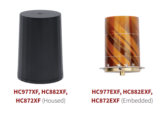
    Tallysman Wireless has added eXtended Filtering (XF) to the housed and embedded lightweight HC977XF (triple-band + L-band), HC882XF (dual band + L-band) and HC872XF (dual-band (GPS and GLONASS) + L-band) precision helical GNSS antennas.

    Tallysman has designed the XF feature to mitigate interference from all near-band signals and ensure that the antenna provides the purest GNSS signals.

    The radio-frequency spectrum has become congested worldwide as many new LTE bands have been activated, and their signals or harmonic frequencies can affect GNSS antennas and receivers. In North America, the planned Ligado service, which will broadcast in the frequency range of 1526–1536 MHz, can affect GNSS antennas that receive space-based L-band correction service signals (1539–1559 MHz). New LTE signals in Europe (band 32, 1452–1496 MHz) and Japan (bands 11 and 21, 1476–1511 MHz) have also affected GNSS signals.

    Tallysman’s housed helical antennas weigh ~42 g and are enclosed in a robust military-grade IP67 plastic enclosure. The antenna base has an integrated SMA connector, a waterproofing O-ring, and three screw holes to enable secure attachment. Tallysman’s embedded helical antennas weigh ~8 g and are easily mounted with an optional embedded helical mounting ring, which traps the outer edge of the antenna circuit board to the host circuit board or any flat surface.
    An MCX connector is installed in the base of the antenna.

    Tallysman helical antennas are suitable for a variety of applications, including lightweight unmanned autonomous vehicle navigation (land, sea and air), land survey devices, automotive positioning, timing and other precise-positioning applications.

  • Leica Pegasus TRK mobile mapper guided by AI

    Leica Pegasus TRK mobile mapper guided by AI

    Photo: Leica
    Photo: Leica

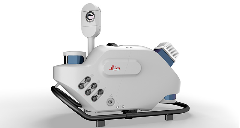
    Leica Geosystems, part of Hexagon, has introduced Leica Pegasus TRK, a reality-capture mobile-mapping system that features artificial intelligence (AI), autonomous workflows and intuitive interfaces.

    The Pegasus TRK features an AI-enhanced camera and automatic camera calibration. To comply with privacy regulations, its AI can identify and blur identifiers, such as people and vehicles, in real time.

    Features include advanced dynamic laser scanning and an expandable imagery system for recording, measuring and visualizing environments. It also increases productivity with automated, intelligent workflows.

    Light enough to be operated by one person, the Pegasus TRK is user-friendly, able to be used by professionals new to the technology. Its reliable, high-quality deliverables serve the needs of technical experts in various industries, including surveying, transportation and utilities.

    The Pegasus TRK solution enables long-range mobile mapping for applications in asset management; road construction; rail and critical infrastructure; oil, gas and electricity industries and more. The system also is suitable for creating high-definition base maps for autonomous vehicles.

    The Pegasus TRK connects with the new powerful Leica Pegasus FIELD software for fully autonomous and secure data collection and route planning in the field. It also connects with Leica Cyclone Pegasus OFFICE for seamless input into post-processing and publishing workflows.

    “The Pegasus TRK solution is the most efficient mobile mapping product we’ve tried so far,” said Raymon Somford, CEO and owner of Rise3D. “It is lightweight and easy to use, guiding our team through the process of data collection. Its sensors that trigger automatically avoid missing details. We can achieve quality images regardless of the conditions, making mobile mapping almost effortless.”

    “The Pegasus TRK solution offers flexibility, true-to-life image clarity and best-in-class accuracy while making mobile mapping more accessible and easier than ever before,” said Christian Schäfer, business director, Mobile Mapping at Leica Geosystems. “There is a growing demand for more autonomy. This solution raises the bar in data collection with automated route planning, guidance and collection processes that increase efficiency, improve data quality and reduce project costs.”

    The Pegasus TRK will be a featured Tech Highlight at Hexagon’s flagship digital-reality solutions conference HxGN Live Global in Las Vegas, which takes place June 20-23.

  • PassTime launches Encore 3 for long-life asset tracking

    PassTime launches Encore 3 for long-life asset tracking

    Photo: PassTime
    Photo: PassTime

    PassTime asset-tracking company has launched Encore 3, the third-generation of its wireless GNSS tracking platform.

    Encore 3 builds upon the device platform introduced in 2019. It’s low power consumption results in extensive battery life, as much as several years. It can select and switch among four power modes so that customers can choose the features and reporting frequency they desire while balancing the battery-life options that meet their business objectives.

    The compact Encore platform is self-powered, offering customers the ability to place an Encore device on an endless number of mobile assets within seconds. An optional, external power cable can be used  to enhance the device’s functionality even further. Encore 3 features an updated, modern USB-C connector for the optional external cable, for improved ease of use and connectivity.

    Encore 3 is built with Cat-M1 LTE cellular technology for connectivity and provides 5G compatibility.

  • Semtech extends LoRa Edge for seamless worldwide asset tracking

    Semtech extends LoRa Edge for seamless worldwide asset tracking

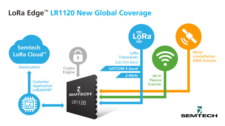
    The new LoRa Edge LR1120 enables satellite-based networks and simplifies terrestrial network interoperability

    Image: Semtech
    Image: Semtech

    Semtech Corp. has added multi-band capabilities to its LoRa Edge device-to-cloud geolocation platform.

    The LoRa Edge LR1120 allows for direct satellite-connected internet of things (IoT) applications in supply-chain management and logistics with seamless low-power geolocation on a global scale, the company said.

    “Semtech’s LoRa is targeting track and trace challenges faced by the logistics industry today with a geolocation IoT platform adapted to global transportation and mass-scale asset management,” said Marc Pégulu, vice president of IoT product marketing for Semtech’s Wireless and Sensing Products Group. “With the launch of multi-band LoRa support, coupled with LoRa Cloud services, it has never been easier to expand ubiquitous IoT connectivity and geolocation globally.”

    With LoRa Edge LR1120, intercontinental logistics companies can leverage highly integrated, ultra-low-power trackers with enhanced interoperability, more versatile connectivity for a simpler operation, and global mobility across multiple regulatory regions, Semtech said. Additionally, the possibility to offer a low-power and low-cost sensor with satellite connectivity unlocks a multitude of use cases in infrastructure monitoring, agriculture and environmental monitoring that require deployment in remote areas, which tend to be capital intensive.

    “Combining LoRa with small, relatively low-cost LEO satellites will change the game for LoRa and IoT,” said Christopher Taylor, director, RF & Wireless with Strategy Analytics. “Adding satellite communication capabilities in the S-band to LoRa can help replace aging SCADA monitoring and opens up new applications and markets, especially in remote regions. So far, LoRa has attracted the interest of several satellite companies including EchoStar and Lacuna.”

    Key Features of LoRa Edge LR1120:

    • multi-band LoRa capability (sub-GHz, 2.4 GHz and licensed S-band for satellite) and multi-technology geolocation using GNSS for outdoor and Wi-Fi for indoor, as well as areas where satellite coverage is poor
    • LoRa Cloud geolocation solver, which transfers the location processing workload from the device to the cloud, making “deploy once” battery life possible
    • supported by the GPS and BeiDou constellations
    • hardware crypto engine for increased security.
  • Xona’s private GNSS satellite passes pre-launch testing

    Xona’s private GNSS satellite passes pre-launch testing

    Xona has completed environmental testing for its upcoming demo mission, a significant step towards realizing its high-performance commercial navigation system

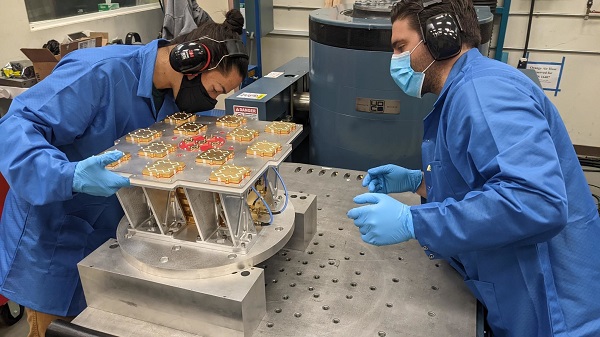
    Xona Space Systems announced that their first in-space demonstrator has been delivered to Spaceflight Inc. for final integration after successfully completing testing and is scheduled for launch on SpaceX’s Transporter 5 in May.

    Xona is an aerospace startup developing a precision navigation and timing system in low Earth orbit. It plans to build an independent high-performance satellite navigation and timing system to meet the needs of intelligent systems.

    Xona’s first demonstration mission successfully completed testing at Experior Laboratories and prepares for launch on a Falcon 9 in May. (Photo: Xona)
    Xona’s first demonstration mission successfully completed testing at Experior Laboratories and prepares for launch on a Falcon 9 in May. (Photo: Xona)

    Satellite navigation systems such as GPS and Galileo are in the domain of major governments (and free to users). Xona said it is part of the new commercialized space movement, using it to bring benefits to satellite navigation and timing.

    Xona Space is launching Huginn, the first of two missions, demonstrating the capability of its Pulsar constellation. Pulsar’s architecture uses small, powerful satellites in low Earth orbit, more than 20 times closer to Earth than GPS satellites, which are in medium Earth orbit.

    Pulsar is planned to deliver high-performance navigation and timing services by combining security and signal designs with Xona’s patent-pending distributed atomic-clock architecture to enable robust precision navigation services from low-cost satellites. Its precision LEO positioning, navigation and timing (PNT) service leverages advances in small satellite technology to provide users with a secure and robust alternative to traditional GNSS.

    Xona’s system architecture utilizes the efficiency of small satellites to provide an affordable global system with more than 10 times better accuracy and 100 times better interference mitigation than legacy systems, the company claimed

    Huginn will transmit the first precision navigation signals from a LEO spacecraft, designed to test and validate the core software and hardware technology that Xona has developed for Pulsar. The mission will also demonstrate the functionality of end-user equipment on Earth and supporting ground systems.

    Huginn is now going through final integration with Spaceflight in preparation for launch on the scheduled Transporter 5 mission in May.

    “We’re thrilled that Huginn has successfully completed its very rigorous test campaign in preparation for launch and are incredibly proud of the Xona team for achieving such a critical milestone,” said Brian Manning, CEO of Xona. “Through this process, we learned a massive amount and will be incorporating these lessons into our second demo mission as well as the production satellites.”

    Following the Launch of Huginn, the Xona team will shift focus to the second demonstration mission as well as the development of the Block I Pulsar system.

    The final Pulsar constellation will consist of several hundred LEO satellites, delivering secure and robust precision PNT services designed to meet the needs of advanced applications such as self-driving cars, precision agriculture and construction, augmented reality, critical infrastructure, and many others.

    “It is inspiring to see what this team has been able to achieve going from a blank slate to orbit in less than a year from the time we completed our ground-based prototype testing,” Manning said. “This is a huge step in the development and deployment of our Pulsar constellation, and we’re looking forward to a very exciting year here at Xona.”

    Xona is backed by Seraphim Space Investment Trust (LSE:SSIT) and MaC Venture Capital, with participation from Toyota Ventures, Daniel Ammann (co-founder of u-blox), and Ryan Johnson (former CEO of BlackBridge, operator of the Rapideye constellation). Follow-on investors also include 1517 Fund and Stellar Solutions.

  • Emcore contracted for navigation for space launch vehicles

    Emcore contracted for navigation for space launch vehicles

    Initial value of the contracts is expected to be more than $12 million

    Logo: EmcoreEmcore Corporation has been awarded new contracts for the Booster Rate Gyro (BoRG) and Tri-Axial Inertial Measurement Unit (TAIMU) programs for space launch vehicles resulting from its acquisition of the L3Harris Space and Navigation business.

    The BoRG program award is a contract valued at more than $12 million for the production of IMUs used for flight stabilization of the booster stage of a multistage launch system. The TAIMU program award is a development contract for the design and qualification of IMUs deployed for navigation and flight control of the upper stage of a multistage launch system.

    Pending successful demonstration of required capability and quality, Emcore expects to be awarded follow-on production contracts for TAIMU within the next 12 months.

    “We are honored to supply our highest grade inertial navigation equipment for these critical space launch vehicle programs,” said Albert Lu, senior vice president and general manager, Aerospace and Defense for Emcore. ”We look to further our close partnership with L3Harris through successful on-time deliveries for both the BoRG and TAIMU programs,” Lu added.

    Acquisition Closes

    Emcore’s acquisition of the L3Harris Space and Navigation business closed on May 2. Emcore acquired the business for approximately $5 million in an all-cash transaction, subject to any net working capital adjustments.

    The acquisition expands Emcore’s inertial navigation product portfolio with the addition of navigation-and strategic-grade gyro and inertial measurement unit products.

    Emcore acquired all outstanding assets and liabilities of the L3Harris Space and Navigation business, including all L3Harris intellectual property rights primarily used in the Space and Navigation business, a 110,000-square-foot leased production facility in Budd Lake, New Jersey, and associated production equipment.

  • U-blox and Geespace partner to extend positioning solutions to US, Europe

    U-blox and Geespace partner to extend positioning solutions to US, Europe

    U-blox and Geespace have signed a memorandum of understanding to expand their respective augmentation services for high-precision applications. Both partners will be able to extend their service offering to the U.S., European and Chinese markets, primarily in the automotive sector.

    Geespace is provider of aerospace information and communications (AICT) infrastructure and application solutions.

    The agreement between u-blox and Geespace seeks to create a combined offering that will enable both companies to offer full-stack high-precision positioning software and hardware solutions to customers across the United States, Europe and China. It will enable Geespace, which provides automotive GNSS augmentation services to its parent company Geely Group, to use the u-blox PointPerfect GNSS augmentation service to grow its coverage to serve Geely’s automotive brands.

    Meanwhile, it will enable u-blox to expand the coverage of the PointPerfect service to offer customers a comprehensive high-precision solution for products sold in China, and benefit from simplified development and logistics efforts.

    The rise of reliable and cost-effective high-precision positioning has improved the accuracy of GNSS solutions to the order of tens of centimeters, enabling new applications in the automotive, industrial and robotics industries. Global adoption has, however, been hampered by a fragmentation of the augmentation services landscape, the companies stated in a press release.

    For global adoption to become a reality, worldwide coverage is required, as is unified pricing and business models designed to serve mass-market high-precision solutions for automotive and industrial customers operating on a global scale, the companies said.

    Image: adamkaz/E+/Getty Images
    Image: adamkaz/E+/Getty Images
  • Septentrio expands product portfolio for marine market

    Septentrio expands product portfolio for marine market

    The housed AsteRx-U3 Marine and the OEM board AsteRx-m3 Fg are the two new GNSS receivers for dredging, marine construction and offshore applications

    Photo: CharlieChesvick/E+/Getty Images
    Photo: CharlieChesvick/E+/Getty Images

    Septentrio, a leader in high-precision GNSS positioning solutions, has launched two new GNSS products for marine applications: AsteRx-U3 Marine and AsteRx-m3 Fg.

    Both products offer accurate positioning near shore and offshore via centimeter-level real-time kinematic (RTK) or the built-in Fugro precise point positioning (PPP) sub-decimeter subscription service, delivered either over NTRIP internet or over L-band satellite.

    Corrections delivered over L-band allow dredging, bathymetry or marine construction projects even in areas where there is no internet service. The AsteRx-U3 Marine receiver, enclosed in an IP68-rated housing, offers a unique feature of a dedicated L-band demodulator with a separate L-band RF input, which allows for the use of dedicated antennas for excellent reception of L-band signals even at high latitudes.

    “The new products are designed around our most powerful GNSS core, bringing the latest evolution in GNSS technology to the demanding marine construction and dredging markets,” said Silviu Taujan, product manager at Septentrio. “They build on the success of the field-proven AsteRx-U Marine Fg and AsteRx4-Fg, with more processing power to allow tracking of all visible satellite signals while enabling higher update rates. AsteRx-U3 Marine and AsteRx-m3 Fg are both feature-rich receivers, combining the best-in-class RTK base and rover functionality with an option of sub-decimeter PPP positioning.”

    Orders for both products can be placed immediately. Deliveries for AsteRx-m3 Fg will follow the company’s standard lead times, while deliveries for AsteRx-U3 Marine will start from July.

    Septentrio GNSS technology is resilient to RF interference, which on vessels can come from satellite uplinks such as Iridium modems or from other radio antennas. Having robust GNSS technology means accurate and uninterrupted positioning on any vessel, even in challenging marine environments. Both AsteRx-U3 Marine and AsteRx-m3 Fg receivers offer accurate heading and pitch or heading and roll orientation information with the dual GNSS antenna configuration.