The U.S. Marine Corps has selected Northrop Grumman Corp. to provide it with the Next Generation Handheld Targeting System (NGHTS), a compact device that provides high precision targeting and can operate in GPS-denied environments.
The laser-based device will give Marines an enhanced capability to identify and designate targets from extended ranges, enabling them to identify ground targets under a wide range of conditions.
NGHTS can perform rapid target acquisition, laser terminal guidance operation and laser spot imaging functions. Its high-definition infrared sensors provide accuracy and grid capability over extended ranges.
Additional features include a high-definition color display and day/night celestial compasses.
The Mayflower Autonomous Ship (MAS) is set to re-embark on its three-week trans-Atlantic journey in April 2022 equipped with two of Silicon Sensing’s AMU30 inertial measurement units (IMUs). These devices send highly precise motion data to the new ‘AI captain’ that guides the vessel. They also assist in measuring sea surface height as part of detailed scientific analysis of ocean topography.
AMU30 is a micro electro-mechanical system (MEMS) unit with excellent inertial performance, including very good bias stability and low noise characteristics, plus an embedded Kalman Filter-based AHRS (attitude and heading reference system) algorithm. It delivers precise 3-axis outputs of angular rate and acceleration, plus roll, pitch and heading angles, altitude and pressure, and temperature, at 200 Hz — all critical to precise maritime navigation.
“The two AMU30 are used to make real-time, precision measurements of the movement of the Mayflower Autonomous Ship in 6 degrees of freedom (DOF) so that the AI Captain may make minute manoeuvring adjustments to optimise vessel performance in a complex wavefield, while also providing redundant general navigation capability at sea,” said Brett Phaneuf, co-director of the project. “Furthermore, when coupled with optical and RTK (real time kinematics) GPS data, the AMU30 assists the ship in making highly accurate measurements of sea surface height, which are important for studying ocean tides, circulation and the amount of heat the ocean holds.”
The MAS journey across the Atlantic will celebrate the voyage of the original Mayflower some 400 years ago. It is just one element of an extensive scientific data gathering and research programme the vessel will complete in the coming years. The ship is guided by its new AI Captain, built using IBM cloud, artificial intelligence (AI) and edge computing technologies, and uses a hybrid engine that draws on solar power. Working with scientists and other autonomous vessels it provides a flexible platform for deepening understanding of issues such as climate change, ocean plastic pollution and marine mammal conservation. In parallel, the development of marine autonomous systems such as this will transform ocean-related industries such as shipping, oil & gas, telecommunications, security & defence, fishing & aquaculture.
Last month we attempted to provide an overview of the issue concerning Federal Communication Commission’s (FCC) licensing of C-Band radio spectrum, the subsequent fielding of wireless service for 5G phones and the Federal Aviation Administration’s (FAA) announcements that potential interference could be possible between 5G signals and C-Band radio altimeters on commercial aircraft.
Not a big deal most people might say, as faster and improved phone and data messaging on their smartphones begins to kick in, while wireless companies continue roll-out of the new 5G service. But wait – don’t some of these people fly out on vacation and then back and land at local airports, and many of us fly around the US to visit friends and family, or each week shuttle around the country doing fly-in/fly-out business?
Well FAA and the wireless companies have largely collaborated during 5G service roll-out, and the FAA has been rapidly clearing a good number of rad-alt (radio altimeter) equipped aircraft to continue regular operations into most airports. And it seems that wireless companies have limited 5G fielding around some US airports by reducing transmitted power and/or limiting the density of 5G towers.
But where are we now? Seems some aircraft equipped with some types of rad-alt can fly into some airports – the FAA published a list for aircraft operators and pilots identifying who can do what and where. They also published several ADs (Airworthiness Directives) which limit several aircraft types from flying into certain airports, ‘prohibiting certain operations, which require radioaltimeter data to land in low visibility conditions, when in the presence of 5G C-Band interference’. For any aircraft passengers flying into LaGuardia on a foggy day or Boston when ice-fog hangs in the air – low visibility landing capability on modern aircraft is a blessing and a wonder which allows us to travel, even in bad conditions.
Seems that, typically – ‘many systems on (XY Type) aircraft rely on the radio altimeter, including autothrottle, ground proximity warning, thrust reversers and Traffic Collision Avoidance System,’ says one recent FAA AD.
That’s a whole bunch of critical systems which help an aircraft land. Many experts over many years have spent whole careers supporting the process of developing safety systems for auto-land and those which assist in the manual landing of aircraft. And the FAA and other agencies around the world have made every manufacturer prove and prove again that these systems work and work extremely, reliably, well.
Not that I’m against 5G – I have a 5G phone and I’m eagerly waiting for 5G applications to use on my phone. – the service seems to be very fast when in an area where 5G has been fielded. There are some wireless companies who have decided that 5G can by-pass cable in the distribution of TV channels – this is good stuff! Let’s have more of it!
But why on earth do we need to even partially compromise any aircraft systems which safely land aircraft?
Japan and France have been cited as counties in which 5G has not had any impact on the very same aircraft and their operations with which the FAA has found problems. Well, except those countries seem to have taken steps in the fielding of 5G which have protected their aircraft operations. The FAA quotes several mitigations used in those countries:
• Lower power levels
• Antennas adjusted to reduce potential interference to flights
• Different placement of antennas relative to airfields
• Frequencies with a different proximity to frequencies used by aviation equipment
Let’s hope that FAA’s intense efforts to test and clear rad-alts under the simulated intensity of C-Band interference around airports will continue unabated and that soon we aviation nuts will begin to breath more easily.
And let’s hope that the wireless companies cooperation, acceptance and mitigation steps – for which the whole aviation community is extremely grateful – that these very positive steps will directly lead to the whole issue fading away over time as old news.
And then a few words about ‘the war‘ which Russia just began against its neighbor and previous member of the USSR – Ukraine has been independent from Russia since the USSR ‘dissolved’ (Wikipedia) in 1991.
Ukrainians are pretty resilient and the news today is that a woman in Kyiv brought down a Russian drone by throwing a jar of pickles at it from her (high-rise?) balcony. This story of course isn’t verified, but it’s a small lightness in a very grim situation.
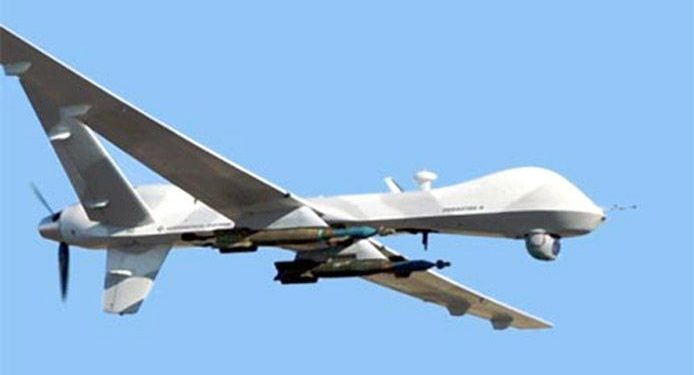
General Atomics armed MQ-9 Reaper (Militaryanalizer.com)
And its reported that Poland just placed an urgent operational requirement for armed MQ-9 Reapers in order to better protect its Eastern border with Ukraine. The border is around 530 miles long and is the main crossing point for the thousands of refugees fleeing the Russian onslaught. Poland has apparently already taken in almost a million people seeking safety.
Drones are now part of modern warfare and both East and West have pretty sophisticated, capable, weapon-carrying unmanned aircraft. But they also usually carry highly accurate satellite navigation and laser-guided weapons which may minimize unintended casualties – unless casualties are exactly what the Russians are after.
Really sad state of affairs which we all may still follow in detail through news reports, even though Russia has completely shut down social media and virtually outlawed on-the-ground news reporting.
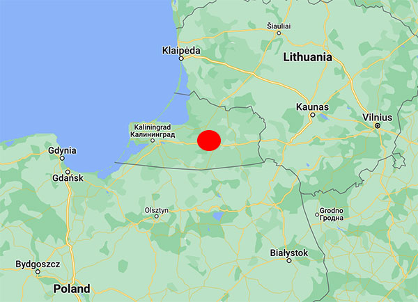
No cause for the abnormalities has been determined, but the vicinity to the Russian border during the Ukraine war seems to indicate intentional interference. In particular, interference occurs near the Russian province of Kaliningrad situated between Lithuania and Poland, both NATO members.
An aircraft operated by Lithuanian carrier Transaviabaltika has been unable to fly from Tallinn to Savonlinna for three days.
Traficom, the Finnish Transport and Communications Agency, has received numerous occurrence reports regarding GPS signal interference observed by aircraft. The interference began during the weekend and is still continuing.
On Tuesday, several aircraft reported GPS signal interference in the region around Mikkeli, Jyväskylä and Kuopio. An aircraft operated by Lithuanian carrier Transaviabaltika has been unable to fly from Tallinn to Savonlinna for three days.
Kaliningrad is the capital of the Russian province of the same name, sandwiched between Poland and Lithuania along the Baltic Coast. (Map: Google)
After receiving reports about GPS interference, Traficom on Monday requested Fintraffic Air Navigation Services Ltd (Fintraffic ANS) to issue a Notice to Airmen for pilots flying in the area.
“Flying is still safe. Airlines have procedures they follow if the GPS signal is lost,” said Director Jari Pöntinen. “Aircraft can use other systems to navigate and land safely. Air traffic control supports aircraft pilots with the help of other landing systems.” For final approach, traditional approach systems do not require a GPS signal.
Airlines make their own decisions on whether they can operate in an area where there is known to be interference to the GPS signal.
Traficom does not know what is causing the interference, but stated it will continue to monitor the situation and gather more information on the matter.
With Congressional approval of $17 billion in infrastructure funding, the largest single allocation ever, the scramble to win contracts is about to get red hot and AEC firms are gearing up. In this very competitive game, top engineering firms are relying on their experience, technology, business acumen and ability to execute.
Advances in aerial mapping play a key role in how AEC firms pursue these contracts. Savvy firms have been using this technology for years. Rather than rely on lower resolution satellite imagery or local drone imagery, they use wide-area-coverage aerial maps to clearly display the detail needed to plan and execute.
Over the past decade, maps made using aerial photogrammetry have played an important role in the AEC space. Using high-performance cameras, fleets of planes capture hundreds of square miles per plane per day, provided that the weather is clear. The imagery is processed and made available to engineering companies within days of capture, allowing them to see very clear imagery.
AEC organizations use different forms of aerial maps to evaluate sites, improve their survey designs, and build and maintain infrastructure (roads, highways, bridges, tunnels, overpasses, rail, airports, housing, commercial building development, water resources, parks, pavement and more). Imagine you’re a state or local government that needs to build a bridge, or a developer who wants to contract with an engineering and construction firm to build affordable housing. Why travel to perform time-consuming site evaluations when you can meet with engineering teams in your office and review hundreds of potential sites instantly using current aerial photos that show change over time?
The engineering teams point out elevation changes, the presence and height of vegetation, neighboring communities, bodies of water, ponding and more. They easily navigate from one location to another as you discuss where the entrance to the community could be, how the road network might be configured, and the proximity to retail, schools and healthcare. Within minutes you measure risk, understand the landscape, make decisions, and begin to estimate the project costs. Your teams collaborate, discuss the pros and cons, measure distances and navigate across the terrain virtually.
Aerial mapping provides a competitive advantage for AEC companies to win their fair share of the infrastructure bill. It also gives governments and developers the confidence they need to make the right decisions. Typically, this involves looking at sites from all angles. The classic form of aerial mapping used by engineers is a top-down perspective. Increasingly, these organizations have used oblique imagery captured at an angled perspective, which shows height.
Artificial Intelligence and Aerial Photography
Starting a few years ago, 3D imagery and digital surface models began to allow engineers to navigate through the imagery and query it based on elevation. More recently, aerial mapping has leveraged artificial intelligence (AI) to classify properties and the landscape. Do you need to see nearby construction sites? AI applied to aerial photography can do that automatically. This rich set of data includes attributes such as tree overhang, roof condition, roof material, building footprints, vegetation height, surface material, swimming pools and even solar panels.
The blend of all these imagery types and AI into a single solution makes everything discoverable. Users can search by address, city, location or point of interest. They can visualize the imagery along with lat/long coordinates and quickly switch from top-down views to obliques to 3D. As they learn more about the landscape, they begin to turn on AI attributes, gaining deeper insights.
Sometimes, the analyses go even further. Engineering organizations export the imagery to tools of their choice from such companies as Autodesk, Esri or Bentley Systems, use field-collected ground control points to ensure that it is survey grade, then use it as a base layer for their designs. They even create marketing presentations and video content to help them win the business. Current high-resolution aerial maps have become a cornerstone of how these organizations operate.
This approach provides unique advantages for engineering firms. For example, they can combine geospatial and construction datasets in a common operating environment to reduce complexity, streamline communication, ensure that all stakeholders are up to date, and check their progress toward meeting contractual obligations.
Planners have current, contextual designs and models to make accurate decisions about planning and development activities. They can view asset locations and conditions to facilitate maintenance and upgrades, leverage aerial maps inside other platforms to improve work orders and reduce field visits, and ensure regulatory compliance.
Whether it’s improving highway safety, constructing ferry terminals, improving transportation systems, developing land or building a network of recreational trails, aerial imagery provides engineering and construction companies with a competitive advantage to win new business, improve client satisfaction and meet growth targets. With $17 billion on the line, sophisticated firms are finding a way to secure their fair share of the pie.
Registration for the Institute of Navigation’s (ION) Joint Navigation Conference (JNC) 2022 is open and the technical conference program is now available online.
The JNC, sponsored by the Military Division of the Institute of Navigation (ION), will be held June 6–9 at the Town and Country Hotel in San Diego, California. JNC 2022 is a Federal Employees and Contractors U.S.-only conference. Advance visit requests and approvals are required for all attendees.
The event focuses on technical advances in PNT with emphasis on joint development, test and support of affordable PNT systems, logistics and integration. From an operational perspective the conference will focus on advances in battlefield applications of GPS; critical strengths and weaknesses of field navigation devices; warfighter PNT requirements and solutions; and navigation warfare.
The theme of the 2022 conference will be Enhancing Dominance and Resilience for Warfighting and Homeland Security PNT. The technical program includes six panel discussions on Rapid Agile Development and PNT Technology Transition; MGUE Integration; National Critical Infrastructure Threat; Future Space-based Sources of PNT; Situational Awareness; and the Warfighter Panel.
To view the JNC 2022 technical program and register for the event, visit ion.org/jnc.
The Federal Aviation Administration (FAA) and Association for Unmanned Vehicle Systems International (AUVSI) will co-host the 2022 FAA Drone Symposium April 28 in Orlando. The event will take place at the Orange County Convention Center.
The 2022 FAA Drone Symposium (formerly the FAA UAS Symposium) will focus on commercial operations, both at home and abroad. According to the show organizers, this collaborative event brings together industry and key FAA personnel to share best practices and lessons learned from operations, discuss challenges, and chart the course for the future of drone integration.
Session topics will include drone supply and demand, Beyond Visual Line of Sight Aviation Rulemaking Committee (BVLOS ARC) insights, drone integration and airspace integration.
Registration for AUVSI XPONENTIAL 2022 is now open. The conference will be held April 25-28 at the Orange County Convention Center in Orlando, Florida.
The XPONENTIAL 2022 theme is “Autonomy Meets Society.” The conference will include keynotes, educational sessions, specialized workshops, and an XPO Hall with 650+ exhibits.
Sessions will feature concentrated presentations, panel discussions, and audience questions to help drive deeper conversations and solutions to some of the industry’s greatest hurdles.
Session themes include:
Convergence Zone: Intersection w/ Businesses
Critical Point: Intersection with Government
DRONERESPONDERS Public Safety Forum
FULL JOIN: Intersection with Data
Interchange: Intersection with Industries
Nexus of Future Mobility: Intersection with Individuals
Proving Grounds: Enterprise + Government Solutions
Technology Crossing: Intersection with Design
Collaborative workshops will provide XPONENTIAL attendees an in-depth look into targeted topics and the solutions needed to harness the full potential of uncrewed technologies now and into the future.
Workshops include:
Orange you Glad Florida is Investing in Autonomy?
Robotics for Conservation
Translating Sustainability
Assured Autonomy Through Safety Performance Monitoring
The Safety Target
Connectedness: How Federal-State-Local Governments are Conquering Implementation Challenges Together
Accelerating Innovation Through Diversity of Thought
DoD Agile Acquisition Workshop – INVITATION ONLY
To view the XPONENTIAL 2022 schedule and exhibitors list and register for the event, visit XPONENTIAL’s website.
Combined geospatial solutions improve operations using location intelligence and mapping
Locana and Bent Ear Solutions are collaborating to provide location-based solutions that help customers improve their performance and decision-making across the organization, including their operations center. Locana was formerly known as Critigen.
The companies will work closely with clients and identify issues, challenges and mission priorities to modernize their geospatial capabilities and improve organizational effectiveness using location intelligence and mapping.
“Leveraging the complementary skills and expertise each company provides, clients gain tremendous value with focused and optimized technology, services, training, and support,” said Mike Eggenberger, VP, North America Sales, Locana. “Locana and Bent Ear Solutions understand the power of location for gaining an accurate understanding of circumstances and acting with clarity and precision.”
Bent Ear Solutions maintains deep domain expertise in operations, crisis management and business continuity. The organization has a track record of providing configured, situational awareness based on geographic information systems (GIS) combined with targeted workflows that support multiple requirements.
Locana has an extensive history of successfully designing and delivering robust, large-scale geospatial projects. Integrating business systems with scalable GIS, Locana helps clients spatially enable their enterprise with location analytics and high-powered mapping.
“Locana and Bent Ear Solutions are both dedicated to being a trusted partner for our clients,” said Chris McIntosh, CEO, Bent Ear Solutions. “We have a unique opportunity to combine our areas of excellence to address their complex challenges. We believe our collaborative approach will help them maximize the value and use of GIS across the enterprise.”
Locana and BES combined will deliver tailored GIS solutions and integration that organizations need to overcome system silos and enable situational awareness. The partnership will supply strategic and tactical planning, workflow development, team-building processes, documentation, procedural support and systematic training and exercises.
The result is long-term value in the form of access to sophisticated analysis and actionable intelligence, the companies said.
Linx Technologies has introduced seven GNSS active ceramic-patch antennas. These antennas support global GNSS applications including GPS, Galileo, GLONASS, Beidou, NavIC and QZSS systems in the L1/E1/B1, L2/E5/B2B, and L5/E5/B2A bands.
Each antenna integrates a high-gain low-noise amplifier (LNA) and right-hand circular polarization (RHCP) to provide a high-performance solution for GNSS signal reception. Each active GNSS antenna has either a 60-mm or 100-mm coaxial cable terminated in a MHF1/U.FL-type plug (female socket) connector.
“Linx Technologies continues to expand our popular GNSS antenna portfolio by adding more L1 options to serve our customers’ varied size and performance requirements,” said Linx CEO, Tolga Latif. “Our new active ceramic patch GNSS antennas also meet the need for multi-band L1/L2, L1/L5, and L1/L2/L5 GNSS offerings.”
The new active GNSS antennas are available now via Linx Technologies’ distributor and manufacturer representative networks. For larger quotes, contact Linx Technologies at [email protected].
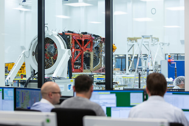
Galileo second-generation satellites will be constructed at the Integrated Technology Centre (ITC) at Friedrichshafen, Germany. (Photo: Airbus)
Airbus satellite design passes important project milestone, preparing for industrialized manufacturing concept
Airbus has successfully completed the preliminary design review (PDR) for its system concept for the second-generation Galileo navigation satellites. During this important milestone, Airbus’ proposed preliminary design and the customer’s system requirements have been fully reviewed and agreed upon. Galileo is managed and funded by the European Union.
This milestone paves the way for further verification, acceptance and qualification at the equipment and module levels. Verification at the payload level is already in full swing, with the critical design review (CDR) for the satellite structure due shortly.
In parallel, the Airbus site in Friedrichshafen, on Lake Constance, is preparing for an industrialized production line for six second-generation Galileo satellites. The satellite integration center is being upgraded to meet requirements for these satellites.
Galileo Second Generation Batch#1B satellites. (Image: ESA).
Airbus is bringing to the project more than 200 highly skilled space engineers. The first Galileo second-generation satellites are expected to launch in 2024.
The second-generation Galileo satellites will make the Galileo service more accurate, secure, dependable and adaptable. Weighing 2.3 tons, each satellite is designed to operate for about 15 years. The all-electric medium-Earth-orbit (MEO) platform from Airbus reuses building blocks from the company’s telecoms and Earth observation programs. The flexible and modular navigation payload is also based on telecom elements for beam forming and signal generation.
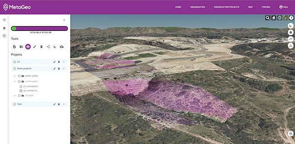
MetaGeo has launched a geographic information system (GIS) platform to enable organizations of all sizes to host, analyze, find and share 3D map datasets among any internet-capable devices.
The platform processes location-based map or sensor data from the real world, combines it into a single 3D virtual environment, and streams it to any device or mapping platform.
The affordable and easy-to-use platform can load data from multiple sources: satellites, drones, mobile devices, public and crowdsourced repositories, internet of things (IoT) sensor data, 3D models and topographic maps.
The data is then processed by the MetaGeo platform into a 3D world and streamed to any internet-connected device, enabling live collaboration between the office and field via mobile or AR device. A plug-in software development kit (SDK) allows for third-party tools to scale and fit user needs.
Applications include academia, architecture, engineering, construction, energy, natural resource management, environmental monitoring, utilities and public safety. Uses include planning and managing construction sites, organizing layouts of events, creating maps for public safety, and visualizing inspection imagery from drones and mobile devices.