The open access portal for NAVIGATION: Journal of the Institute of Navigation is now live at live at navi.ion.org.
“ION has partnered with HighWire Press to host its new open access portal for NAVIGATION giving readers a sophisticated platform that offers superior search tools, advanced research capabilities, new citation tools and article alerts,” said Lisa Beaty, ION’s executive director.
“NAVIGATION’s open access portal will allow for the rapid dissemination of cutting-edge, high-impact research across the breadth of the field of positioning, navigation and timing (PNT) as well as all related areas intersecting with PNT,” Beaty added.
PNT researchers, academicians and industry members can now access free and open research through NAVIGATION’s new portal. The portal makes it easier to:
download NAVIGATION open access papers for reading, sharing and citating
The appropriation for fiscal year 2022 enacted this month included $15M for “Position navigation and timing [PNT] technologies and global positioning system [GPS] backup” in the Department of Transportation (DOT) budget. At first glance, this might seem like a small but important step toward establishment of the system or systems President Bush mandated in 2004, the Obama administration promised in 2015, and called for by law in 2018.
Make no mistake, having the issue mentioned in the act is a very positive step. Unfortunately, a careful read of the report that came with the appropriations act shows the funds are not for solving, but for continuing to admire, the problem.
Here’s what the appropriation report says (in italics) and what it means. This is based on our reading of the text and conversations with hill insiders who said they had a tough battle with the administration to get any funding or mention of PNT or “GPS backup” in the budget at all.
“The agreement provides $15,000,000 to establish a program…” – This is not really a lot of funding for any federal effort. It is enough to hire several people, set up an office, and maybe do a few studies.
Notice that the appropriation language talks about “[leading] to wide adoption of multiple technologies.” It makes no mention of establishing any systems or signals.
Theoretically, this might be done by following the path in the Trump administration’s 2020 Executive Order on responsible use of PNT. The order addresses critical infrastructure and encourages such users to protect themselves with alternate PNT services they find on their own.
DOT might try this with all users to achieve “wide adoption,” though there are many obstacles. Principal among these is that GPS is free while commercial services are not. Providers of alternative PNT services have long recognized that it is impossible for them to compete with free GPS and argued that the government needs to be the customer.
“…Funding will enable, among other things…” An interesting turn of phrase that seems to say, ‘you must do all of this, but if you have any money left over you can do other things.’ This is pretty much a throw-away phrase since, with this worklist, they won’t have money left over for anything else. In fact, they will probably come up short.
“…the development of safety-critical PNT requirements and standards…” In other words, study the problem some more. Developing requirements and standards is important, but it doesn’t provide anything for the United States to use when Putin jams GPS or there is a huge solar storm.
“…vulnerability and performance testing…” Again, more study and little to no progress implementing solutions.
“…certification protocols for safety-critical functions”… Still more study.
“…the procurement of services as deemed appropriate by the Department…” Some might see this as a ray of hope. It could, conceivably, allow DOT to contract for PNT signals from space, fiber, or terrestrial broadcast and move toward establishing one or more systems. Unfortunately, $15M isn’t much for such an effort, even if DOT didn’t have to also create an office and do all the required studies and standards. In this context “services” almost certainly means contracted staff to help with administration and hiring think tanks.
“…and user adoption models in order to facilitate the responsible use of resilient PNT services to meet Federal requirements for widespread adoption.”
Since there are no “federal requirements for widespread adoption” to meet, this seems like another throwaway phrase that someone thought sounded actiony and proactive.
Additionally, we are not sure what a “user adoption model” is.
The best translation we can come up with is “DOT must figure out how to get Americans to adopt alternate PNT services that are either expensive or haven’t been invented yet. All in the absence of a government mandate for them to do so.”
Most in the PNT community have long recognized the need to “get the bullseye off of GPS” by making it a less attractive target, while at the same time protecting the nation against a wide variety of threats to satellites and signals. For them, the language in this year’s appropriation bill can be discouraging.
Yet there is some reason for hope. At least the problem was discussed in the bill, and some money was put toward it, regardless of how flawed the underlying assumptions and mandated actions might be.
Maybe we should all take comfort in the old Hollywood maxim – “It doesn’t matter what they say as long as they are still talking about you.” Let’s all keep the conversation going.
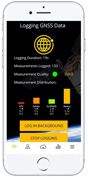
A new Android app released by the European Space Agency (ESA) turns smartphones equipped with dual-frequency GNSS receivers into instruments for crowdsourced science.
The CAMALIOT app, developed through ESA’s Navigation Innovation and Support Programme (NAVISP) with the support of the GNSS Science Support Centre, is suitable for more than 50 smartphone models.
Using the CAMALIOT app, the phones will record small variations in satellite signals, gathering data for machine learning analysis of meteorology and space weather patterns.
As well as helping to create new Earth and space weather forecasting models, participants are also in with the chance to win prizes including new phones and Amazon vouchers. This four-month “citizen science” campaign runs until the end of July.
“The precisely modulated signals continuously generated by the dozens of GNSS satellites in orbit are proving a valuable resource for science, increasingly employed to study Earth’s atmosphere, oceans and surface environments,” said ESA navigation engineer Vicente Navarro. “Our GNSS Science Support Centre was created to help support this trend.”
For instance, tens of thousands of permanent GNSS stations are continuously recording GNSS data. As the satellite signals travel down to Earth they are modified by the amount of water vapor in the lower atmosphere, helping to forecast rainfall in particular.
GNSS signals also undergo delay and fading — known as scintillation — as they pass through irregular plasma patches in the ionosphere. This electrically charged upper atmospheric layer is continuously changing, influenced by solar activity, geomagnetic conditions and the local time of day. Dual-frequency GNSS receivers can compensate for this effect by comparing their two frequencies.
“The combination of Galileo dual band smartphone receivers and Android’s support for raw GNSS data recording is what opened up the prospect of supplementing data from these fixed GNSS stations with tens of millions of smartphones, vastly increasing our density of coverage,” Vincente said. “We took inspiration from the famous ‘SETI@home’ initiative, where home laptops help seek out signs of extraterrestrial life.”
The results can then undergo a Big Data machine learning approach, seeking out previously unseen patterns in both Earth and space weather.
“This is our first step in enlarging GNSS data acquisition using an internet of things data-fusion approach, employing novel sources such as fixed sensors and drones as well as smartphones,” Vincente said. “A wide range of other applications are also possible for the system, including improving the performance of GNSS systems.”
Formally known as the Application of Machine Learning Technology for GNSS IoT Data Fusion project, CAMALIOT is run by a consortium led by ETH Zurich (ETHZ) in collaboration with the International Institute for Applied Systems Analysis (IIASA).
“The CAMALIOT effort was underpinned by Element 1 of our NAVISP research programme, spurring innovation in satellite navigation,” said Pierluigi Mancini, ESA’s NAVISP program manager.
A link to the live event will be sent to you two hours before the event. Your personalized event URL will be automatically generated by the ON24 system. To ensure receipt of the email, please whitelist this email address by adding it to your contacts: [email protected].
This presentation will begin at 1 p.m. EDT / 10 a.m. PDT on Thursday, April 28. A recording will also be sent to you the following day so you can watch it on-demand.
Audience members may arrive 15 minutes prior to live time. If you have any questions, please contact event producer Aurora Harris at [email protected].
A “BeiDou positioning system for subways” began construction March 20 on the Beijing subway capital airport express line. The project will cover a 30-kilometer-long section of the express line, including five stations.
To provide positioning, the BeiDou Navigation Satellite System (BDS) will be combined with 5G for indoor positioning or in areas where the satellite signals are blocked.
The system will improve the positioning accuracy in subways to less than two meters, making it available for vehicle dispatching, passenger transport organization and emergency response. In addition, it allows passengers to use their phones to navigate and position in complex environments in subway stations through three-dimensional navigation.
“We will combine indoor and outdoor positioning in subways, that is, Beidou and its augmented reality technology will be used outdoors to achieve high-accuracy positioning, and indoor positioning technology integrated with 5G will be used to allow users to receive indoor positioning signals,” said Lin Luzhou, vice president of the GNSS and LBS Association of China.
The project is the largest indoor space navigation and positioning system in China, according to ECSN.com, and is expected to be finished within this year.
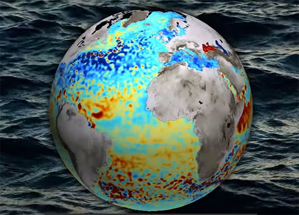
Monitoring the constantly changing shape of the sea surface is important for scientific and societal applications such as ocean current forecasting, climate research, ship routing, cable laying and debris tracking.
A project supported by the Discovery element of ESA’s Basic Activities recently investigated a technique to precisely measure sea-surface topography. The project was based on an idea submitted by the Institute for Space Studies of Catalonia (IEEC) through the Open Space Innovation Platform (OSIP) — ESA’s place for your space ideas.
The technique involves GNSS reflectometry — signals that have been reflected off of the sea surface at very low angles. At these “grazing” angles, waves and surface roughness have little impact on the reflection process; the sea surface acts as a very smooth mirror.
“In a mirror-like reflection the phase of the signal can be tracked — it is continuous,” explained IEEC’s Estel Cardellach, principal investigator and submitter of the OSIP idea. “Different surface heights result in different phase measurements. It gives a very precise measurement of the surface altitude at a few centimetres’ precision.”
Balearic Islands Project
The ESA-funded activity involved developing a GNSS receiver and setting up an experiment in the Balearic Islands to collect GNSS signals reflected off the sea surface. The team — made up of IEEC, imedea, SOCIB and DLR — then processed the signals for optimized measurements of the shape of the sea surface.
“Thanks to OSIP and ESA Discovery we have been able to conduct this experiment on grazing GNSS reflectometry under monitored conditions,” said Manuel Martin-Neira, ESA technical officer for the project. “We have linked the coherence of the reflected signals to wave height and the elevation angle of GNSS satellites. These results have been very useful for preparing the PRETTY mission.”
ESA’s PRETTY (Passive REflecTomeTry and dosimetry) CubeSat mission is a small satellite that will carry out grazing angle GNSS altimetry from orbit. It is due to launch later this year.
Expected to be available in the second quarter of this year, Trimble’s RTX service will enable superior location capabilities in premium Android smartphones worldwide.
The integration of Trimble RTX GNSS technology, a correction services platform, with Snapdragon contributes to a higher quality, more accurate location-based user experiences such as car navigation with lane-level guidance.
Coupling the Trimble RTX technology with premium Snapdragon Mobile Platforms will enable smartphone manufacturers, service providers and application developers using Snapdragon to provide mobile users with robust meter-level accuracy (or about 3 feet) when used with a Trimble RTX-based correction service. This represents a five times improvement in location accuracy compared to typical accuracy.
Location information accuracy can significantly improve the smartphone’s user experience when using mapping, driving or other mobile applications. For example, with more accurate positioning for a ridesharing app, both driver and rider can have a better experience when the pick-up destination is more precisely displayed. In addition, lane-level accuracy enables drivers to gain greater map detail and more accurate directions when using real-time navigation applications.
The new collaboration expands Trimble’s existing relationship with Qualcomm Technologies to provide high-accuracy positioning solutions for connected vehicles, advanced driver-assistance systems (ADAS) and autonomous driving solutions to automotive OEMs and Tier 1 suppliers.
“Trimble and Qualcomm Technologies have a history of innovation in mobile location technologies, both separately and collaboratively,” said Lisa Wetherbee, general manager of Trimble Advanced Positioning. “Together, we are boosting premium Android phone functionality, helping mobile applications provide better information about the user’s immediate surroundings.”
“Precise positioning, where accuracies are down to a meter or less, is a necessary capability in next-gen premium Android phones, providing better mapping, more accurate navigation and new exciting services to consumers,” said Francesco Grilli, vice president, product management, Qualcomm Technologies. “Snapdragon is again taking location-based experiences to a new level through this collaboration with Trimble.”
Smith Myers showcased ARTEMIS, a mobile phone detection and location system designed specifically for airborne search and rescue (SAR) and disaster relief, at a helicopter trade show in Dallas.
The company, founded 35 years ago in the United Kingdom, also designed and developed software-defined radio and cellular protocol stacks designed specifically for the SAR role. According to the company, ARTEMIS turns any mobile phone into a rescue beacon, only requiring two antennas to generate a latitude/longitude fix at up to 19 nautical miles (35 km), offering an alternative to traditional airborne sensors.
ARTEMIS’s features include:
texting and calls in no service areas
possible automatic cueing of electro-optical/infra-red (EO/IR)
deployment as a stand-alone with embedded mapping or integration with mission system providers
making missions in low light / instrument meteorological conditions (IMC) safer and more successful and
availability in several SWaP configurations for manned/unmanned platforms.
Smith Myers announced in February that ARTEMIS has been integrated into the new Robotics Centre Echo SAR payload for small unmanned aerial systems (UAS) built by Teledyne FLIR Defense.
ARTEMIS airborne capabilities are available for use on manned rotary and fixed-wing platforms and drones with large and small payloads. It has already been in service with the AW101 Norwegian all-weather SAR helicopter and can be deployed across payload categories down to a small quad-rotor UAV.
A new software app helps local governments in the UK plan alternative routes, infrastructure and access that facilitate walking and cycling in cities, reducing traffic. XMAP, a cloud-based web geographic information system (GIS) for local governments from Geoxphere, now offers Isochrone. It provides a detailed and visual insight into existing transport infrastructure, assessing accessibility and the local environment to calculate and compare travel times by foot, cycle and car. The tool enables planners to understand how the existing infrastructure is enabling or restricting green journeys. It also helps them model and visualize how improvements to the transport network can be made and engage with communities to promote specific schemes and opportunities for active travel.
The XMAP Isochrone tool allows a user to create polygons on a map showing how far it is possible to drive, walk or cycle in a set amount of time. Using algorithms that take into consideration the actual road, foot path or cycle network, as well as historic speed data and average walking and cycling rates, it provides a more accurate methodology of calculating travel times compared to traditional concentric circles based on straight line distances.
XMAP is accessible from any web-enabled device, without plug-ins, bolt-ons or additional installations. It includes a suite of inbuilt workflows to support delivery of local government services such as planning, housing, waste and recycling, and street services. XMAP comes complete with more than 250 geospatial data layers, from a variety of government agencies, as well as a fully maintained Ordnance Survey map stack.
Provided as a Software as a Service (SaaS), XMAP allows users to create and share business-critical map data without the risks involved in using open-source silos of GIS or the high cost of traditional GIS solutions. XMAP gives access to Ordnance Survey mapping, aerial photography, together with third party and in-house datasets, for more than 1,700 government organizations as well as a range of commercial clients.
Jack Dangermond, co-founder and president of geographic information system (GIS) giant Esri, told his customers on March 10 that he is “shocked and distressed by the grim circumstances in Ukraine.” Consequently, he announced, Esri and its distributor Esri CIS have stopped all their sales to Russia and Belarus. The company is also supporting several organizations across Europe “in their humanitarian and military efforts in support of the Ukrainian government and its people.”
“The invasion of Ukraine is a devastating chapter in our history,” Dangermond continued. “We have heard from so many members of our GIS community who, like us, stand with the Ukrainian people. Make no mistake, this is a daunting moment that will demand strength, compassion, and resolve from all of us.”
In the current context of the Russian invasion of Ukraine, the issue of GNSS jamming and/or possible spoofing has intensified in geographical areas surrounding the conflict zone and other areas, according to the European Union Aviation Safety Agency (EASA). The agency issued a safety information bulletin on March 17 warning of a GNSS outage leading to navigation / surveillance degradation. According to the bulletin, which was directed at national aviation authorities and airlines, reports analyzed by EASA indicate that since February 24 GNSS spoofing and/or jamming has intensified in four key geographical areas:
the Kaliningrad region, surrounding Baltic Sea and neighboring states
Eastern Finland
the Black Sea and
the Eastern Mediterranean area near Cyprus, Turkey, Lebanon, Syria and Israel, as well as Northern Iraq.
“The effects of GNSS jamming and/or possible spoofing,” the bulletin stated, “were observed by aircraft in various phases of their flights, in certain cases leading to re-routing or even to change the destination due to the inability to perform a safe landing procedure.” It pointed out that in the present conditions it is not possible to predict these outages and their effects. Potential issues include:
loss of ability to use GNSS for waypoint navigation
loss of area navigation (RNAV) approach capability
inability to conduct or maintain various operations
triggering of terrain warnings, possibly with pull-up command and
inconsistent aircraft position on the navigation display
loss of automatic dependent surveillance-broadcast (ADS-B), wind shear, terrain and surface functionalities
failure or degradation of ATM/ANS/CNS and aircraft systems that use GNSS as a time reference and
airspace infringements and/or route deviations due to GNSS degradation.
The bulletin also offers several recommendations to airlines for mitigating these issues.
Hexagon AB, a provider of digital reality solutions combining sensor, software and autonomous technologies, has acquired ETQ, a provider of SaaS-based quality management system (QMS), environment, health and safety (EHS) and compliance management software.
Customers have long relied on ETQ’s QMS solution, ETQ Reliance, which provides the data backbone for automating the collection and delivery of manufacturing quality control data, non-conformance reports, customer feedback and more, providing an enterprise view of quality management across a product’s lifecycle. Its portfolio of applications comes with out-of-the-box functionality and no-code configurability, enabling customers to tailor the solution to their needs and optimize business processes to achieve their quality, safety and environmental goals.
ETQ’s data management capabilities, driven by machine learning and artificial intelligence, make quality data fully actionable and available further upstream. In addition to reducing defects, scrap, rework, and recalls, it enables an autonomous feedback loop, digital information trail and virtuous cycle of continuous improvement.
Founded in 1992 and with a staff of 185, ETQ is headquartered in Massachusetts with additional offices in Arizona and Dublin, Ireland. It operates in industries including the life sciences, healthcare, heavy manufacturing, electronics, food and beverage, heavy process, and automotive. ETQ will operate as part of Hexagon’s Manufacturing Intelligence division. Completion of the transaction is subject to regulatory approvals and other customary conditions, which are expected to be fully completed by early in the second quarter 2022.









 Hexagon AB, a provider of digital reality solutions combining sensor, software and autonomous technologies, has acquired ETQ, a provider of SaaS-based quality management system (QMS), environment, health and safety (EHS) and compliance management software.