Blog

  • Qualcomm and Ferrari announce strategic technology collaboration

    Qualcomm and Ferrari announce strategic technology collaboration

    Qualcomm Technologies Inc. and Ferrari N.V. have entered a strategic technology collaboration aimed at helping accelerate the digital transformation of Ferrari.

    Qualcomm Technologies will serve as Ferrari’s systems solutions provider for its upcoming Ferrari road cars, as well as a Premium Partner for the Scuderia Ferrari Formula 1 team and Ferrari eSports team.

    Ferrari will work with Qualcomm Technologies to utilize the Snapdragon Digital Chassis to bring the latest automotive technology advancements to Ferrari road cars.

    The Snapdragon Digital Chassis is comprised of open and scalable cloud-connected platforms needed for next-generation vehicles, which includes telematics and connectivity, the digital cockpit, and advanced driver-assistance systems (ADAS) functions. It utilizes a unified architecture to deliver enhanced safety and immersive digital experiences  updateable throughout the lifetime of the vehicles.

    As a part of the agreement, Qualcomm Technologies and its partners will also work with Ferrari to design, develop and integrate Ferrari’s digital cockpits.

    Qualcomm Technologies will begin serving as a Premium Partner of the Scuderia Ferrari Formula 1 team at the start of the 2022 FIA Formula One World Championship race season, where Snapdragon will be featured on the new Scuderia Ferrari’s F1-75 single-seaters. The Maranello marque’s eSports activities will also be part of the official partnership.

    The Snapdragon Digital Chassis connects cars to the cloud. (Image: Qualcomm)
    The Snapdragon Digital Chassis connects cars to the cloud. (Image: Qualcomm)
  • Editorial Advisory Board Q&A: Russian threats to GPS

    Editorial Advisory Board Q&A: Russian threats to GPS

    Photo: Stanislav Ostranitsa/iStock/Getty Images Plus/Getty Images
    Photo: Stanislav Ostranitsa/iStock/Getty Images Plus/Getty Images

    Is Russia’s recent threat to destroy GPS satellites technically realistic? Specifically, how many satellites would it have to destroy to essentially incapacitate GPS-dependent U.S. weapons systems? Would the 1,100-km separation between the orbits of GPS and GLONASS satellites spare the latter from the debris field?

    Ellen Hall
    Ellen Hall

    “It appears technically possible because they destroyed one of their own retired Soviet satellites on Nov. 15 with anti-satellite technology. Russia threatened to destroy up to 32 satellites, which would incapacitate GPS-dependent weapons and create a virtual mine field of debris with little ability to project trajectories of debris fallout. It is imperative that LEO and ground-based sensor alternatives be developed that will make an enemy attack less likely to be incapacitating.”
    — Ellen Hall, Spirent Federal Systems


    Photo: Mitch Narins“Some still appear to believe that the number of satellites and their orbital height offer some level of protection. They refuse to look to the ground for resilient solutions using proven and highly reliable technology — which, coincidently, both Russia and China continue to operate as their resilient PNT solutions. The United States and its allies cannot continue to be dictated to by financial analysts who resist these solutions for fear of exposing the poor decisions they supported in the past and continue to support regarding a solution with a higher power and low frequency.”
    — Mitch Narins, consultant


    Bernard Gruber
    Bernard Gruber

    “Yes, it is technically realistic, but this act of war against a truly worldwide utility would be politically and economically disastrous. GPS IOC was based upon 24 MEO satellites that offered full, but not overlapping, worldwide coverage with spares — there are now 31 satellites that can be utilized through the control segment. The GPS constellation is ~1,100-km deeper than GLONASS. As made evident by the now-destroyed Kosmos 1408 debris cloud simulations, and the actual debris cloud spread by the Chinese 2007 ASAT test that now encompasses most of the LEO regime, the debris field will expand, thus increasing risk to GPS satellite placement and possibly risking physical damage to currently orbited satellites.”
    — Bernie Gruber, Northrop Grumman

  • ColdQuanta to develop atomic clocks for Office of Naval Research

    ColdQuanta to develop atomic clocks for Office of Naval Research

    Image: agsandrew/iStock/Getty Images Plus/Getty Images
    Image: agsandrew/iStock/Getty Images Plus/Getty Images

    Next generation of atomic clocks to provide improved performance, stability and durability for U.S. Department of Defense

    ColdQuanta has been awarded a 5-year subcontract to develop portable atomic clocks for the Office of Naval Research. ColdQuanta will serve as a subcontractor to Vescent Photonics, which secured the $15.6 million total award.

    Under the Compact Rubidium Optical Clock (CROC) program, ColdQuanta will provide the physics package with development inputs from the Atomic Devices and Instrumentation Group at the National Institute of Standards and Technology (NIST). The program began in November 2021 and will span three phases through 2026.

    As part of the CROC program, ColdQuanta and its partners will design, build and deliver a new generation of high-performance atomic clocks ready for field deployment at a high technology readiness level (TRL). Specifically, the program will interrogate a two-photon optical clock transition in a warm vapor of rubidium atoms to achieve improved stability and performance. The clocks will also offer reduced size, weight and power consumption.

    ColdQuanta is participating in the project alongside Vescent, which will provide optical frequency comb technology, and Octave Photonics and the Quantum Nanophotonics Group at NIST, which will supply crucial advances in non-linear nanophotonics. The outcome of the program will be 10 prototype field-deployable optical clocks at or above TRL 6 that exhibit long-term instability to better than three parts in 100 trillion and offer >50% reduction in power consumption.

    The CROC program will be conducted in three phases:

    • Phase 1: All critical technology elements advanced to TRL 6 and demonstrated in a modular clock.
    • Phase 2: Engineering and verification efforts to integrate the individual components into prototype clocks.
    • Phase 3: Manufacturing 10 final prototype clocks for ONR evaluation in relevant platforms.
  • Applanix introduces GNSS-inertial platform for mobile mapping

    Applanix introduces GNSS-inertial platform for mobile mapping

    New hardware and software platform provides accuracy, position for land-vehicle system integrators

    Photo: Applanix
    Photo: Applanix

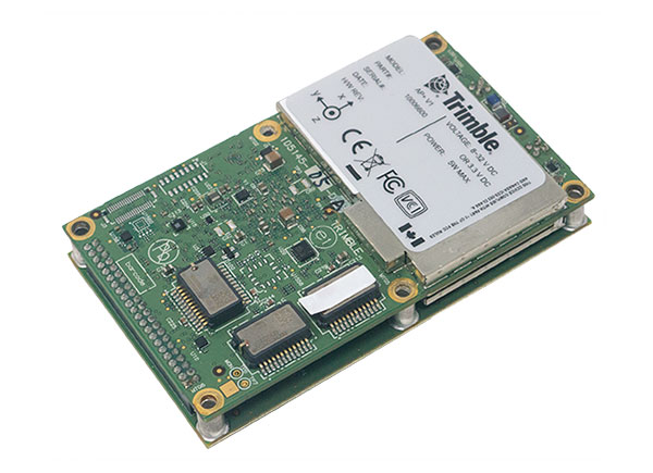
    Applanix, a Trimble Company, has announced the Trimble AP+ Land GNSS-inertial OEM platform for accurate and robust position and orientation for georeferencing sensors and positioning vehicles in land mobile-mapping applications.

    The platform enables users to accurately and efficiently track and monitor fleets and produce high-definition (HD) maps and 3D models. It can also serve as a reference solution for advanced driver-assistance systems (ADAS) testing, even in challenging GNSS environments.

    The comprehensive Trimble AP+ Land is small enough to integrate into compact mobile-mapping systems. It is compatible with virtually any type of mapping sensor, including single- or multi-lidar systems, video cameras, photogrammetric and panoramic cameras, and similar sensors.

    Configurable to meet the mapping, positioning and direct georeferencing (DG) accuracy demands of mapping and positioning applications in challenging GNSS signal environments, the Trimble AP+ Land solution features:

    • Applanix IN-Fusion+ GNSS-aided inertial firmware with Trimble ProPoint GNSS positioning technology
    • Dual embedded survey-grade GNSS chipsets that can receive multi-frequency and multi-constellation signals
    • Dual custom-designed inertial measurement units (IMU)
    • Distance measurement indicator (DMI)
    • Compact size
    • Low power consumption
    • Optional RTK and Trimble CenterPoint RTX real-time correction service support
    • Full integration and post sales support through the Applanix Global support network

    “We have taken the most advanced features of Applanix inertial and Trimble GNSS technology, and packaged them into a powerful compact and versatile solution optimized for mobile mapping and positioning applications,” said Joe Hutton, Applanix’s director of inertial technology, air and land products. “We remain committed to our customers’ success by developing flexible and scalable positioning solutions such as the AP+ Land and more.”

    The Trimble AP+ Land OEM solution is supported by the Applanix POSPac MMS post-processing software, which features Trimble CenterPoint RTX post-processing for centimeter-level positioning globally without the need for base stations. These capabilities make it a suitable for integrators to produce a highly efficient land mobile-mapping system.

    For lidar integrators, the Trimble AP+ Land OEM is compatible with the POSPac MMS LiDAR QC tools. SLAM technology computes the IMU to lidar boresight misalignment angles and also adjusts the trajectory to achieve the highest level of georeferencing accuracy in the generated point cloud.

  • ViaLite adds resilience to critical GPS timing services

    ViaLite adds resilience to critical GPS timing services

    Diagram: ViaLite
    Diagram: ViaLite

    ViaLite’s RF-over-fiber systems can carry GPS/GNSS timing signals over long distances with very low signal degradation. However, the same cannot be said of GPS signals before they reach the GPS/GNSS antenna, as these weak radio waves are highly susceptible to jamming or spoofing.

    Timing-critical infrastructures in areas such as defense and cyber security can now be protected from this kind of attack by installing one of ViaLite’s new GPS Protection Packages. The packages integrate either the GPS Resilient Kit or OtoSphere Protection Module products from Focus Telecom for jamming protection.

    The GPS Resilient Kit has two GPS antennas, which enables the direction of the attack to be pinpointed. At its heart is the small OtoSphere Protection Module, which has a unique interference filtering algorithm that combines the patterns from the two omnidirectional antennas.

    The module can analyze the direction from which the interference is coming and feed it into its algorithm, directing a null towards the unwanted signal to reject and reduce disruptions.

    Using OtoSphere, GPS receivers are up to 50 times more resilient to jamming attacks on positioning, navigation and timing (PNT) systems compared with having no protection. The GPS receiver is able to continue working normally throughout the attack.

    “ViaLite customers typically need the highest grade of reliability and service, particularly for critical infrastructure timing applications,” said Richard Jacklin, ViaLite sales director. “With the increase in jamming threats, both land-based and maritime, these Focus Telecom anti-jamming products are a perfect complement to our range of GPS/GNSS signal distribution solutions.”

    The Protection Packages can be integrated into new installations or retrofitted to existing ViaLite systems. The GPS Resilient Kit and OtoSphere are already IP-rated, so they can be simply added to outdoor installations. Alternatively, for a full package solution, the OtoSphere module can be integrated into the ViaLite ODE-MINI outdoor enclosure.

    The packages are suitable for use in critical infrastructure sectors such as defense, satcoms, utilities, cellular communications, broadcast, data centers and transportation.

    Other Focus Telecom products, introduced by ViaLite, include the GPSensor for monitoring GPS frequencies and reporting intentional and unintentional attacks, and the GPS RF Switch which protects PNT systems from vulnerabilities by isolating them from the RF signals coming from the antenna.

  • SBG Systems introduces its first tactical-grade IMU

    SBG Systems introduces its first tactical-grade IMU

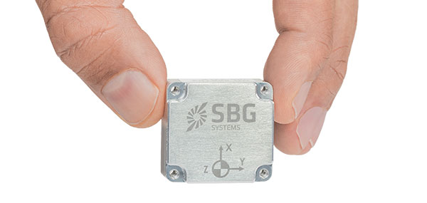
    SBG Systems is introducing the Pulse-40 inertial measurement unit (IMU), a tactical-grade IMU designed for high performance in harsh conditions, but miniaturized for applications where precision and robustness matter in all conditions.

    Use cases include warfare systems, satellite communications, robotics, lidar devices, gimbals, cameras and inertial navigation systems (INS).

    The Pulse-40 IMU provides six-degrees-of-freedom. It integrates micro-electromechanical (MEMS) three-axes accelerometers and gyroscopes in a unique redundant design that allows the device size to shrink while pushing performance to its maximum.

    Photo: SBG Systems
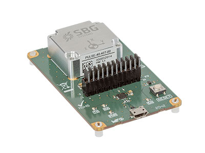
    The Pulse-40 on a development board. (Photo: SBG Systems)

    Among the performance specifications, the Pulse-40 features excellent gyro and accelerometer bias instability of 0.8°/h and 6 µg respectively, enabling long dead-reckoning and maintaining excellent heading performance. With sensors featuring extremely low vibration rectification error (VRE), the Pulse-40 is able to sustain high vibration environments, up to 10 g root-mean-squared.

    An embedded continuous built-in-test ensures data reliability during operation, a key parameter for critical applications. The Pulse-40 requires no periodic maintenance. An intensive qualification process — including accelerated aging — guarantees that the sensor behavior is stable over time.

    Photo: SBG Systems
    Photo: SBG Systems

    Main Features

    • Size, weight and power (SWaP) design: 12 grams, 0.3W Power consumption
    • Ultra-low noise gyro (0.08°/√h) and excellent gyro bias instability (0.8°/h)
    • High-precision accelerometers (6 µg)
    • Low vibration rectification error: shocks and vibrations MIL-STD 810 qualified
    • High bandwidth (480Hz) and high data rate (2KHz)
    • Highly tested and calibrated from –40° C to 85° C
    • No export restrictions

    Research Result

    SBG Systems’ sensor calibration and validation tools, initially based on a single axis motion simulator with a temperature chamber, have evolved over the years and are now based on 100% automated, multi-axis motion simulators with temperature chambers. The high level of automation mitigates human-error risk and ensures that all the delivered products meet their specifications. Its  INS are the result of extensive research in signal processing, micro-electronics, calibration algorithms and sensor qualification, the company said.

    With very low gyro noise and bias instability, the navigation performance is maximized in GNSS-disturbed or -denied environments. The Pulse-40 is export license free and ITAR free.

  • OxTS announces new xNAV650 post-processed specifications

    OxTS announces new xNAV650 post-processed specifications

    Photo: OxTS
    Photo: OxTS

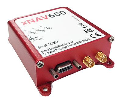
    In 2021, OxTS released its smallest, lightest and most affordable inertial navigation system (INS) to date — the xNAV650.

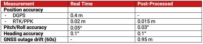
    At release, the xNAV650 detailed real-time specifications only. However, after additional testing, OxTS has announced post-processed specifications.

    Photo:

    Because of its small size and low weight, the xNAV650 is suitable for SWaP-constrained applications. It is also used in many mobile-mapping scenarios. Alongside OxTS Georeferencer, measurements created by the xNAV650 can be used to georeference point clouds from multiple lidar sensors.

    By announcing these new specifications, OxTS aims to keep surveyors informed of the performance they can expect from the xNAV650 in both real time and post-processing.

    OxTS has been manufacturing INS for more than 20 years. Their INS are widely used in both the automotive testing and survey and mapping industries.

  • Tallysman adds north orientation mark to TW3000, TW5000 antennas

    Tallysman adds north orientation mark to TW3000, TW5000 antennas

    Photo: Tallysman
    Photo: Tallysman

    Tallysman Wireless is introducing a north orientation mark to its TW3000 family of Accutenna precision antennas and its TW5000 family of smart antennas.

    The new feature will allow customers to align their antennas, standardize radiation patterns, and increase the synchronicity of their azimuth gain readings across multiple devices.

    The new north mark design has been thoroughly tested to ensure it conforms to or exceeds customer expectations and maintains each antenna’s stringent IP69K rating.

    The new design will be introduced on Feb. 20 in all Tallysman TW3000 and TW5000 antennas’ radome options (flat and conical) and available colors (white, grey and black).

  • ION announces award winners, fellows

    ION announces award winners, fellows

    Logo: IONThe Institute of Navigation (ION) presented its annual awards during the ION International Technical Meeting (ION ITM) and Precise Time and Time Interval Systems and Applications (PTTI) meeting held Jan. 25-27 at the Hyatt Regency Long Beach in Long Beach, California.

    The ION Annual Awards Program recognizes individuals making significant contributions or demonstrating outstanding performance relating to the art and science of navigation.

    Jonathan “JR” Ryan received the Per Enge Early Achievement Award for developing vision-based navigation software used operationally on aircraft, UAVs and glide munitions that provides continuous high-accuracy absolute position measurements in GPS-denied environments. The Per Enge Early Achievement Award is presented in recognition of outstanding contributions made early in one’s career.

    Major Matthew L. Sutton received the Superior Achievement Award for his ingenuity, dedication and leadership in ensuring critical operational test and tactics improvements for warfighters in a contested electromagnetic environment. The Superior Achievement Award is presented to recognize an individual who has demonstrated outstanding performance as a practicing navigator of any vehicle, in any medium — marine, land, air, undersea and space.

    John Fischer received the Distinguished PTTI Service Award for his pioneering research, patents, and leadership that advanced resilient positioning, navigation, and timing technology; and his prominent role in increasing global awareness of PNT. The Distinguished PTTI Service Award is presented to recognize outstanding contributions related to the management of PTTI systems. Fischer is a member of the GPS World Editorial Advisory Board.

    Mark L. Psiaki received the Dr. Samuel M. Burka Award for his paper “Navigation Using Carrier Doppler Shift from a LEO Constellation: TRANSIT on Steroids” published in the Fall 2021 issue of NAVIGATION: Journal of the Institute of Navigation, Vol. 68, No. 3, pp. 621-641. The Dr. Samuel M. Burka Award recognizes outstanding achievement in the preparation of a paper advancing the art and science of positioning, navigation and timing.

    Satoshi Kogure received the Captain P. V. H. Weems Award for technical and programmatic leadership in the development of Japan’s Quasi-Zenith Satellite System serving the Asia-Pacific region, and for leadership in international GNSS. The Captain P. V. H. Weems Award is presented to individuals for continuing contributions to the art and science of navigation.

    Dana A. Goward received the Norman P. Hays Award for inspirational leadership in the pursuit and preservation of navigational excellence, developing international support for protecting, toughening and augmenting GNSS, and for advocating policies and systems to support resilient PNT. The Norman P. Hays Award is given in recognition of outstanding encouragement, inspiration and support contributing to the advancement of navigation. Goward is a frequent contributor to GPS World magazine.

    Ignacio Fernández-Hernández received the Thomas L. Thurlow Award for pioneering contributions in the design and development of GNSS authentication and high-accuracy services. The Thomas L. Thurlow Award recognizes outstanding contributions to the science of navigation.

    Fellow Members Announced

    ION also announced recipients of 2022 Fellow membership during the conference. Election to Fellow membership recognizes sustained professional accomplishments that have significantly contributed to the advancement of the arts and sciences of positioning, navigation and/or timing (PNT) in the areas of technology, management, practice or teaching and a demonstrated and sustained impact on the PNT community. Fellows have maintained an observable presence in the ION community over the long term, including contributions to ION programs and publications.

    Dennis M. Akos was elected for fundamental contributions to the design, development and commercialization of GNSS software-defined radio technology.

    Charles A. Schue, III, was elected for distinguished and sustained technical and strategic contributions, leadership and guidance in resilient PNT solutions.

    Charles K. Toth was elected for significant contributions to the development and implementation of multi-sensor integrated navigation systems, and for demonstrated excellence as an academic mentor and professional leader.


  • EUSPA publishes EO and GNSS market report

    EUSPA publishes EO and GNSS market report

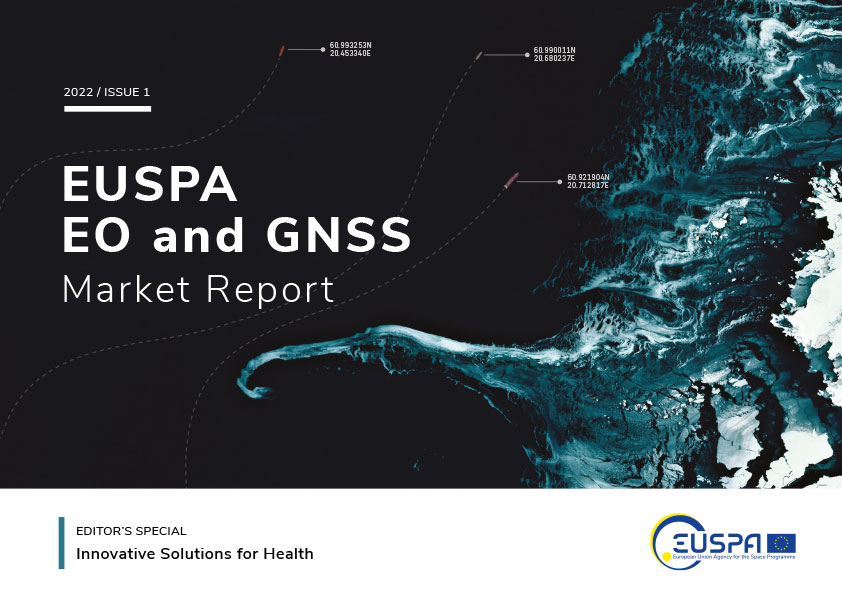
    The European Union Agency for the Space Program (EUSPA) has published “EUSPA EO and GNSS Market Report,” a guide to reaping the benefits of space technology.

    The 216-page report is designed to help anyone who seeks to make EU space technologies part of their business plan, develop new space downstream applications, and see a tangible return on investment.

    More than ever society relies on innovative solutions to deal with the big data paradigm, respond to and mitigate climate change, natural and man-made disasters, curb the spread of diseases and strengthen a global supply chain that underpins our daily lives.

    Download report here.
    Download report here.

    Earth observation and GNSS data is becoming increasingly important to innovative solutions for climate change, disaster and disease response, and global supply chain management. Dozens of applications are emerging or already in use by citizens, businesses, governments, industry, international organizations, NGOs, and researchers around the world.

    The report provides analytical information on the dynamic GNSS and EO markets. In 2021, GNSS and EO downstream markets generated more than €200 billion in revenues and are set to reach almost half a trillion over the next decade.

    The report also offers in-depth analyses of global trends and developments through illustrated examples and use cases. Using advanced econometric models, it also offers market evolution forecasts of GNSS shipments or EO revenues spanning to 2031.

    Green Investments

    EUSPA is committed to helping the EU deliver on the Green Deal agenda and the fight against climate change, starting with embedding space data and services into professional activities. According to EUSPA, accelerating Europe’s engagement in space is pivotal to enabling the green transition and reaching climate neutrality by 2050.

    The report emphasises how users of EO and GNSS contribute to compliance, monitoring and efficiency of green investments, benefiting companies, regulators and society as a whole. It focuses on concrete examples across the 17 identified market segments.

    For instance, Galileo can provide smart power grids with robust timing and synchronization down to a nanosecond, improving their performance. In another example, EU space plays a role in green energy, as Copernicus helps optimize performance of tidal power generators by providing tidal current prediction systems.

    Key Report Findings

    • Global GNSS- and EO-enabled revenues crossed €200 billion in 2021 and are set to reach almost €500 billion over the next decade.
    • The global installed base of GNSS devices in use will reach more than 10 billion units in 2031.
    • The market for Earth observation applications is boosted by a large pool of value-added services (85% of global revenue).
    • The European EO industry is dominated by SMEs and start-ups; from a supply perspective, European companies hold more than 41% of the global EO market.
    • The downstream space application market accompanied by the EU Space Programme will continue growing and thereby effectively contributing to European policies (such as the European Green Deal and EU’s Digital Decade), as well as global policies (such as the United Nation’s Sustainable Development Goals and the Paris Agreement) in combination with other technologies.

    Download the report.

  • 1Spatial unveils new survey capabilities in 1Edit

    1Spatial unveils new survey capabilities in 1Edit

    Screenshot: 1Spatial
    Screenshot: 1Spatial

    1Spatial has extended the capability of its survey application 1Edit, increasing support for photos and 2.5D data.

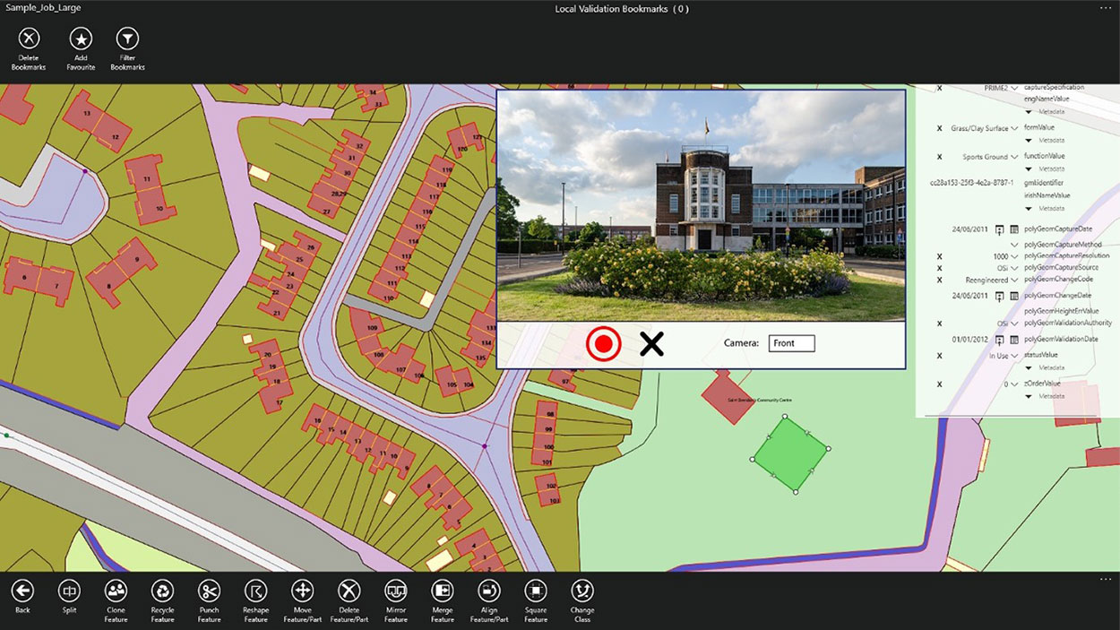
    1Edit 3.1 allows users to attach feature photos, including automated geotagging, which enables surveyors to visualize assets and fine-tune their observations. The latest version now includes new validation functions and improved handling for heights (2.5D data), typically useful for detailed asset and land-management surveys.

    Enhanced styling, including bitmap fills and dashed lines, make it easier to identify and classify different asset types during surveys. Additional control of editable layers and fields provide protection for non-editable data and protects the quality of data. Significant improvements to rendering of thematic mapping further enhances the speed and fluidity of the intuitive user interface.

    1Edit also now supports the storage of photographs as an attribute on a feature. The photos can be captured from the front or rear camera and are stored as a Label object.

    “1Edit’s new survey capabilities further expands our customers’ ability to collect trusted, validated data that is right first time,” said Robert Chell, chief product officer. “By increasing the number of validation options available during a survey, we improve both the quality and accuracy of data, and the effectiveness of survey processes.”


  • Enhanced NAVCEN website coming, new URLs provided

    Enhanced NAVCEN website coming, new URLs provided

    CGSIC logo

    The U.S. Coast Guard Navigation Center (NAVCEN) will transition to a new and enhanced website in the first quarter of this year. The actual transition date has yet to be determined.

    As part of the transition, the URLs will be updated across the site, including URLs linked to PDFs. URLs from the legacy site will no longer work. Any bookmarked URLs or URLs used in automatic downloading of data or products will need to be updated.

    “We have identified the below URLs as essential to your continued business,” reports Rick Hamilton, CGSIC Executive Secretariat, in a . “Please keep in mind, that while we are sending the URLs in advance, they will not be active until we launch the new website. Once the new website goes live, your URLs will be available for re-bookmarking.”

    GPS Almanacs

    Current URLs: https://navcen.uscg.gov/?pageName=gpsAlmanacs

    Replacement: https://www.navcen.uscg.gov/gps-nanus-almanacs-opsadvisories-sof

    GPS NANUs

    Current URLs: https://www.navcen.uscg.gov/?pageName=currentNanus

    Replacement: https://www.navcen.uscg.gov/sites/default/files/gps/nanu/current_nanu.nnu

    GPS Constellation Status

    Current URLs: https://navcen.uscg.gov/?Do=constellationStatus

    Replacement: https://www.navcen.uscg.gov/gps-constellation

    NAVCEN will contact users with a launch date for the new website.

    The NAVCEN team can be reached at its help address.