Blog

  • The surveyor and augmented reality – ready for the future

    The surveyor and augmented reality – ready for the future

    Photo: ipopba/iStock / Getty Images Plus/Getty Images
    Photo: ipopba/iStock / Getty Images Plus/Getty Images

    The surveying profession has experienced a plethora of advancing technology over the past two decades and it does not look like there will be a slowdown any time soon. From robotic total stations to laser scanning to the use of multiple GNSS constellations, the profession is constantly adapting these emerging technologies into a useful tool for daily applications. For most practicing surveyors, it is a challenge to keep up with not just the hardware of these advancements, but also with software, which is being developed in parallel. Have you tried to open and draw a simple figure in any of the industry standard CAD programs lately?

    The complexity of these programs, while advancing the capability of many technical professions, forces even the casual user to maintain a regular habit of software education and training. While it may seem primitive to say that a practitioner is a “practicing” surveyor, on-the-job training never stops. Just when the profession thinks there are no more significant advancements, something comes out of left field that truly blindsides us. (See the adoption of UAVS by the surveying profession compared to the public sector…) What do I think will be one of the next “big things” to revolutionize surveying? The technology is already here, and we need to seriously get on board with adoption before we miss another opportunity to highlight the expertise of the profession.

    VIRTUAL REALITY and AUGMENTED REALITY (VR & AR)

    First, we need to know that virtual reality (VR) and augmented reality (AR) are different, even though many people use these terms interchangeably. The differences are as follows:

    Virtual Reality (VR)

    • VR is a virtual world generated by computers and programming.
    • VR is a closed environment that is fully immersive.
    • VR requires a device (specialized glasses and/or a headset).
    • Users in the VR experience are limited by the programming and their computer’s abilities.
    • The VR experience may be based upon real-world conditions but is a fictional setting.
    • Users of VR can travel and experience conditions in real and fictitious places.
    • VR can allow users to have experiences that are not physically possible in the real world.
    • VR is 75% virtual + 25% real (industry “rule of thumb”)

    Augmented Reality (AR)

    • AR is typically based on actual physical places.
    • AR is an open environment that is partly immersive.
    • In AR, the user controls the environment.
    • AR combines virtual elements and experiences with real world conditions.
    • Experiences in AR can be accessed by computer, tablet, and smartphones.
    • AR is useful for product visualization and evaluation.
    • AR is 75% real + 25% virtual (industry “rule of thumb”)

    It is important to know these difference between the two technologies in order to implement the correct one for the task at hand. However, both will play an important in surveying for generations to come.

    Photo: Georgijevic/iStock / Getty Images Plus/Getty Images
    Photo: Georgijevic/iStock / Getty Images Plus/Getty Images

    USES OF VIRTUAL REALITY TECHNOLOGY FOR SURVEYING

    One of the surveyor’s biggest responsibilities is to complete an accurate site conditions model by topographic methods. Once the topographic survey is completed, site designers will utilize this information to create a unique project that works with the existing site conditions. Advances in CAD software and technology allow engineers and architects to design in 3D and blend the new site with the existing conditions, drainage, and utilities. These designs can be further refined into virtual reality models to give the project’s stakeholders a better indication of what the final product will be when construction is completed.

    The key takeaway here is that the surveyor is responsible for delivering the existing conditions model. A model that accurately represents the subject site but in digital form enables the design of the project to be more efficient and realistic to meet the client’s expectation. Surveyers, however, will not use virtual reality as much as augmented reality, for many good reasons.

    USES OF AUGMENTED REALITY TECHNOLOGY FOR SURVEYING

    AR is still in its infancy. Because surveyors have an interest in the existing and proposed conditions of sites, the use of AR becomes an important tool for the future. Merging proposed information with existing site conditions can become the norm, but like many emerging technologies, the profession will need to learn how to embrace it.

    To get a better idea of how the technology works and why surveyors need to consider using it, let us look at an application that showcases AR: Pokémon Go. Yes, the smartphone game app that took the world by storm in 2016 and captivated many “trainers” to search the streets for Ultra Balls and characters. (There are still more than 100 million active players worldwide.) Players of all ages have continued to search for elusive items and characters in a high-tech scavenger hunt that is constantly changing, and all based upon the real world around us. By merging a real-time view with game entities at random geographic locations, players move about our world using one of the best examples of AR.

    How does this apply to the surveying profession? Surveyors could utilize AR in everyday tasks but that would require having a fully developed 3D design model that could merge with the existing conditions in their visual device. There are a variety of devices for utilizing AR, including smartphones and tablets. Many of the new data collectors running Windows and Android operating systems can also be used for incorporating AR into the field operation. Here are some examples of AR how can be utilized for surveying tasks:

    • While construction staking, AR can be used to assist with structure and improvement location. A quick visual check can help confirm staking calculations are consistent with engineering design.
    • Use AR to visually check installed improvements, including curbs, utility structures, and paving. Any deviation from the proposed design should be quite evident.
    • When establishing property corners, AR will help the field crew quickly determine whether the calculated location is accessible. This can be used for staking out pre-calculated boundary points and/or proposed lot corners in a new subdivision.

    Photo: AnnaFrajtova/iStock / Getty Images Plus/Getty Images
    Photo: AnnaFrajtova/iStock / Getty Images Plus/Getty Images

    Here are a few ideas as to how surveyors could utilize AR in everyday tasks in the future:

    • As public utilities are becoming more available within GIS shape files with geographic locations, they could be utilized with AR to help visually establish locations in the field. Mainline utilities and service lines would become easier to physically verify using AR.
    • Another GIS shapefile entity, the parcel line layer, could be used to help the surveyor understand where the property owner believes the line(s) to be as opposed to the actual monumented location.
    • All reference monuments and benchmarks established by public agencies using geographic location information could enhance the “treasure hunt” of confirming local datum points.

    SURVEYING USING AR TO PROTECT THE PUBLIC

    Geospatial information has revolutionized our world, so using AR to help when trouble strikes can potentially be a lifesaver. Recently, an oceanfront condominium in Florida collapsed due to structural failure. While the age of the structure precluded it from having any digital geographic location data, any new similar development could be measured and recorded to assist with future emergency needs. Almost all new development has digital surveying, engineering, and architecture and must use local horizontal and vertical datums. Using the proposed information and verifying with post-construction record drawings, the digital record can be created.

    It doesn’t take a design flaw to create a public hazard. For instance, a gas leak could render any building, such as the Florida condo, susceptible to catastrophic damage. By having a digital model of the underground structure, emergency crews could use AR to help locate potential open spaces in the building. As is the case with installing fire suppression systems and emergency exits, the cost to create a digital model of a completed building will be well worth it to save lives.

    Underground utility corridors within cities, campuses, or manufacturing facilities could also utilize geospatial locations to establish a digital map for future use with AR. It will take time and significant cost to map existing facilities, yet it should be required for new sites to provide this information for emergencies and for use when designing expansions within the site. Having this utility information to use with AR during the design phase could lead to identifying potential problems before construction starts.

    Photo: 1001nights/E+/Getty Images
    Haiti after an earthquake. (Photo: 1001nights/E+/Getty Images)

    Another reason to plan for future safety is how much uncertainty we face in today’s society. At press time, we are coming up on the 20th anniversary of 9/11. We also just watched Haiti suffer another devastating earthquake. The 2021 hurricane season has also been very active, so that danger looms large, too. Disasters happen all the time with little to no warning. Our world is much more advanced than we were at the turn of the century, so we can use these advancements to map our infrastructure. Let us hope we never need to use the digital information for another disaster akin of 9/11. Instead, let us use it to ensure that we can get to someone in a remote spot if necessary.

    THE ROAD TO FUTURE MAPPING AND AUTOMATION

    As previously discussed, establishing a digital twin of our world could help provide a better map for establishing parcel ownership, reducing construction conflicts, and offering better planning tools for future expansion. Will it be completed within my lifetime? No, and I doubt it will be done within the next couple of generations after me.

    We can, however, get a significant start on capturing the necessary information to begin the process of digitization. Technology has exceeded my expectations just within the past decade, so I can only hope that more advancements will help with building this digital beast. More architects and engineers are utilizing BIM (building information modeling) for 3D design and collaboration. Most municipalities and counties have built some form of GIS that uses one of the standard geographic datums. Surveyors have fully embraced GNSS technology so state plane and national geographic coordinate systems have become the norm. In addition, we are seeing a wide number of consultants use autonomous vehicles (aerial, hydro, and terrestrial) with photogrammetry, LiDAR, and SLAM remote sensing. Another bit of good news is that computing power is higher than ever and that storage space is cheap for all this data. We should also include how 5G has expanded our reach and, with cloud storage, we can work from just about anywhere. We can do so much more than most of us ever dreamed of, so we need to leverage that into creating a digital entity that can be helpful.

    Photo: RyanJLane/E+/Getty Images
    Photo: RyanJLane/E+/Getty Images

    HOW TO IMPLEMENT THE LATEST TECHNOLOGY

    Augmented reality is one of many new technologies surveyors need to introduce into their toolbox. Many of you may be asking where to begin; my answer, depending on your age, may offend you.

    Hire a Gen Zer. Really.

    As a Gen Xer, I have come to realize my limitations on technology and being able to fully implement it. The Z generation, while lacking the experience of us wily old guys, see things much differently. The smartphone/tablet/computer, and even the latest data collectors, are designed with them in mind. They grew up playing computer games based in virtual reality, developed excellent hand-eye coordination, and find efficient ways of getting things done. Our surveying world is almost completely digital (when is the last time a client only wanted paper copies of a plat?), so now is the time to make the leap and ditch the drafting table. We have as much to learn from them as they do from us. Together, we can get the surveying profession ready for the next generations. It has been a great profession for us, so let us hand it off to the Z generation. They will (eventually) be glad we did.

  • US Air Force invests in flying cars

    US Air Force invests in flying cars

    Are ‘”flying cars” unmanned aerial vehicles, manned aircraft, electric aircraft or just regular aircraft? Or perhaps a mix of all of these? Flying cars raise so much interest because of their potential to fulfill the space-age Jetsons promise, with the regular family parking one at their house, then using it to go to work, go grocery shopping and take the kids to school — all the things we do today in cars on roads.

    The U.S. Air Force recognized that flying cars could also revolutionize how it operates, and in 2020 started putting effort and cash into promising commercial flying-car ventures. Since then, the Air Force has begun to make progress. Its AFWERX Agility Prime program has helped four companies — Kitty Hawk Aero, Beta Technologies, Joby Aviation and Lift Aircraft — develop prototype commercial flying-cars and expand their capabilities.

    The Kitty Hawk Aero Heaviside

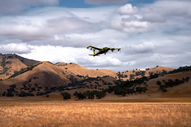
    Kitty Hawk Aero in Palo Alto, California, has been working on its electric vertical take-off and landing (eVtol) aircraft for several years and claims to have proven its tilting propeller concept through several hundred vertical take-off/landing to horizontal flight transitions.

    The aircraft — known as Heaviside — has just been granted airworthiness approval by the Agility Prime program, enabling Kitty Hawk to further participate in specialized trials funded by the Air Force.

    Heaviside takes off vertically. (Photo: Kitty Hawk)
    Heaviside takes off vertically. (Photo: Kitty Hawk)
    Heaviside comes in for a landing. (Photo: Kitty Hawk)
    Heaviside comes in for a landing. (Photo: Kitty Hawk)

    The majority of flight testing flown by Heaviside has been remote without on-board crew (one or two pilots). This has enabled Kitty Hawk to expand the flight envelope without risking lives. For instance, you might assume those initial vertical to horizontal transitions could have carried a degree of risk, even though those switches in flight mode are now considered virtually risk free.

    Nevertheless, the aircraft is also equipped with an on-board parachute recovery system that has been demonstrated to gently lower the aircraft to the ground in the event of a complete electrical failure. The design has minimized weight, even though the aircraft carries sufficient battery power to provide a range of more than 100 miles. A speed of up to 180 mph has been achieved.

    The Beta Technologies Alia

    Another AFWERX participant in the Agility Prime project is also well along in its flight test program. Beta Technologies has been flying its Alia prototypes on routes of more than 100 miles and pushing velocities of 150 mph.

    Alia eVtol aircraft. (Photo: Brian Jenkins/Beta Technologies)
    Alia eVtol aircraft. (Photo: Brian Jenkins/Beta Technologies)

    Alia is large — it’s in the 7,000-pound aircraft category with a 50-foot wingspan. Alia is designed to carry six people over 250-mile routes, with a cargo capacity of 1,500 pounds. It is powered by on-board lithium-ion batteries. The Air Force expressed serious interest in the design and flight-test planning phase before Alia became airborne. The craft has since proven it is capable of safe, reliable flight over routes such as Plattsburg to New York. The Federal Aviation Administration has authorized such flights ahead of time, but Beta also just received additional airworthiness authorization from the Agility Prime office to enable further trials.

    The Air Force clearly has great faith in Beta Technologies. The company received an even greater boost to its Beta eVtol program from the commercial sector. BLADE Urban Air Mobility has already ordered 20 of these electric aircraft, and UPS has also ordered 10, with the expectation that their order could grow to up to 150. UPS can clearly see the time and cost advantage of landing aircraft directly at its package-sorting facilities, then loading and vertically launching Alai onto delivery routes, either manned or autonomously as a cargo UAV. United Therapeutics, which is developing artificial organs for human implantation, is another key sponsor, presumably to find the shortest transit time to client hospitals.

    Amazon also may become involved following Beta’s recent successful $368 million funding round led by Fidelity and Amazon’s Climate Fund, giving the company stratospheric “unicorn” valuation of more than $1 billion. Maybe there could be Amazon package delivery service in Beta’s future.

    The Joby Aviation Craft

    Joby Aviation is another earlier participant in the U.S. Air Force’s Agility Prime program and was granted airworthiness authorization in 2020. Joby first flew a subscale prototype in 2015 and a full-size aircraft in 2017, with the objective of proving the viability of a tilt-rotor, four-passenger flying taxi/eVTOL aircraft.

    Joby eVtol in flight in Northern California. (Photo: Joby Aviation)
    Joby eVTOL in flight in Northern California. (Photo: Joby Aviation)

    Joby’s story may be similar to the other companies developing electric flying cars, save that it has been doing this since 2009. Over time, Joby has won significant funding and support from key industry sponsors including Toyota, Uber, Elevate and Agility Prime. A study by Lufthansa in 2021 touted Joby as the leader in the eVtol competition.

    The FAA has agreed that Joby can proceed down a certification path applying regular general aviation part 23-64 rules, plus special conditions that include special attention for batteries and fly-by-wire controls. Joby is making good progress toward certification objectives, having already flown more than 1,000 times with different prototypes.

    With six tilt-rotors driven by electric motors, Joby’s yet-to-be-named four-passenger aircraft is capable of 200 mph with a +150-mile range, weighs 4,000 pounds and is apparently one of the quietest, measuring only 65 dBA at ~110 yards while hovering. A low noise profile is key to acceptance of these relatively low-altitude flying-cars as they buzz across densely populated areas — and all manufacturers have come up with low-noise-profile designs.

    The Lift Aircraft Hexa

    Lift Aircraft has taken a different path toward introducing flying-car technology into everyday use by borrowing more closely from existing drone capabilities. The company hopes acceptance will be quicker under its adopted FAA’s Powered Ultralight classification (FAR Part 103), which does not require a pilot’s license to fly.

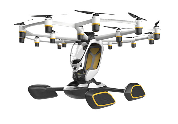
    The Lift approach also intends to take so many precautions and use so much automation that anyone can fly its Hexa. Floats prevent sinking for forced landings on water; triplex flight-computers, GPS and IMUs add to the fail-safe design; and an automatic parachute release in the event of an in-flight incident deploys a “whole-aircraft air bag.” Along with 18 redundant electric-motor-driven propellers (only 12 are needed for a safe landing), these features add up to safety for the uninitiated.

    Hexa single-pilot drone-car. (Photo: Lift)
    Hexa single-pilot drone-car. (Photo: Lift)

    The single joystick control is simple to use and allows the unskilled to fly the drone-car safely. The system comes with extensive monitoring built in, so remote safety operators can intervene in extreme situations. Flight is currently only allowed in geo-referenced airspace defined by Lift. The vehicle has the capability to fly itself out of potentially dangerous situations and avoid mapped obstacle locations. Flight is semi-autonomous and take-off and landings are automated.

    Agility Prime joined with Lift in April 2020 to support the company’s safety testing, and in August 2020, funded expansion of the Hexa flight envelope. The Air Force has loaded a Hexa drone-car into a C-130 transport aircraft and flown it to another location to verify transportability for remote deployments. Lift has also won another contract from the Air Force for autonomous cargo retrieval based on a subset of the Hexa design elements.

    It is possible that many people will see Hexa in operation during a coming demonstration tour planned for major population centers across America – 15,000 people have apparently already signed up to fly Hexa when the tour gets underway, possibly later this year.

    Wrapping It Up

    So are these craft flying cars, or drones carrying people? It’s still hard to say definitively, but for sure many experts believe in the forecast of 160,000 flying taxi-cars by 2050, with airport shuttle and air-taxi markets reaching a market value of $500 billion. Certainly the Agility Prime program seems to have got it right and taken the necessary steps to ensure this technology gets out of its emerging, curio stage and out into a world eager to adopt it. If only we could accelerate the extremely lengthy civilian certification phase while still embedding increasing levels of safety. Perhaps the Air Force program can get us there quicker.

    Tony Murfin
    GNSS Aerospace

  • UAVs speed surveying and construction projects in United Kingdom

    UAVs speed surveying and construction projects in United Kingdom

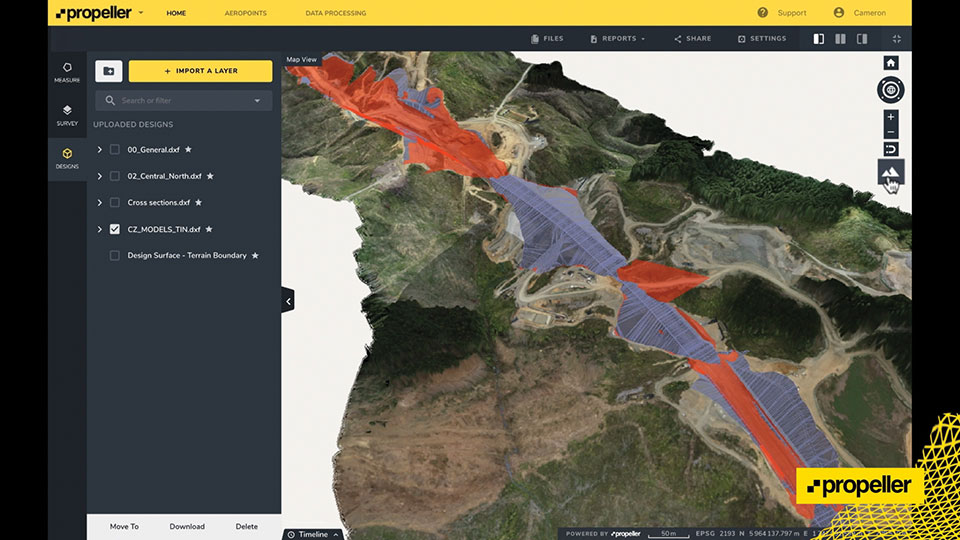
    Screenshot: Propeller
    Screenshot: Propeller

    For a major project, surveying with traditional GPS equipment would normally take many days, Learn how Trimble and Propeller helped speed progress.

    Wills Bros, a family-run contractor based in the UK and Ireland, has begun work on the £29 million (USD $40 million) Maybole Bypass project in Scotland. The 6-km (~ 3.75-mi) project involves 900,000 cubic meters of earth removal and a further 15,000 cubes of rock that needs to be excavated and removed. In addition, Wills Bros is responsible for the construction of 10 culverts to deal with water flow in the area.

    For a project this size, surveying the entire site with traditional, ground-based GPS equipment would normally take six days, estimates Jonathan Wills, who was instrumental in the company’s recent investment in Trimble and Propeller equipment. But considering the increased accuracy tolerance required for some of the structural elements involving the culverts, getting useful survey data from the ground would actually take weeks for this project.

    As an alternative, Wills Bros is using Propeller PPK, a drone surveying workflow that combines DJI’s Phantom 4 RTK drone; AeroPoints’ “smart” ground-control points; offloaded data processing; and the Propeller Platform software that allows measuring of the site using 3D models generated from drone images. Wills Bros also is using Trimble Stratus for cloud-based drone survey processing, visualization and analytics with Propeller Platform.

    Wills Bros was able to collect an initial earthwork takeoff of the Maybole project area in a fraction of the time.

    “Savings on labor costs alone have been considerable given the fact that on so many occasions we can now obtain detailed project data within a second rather than sending a man on site to survey for information,” Wills said. “The drone comes in a backpack and is up in the air doing its thing within minutes. From the outset, the time savings are immense.”

    Once the drone and ground-control data are uploaded, Propeller transforms them into a 3D terrain model that can be measured in the cloud-based Propeller Platform.

  • 61st CGSIC meeting scheduled for Sept. 21

    61st CGSIC meeting scheduled for Sept. 21

    CGSIC logo

    The U.S. Department of Transportation (DOT) and the U.S. Coast Guard Navigation Center (NAVCEN) will hold the 61st meeting of the Civil GPS Service Interface Committee (CGSIC) on Sept. 20-21.

    The meeting will be conducted at the St. Louis Union Station Hotel in St. Louis, Missouri, in conjunction with the Institute of Navigation’s 2021 ION GNSS+ conference.

    The 61st CGSIC meeting will also be broadcast live online to provide a virtual option. This is a unique opportunity for anyone in the world with access to a computer to attend these public meetings of the U.S. Civil GPS program. CGSIC meetings are free and open to the public.

    The three subcommittees of the CGSIC will meet on Sept. 20: Timing; International Information; and Surveying, Mapping, and Geosciences.

    Summaries of the subcommittee meetings will be presented to the CGSIC plenary session Sept. 21 with a keynote address by Juliana Blackwell, director of NOAA’s National Geodetic Survey (NGS).

    The CGSIC agenda in development can be found on the CGSIC section of GPS.gov.

  • Mapitude offers 2021 US ZIP Code business count data

    Image: Mapitude
    Image: Mapitude

    The Maptitude 2021 ZIP Code Business Count data are available now. The update includes the total number of businesses by type (by six-digit North American Industry Classification System or NAIC” codes, formerly known as SIC codes).

    For each business type (for instance, full-service restaurants), users can map the number that fall into each employment size category (for instance, full-service restaurants with 1-4 employees, full-service restaurants with 1000+ employees, etc.).

    These data are useful for businesses and market research analysts because they allow analysis of market potential, measuring the effectiveness of sales and advertising programs, setting sales quotas, and developing budgets. Government agencies use the data for administration and planning.

    The ZIP Code Business Count data are free for Maptitude 2021 users, and is also available as shapefile, KML, KMZ or GeoJSON for a fee.

  • Bluesky National Tree Map shows changing face of Sevenoaks

    Photo: Bluesky
    Photo: Bluesky

    A new map detailing the location, height and canopy for trees more than 3 meters in height is helping Sevenoaks District Council manage its iconic ancient trees and natural woodland.

    Derived from Bluesky’s National Tree Map, which provides geospatial intelligence for more than 300 million trees across the United Kingdom, the data has already been used to create a district-wide map of tree cover, to create 3D visualizations to inform development decisions, and to support planning enforcement investigations.

    Sevenoaks District Council originally purchased National Tree Map data from Bluesky in November 2019, and the data is widely used across the council with specific applications in planning.

    Updated this year, the original and new tree-map layers are stored in the council’s GIS alongside multiple years of aerial photography, Ordnance Survey maps, data such as Ancient Woodland and Biodiversity Opportunities, and council data including Tree Preservation Orders and Planning Applications. The tree data is accessible to all staff via the council’s intranet mapping system GISMO (GIS Online).

    The name Sevenoaks (the name given to the town and more recently to the district) dates to circa 800 A.D. and is thought to be derived from “Seouenaca,” the name given to a small chapel near seven oak trees. Records of these trees through the ages are sparse; it is not until the 19th century when a group of seven trees appears on an Ordnance Survey map.

    The eponymous oak trees have been replaced many times over the years, including the planting of seven oaks to commemorate the coronation of Edward VII in 1902 and tree planting by personnel from the Canadian Air Force in 1947 in gratitude for being billeted in the town.

    Bluesky’s National Tree Map is created using innovative algorithms and image processing techniques in combination with the most up-to-date and detailed aerial photography, terrain and surface height data, and color infrared imagery.

    In addition to the three vector map layers — Crown Polygons, Idealised Crowns and Height Points — the Bluesky National Tree Map also includes an attribute table with unique identification for each crown feature, height attributes and area calculations.

  • Inertial Labs explains lidar, GPS-aided INS and data management

    Inertial Labs explains lidar, GPS-aided INS and data management

    A new blog offered by Inertial Labs discusses the scope of work to turn lidar point-cloud data collection into actionable deliverables. The blog, “Providing Actionable LiDAR Point Cloud Deliverables and the Inertial Labs RESEPI” by Luke Wilson, is also available as a downloadable PDF.

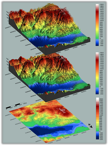
    A digital terrain model, a digital surface model, and a digital elevation model (from top). (Image: Inertial Labs)
    A digital terrain model, a digital surface model, and a digital elevation model (from top). (Image: Inertial Labs)

    The blog introduces lidar and creation of point clouds, then discusses the use of GPS-aided inertial navigation systems (INS). “A lidar point cloud is the product of sensor fusion across a GPS-aided INS and a lidar scanner. Each sensor plays a critical role in how a lidar payload functions and the applicability of its point cloud output,” explains Wilson.

    Wilson describes complications with converting datum reference frames, both traditional and reference ellipsoid such as WGS84. He also discusses projected coordinate systems. He concludes with analysis of the data using point classification — the foundation to create models including digital terrain, surface and elevation models (DTM, DSM and DEM respectively).

    Finally, Wilson explains how Inertial Labs’ RESEPI is a quick and efficient way to generate models of an environment, including in fields such as construction and utility management.

    RESEPI stands for REmote SEnsing Payload Instrument, Inertial Labs’ complete multiplatform, multisensor lidar and RGB payload solution for such remote sensing applications.

    Read the full blog.


  • With SV08, 3 GPS III satellites ready for launch

    With SV08, 3 GPS III satellites ready for launch

    The U.S. Space Force’s Space Systems Command recently declared GPS III SV06, SV07 and SV08 satellites “Available for Launch.” Here, the space vehicles await official call up for launch in Lockheed Martin’s GPS III Processing Facility in Waterton, Colorado. (Photo: Lockheed Martin)
    The U.S. Space Force’s Space Systems Command recently declared GPS III SV06, SV07 and SV08 satellites “Available for Launch.” Here, the space vehicles await official call up for launch in Lockheed Martin’s GPS III Processing Facility in Waterton, Colorado. (Photo: Lockheed Martin)

    The U.S. Space Force’s Space Systems Command has declared the eighth GPS III satellite “Available for Launch.” This milestone marks the third space vehicle within the GPS III program to be declared available for launch in the past three months.

    The next three GPS III satellites — SV06, SV07 and SV08 — are now awaiting official call up for launch in Lockheed Martin’s GPS III Processing Facility in Waterton, Colorado.

    “SV06, SV07, and SV08 AFL milestones in just three months prove that GPS III production continues to benefit from efficiencies with each satellite delivery,” said Col. Edward Byrne, chief of SSC’s Space Production Corps’ Medium Earth Orbit Space Systems Division.

    The first of the three recently completed satellites, SV06, is scheduled to launch in 2022 and will join the operational constellation of 31 GPS satellites.

    GPS III satellites deliver enhanced performance and accuracy through a variety of improvements, including increased signal protection and improved accuracy.

    GPS III also expands the civilian L5 signal, dubbed the “safety-of-life” signal, currently broadcast by the 12 GPS IIF satellites, but not yet operational, and delivers a new L1C signal designed to grant interoperability to similar international space-based position, navigation and timing (PNT) systems around the world.

    As a crucial technological foundation for internet, financial, transportation and agricultural operations, GPS delivers the gold standard in positioning, navigation, and timing services supporting U.S. and allied operations worldwide.

    Space Systems Command, located at Los Angeles Air Force Base in El Segundo, California, is the U.S. Space Force’s Center of Excellence for acquiring and developing military space systems. SSC’s portfolio includes space launch, global positioning systems, military satellite communications, a defense meteorological satellite control network, range systems, space-based infrared systems, and space domain awareness capabilities.

  • BAE Systems unveils tiny M-code military GPS receiver

    BAE Systems unveils tiny M-code military GPS receiver

    Photo: U.S. Army/Spc. Brooke Davis, Operations Group, National Training Center
    Photo: U.S. Army/Spc. Brooke Davis, Operations Group, National Training Center

    BAE Systems has unveiled its ultra-small MicroGRAM-M GPS receiver that receives the new M-code military GPS signals resistant to jamming and spoofing.

    About the size of a postage stamp, MicroGRAM-M is a small, lightweight and power-efficient M-code embedded GPS receiver, capable of delivering assured positioning, navigation and timing (PNT) for size-constrained and other micro-applications.

    “We’re delivering reliable PNT where our customers need it — from soldiers’ handheld devices to small unmanned aerial vehicles,” said Greg Wild, director of Navigation and Sensor Systems at BAE Systems. “MicroGRAM-M provides our armed forces and allies with a low-SWAP M-code GPS solution that’s resistant to adversaries’ disruption efforts in highly contested environments.”

    MicroGRAM-M features rapid, secure GPS signal acquisition, enhanced security and resiliency, anti-jamming and anti-spoofing capabilities, and very low power consumption for an M-code device. The 1.0 x 1.25 x 0.275-inch MicroGRAM-M has the same physical dimensions as its predecessor, enabling quick upgradability to M-code and reduced system integration costs. At its core is a proven, tamper-proof M-code Common GPS Module that encapsulates classified data and signal processing.

    “MicroGRAM-M is the latest BAE Systems M-code military GPS product, joining MPE-M and NavStrike-M, which deliver enhanced awareness in highly contested environments and precision munitions guidance,” said John Watkins, vice president and general manager of Precision Strike & Sensing Solutions at BAE Systems. “Qualification of MicroGRAM-M is underway, with full-rate production expected in 2022.”

    Delivering M-code User Equipment to Germany

    On June 29, BAE Systems received the first contract from the Space and Missile Systems Center’s Space Production Corps to deliver M-code military GPS user equipment to Germany. Under a Foreign Military Sales contract, the company is delivering the advanced M-code GPS technology to Germany, enabling precise, resilient, and secure geolocation and positioning capabilities that improve the effectiveness of allied operations.

    The German FMS order focuses on BAE Systems’ Miniature PLGR Engine — M-code (MPE-M), which delivers precise positioning, navigation and timing capabilities; anti-jamming and anti-spoofing capabilities; a modern security architecture; and a size suitable for space-constrained applications.

    BAE Systems will provide the first MPE-M receivers to Germany for integration, test and evaluation in 2021. Work on the program will be performed at BAE Systems’ facilities in Cedar Rapids and Coralville, Iowa.

  • DroneShield releases GNSS compass for harsh environments

    DroneShield releases GNSS compass for harsh environments

    Photo: DroneShield
    Photo: DroneShield

    DroneShield Ltd. has released CompassOne, a self-contained navigation solution for fixed site, vehicle and marine applications.

    The device provides real-time military-grade location, orientation and direction sensing for deployed static and on-the-go assets. The device can be used both in counter UAS systems and general situations requiring satellite navigation.

    The CompassOne receives:

    GPS L1CA/L1P/L1C/L2P/L2C/L5
    GLONASS G1/G2/G3, P1/P2
    BeiDou B1i/B2i/B3i/B10C/B2A/B2B/ACEBOC
    Galileo E1BC/E5a/E5b/E6BC/ALTBOC
    QZSS L1CA/L2C/L5/L1C/LEX
    IRNSS L5
    Atlas

    With a strong focus on durability and ruggedness, CompassOne is suitable for installation and operation in harsh environments. Military-grade (MIL-SPEC) connectors and high-end stainless-steel hardware ensure uninterrupted connection and protection from the elements, while the aluminium underside provides exceptional impact resistance and rigidity while keeping overall weight low.

    CompassOne can operate stand alone or integrate with DroneShield’s DroneSentry system. Power over Ethernet reduces cable clutter and VESA compatibility makes CompassOne easy to integrate into new or existing systems. Installation is clear and fast with status LEDs, installation graphics and tool-less fasteners.

    “CompassOne, with its ruggedness and incorporation of advanced technologies, integrates seamlessly within DroneShield’s product ecosystem, and equally with third party systems as a stand-alone product,” said Oleg Vornik, DroneShield CEO. “Its accurate navigation is substantially superior to other systems on the market globally.”

    The product is expected to be of interest to both counterdrone and other customers requiring a rugged navigation solution.

  • Indiana city increases citizen engagement with user-friendly GIS program

    Image: Geographical Technologies Group
    Image: Geographical Technologies Group

    In 2019, the City of Hobart Sanitary and Stormwater District (HSD) in Hobart, Indiana, recognized the benefits of geospatial technology and location intelligence to transform the city. HSD reached out to Geographic Technologies Group (GTG) to write and implement a geographic information system (GIS) strategic plan.

    GTG is one of the world’s leading local government GIS companies, working to advance the science of location intelligence and geospatial technology. GTG built a GIS strategic plan for HSD using high-resolution aerial imagery from Nearmap to help build on the city’s need to deliver geospatial data to customers.

    “Our content integrates easily with GTG’s applications and acts as a valuable component to their strategic planning services,” said Karl Terrey, director, Global Alliances at Nearmap. “Our imagery is refreshed multiple times per year and when combined with GTG’s technology allows governments to make decisions based on conditions in their communities in near-real-time.”

    Image: Geographical Technologies Group
    Image: Geographical Technologies Group

    Before GTG, HSD was maintaining a GIS viewer web app that was not user friendly, and thus underutilized.

    HSD leaders recognized the need for an interface that would serve the district as well as other city departments while being easy to navigate. Nearmap’s technology corrected this, by equipping users with controls that were customized to address all the needs of its users.

    Image: Geographical Technologies Group
    Image: Geographical Technologies Group

    “Our goal has always been to solve problems, and introduce a new kind of decision support for our clients,” said James Kelt, VP of Corporate Software at GTG. “Our clients love the imagery and the more we worked with Nearmap, the more we’ve been able to provide this added value to our customers.”

    With the help of the user-friendly ArcGIS Hub, where citizens could access GIS tools, and GTG’s new program, the city of Hobart gained greater citizen engagement that allowed them to find information for themselves. 

  • Orolia adds new GNSS simulator to BroadSim product line

    Orolia adds new GNSS simulator to BroadSim product line

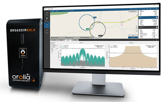
    BroadSim Solo provides advanced GNSS scenario creation on the engineer’s desktop

    Orolia Defense & Security released the latest addition to its GNSS simulator family — BroadSim Solo — at the Institute of Navigation Joint Navigation Conference (JNC) taking place this week in Covington, Kentucky.

    The Solo joins the BroadSim line of Skydel-powered GNSS simulators, which includes models suited for hardware-in-the-loop and multi-element antenna/controlled reception pattern antenna (CRPA) testing.

    Live demonstrations of BroadSim Solo are taking place in the JNC Exhibit Hall at Orolia Defense & Security booth No. 117 through Aug. 26. Orolia provides M-code solutions for resilient positioning, navigation and timing.

    BroadSim Solo shares the same Skydel simulation engine that runs on a standard BroadSim, BroadSim Anechoic and BroadSim Wavefront. It supports advanced scenario creation features and the benefits provided by a software-defined architecture such as high dynamics, a 1000-Hz iteration update rate and ultra-low latency of 5 ms.

    Photo: Orolia
    Photo: Orolia

    Nearly all civilian GNSS signals can be generated through the Solo’s single RF output (one frequency band at a time), along with jamming or spoofing signals, and GPS AES M-code. AES is an encryption method; rather than using the MNSA encryption, it is possible to use AES for testing purposes only.

    BroadSim Solo’s compact form factor is designed to do away with bulk, fitting comfortably at a typical desk or workstation. Plus, the Solo addresses the permanent challenge engineers face with laboratory capacity and availability.

    “Creating complex test scenarios can be a tedious process, especially when emulating challenged environments,” said Tim Erbes, director of engineering for Orolia Defense & Security. “Having the ability to create scripts at your desk significantly frees up lab time and space for running these important simulations. Also, scenario creation is no longer limited to one person fixed to one system. Imagine a team of engineers, each with a BroadSim Solo, simultaneously building tests. Having a whole fleet of BroadSim Solos? It’s game-changing.”

    BroadSim Solo with the Skydel simulation engine offers an intuitive user interface, a comprehensive API supporting Python, C++ and C#, and automation tools and custom plugins that will speed up development cycles, increase performance and ultimately drive innovation.

    “In an effort to enhance the customer experience and expand the reach of advanced GNSS simulators, we wanted to offer an affordable solution with all of the same core features as our most advanced BroadSim systems,” said Tyler Hohman, director of products for Orolia Defense & Security. “This gives our customers the opportunity to place more simulators in the hands of engineers and scientists without sacrificing capabilities. Our hope is that customers will find value in having a simulation ecosystem that is scalable based on their requirements.”

    Photo: Orolia
    Photo: Orolia