Blog

  • 2021 Defense Act signals turning point for Congress and PNT

    2021 Defense Act signals turning point for Congress and PNT

    Senate poised to join House this week and override Trump’s veto

    The U. S. Congress, especially the Armed Services Committees, have long been concerned about GPS and positioning, navigation, and timing (PNT) issues. Over the last two decades Congressional hearings, demands for reports, and investigations have dealt with acquisition, contingency plans for when space is not available, deliberate interference, and a host of other issues.

    While these all evidenced Congress’ interest and concern, they were relatively passive measures.


    The NDAA for 2021 seems to finalize Congress’ transition from an interested observer, mostly on the sidelines, to an active player in national PNT issues and policy.


    This began to change in 2018 with passage of the National Timing Resilience and Security Act. It requires the Department of Transportation to establish a terrestrial timing system to backup GPS signals.

    Then in 2019, Congress appropriated money for a GPS Backup Technology Demonstration. And the National Defense Authorization Act (NDAA) for 2020 required the Air Force to develop a prototype multi-GNSS receiver as part of its resiliency efforts.

    The NDAA for 2021 seems to finalize Congress’ transition from an interested observer, mostly on the sidelines, to an active player in national PNT issues and policy.

    Capitol Hill observers say this is the result of several things that have come to a head over the last year. Taken together, they have convinced many legislators that GPS is under threat and PNT issues are not being taken seriously enough by the executive branch. These include increased jamming and spoofing (especially by China and Russia), full implementation of China’s BeiDou system and its marketing to other nations as a superior alternative to GPS, the Federal Communications Commission’s (FCC) decision on Ligado Networks, and the Pentagon’s failure to respond to combatant commanders’ Joint Urgent Operational Needs Statements for non-GPS PNT.

    Photo: Andrea Izzotti/Shutterstock.com
    Photo: Andrea Izzotti/Shutterstock.com

    Here are some of the provisions of the 2021 NDAA of interest to the PNT community.

    Military Multi-GNSS Receiver Prototype

    The 2018 NDAA required the Defense Department to incorporate Europe’s Galileo and Japan’s QZSS satellite navigation signals into military user equipment. The idea was to make it more resilient to disruption. Also required was an investigation into using non-allied signals.

    Apparently not satisfied with progress on this project, Congress mandated a project to develop a prototype multi-GNSS receiver as part of the 2020 NDAA.

    The 2021 NDAA seems to indicate the Congress is still not happy. It withholds 20% of the funding for the Office of the Secretary of the Air Force until such time as the department certifies the prototype project is underway and provides briefings to the Senate and House Armed Services Committees.

    Resilient Survivable PNT

    Language in the 2021 NDAA also seems to show Congress is impatient with the Pentagon’s lack of responsiveness to combatant commanders’ requests for non-GPS PNT systems.

    Section 1611 of the Act is entitled “Resilient and Survivable Positioning, Navigation, and Timing Capabilities.” It requires development, integration, and deployment of these capabilities for combatant commanders within two years. This, it says, is “… consistent with the timescale applicable to joint urgent operational needs statements…”

    The act says the new PNT capabilities shall “generate resilient and survivable alternative positioning, navigation, and timing signals” and “process resilient survivable data provided by signals of opportunity and on-board sensor systems.”

    The act also reverses the Defense Department’s 2018 PNT Strategy’s plan for future systems to be classified and for military use only. It directs the department to work with the National Security Council, Departments of Transportation, Homeland Security and others “to enable civilian and commercial adoption of technologies and capabilities for resilient and survivable alternative positioning, navigation, and timing capabilities to complement the global positioning system.”

    To help ensure prompt action on this, the act requires a report to Congress within six months and authorizes the department to reprogram funds from other areas to finance the effort.

    Responding to FCC’s Decision on Ligado Networks

    By far the most PNT-related text in the 2021 NDAA includes a host of measures responding to FCC Order 20-48 approving an application by Ligado Networks. An order which the executive branch is on record as strongly opposing saying it will degrade GPS service for many.

    Senator Jim Inhofe, chair of the Senate Armed Services Committee, has regularly expressed outrage at the FCC’s decision and has called for its reversal.

    Among its provisions the act:

    • Requires the Department of Defense to estimate and report to Congress the cost of damage to department systems as a result of the FCC order.
    • Prohibits using department funds to upgrade or modify military equipment to make it resilient to interference caused by broadcasts in the spectrum allocated (the FCC order requires this to be funded by Ligado)
    • Prohibits contracting with any entity using the frequency bands allocated to Ligado unless the Secretary of Defense certifies the use will not interfere with GPS services
    • Requires the Secretary of Defense to contract with the National Academies of Sciences, Engineering, and Medicine for an independent technical review of the FCC order.
  • GPS key to monitoring Kilauea eruption, lava lake

    GPS key to monitoring Kilauea eruption, lava lake

    2020 Ends with a Bang as Kilauea Volcano Erupts

    Beginning in September, GPS stations in Kilauea’s upper East Rift Zone observed increased rates of uplift, higher than they have been since the end of the eruption in 2018. According to the U.S. Geological Survey’s Hawaiian Volcano Observatory, earthquake rates increased in late November.

    On Dec. 2, GPS stations and tiltmeters recorded a ground deformation quake at Kilauea’s summit accompanied by earthquake swarms.

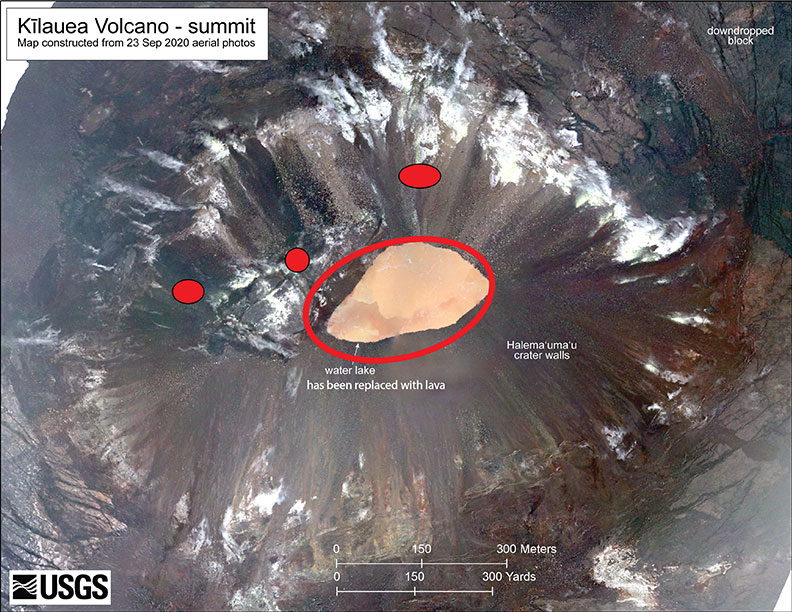
    Then on Sunday, Dec. 20, a magnitude 4.4 earthquake struck on Kilauea’s south flank and three fissure vents broke open inside the caldera. Fountaining lava at these vents is estimated to be up to 82 feet high. The vents are feeding lava flows into the base of Halema‘uma‘u crater, which is being filled with lava. The lava lake has been rising several yards an hour since the eruption began at 9:36 p.m. Sunday. The eruption is currently confined to the crater.

    According to the observatory, “The water lake at the summit of KIlauea has boiled away and an effusive eruption has commenced, with three vents in the wall of Halema‘uma‘u crater generating lava flows that are contributing to a growing lava lake at the base of the crater.”

    As of Dec. 29, the summit eruption continued with the western vent active (the other vents have been covered by the lava lake). At 3:45 a.m. HST, field crews measured the lava lake as 179 meters (587 feet) deep, about 650 feet below the rim.

    Shortly after 9:30 p.m. HST Dec. 20, an eruption began at the summit of Kīlauea Volcano in Hawaii. Red spots indicate fissure vents feeding lava into the bottom of Halema‘uma‘u crater. Lava coverage is 32 feet higher than the water in this photo (base map is from imagery collected on Sept. 23, 2020).
    Shortly after 9:30 p.m. HST Dec. 20, an eruption began at the summit of Kīlauea Volcano in Hawaii. Red spots indicate fissure vents feeding lava into the bottom of Halema‘uma‘u crater. Lava coverage is 32 feet higher than the water in this photo (base map is from imagery collected on Sept. 23, 2020).
    The water lake at the base of Halema‘uma‘u crater has been replaced with a growing lava lake. View from the west rim of Kīlauea Caldera just before 5 a.m. HST on Dec. 21, 2020. A 59-foot fountain joins two other fissures to feed a growing lava lake at the base of Halema‘uma‘u crater. (Photo: USGS)
    The water lake at the base of Halema‘uma‘u crater has been replaced with a growing lava lake. View from the west rim of Kīlauea Caldera just before 5 a.m. HST on Dec. 21, 2020. A 59-foot fountain joins two other fissures to feed a growing lava lake at the base of Halema‘uma‘u crater. (Photo: USGS)
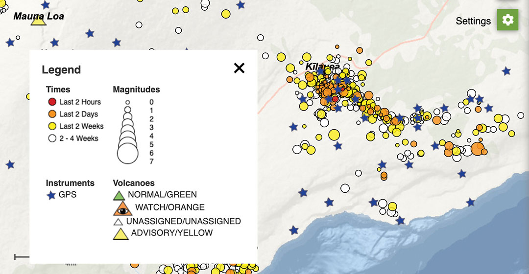
    The interactive USGS monitoring map shows GPS stations situated on and around Kilauea as well as volcano activity. (screenshot taken at 12 p.m. HST on Dec. 21).
    The interactive USGS monitoring map shows GPS stations situated on and around Kilauea as well as volcano activity. (screenshot taken at 12 p.m. HST on Dec. 21).
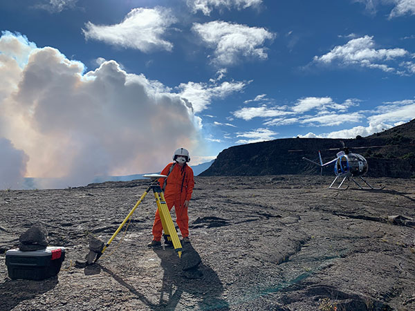
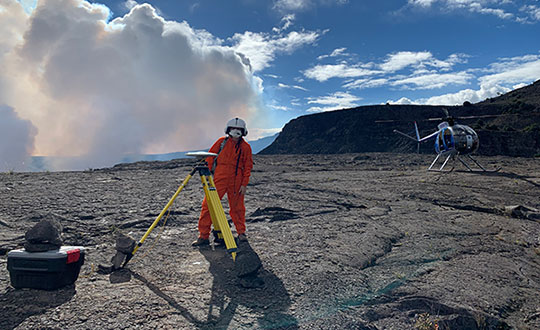
    An HVO geophysicist deploys a GPS receiver on the Kilauea caldera floor to measure changes in ground motion. A volcanic gas plume rises in the background. (Photo: USGS)
    An HVO geophysicist deploys a GPS receiver on the Kilauea caldera floor to measure changes in ground motion. A volcanic gas plume rises in the background. GPS and tiltmeter data show contraction in the upper portion of the East Rift Zone (an area between Kīlauea’s summit and Pu‘u ‘Ō‘ō). (Photo: USGS)
  • Bluesky launches international MetroVista city mapping service at Intergeo 2019

    Bluesky International launched its international MetroVisa city mapping service for Europe at Intergeo 2019, which took place Sept. 17-19 in Stuttgart, Germany.

  • MediaTek’s newest 5G chipset ready for mass-market 5G phones

    MediaTek’s newest 5G chipset ready for mass-market 5G phones

    Photo: MediaTek
    Photo: MediaTek

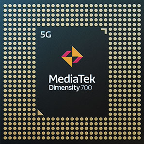
    MediaTek’s Dimensity 700 5G smartphone chipset is a system on chip (SoC) designed to bring advanced 5G capabilities and experiences to the mass market.

    The Dimensity 700 joins MediaTek’s Dimensity family of 5G chips, which is designed to give device makers a suite of options for 5G smartphone models. The chips range from flagship and premium to mid-range and mass market devices to make 5G more accessible for consumers everywhere.

    GNSS signals received include GPS L1CA and L5, BeiDou B1I and B2, GLONASS L1OF, Galileo E1 and E5, QZSS L1C and L5, and NavIC.

    “With our expanded Dimensity portfolio, we’re bringing the latest 5G capabilities to every smartphone tier so more people can enjoy 5G experiences,” said JC Hsu, corporate vice president and general manager of MediaTek’s Wireless Communications business unit. “The Dimensity 700 has an impressive mix of 5G connectivity features, advanced camera capabilities like night-shot enhancements, and multiple voice assistant support, all in a super power-efficient design.”

    Advanced connectivity features include 5G carrier aggregation (2CC 5G-CA) and 5G dual-SIM dual-standby (DSDS), giving users access to the fastest speeds and 5G-exclusive Voice over New Radio (VoNR) services from either connection, the company said.

    On the processing power side, the chip integrates two Arm Cortex-A76 big cores in its octa-core CPU and operates at up to 2.2GHz.

    MediaTek’s Dimensity 5G family of chips are designed for 5G devices across all tiers, and with the Dimensity 700 5G devices will now be accessible to even more consumers.

    For full specifications and further details on MediaTek’s Dimensity 700 series and 5G portfolio are on the MediaTek website.

  • Leica Geosystems launches one app for terrestrial laser scanning portfolio

    Photo: Leica Geosystems
    Photo: Leica Geosystems

    Leica Geosystems has extended its Leica Cyclone FIELD 360 mobile-device app to all Leica Geosystems 3D terrestrial laser scanners for in-field data acquisition and visualization.

    With the push of a button from the mobile-device app, all Leica Geosystems’ laser scanner users can capture high-quality data and verify registration directly in the field, Leica said.

    The Leica ScanStation P-Series, Leica’s survey-grade 3D laser scanners, can now benefit from the existing workflow of the Cyclone FIELD 360 mobile-device app. With the integrated Cyclone FIELD 360 mobile-device app, users can capture and document projects quickly and accurately, view all field workflows, quality control and prepare scan data for downstream use, Leica added.

    “Integrating the ScanStation P-Series laser scanners into the Cyclone FIELD 360 mobile-device app workflow adds in-field visualisation and dataflow benefits, directly linking in-field projects to the Cyclone ecosystem,” said Gerhard Walter, senior product manager at Leica Geosystems. “Customers who own our entire laser scanning portfolio will find it much easier to combine their scan data and not have to buy more equipment as the app can be used on their chosen mobile device to operate the scanners.”

    Leica Geosystems, part of Hexagon, provides scene capture solutions for public safety applications.

  • ION changes date for 2021 Joint Navigation Conference

    ION changes date for 2021 Joint Navigation Conference

    Logo: ION JNC

    The Institute of Navigation (ION) has changed the dates for the 2021 Joint Navigation Conference (JNC) to Aug. 24-27 at the Northern Kentucky Convention Center in Covington, Kentucky.

    The conference will be hosted by the Military Division of the Institute of Navigation for the Department of Defense and Department of Homeland Security. Its theme will be “Enhancing Dominance and Resilience for Warfighting and Homeland Security PNT.”

    The FEDCON U.S.-only sessions will take place at the Northern Kentucky Convention Center in Covington, Kentucky, Aug. 24-26; and the U.S.-only secret sessions will be held at the Air Force Institute of Technology, WPAFB in Dayton, Ohio, Aug. 27. The JNC 2021 exhibit hall will be open Aug. 25-26.

    This decision to change the date and host the conference in person was made in consideration of the forecasted Spring 2021 global accessibility of the COVID-19 vaccine.

    “We have made this decision to ensure our attendees feel safe gathering at ION events,” said Lisa Beaty, executive director at ION. “There appears to be good reason for optimism that our military PNT community will be able to gather again soon.”

    According to ION, JNC is the largest U.S. military positioning, navigation and timing (PNT) conference of the year with joint service and government participation. The event focuses on technical advances in PNT with emphasis on joint development, test and support of affordable PNT systems, logistics and integration.

  • GEO Business 2021 moved to the fall

    GEO Business 2021 moved to the fall

    Logo: GEO Business 2021

    Diversified Communications, organizer of the GEO Business 2021 event, announced that the show will be moved from May 19-20 to Nov. 24-25. It will still take place at ExCel London.

    GEO Business connects the data holders and processors with the people who benefit from the applications and insight, which geospatial information provides.

    “Although all the signs are positive for a restart for large scale events from Easter, we feel May could be a little early to give everyone the best possible chance for a great show,” said Diversified Communications. “So after consulting with the geospatial community, we’ve made the tough decision to push GEO Business back to the autumn for one year.”

    GEO Business will give attendees the opportunity to explore the latest geospatial technology, learn from industry experts, try technology before they it buy, grow their professional work and boost their careers, organizers added.

  • Santa Claus to fly by the International Space Station

    Santa Claus to fly by the International Space Station

    Santa Claus will be performing a ceremonial fly-by of the International Space Station (ISS) on Dec. 24. The visit will honor the 20th anniversary of continuous life on the ISS, a milestone achieved in November.

    The official NORAD Santa Tracker at NoradSanta.org will allow users to track Santa’s journey all day on Dec. 24. New for this year, visitors will be able to see the ISS orbiting the planet in its precise real-time location by zooming out on the 3D Santa Tracker app. Other updates include additions to Santa’s traditional garb, including a face mask and space helmet.

    Santa's sleigh flying past the International Space Station on a precise digital twin of the Earth built by Cesium. (Photo: Cesium)
    Santa’s sleigh flying past the International Space Station on a precise digital twin of the Earth built by Cesium. (Photo: Cesium)

    “The ISS is a spectacular example of what humans can accomplish when we work together,” said Hannah Pinkos, lead developer of the app. “2020 has been a tough year, but I think this special trip is Santa’s way of reminding us to believe in ourselves.”

    NORAD, the North American Aerospace Defense Command, is a United States and Canada bi-national organization that defends North America by tracking objects flying in and around its airspace 24 hours a day using radar, satellites and fighter jets. Each year, it joins corporate partners in taking on a special mission to also track Santa’s sleigh. The app shows Santa’s position reflected on a digital twin of the Earth provided by Cesium, a Philadelphia-based geospatial software company.

    “Cesium is rooted in aerospace, so it’s especially meaningful to us that our technology will allow millions of people to enjoy this event in real-time from the safety of their homes,” added Cesium CEO Patrick Cozzi.

  • UAV updates: Overcoming a navigation challenge, autonomous UAS rolls out

    UAV updates: Overcoming a navigation challenge, autonomous UAS rolls out

    The Boeing B-777 or “Triple-7” is a big airplane — at over 200 feet long, with a wingspan of more than 200 feet, it carries more than 300 people. But getting it from one airport to its destination, which could be up to 8,500 nautical miles away, presents a significant navigation challenge. Combined Air Data and Inertial Reference Unit(s) (ADIRU) and three GPS L1 receivers form the certified primary navigation sensor cluster for the B-777-200.

    Boeing has been undertaking its ecoDemonstraor program using various models of its aircraft, and in 2019 a B-777-200 was available for a number of technology demonstrations.

    Along with the basic objective of testing out new fuel efficient technologies, Collins Aerospace collaborated with Boeing to demo and test their new generation navigation system using dual frequency, multi-constellation GNSS receivers.

    Boeing B-777-200 ecoDemonstrator (Photo: Boeing)
    Boeing B-777-200 ecoDemonstrator (Photo: Boeing)

    The aircraft is normally equipped with buyer selected, certified GPS receivers which also track world-wide Satellite Based Augmentation System (SBAS) signals — not only improving accuracy but also improving (or reducing) the size of integrity bounds of the position solution. Currently, GPS/SBAS L1 is the only signal permitted under current FAA approved MOPS (Minimum Operational Performance Standards) for aircraft use in the US, but new MOPS standards are under development for the use of DFMC. Hence, this demonstration program would significantly aid towards validation of the new MOPS standards.

    For the demo program, the Collins Aerospace GLU-2100 Dual-Frequency Multi-Constellation (DFMC) enabled multi-mode receiver (MMR) was used as the primary position source. The three GLU-2100 MMRs fitted were loaded with modified software that enabled the tracking and use of GPS L1/L5 and Galileo E1/E5a for the navigation solution using multi-frequency GNSS antennas.

    The navigation mode and position integrity algorithms were also revised so the DFMC navigation outputs could be used as the primary navigation outputs for the Flight Management System and the transponder. The Collins GLU-2100 certified L1 position solution was computed in parallel and used to bound the integrity of the Collins DFMC position solution.

    The demo gathered stacks of data on this first use of a DFMC receiver as the primary position source on a civil air transport aircraft. The lessons learned will undoubtable support the effort towards the introduction of dual frequency multi constellation GNSS for regular use in civil aviation.

    Meanwhile, in the world of unmanned aircraft, several thing of note were recently reported, including:

    • Aveum Inc. rolled out its Ravn-X autonomous UAS, which is claimed to be a large, fully autonomous unmanned vehicle which can deliver satellites to low earth orbit.
    • General Atomics demonstrated its Avenger UAV with autonomous CODE (Collaborative Operations in Denied Environment) capability and completed static load testing of the MQ-9B SkyGuardian wing, part of the regular qualification program for civilian aircraft certification.
    • Airbus Zephyr High Altitude Platform Station (HAPS) UAV completed another phase of high-altitude flight testing in Arizona.

    The Ravn-X is a large UAV which apparently uses regular jet fuel, yet claims to be able to get to low-orbital altitudes. With a 60-foot wingspan, 80-f00t length and up to 55,000-pound take-off weight, this is certainly a large vehicle.

    There looks to be a long tubular belly protrusion which could be a rocket motor, or fuel tank, or even a payload bay — absent any explanation of how regular air-breathing engines could reach space, we’ll have to speculate — maybe a new type of engine? Nevertheless, burning jet fuel alone, gaining space access might be difficult. Apparently the US Space Force is a sponsor and future customer, so there should be credibility to these claims.

    Ravn-X new-gen space UAV (Photo: Aveum release)
    Ravn-X new-gen space UAV (Photo: Aveum)
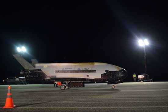
    X-37B U.S. Spaceplane (Photo: U.S. Air Force)
    X-37B U.S. Spaceplane (Photo: U.S. Air Force)

    The object is to provide rapid access to space for small payloads with a reusable, autonomous, unmanned vehicle. The current vehicle is apparently 60% re-usable, soon to become up to 95%. And minimizing turn-round time is also a major target, with a claim of 3 hours being possible — quite an achievement. Of course, the U.S. already has the X-37B Orbital Test Vehicle spaceplane in operation, with a record 780 day stay in space already under its belt.

    During the recent two-hour test flight of the General Atomics Aeronautical Systems Inc. (GA-ASI) Avenger UAV, equipped with tactical radio/data links and targeting capability, independence between control and mission systems was demonstrated.

    The flight also tested a degree of autonomy related to the U.S. Air Force Skyborg (aircraft-UAV teaming) program. The USAF Collaborative Operations in Denied Environment (CODE) software controlled the flight for over two hours without regular ground operator inputs, and coordinated air-to-air search operations with one actual and 5 simulated aircraft.

    GA-ASI Avenger UAS (Photo: GA-ASI)
    GA-ASI Avenger UAS (Photo: GA-ASI)

    The Airbus Zephyr High Altitude Platform Station (HAPS) successfully completed another series of flight tests in Arizona in the first weeks of November. The UAV has undergone weight reductions and was equipped with revised control software which improved system robustness. The UAV is powered solely by sunlight, operates in the stratosphere and provides persistent services currently provided by satellite.

    Zephyr is prepared for flight-test (Photo: Airbus)
    Zephyr is prepared for flight-test (Photo: Airbus)

    Operational flexibility and aircraft maneuverability were demonstrated, particularly during lower altitude flying and during transition into the stratosphere. A new flight planning tool suite was put through its paces and a number of different operational concepts were tested by conducting many flights in quick succession.

    These tests again demonstrated Zephyr’s capability for take-off, climb, cruise, the performance of the upgraded flight control system, descent and successful landing. Day and night on-station performance of almost 26 days was previously demonstrated during July 2018 flight tests.

    It’s good to see demonstrated progress towards dual frequency GPS/Galileo civil aircraft operations through the Boeing ecoDemonstrator program, along with UAV initiatives in potential space-launch capability, autonomous aircraft-UAV teaming, and advances in the HAPS concept. All this, even with the work managed despite these interminable COVID-19 restrictions.

  • Seen & Heard: Sky show, seal solution

    Seen & Heard: Sky show, seal solution

    “Seen & Heard” is a monthly feature of GPS World magazine, traveling the world to capture interesting and unusual news stories involving the GNSS/PNT industry.


    The 10-minute-long drone show included a flying dove with a wingspan of 600 meters, visible from three kilometers away. (Photo: u-blox)
    The 10-minute-long drone show included a flying dove with a wingspan of 600 meters, visible from three kilometers away. (Photo: u-blox)

    A swarm of bird

    A massive swarm of drones created a 10-minute show over Saint Petersburg, Russia, on Sept. 3. The 2,198 miniature UAVs danced for 10 minutes, forming images such as a dove with a wingspan of 600 meters, visible from three kilometers away. Geoscan built and programmed the drones, which use u-blox positioning modules.


    Photo: Danielrao/iStock/Getty Images Plus/Getty Images
    Photo: Danielrao/iStock/Getty Images Plus/Getty Images

    Not bogged down

    Mobile GIS Services (MGISS) is helping the Yorkshire Wildlife Trust (YWT) deploy rugged handhelds to capture highly accurate survey measurements with cloud-based data storage and GIS software. Trust projects include restoring the largest, continuous blanket bog system in England. Blanket bog has been damaged by excessive burning, overgrazing, man-made drainage and extreme weather events. The YWT is using Spectra SP20 handheld GNSS receivers.


    Photo: Genni Brookshire/Ceto Marine Research
    Photo: Genni Brookshire/Ceto Marine Research

    Drones to the rescue

    Seals and sea turtles face threats from humans, such as fishing nets. Marine biologist Genni Brookshire, Ceto Marine Research, and David Thirtyacre, Embry-Riddle Aeronautical University, are researching how drones can improve animal rescue, with help from Skyward, a Verizon Company. Her team is using drones to find and help distressed marine animals. “Using a drone before we respond to an animal to determine the animal’s condition — if it’s entangled, its body condition, if it’s sick — allows us to bring the proper equipment,” Brookshire said. “Using a drone allows us to reduce the stress on the animal, and increase our efficiency in responding to their unique situation.”


    Photo: dzphotovideo/E+/Getty Images
    Photo: dzphotovideo/E+/Getty Images

    Flight mysteries tracked

    GNSS tech in a smart altimeter is guiding paragliders, skydivers, wingsuit pilots and other free-flying athletes. Dekunu Technologies’ One SmartAlti body-worn altimeter offers altitude and position information similar to what pilots obtain in their cockpits, increasing safety throughout freefall. Along with a multi-constellation u-blox chip, the device includes Bluetooth, Wi-Fi and USB. A cloud service incorporates 3D visualizations of the user’s jump data.

  • ADVA launches edge and access clocks for 5G network timing

    ADVA launches edge and access clocks for 5G network timing

    Photo: ADVA
    Photo: ADVA

    ADVA has launched a set of edge and access network synchronization devices with enhanced capabilities for next-generation applications such as 5G. These latest Oscilloquartz solutions address key challenges for a wide range of industries by bringing new levels of timing accuracy and resilience to edge networks.

    The OSA 5412 and 5422 offer precise phase, frequency and time-of-day synchronization and can be used for time-as-a-service applications. Communication service providers, enterprises, broadcast networks and power utilities can deploy synchronization technology at the edge that features multi-band for nanosecond accuracy.

    The OSA 5412 and 5422 utilize in-service sync probing and assurance as well as innovative GNSS assurance capabilities. The products also provide support for eight field-upgradeable 10Gbit/s ports, ensuring the scale and efficiency needed for next-generation smart grids, industrial IoT applications and 5G connectivity.

    The OSA 5412 is a highly flexible access network synchronization solution that offers compact and cost-effective timing distribution and assurance. The OSA 5422 is engineered for the most extreme conditions. It meets stringent frequency and phase synchronization requirements, delivers the best holdover performance of any edge device on the market, and supports multiple legacy interfaces such BITS and IRIG.

    Both solutions address new ITU-T specifications, including for class A and B PRTCs, ePRTCs with strict holdover requirements, and the newly improved class C and D boundary clocks. They also feature onboard multi-band, multi-constellation GNSS receivers that overcome ionospheric delay variation far more cost-efficiently than rival solutions using high-end rubidium oscillators.

    The OSA 5412 and 5422 support multiple PTP profiles, NTP and SyncE with a high number of 1/10GbE ports. Both devices are engineered with optional OLED display and with hot-swappable modules and power supplies to be easily upgraded in the field.

    “Our latest solutions build on the great success we’ve had with our access synchronization product line. Now operators can harness the power of multi-band GNSS receivers to deliver highly accurate, UTC-traceable timing at the network edge. That enables the availability and precision that will be essential for tomorrow’s services,” said Nir Laufer, senior director, product line management, Oscilloquartz, ADVA.

    “By extending the feature set of our edge technology, we’re empowering CSPs to smoothly transition to the reliability and accuracy required for 5G and, at the same time, enabling our unique innovation to be used across a wide range of verticals,” Laufer said. “With support for 10Gbit/s and 1Gbit/s interfaces as well as hardware timestamping, our access timing products are the ultimate in future-proof, space-efficient synchronization.”

    “Access grandmaster clocks need to meet stricter demands for accuracy and reliability than ever before, and many industries have their own specific set of stringent timing requirements. That’s why we’ve evolved our portfolio of edge and access network synchronization solutions for the specific challenges of the 5G era,” said Gil Biran, general manager, Oscilloquartz, ADVA.

    “Our OSA 5412 and 5422 answer the most urgent timing needs of mission-critical infrastructure in multiple verticals,” Biran said. “They provide nanosecond precision, an abundance of fan-out interface options and operational simplicity thanks to the management and monitoring capabilities of our Ensemble Controller with Sync Director. Operators of broadcast, healthcare, financial networks and more now have a straightforward and affordable path from legacy to next-generation timing.”

    More information on the OSA 5412 and 5422 is available in these slides.

  • Swift Navigation offers IoT GNSS module with Quectel, STMicroelectronics components

    Swift Navigation offers IoT GNSS module with Quectel, STMicroelectronics components

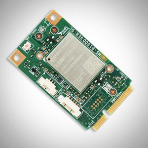
    Photo: Swift Navigation
    Photo: Swift Navigation

    Swift Navigation‘s new Precision GNSS Module (PGM) is now available. The PGM module is designed to offer fast evaluation and a quick path to production for those requiring a precise positioning solution.

    The PGM is available in a simple-to-use, industry-standard mPCIe (mini peripheral component interconnect express) format and is designed specifically for Swift’s Starling positioning engine running on a host application processor to deliver real-time precision navigation.

    The PGM utilizes STMicroelectronics’ TeseoV chipset in Quectel’s multi-constellation, dual-band LG69T-AP receiver to create an affordable, easy-to-use solution for customers building industrial, last-mile and internet of things (IoT) platforms, Swift Navigation said.

    The LG69T family of products, based on the ST TeseoV, is an designed for demanding precision applications that require centimeter accuracies. The LG69T-AP — supporting L1/L5 bands — has an integrated ST inertial measurement unit and processor to support dead reckoning for signal-compromised areas such as urban canyons, parking lots and underground structures.

    According to Swift Navigation, this proven solution is ready for fast and easy integration and deployment — using industry-standard protocols — to reduce customer engineering investment and enable quick time to market.

    This solution operates with the highest accuracy when used with Swift’s Skylark cloud-based, wide-area precise positioning service. Skylark delivers accuracy down to 10 cm. The solution supports standard RTCM OSR (Observation Space Representation) and SSR (State Space Representation) correction formats.

    Skylark is available for integration into wide-area, high-precision positioning applications across the continental United States and Europe and is available in Japan, South Korea and Australia, with plans underway to expand globally. Skylark is an ever-expanding service and is scalable to service millions of users.

    “We are excited to be offering the PGM utilizing the Quectel LG69T-AP receiver,” said Dave Huntingford, staff product manager at Swift Navigation. “The ability to provide a cost-effective, easily integrated solution, complete with corrections, opens up a host of opportunities for IoT, last-mile and industrial customers to benefit from precise positioning.”

    “Quectel is delighted to be working with Swift Navigation to provide the market with an easy-to-use precision GNSS solution,” said Mark Murray, vice president of sales for GNSS and automotive at Quectel Wireless Solutions. “The LG69T-AP, together with Swift’s Starling positioning engine and Skylark corrections, is perfect for supporting applications and markets where <10-cm accuracy is required.”

    This product is available today with full production by the first quarter of 2021;  an evaluation kit is available. Contact Swift Navigation or Quectel.