Blog

  • Directions 2021: Galileo expands and modernizes global PNT

    Directions 2021: Galileo expands and modernizes global PNT

    Authors Javier Benedicto (ESA), left, and Rodrigo da Costa (GSA). (Image: ESA)
    Authors Javier Benedicto (ESA), left, and Rodrigo da Costa (GSA). (Image: ESA)

    Throughout 2020, the Galileo Programme under the responsibility of the European Commission, the European GNSS Agency (GSA) and the European Space Agency (ESA), has been delivering continuous and reliable global PNT and Search and Rescue (SAR) services, developed improvements to Galileo First Generation ground and space system infrastructure for increased robustness and new service capabilities, and launched a full modernization program aiming in the future at Galileo Second Generation.

    The GNSS User Technology Report 2020 has just been released by GSA, providing a complete overview of the current status and trends of the GNSS worldwide market with focus on user technology and in particular European GNSS (Galileo and EGNOS) applications and services.

    In addition to providing a high quality open service based on innovative signals in the E1 and E5 bands, Galileo is also the first GNSS constellation to comprise a SAR capability, including the provision of a return link to users in distress. Galileo also features unique capabilities, such as the provision of Navigation Message Authentication (OS-NMA) and of an encrypted navigation signal on E6, the Commercial Authentication Service (CAS). These functions will offer the first protection against spoofing available to civilian GNSS users.

    Finally, Galileo will provide free access to a High Accuracy Service (HAS) through the use of an open data channel used to broadcast high-accuracy augmentation messages.

    Performance Meeting Expectations

    The Galileo constellation consists today of 22 operational spacecraft (24 satellites are available for the Search and Rescue service). Two additional satellites (GSAT0201/E18 and GSAT0202/E14) are currently under testing with regard to potential operational as auxiliary usage in the near future.

    The long-term evolution of performance parameters reveals that the Galileo system is continuously improving. In particular, an excellent quality of the navigation message in terms of ranging accuracy can be observed. Since the Initial Service declaration in 2016, ranging accuracy has steadily improved reaching a level of ~25 cm (95%) by mid of 2020, see Figure 1.
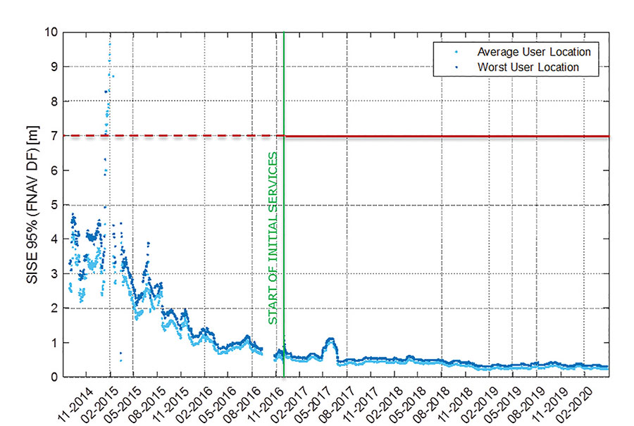
    FIGURE 1. F/NAV SISE as observed by user receivers (constellation average, 30 days moving average). (Image: ESA)
    FIGURE 1. F/NAV SISE as observed by user receivers (constellation average, 30 days moving average). (Image: ESA)

    The timing accuracy benefits from the larger number of satellites in service. Figures 2 and 3 present the evolution of the UTC dissemination accuracy and GGTO accuracy performance better than 2.5 nsec and 4.2 nsec (95%) respectively, which are largely within Galileo service commitments.
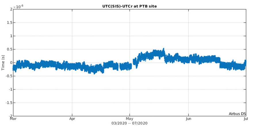
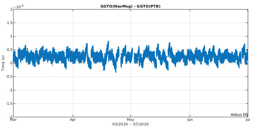
    Figure 2. UTC dissemination accuracy. (Image: ESA)
    Figure 2. UTC dissemination accuracy. (Image: ESA)
    Figure 3. GGTO accuracy. (Image: ESA)
    Figure 3. GGTO accuracy. (Image: ESA)

    Probably the most significant discriminator of Galileo versus other GNSS is its capability to broadcast multi-frequency (E1, E6, E5) signal components on all operational satellites. In the high-end and mid-range smartphone chipset market, dual frequency is becoming the norm. All large players have released dual-frequency chipsets, and the first dual-frequency chipsets targeting the budget device market are now becoming available. Dual-frequency receivers offer improved accuracy and robustness, and potential access to high-accuracy techniques. Multi-constellation is now standard for high-volume chipsets and Galileo with its multi-frequency capability is one of the largest GNSS contributors to this emerging dual-frequency PNT market.

    Expanding Galileo Services Portfolio

    Galileo offers the Galileo Open service (OS) for positioning and timing services, and Europe’s Search and Rescue (SAR) service contribution to COSPAS-SARSAT, equipped with its unique Return Link Message (RLM) declared operational in January 2020. Furthermore, the Galileo system is expanding its infrastructure capabilities such that, once fully operational, it will offer additional high-performance services worldwide.

    Public Regulated Service (PRS) is restricted to government-authorized users for sensitive applications that require a high level of service continuity.

    Open Service INAV message improvements on Galileo E1-B are under implementation, namely robust symbol level synchronization patterns, additional insertion of clock and ephemeris data with flexible outer encoding and frequent provision of shortened clock and ephemeris for improved robustness in terms of navigation data retrieval in challenging environments, in addition to facilitating a reduced time to first six (TTFF); these improvements ensure backwards compatibility with previously released OS SIS ICDs.

    Open Service Navigation Message Authentication (OS-NMA) providing the free authentication of the Galileo Open Service (OS) for geolocation information through the Navigation Message (I/NAV) broadcast on the E1-B signal component.

    Commercial Authentication Service (CAS), complementing the OS, providing a ranging authentication function implemented by encrypting the spreading code of the E6C (pilot) channel with a secret key. To ensure backward compatibility, CAS is based on the only civilian signal including cryptographic features (E6). When using both OS-NMA and CAS, users will benefit from data (navigation message) and range authentication, allowing PVT authentication worldwide.
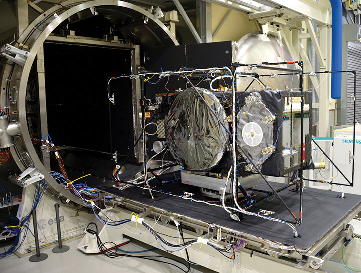
    Galileo Batch 3 satellite under test at ESA’s ESTEC facility in the Netherlands. (Photo: ESA)
    Galileo Batch 3 satellite under test at ESA’s ESTEC facility in the Netherlands. (Photo: ESA)

    High Accuracy Service (HAS) complementing the OS by delivering free access high accuracy data and providing better ranging accuracy, enabling users to achieve sub-meter level positioning accuracy.

    Support to Safety of Life (SoL) Services through Dual Frequency Multi-Constellation (DFMC) SBAS and supporting the provision of integrity through the concept of Horizontal Advanced Receiver Autonomous Integrity Monitoring (H-ARAIM). In this context, the Galileo Integrity Failure Mode and Effect Analysis (IFMEA) Process is implemented through measurements and review of the system design, including characterization of feared events.
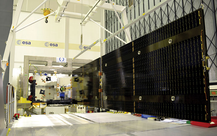
    Galileo Batch 3 satellite under test at ESA’s ESTEC facility in the Netherlands. (Photo: ESA)
    Galileo Batch 3 satellite under test at ESA’s ESTEC facility in the Netherlands. (Photo: ESA)

    Infrastructure Modernization

    The Galileo System infrastructure is being upgraded and modernized to support the full service portfolio, provide additional robustness and resilience, ensure security and improve operations.

    The Galileo Ground Segment is being upgraded implementing ground segment virtualization technologies. This modernized infrastructure will make it possible to easily accommodate technology refresh and will minimize impact to Galileo service operations, under the responsibility of Spaceopal GmbH, during future deployment activities.

    Current ground segment upgrades under production by prime contractor Thales Alenia Space in France (in charge of Ground Mission Segment and Security Monitoring) are addressing the deployment of improved robustness of the navigation and precise timing solutions, the full scope of PRS service capabilities, the expansion of the sensor station and up-link ground station networks, and additional security monitoring coverage to protect Galileo ground and space assets.

    Ground segment upgrades under production by prime contractor GMV in Spain are addressing the deployment of a new Ground Control Segment providing increased constellation monitoring and control capabilities up to 38 satellites, enhanced operability features, expansion of the TTC network and additional security protection capabilities.

    Upgrades of the Galileo Service Facilities are underway as well, notably the evolution of the GNSS Service Center toward the integration of the OS-NMA and HAS capabilities, and the extension of the reference measurement capabilities of the Galileo Reference Centre, by the prime contractor GMV in Spain. The robustness of the SAR service operations, under the prime contractor CNES in France, is also under improvement.

    The production of 12 additional Batch 3 Galileo first generation satellites is proceeding, aiming at readiness for launch from mid 2021 onward. Batch 3 satellites are comparable to the 22 FOC satellites launched previously and built by the same prime contractor OHB Systems in Germany. With Batch 3 satellites, Galileo will reach its full constellation capability, including a number of in-orbit spares.

    Galileo Batch 3 satellites will be progressively launched with the new Ariane 62 launcher vehicle, the two strap-on solid booster variant of Ariane 6, currently undergoing the final stages of development led by prime contractor ArianeGroup. Meanwhile, France’s space agency CNES is preparing the Ariane 6 launch facilities at Europe’s Spaceport in French Guiana. Ariane 6 is scheduled for its first launch in 2022.

    Europe’s new Ariane 6 launch vehicle. (Artist's concept: ESA)
    Europe’s new Ariane 6 launch vehicle. (Artist’s concept: ESA)

    Toward Galileo Second Generation

    The Galileo Programme is fully engaged in the process of developing Galileo 2nd Generation (G2G). Procurement activities for system, satellite and ground segment have been initiated in 2020 with the ambitious goal of starting deployment of the new infrastructure in 2024.

    The design of G2G is driven by overarching principles, including backward compatibility, providing an extended portfolio of services and the quality of services, but also the absolute need to meet user demands in a timely and effective manner. The European Commission, in close consultation with EU member states, has converged onto an ambitious set of long term PNT goals for the future European GNSS infrastructures.

    G2G Service Portfolio and High-Level Mission Objectives agreed with Programme Stakeholders Service include service evolutions in the areas of signals evolution for increased performance and reduced complexity and power consumption at the user receiver level, time to first-fix, accuracy, authentication and other service attributes, PRS evolutions, advanced timing services, enhanced integration with terrestrial systems (5G/6G), complementarity with external sensors (such as INS, barometer, lidar) and application environments (such as low power devices and internet of things), SAR service evolution, Emergency Warning services, Space Service Volume and Ionosphere Prediction Service.

    G2G will build on advanced navigation technology developed over the past 10 years under ESA’s European GNSS Evolution Programme (EGEP) and EU’s Horizon 2020 Programme. This technological leap will allow the early introduction of novel Galileo system features:

    • Open service capabilities (reduce power consumption and convergence time)
    • High-accuracy evolution (integrity, availability)
    • PRS robustness and transmit power
    • System and SIS in-orbit flexibility, reconfiguration and time-to-market
    • Inter-satellite links (ranging, mission dissemination, command and control)
    • SAR second-generation beacons
    • Reduce operations and maintenance cost
    • Accelerate time-to-market of new services
    • Ground technology virtualization and modernization

    Acknowledging the changing nature of user requirements, the Galileo second-generation is designed to evolve incrementally and with sufficient flexibility to provide new services or signal features, if and when required, by dynamic reconfiguration of space and ground infrastructure.
  • ION seeks abstracts for ION GNSS+ 2021

    ION seeks abstracts for ION GNSS+ 2021

    ION logoThe Institute of Navigation (ION) is seeking abstracts for ION GNSS+ 2021: GNSS + Other Sensors in Today’s Marketplace, which is slated to take place Sept. 20-24 in St. Louis. A virtual option for the show also will be available.

    The conference will feature two tracks: commercial and policy, and research. The commercial and policy tracks include high performance and safety critical applications; status and future trends in GNSS; and mass market and commercial applications. The research tracks include multi sensor and autonomous navigation; algorithms and methods; and advanced GNSS technologies.

    The conference will also feature a new competition, the High Precision GNSS Positioning on Smartphones Competition. According to ION, participants will use a pool of GNSS datasets collected from smartphones and accompanied with high accuracy ground truth to achieve the best accuracy with the datasets provided. The winner will be based on the accuracy of the results. Team winners will win a cash prize, the opportunity to present their results during ION GNSS+ 2021 and be recognized during the ION GNSS+ Awards Ceremony, ION added.

    Abstracts must be submitted by March 5. Find out how to submit abstracts here.

  • RedTail Lidar Systems demos mapping capability

    RedTail Lidar Systems partnered with an engineering firm to demonstrate the RTL-400 lidar system’s high-resolution, high-accuracy mapping capability.

    Cross-section of lidar point cloud (Image: RedTail Lidar Systems)
    Cross-section of lidar point cloud (Image: RedTail Lidar Systems)

    According to the company, its lidar imagery was used to generate as-built conditions of a steep ravine to aid in long-term monitoring of the slopes under which a natural gas pipeline was buried.

    A narrow road traversing the top of the ravine through which the pipeline was installed was of concern since the instability could be dangerous. Loss of vegetation along the buried pipeline’s path also makes the area especially susceptible to slides after heavy rainfall.

    Top view of lidar point cloud (Image: RedTail Lidar Systems)
    Top view of lidar point cloud (Image: RedTail Lidar Systems)

    The RTL-400’s high-resolution point cloud data of the 13-acre ravine area was captured in 10 minutes, RedTail Lidar Systems said. The as-built digital elevation model (DEM) created from the lidar point cloud can be compared to future DEMs to determine if any changes have occurred in the slope’s topology, which would serve to identify hazards and provide input for slip mitigation.

    RedTail Lidar Systems is a division of 4D Tech Solutions, a company focused on providing innovative technology-based solutions to address government and commercial customer needs.

  • SimActive integrates software in lidar solution for drones

    SimActive integrates software in lidar solution for drones

    Image: SimActive
    Image: SimActive

    SimActive Inc., a developer of photogrammetry software, has integrated its Correlator3D product into lidar systems for drones developed by Lidar USA.

    Possible configurations include two side-by-side cameras that allow matching the footprint of the lidar sensor, a particularly useful setup for corridor mapping.

    SimActive’s Correlator3D software is used for automatically registering the imagery with the lidar data. Once a perfect alignment has been achieved, the point clouds are colorized using the photos.

    “The ability to directly use lidar as control for adjusting image positions really is a unique feature,” said Jeff Fagerman, CEO at Lidar USA. “Correlator3D allows our clients to quickly combine lidar with data from multi-camera systems and produce high-quality outputs.”

    Correlator3D software is a patented end-to-end photogrammetry solution for the generation of high-quality geospatial data from satellite and aerial imagery, including drones. Correlator3D performs aerial triangulation and produces dense digital surface models, digital terrain models, point clouds, orthomosaics, 3D models and vectorized 3D features.

    Powered by GPU technology and multi-core CPUs, Correlator3D’s processing speed supports rapid production of large datasets.

    Lidar USA, also known as Fagerman Technologies, is a family owned business just outside of Huntsville, Alabama. Lidar USA specializes in laser scanning, photogrammetry, instrumentation and all things geomatics.

  • Septentrio opens R&D center in Espoo, Finland

    Septentrio opens R&D center in Espoo, Finland

    Aerial shot of Espoo, Finland, from a drone. (Photo: izhairguns/iStock/Getty Images Plus/Getty Images)
    Aerial shot of Espoo, Finland, from a drone. (Photo: izhairguns/iStock/Getty Images Plus/Getty Images)

    Expansion enables company to further accelerate cutting-edge GNSS/INS solutions for professional and industrial applications

    Septentrio has opened a new Research & Development center in Espoo, Finland, to support the strong growth and ambitious expansion plans for its GNSS/INS solutions for professional and industrial applications.

    The new office is strategically located in Espoo, well known as a high-tech hub with a long history of state-of-the-art GNSS and INS development, housing many leading technology companies as well as Aalto University.

    “This new R&D center will support our strong growth and further accelerate our strategic agenda of becoming the leading independent GNSS/INS supplier for demanding applications in industrial, scientific and infrastructural domains,” said Antoon De Proft, CEO at Septentrio. “We also welcome Stefan Söderholm, who brings a wealth of experience to our team and will lead the new R&D center in Finland.”

    “I am really excited to join Septentrio,” added Söderholm. “I have always been impressed by its technology and I look forward to be part of this great team that develops unique positioning solutions for the industry.”

    Septentrio will be expanding its R&D team in the coming months with enthusiastic and highly qualified GNSS and INS engineers as well as software engineers. Stefan Söderholm will spearhead the establishment of the new R&D center and the recruitment efforts.

  • GPS military code receives operational acceptance for early use

    GPS military code receives operational acceptance for early use

    The Space and Missile Systems Center’s Production Corps achieved a major GPS milestone on Nov. 18 with the approval for Operational Acceptance of GPS Military-Code (M-Code) Early Use (MCEU). MCEU serves as a gap filler for M-code operations before the entire GPS constellation’s operational transition to the Next Generation Operational Control System Block 1.

    The encrypted M-code signal enhances anti-jamming and anti-spoofing capabilities for the warfighter. M-code signals are available on all 23 GPS Block IIR-M, IIF and III space vehicles currently on orbit. The successful testing events were completed at the Master Control Station at Schriever Air Force Base, Colorado and Alternate Master Control Stations at Vandenberg Air Force Base, California.

    Operational Acceptance followed successful integrated developmental and operational testing of the GPS Operational Control Segment (OCS) upgrade. Operating in a trial period since June 2020, the MCEU upgrade allows the OCS Architecture Evolution Plan to task, upload and monitor M-code within the GPS constellation, as well as support testing and fielding of modernized user equipment. With M-code now declared operational, upcoming Military GPS User Equipment (MGUE) will be able to request early use of the M-code signal-in-space to provide more secure position, navigation and timing (PNT) to warfighters.

    “MCEU ushers in a new era of GPS support that will provide operators across the warfighting domain with assured PNT access while further preventing unauthorized use by our adversaries. This is a critical step in remaining the gold standard of PNT systems and promoting a peaceful, secure, stable, and accessible space domain,” said Lt. Jordan Malara, 2nd Space Operations Squadron GPS Warfighter Collaboration Cell assistant flight commander.

    M-code designed for security

    Military code (M-Code) is a more-secure, harder-to-jam and spoof GPS signal specifically for military forces. Awarded in September 2017, M-Code Early Use (MCEU) is a software upgrade to the OCS AEP, which allows the current ground control system to task, upload and monitor M-Code within the GPS constellation. It will also help Accelerating M-Code’s deployment supports testing and fielding of modernized user equipment in support of the warfighter.

    MCEU includes a new software-defined receiver installed globally at all six Space Force Monitoring Sites. The M-code Monitor Station Technology Improvement and Capability (M-MSTIC) uses commercial, off-the-shelf hardware to cost effectively receive and process M-code signals, enabling OCS operators to successfully monitor the M-code signals.

    “M-code’s more-secure, harder-to-jam and spoof signals are critical to helping our warfighters complete their missions, especially in contested environments,” said Maria Demaree, vice president and general manager for Lockheed Martin’s Mission Solutions line of business. “This upgrade to the current GPS ground control system, and the launch of more modernized GPS III satellites, is making M-code’s full-fielding a reality.”

    With the Dec. 1 Operational Acceptance of GPS III Space Vehicle 04 (GPS III SV04), 23 GPS IIR-M, GPS IIF and GPS III satellites broadcast M-code in the current GPS Constellation.

    Ground Control Timeline — OCS AEP

    Lockheed Martin has sustained the Space Force’s current GPS ground control system since 2013. The system is known as the GPS Operational Control Segment (OCS) Architecture Evolution Plan (AEP) or “OCS AEP.”

    In February 2016, the Air Force contracted Lockheed Martin to develop the GPS III Contingency Operations (COps) software upgrade to the OCS AEP. COps was delivered in May 2019, successfully connected with on-orbit GPS III SV01 in October 2019, and was Operationally Accepted in February 2020. COps enabled the Air Force’s ground control system to command and control both the legacy satellites, as well the more powerful GPS III satellites beginning to launch.

    In November 2018, the company completed the AEP 7.5 upgrade — the largest architectural change in the systems history — replacing significant code, hardware and software to improve the system’s cybersecurity capabilities and positioning the Air Force to better operate in contested, degraded and operationally limited environments.

    In December 2018, the Air Force awarded Lockheed Martin the GPS Control Segment Sustainment II (GCS II) contract to continue to further modernize and sustain the OCS AEP through 2025.

    In the fourth quarter of 2019, Lockheed Martin delivered the Red Dragon Cybersecurity Suite (RDCSS) Phase III upgrade to the OCS AEP, dramatically improving Defensive Cyber Operations (DCO) visibility into GPS network traffic. Other add-ons include user behavior analytics to analyze patterns of traffic and network taps to improve data collections.

    Earlier this year — and key to enabling M-Code — Lockheed Martin installed new software-defined M-Code Monitor Station Technology Capability (M-MSTIC) receivers at six Space Force monitoring sites around the world. In Dec. 2019, SMC granted security approval for M-MSTIC.

    From his side window, a crew chief relays vital position information back to the CH-47 Chinook pilot as paratroopers hook their pallet of equipment to the underside of the helicopter during sling load and air operations training. (Photo: U.S. Army/Maj. Robert Fellingham)
    From his side window, a crew chief relays vital position information back to the CH-47 Chinook pilot as paratroopers hook their pallet of equipment to the underside of the helicopter during sling load and air operations training. (Photo: U.S. Army/Maj. Robert Fellingham)
  • Reps. Thompson, Peterson and Comer push leadership to delay Ligado application

    Reps. Thompson, Peterson and Comer push leadership to delay Ligado application

    Image: A-Digit/DigitalVision Vectors/Getty Images
    Image: A-Digit/DigitalVision Vectors/Getty Images

    Ligado application will bring harmful interference to critical technologies

    U.S. Representatives Glenn “GT” Thompson (R-PA), Collin Peterson (D-MN) and James Comer (R-KY) sent a letter Nov. 24 to House Leadership and the Appropriations Committee requesting language delaying implementation of the April 2020 Federal Communications Commission (FCC) order granting Ligado’s application to deploy a terrestrial nationwide network to provide 5G services.

    In July, the Congressmen expressed serious concerns surrounding the FCC’s decision, questioning the reliability of GPS for millions of Americans, especially the farmers and ranchers who rely on this technology each and every day for precision agriculture.

    “Investments in 5G and GPS are critically important to the American economy, especially the agriculture industry,” said Rep. Thompson. “However, the Ligado decision will have negative impacts on GPS and satellite communications, hindering reliability and slowing progress on current and future innovation of this technology. I urge my colleagues in leadership and on the Appropriations Committee to delay this harmful implementation.”

    “There is no room for error when discussing safety and reliability of service for GPS signals. Aviation, agriculture, and other vital industries rely on consistent signal quality,” said Rep. Peterson. “Safety and national security issues remain unresolved under the current order, which is why it is vital that we delay Ligado’s 5G deployment.”

    “Our farmers are vitally important to providing the food supply for America and the world, and a reliable GPS network is critical to precision agriculture,” said Rep. Comer. “I understand the importance of improving telecommunications operations, especially for advancing rural economies. But critical tools like GPS technology must not be disrupted, as our farmers are essential workers who must have the tools they need to do their jobs. It is our responsibility as policymakers to fight to ensure that federal agency decisions do not negatively impact Americans’ livelihoods. It is my hope that this language to delay implementation of the Ligado order will be addressed in a year-end appropriations package.”

    “The FCC’s ill-advised decision on the Ligado matter risks serious negative impacts to the communication of real-time environmental data from satellites that are a primary tool by the American Weather Enterprise in the creation and timely dissemination of accurate weather forecasts and severe weather warnings,” said Jonathan Porter, vice president and general manager, AccuWeather. “Any degradation in these communications will endanger critical economic and societal benefits for weather-sensitive businesses from family farms to large corporations and reduce the ability for people to stay safe during severe weather.”

    “GPS is critical to precision agriculture applications that deliver centimeter level accuracy that enables farmers to maximize crop yields while lowering costs and environmental impact,” said Dale Leibach, spokesperson for the Keep GPS Working Coalition. “The FCC’s decision represents a sweeping governmental and regulatory assault on farmers who are already facing unprecedented challenges including severe weather, low commodity prices, and supply chain vulnerability as a result of COVID-19. The order must be stopped, and Congressman Thompson and Chairman Peterson have been relentless champions for farmers in the effort to reverse the FCC’s decision.”

    “GPS technology is a key component to precision agriculture, a sustainable practice that benefits both farmers and the environment,” said Dennis Slater, president of the Association of Equipment Manufacturers. “The recent Ligado decision will hinder these hard-working Americans from being able to properly utilize the tractors, combines, harvesters, and other modernized equipment we manufacture. We urge House leadership to include language to delay Ligado implementation. Farmers are already struggling due to the pandemic, natural disasters, and other factors. Let’s not add to their economic pain.”

    “Protecting the public interest and our economic security requires defending and protecting critical GPS, satellite communications services, aviation navigation equipment and essential weather apparatus. But Ligado’s reckless venture puts that at risk,” said Jordan Hassin, director, Corporate Communications, Public Relations, and Industry Affairs for Iridium Communications. “As more users of services in the L-band discover the threat Ligado presents to their livelihoods, more of our policymakers are recognizing that they need to demand this threat be addressed either in the NDAA or in an end of year spending package. This is not just a defense issue. We are grateful to the leaders of the Agriculture Committee for adding their voices to the call for a change to the FCC’s misguided and destructive decision.”


    Feature image: A-Digit/DigitalVision Vectors/Getty Images

  • U-blox signs deal with UK start-up for cutting-edge GNSS technology

    U-blox signs deal with UK start-up for cutting-edge GNSS technology

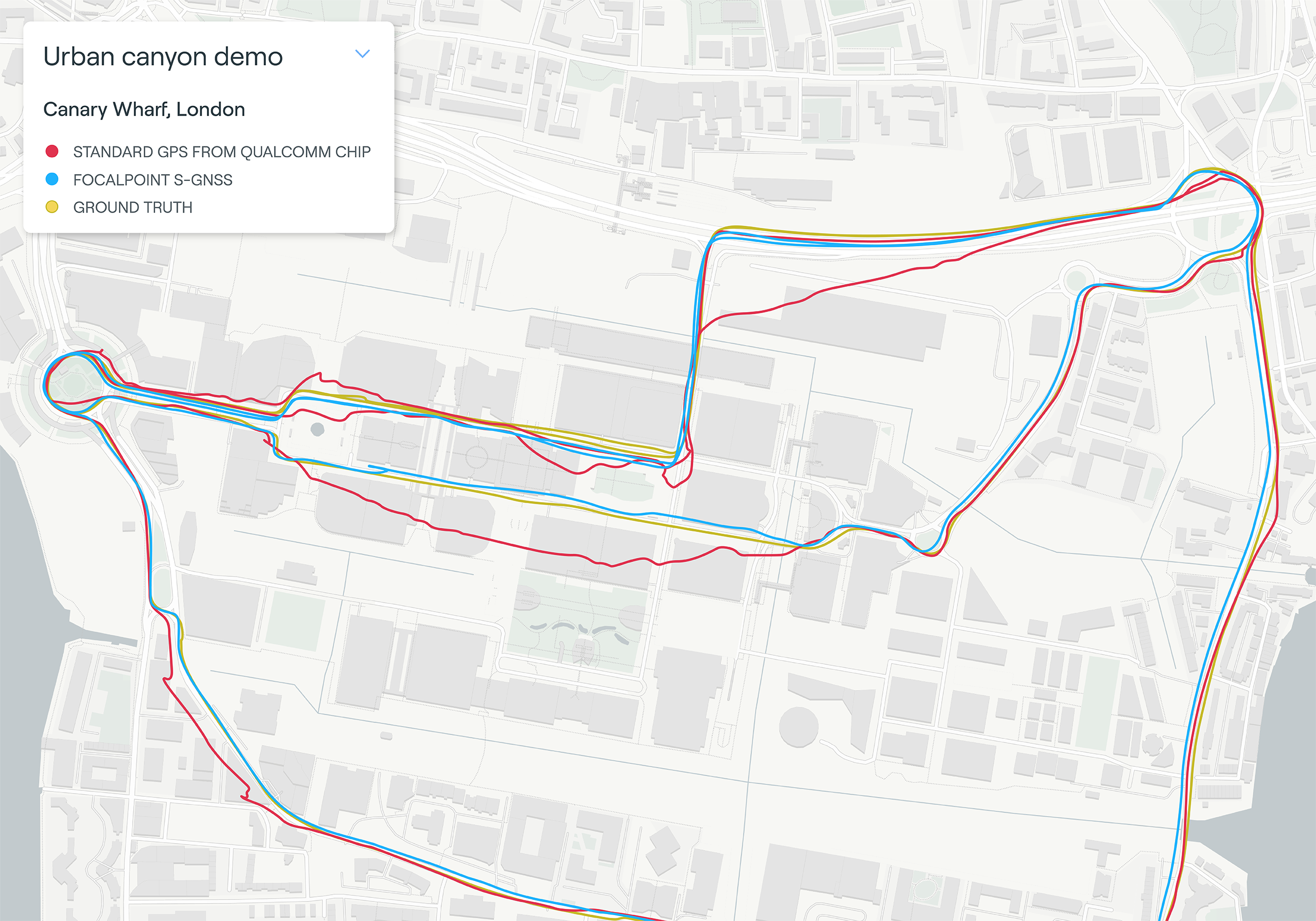
    Map plot from live tests in London show the route of a vehicle driven through Canary Wharf. It shows the difference between the position provided by a standard smartphone GNSS chip (red line) and the same data run through Focal Point Positioning's Supercorrelation software (blue line). (image: u-blox)
    Map plot from live tests in London show the route of a vehicle driven through Canary Wharf. It shows the difference between the position provided by a standard smartphone GNSS chip (red line) and the same data run through Focal Point Positioning’s Supercorrelation software (blue line). (Image: u-blox)

    U-blox has signed a deal with the award-winning U.K.-based technology company Focal Point Positioning to integrate technology that will improve the accuracy and reliability of GNSS devices. Focal Point’s Supercorrelation technology enhances positioning performance and security for applications such as smart cities, location-secure internet of things (IoT) and health and fitness wearables.

    The patented Supercorrelation technology solves a critical weakness in GNSS caused by multipath interference. Multipath interference occurs when satellite signals bounce off buildings and landmarks, causing GNSS receivers to provide degraded positioning outputs.

    The result for users is that the blue dot on their phone or device may be in the wrong place, moving in the wrong direction, or may have a large error ellipse. For autonomous vehicles it could lead to positioning errors that place the vehicle in the wrong lane or worse.

    FocalPoint’s Supercorrelation technology uses software to detect and reject reflected signals, resulting in an improvement in the performance of GNSS devices without the need for additional hardware or applications. Supercorrelation also helps with the detection and rejection of GNSS spoofing signals — an increasing concern for autonomous vehicles, ships, and aviation.

    “We are tremendously excited to be working alongside a market leader such as u-blox, our mission is to improve every positioning system on the planet and we have taken a giant step forward in that vision with this deal,” said Focal Point Positioning CEO Ramsey Faragher. “Positioning systems are so critical to our world, and we look forward to seeing the next generation of products and services that will be enabled by this higher level of accuracy, reliability and security.”

    u-blox CEO Thomas Seiler commented, “The addition of Supercorrelation technology into our latest GNSS platforms is part of our continuing focus on low power consumption, higher accuracy and security for automotive, industrial, and wearable GNSS applications.”

  • Coalition supports NDAA provisions to protect GPS against Ligado

    Coalition supports NDAA provisions to protect GPS against Ligado

    Photo: Andrea Izzotti/Shutterstock.com
    Photo: Andrea Izzotti/Shutterstock.com

    The Keep GPS Working Coalition issued the following statement in support of the inclusion of provisions related to GPS in the William M. “Mac” Thornberry National Defense Authorization Act (NDAA) for Fiscal Year 2021. Provisions included are intended to protect GPS signals against interference, specifically against any caused by Ligado Networks.

    The coalition was formed in response to a Federal Communications Commission (FCC) order allowing Ligado Networks to operate a terrestrial wireless network that the coalition says will threaten the reception of millions of GPS devices.

    The coalition stated,

    “The Keep GPS Working Coalition applauds this year’s NDAA, which includes important provisions addressing the potential for interference to GPS caused by the use of the L-band spectrum owned by Ligado Networks. The inclusion of these provisions signals a clear understanding by Congress that preventing GPS interference is a matter of safeguarding our national security. First and foremost, the legislation provides for a thorough, independent review of the Federal Communications Commission decision allowing Ligado to operate its planned terrestrial wireless network.

    “The FCC’s Ligado order, which relies heavily on inaccurate and incomplete technical submissions by Ligado, was issued despite national and economic security concerns raised by the Department of Defense, along with the Departments of Commerce, Interior, Justice, Homeland Security, Energy and Transportation, as well as NASA, the National Science Foundation, the Coast Guard and the Federal Aviation Administration. Independent review is an important first step in ensuring that Ligado’s operations will not damage the nation’s critical GPS based infrastructure or the hundreds of millions of GPS devices used in critical activities. This review and the other NDAA provisions included will also help ensure that appropriate safeguards are in place to hold Ligado accountable for all costs to U.S. taxpayers, businesses and consumers that will result from these operations.

    “We are particularly grateful to Senators Inhofe and Reed and Representatives Smith, Thornberry, Turner and Cooper for their leadership on this critical issue.”

    More than 50 organizations signed a Nov. 20 letter urging the chairmen and ranking members of the House and Senate Armed Services Committees to continue their support for provisions aimed at protecting GPS from harmful interference from Ligado Networks’ planned network.

    According to the Senate Armed Services Committee, “The bill protects both critical military applications and numerous civilian uses of the Global Positioning System (GPS) from potentially harmful interference, and outlines a path forward following the Federal Communications Commission’s (FCC) decision to approve Ligado Networks’ request for bandwidth for a terrestrial-based cellular network that put critical GPS signals at risk. The bill prohibits the use of DOD funds to comply with the FCC Order on Ligado until the Secretary of Defense submits an estimate of the costs associated with the resulting GPS interference, and directs the Secretary of Defense to contract with the National Academies of Science and Engineering for an independent technical review of the order to provide additional technical evaluation to review Ligado’s and DOD’s approaches to testing. The bill also prohibits the Secretary of Defense from entering into or continuing a contract with any entity engaged in commercial terrestrial operations within the frequency bands specified in the Ligado FCC order.”

  • Open PNT Industry Alliance launched to strengthen national resilience

    Open PNT Industry Alliance launched to strengthen national resilience

    Coalition gives voice to PNT companies seeking open-market approach to backing up GPS/GNSS for critical infrastructure

    Open PNT logoSeveral GNSS and positioning, navigation and timing (PNT) companies have joined forces to create a new lobbying group, the Open PNT Industry Alliance. Founding companies include InfiniDome, Iridium Communications, Jackson Labs Technologies, NAVSYS Corporation, NextNav, OPNT, Orolia, Qulsar, Satelles and Seven Solutions.

    In the United States, the coalition believes the Executive Order on “Strengthening National Resilience Through Responsible Use of Positioning, Navigation, and Timing Services,” issued in February 2020 begins the process for a national alternative PNT policy.

    The Open PNT Industry Alliance also agrees with the U.S. Department of Homeland Security’s findings and recommendations in its “Report on Positioning, Navigation, and Timing (PNT) Backup and Complementary Capabilities to the Global Positioning System (GPS)” submitted to the U.S. Congress in April.

    The report was criticized by some lawmakers for inaccuracies and lack of depth, but several companies whose solutions were referenced in the report defended it, and have now joined in creating this new alliance.

    The alliance expects to support similar initiatives in other countries.

    The coalition is designed to fortify economic and national security by supporting government efforts to accelerate the implementation of backup PNT capabilities for critical infrastructure. Other companies sharing these views are invited to join the alliance.


    The Open PNT Industry Alliance will be introduced in an Orolia PNT Coffee Talk webinar on Thursday, Dec. 17, at 10 a.m. EST.


    A serious problem facing nations around the world is that GPS and other GNSS are susceptible to inadvertent disruptions and deliberate attacks. Such incidents have the potential to impair or incapacitate communications networks, transportation systems, energy production and distribution platforms, financial services operations and other types of critical infrastructure.

    With the scope, complexity and severity of disruptions and attacks evolving continuously, the combination of wide-ranging PNT solutions and emerging technologies offers superior protection to current threats by providing a backup to GPS/GNSS and improving national resilience.

    “Multiple forms of alternative PNT deliver the broadest possible range of operational and performance characteristics to meet the diverse needs of applications across all industry sectors, plus they can better adapt to future threats than a single technology with its inherent vulnerabilities,” said Michael O’Connor, CEO of Satelles. “The mission of the Open PNT Industry Alliance is to promote open-market concepts that preserve industry’s long-term ability to harness its inventive talent to protect GPS/GNSS with multiple solutions that are technologically advanced, commercially viable, and based on a sustainable long-term funding framework.”

    logosThe Open PNT Industry Alliance will share its expertise with governments to aid their efforts to set policies, define regulations, and enact laws that achieve their national resilience objectives while preserving competition in the open market. A principal purpose of the coalition is to stimulate and capitalize on the collective intellect of industry in a collaboration between the public sector and private sector.

    “The ingenuity of the private sector is spurred by competition and public and private investment, and this will drive the emergence of multiple GPS/GNSS alternatives that are cost-effective and evolve according to threat profiles, technological innovations, and market dynamics,” said Jean-Yves Courtois, CEO of Orolia. “Similarly, unbridled innovation will address new and still evolving use cases not supported by GPS/GNSS.”

    The coalition will work closely with governments as they consider plans for regulation of critical infrastructure sectors and funding for alternative PNT. Legislators and policymakers can best pursue national interest through a multi-technology approach to PNT resilience, the coalition stated in a press release. The coalition will advocate for the establishment of a robust and self-sustaining funding framework that allows for the development and adoption of multiple sources of PNT that meet the needs of various sectors and industries.

    “We believe a multi-technology approach to PNT resilience not only meets a more diverse set of critical infrastructure needs but also ensures a more robust approach to security by providing multi-layer resilience,” said Ganesh Pattabiraman, CEO of NextNav. “Delivering alternative PNT capabilities on an equal footing with GPS will require government policies and funding that ensure these solutions are cost-effective for critical infrastructure providers and sustainable over the long term.”

    The Open PNT Industry Alliance website has background on members and policy views, as well as information on how companies can join.

  • FLIR Systems acquires Altavian for defense sUAS

    FLIR Systems acquires Altavian for defense sUAS

    Photo: FLIR Systems
    Photo: FLIR Systems

    FLIR Systems Inc. has acquired Altavian Inc., a privately held manufacturer of small unmanned aerial systems (sUAS) for defense and public-safety customers.

    Altavian’s airframes integrate multiple sensors, including FLIR thermal technology, to provide users with decision support and intelligence, surveillance and reconnaissance (ISR) capability.

    Based in Gainesville, Florida and founded in 2011, Altavian designs and manufacturers Group 1 UAS solutions for long or short range operations. With both quadcopter and fixed-wing UAS designs, Altavian’s expertise includes aeronautics, avionics, and software, and its solutions are engineered around an open system architecture aligned to the needs of government and defense customers.

    Altavian is one of five drone manufacturers approved by the U.S. Department of Defense under the Blue sUAS program to sell to the U.S. military and federal agencies.

    “Altavian’s proven engineering expertise and assets will allow us to offer customers the most comprehensive solution portfolio of any American sUAS provider,” said Roger Wells, general manager of the Unmanned Systems and Integrated Solutions business of FLIR Systems’ Defense Technologies Segment, under which Altavian will be integrated. “With the addition of both a low-cost, rapidly deployable quadcopter and a longer range fixed-wing UAS, FLIR is strengthening its already impressive drone lineup, including our Black Hornet and SkyRaider platforms used extensively by militaries around the globe. We’re excited about the multiple new franchise opportunities FLIR will be able to pursue for defense, public safety, and industrial markets worldwide.”

    For more information about FLIR Systems’ existing sUAS solutions, visit flir.com/defense-uas.

  • Trimble RTX corrections now transmitted through Sirius XM

    Trimble RTX corrections now transmitted through Sirius XM

    Photo: Photo: Blue Planet Studio/iStock/Getty Images Plus/Getty Images
    Photo: Blue Planet Studio/iStock/Getty Images Plus/Getty Images

    Trimble RTX GNSS corrections are now being transmitted through the SiriusXM satellite radio network, specifically through Sirius XM Connected Vehicles Services.

    As a result, new cars sold in the contiguous U.S. and Canada equipped with SiriusXM’s Gen8 satellite chipset will be able to receive RTX GNSS corrections, enabling high-accuracy positioning — a key component of autonomous on-road applications.

    With the addition of the Trimble RTX Auto software library, any new vehicle that receives SiriusXM broadcasts with a Gen8 satellite chipset can leverage a positioning solution ideal for advanced driving assistance systems (ADAS), autonomous driving (AD) and vehicle-to-everything (V2X) applications.

    Because the SiriusXM hardware is already installed in most new vehicles, automotive OEMs can avoid the cost of additional hardware to receive GNSS positioning corrections.

    “We are excited to add Trimble RTX Corrections to our suite of Connected Vehicle services,” said John Jasper, senior vice president for SiriusXM Connected Vehicle Services. “By delivering this service over our satellite broadcast network, automakers can access relevant location correction data throughout the contiguous U.S. and portions of Canada to facilitate ADAS, AD and V2X applications without the need to access a cellular network.”

    Trimble RTX is a trusted precise-positioning technology of choice for car manufacturers and their suppliers, and was the first solution adopted for production use in passenger vehicles. RTX technology is a critical component of General Motors’ Super Cruise™ system—the first hands-free driving assistance system for the highway. To date, Super Cruise and Trimble RTX have enabled over 5 million miles of hands-free driving on America’s roadways.

    Designed for automotive applications, the RTX Auto software library is Automotive Safety Integrity Level B (ASIL-B) certified and developed using the Automotive SPICE process maturity framework (Software Process Improvement and Capability Determination – ISO 15504). The RTX network operation is certified according to ISO 20000 standards, providing further peace of mind for any industry deploying safety-critical applications. No other precise positioning solution offers the same level of performance, reliability, versatility and coverage worldwide.

    Trimble RTX technology provides real-time, multi-constellation correction of GNSS observations to provide significantly more precise position estimates. Standard GPS signals can drift up to 25 feet, which could cause incorrect lane identification. When used in conjunction with high-definition maps, cameras, radar and inertial sensors, Trimble RTX provides lane-level positioning performance for semi-autonomous and autonomous vehicles.

    “The alliance with SiriusXM provides an expansive distribution pipeline for Trimble RTX into new passenger vehicles,” said Patricia Boothe, senior vice president of Trimble’s Autonomy Sector. “OEMs now have an easy, cost-efficient alternative to bring high-precision GNSS into their vehicles. Together, Trimble and SiriusXM are helping to accelerate the adoption of real-time positioning in connected vehicles, ultimately supporting safety-critical V2X applications.”