How is the completion of Galileo and BeiDou affecting the development of autonomous vehicles?
Ismael Colomina, chief scientist, Geonumerics
“GNSS has had a limited impact on the development of AVs because their developers regard it as insufficiently accurate, reliable, and ubiquitous. Only a minority of them are aware of the benefits that the new/modernized constellations bring. More and improved signals and new services— both commercial and public—such as Galileo’s HAS, NMA and CAS will enable and complement visual, lidar and radar sensors for SAE levels of automation 2 and higher and for ASIL D safety levels.” Ismael Colomina GeoNumerics
Ellen Hall, Spirent Federal System
“Safety is critical to the implementation of AVs and this safety relies upon PNT accuracy, availability and robustness. These three requirements all benefit from constellation diversification in terms of multiple signals, frequencies, satellites, and constellation providers. In addition to the four civilian signals available on three frequencies from the GPS constellation, signals from Galileo and BeiDou provide suitably equipped receivers with extra satellites, signals and ground segment diversity.” Ellen Hall Spirent Federal Systems
Brad Parkinson
“The economic potential of self-driving vehicles is the major driver for their development. Can they be made affordable, safe, dependable, and useful? More operational GNSS constellations may help resolve these issues favorably, but GNSS progress should not significantly influence the large number of developers. My favorite such application is long-haul trucking, which may have some very favorable profit and safety benefits.” Bradford W. Parkinson Stanford Center for Position, Navigation and Time
Image: metamorworks/iStock/Getty Images Plus/Getty ImagesChris Hogstrom, Spirent Federal Systems
Inertial navigation systems (INS), like most navigation systems, have evolved through countless iterations and improvements over many years. An INS, unlike other navigation technologies, does not rely on any external signals or inputs to aid navigation. It is, therefore, extremely difficult to spoof, jam or disrupt the system, and solar flares, ground/sky visibility and climate do not affect its ability to aid in navigation — unlike GNSS.
An INS knows where it is going because it knows where it has been. Modern INS use a minimum of three orthogonal accelerometers to measure accelerations in the x, y, z planes and a minimum of three orthogonal gyroscopes to measure the angular accelerations about the x, y, z planes. When the INS is initializing, its current location is fed into the system. After initialization, the INS utilizes the sensor outputs to determine its position relative to its starting point.
The INS made its debut during World War II, where it was used to guide German V2 missiles. At the time, the INS was still rather primitive, using two two-degrees-of-freedom gyroscopes and one integrating accelerometer. It wasn’t until the war’s end that Wernher von Braun and his team developed a stable platform with three single-degree-of-freedom gyroscopes and an integrating accelerometer.
World War II Innovation
Once the war was over, the United States Army acquired many of the lead scientists from the German V2 project and furthered research into INS. The Air Force also had an interest in INS and contracted Northrop Aircraft (now Northrop Grumman) to develop the guidance system aboard the SNARK cruise missile. However, the work under Charles Draper at MIT’s Instrumentation Laboratory spearheaded INS for use in aircraft. Draper was an amateur pilot and quickly saw the benefits that a self-contained system provided over the navigation systems of the day. The developments made by the Instrumentation Laboratory led to the success of the inertial-guided transcontinental flight in 1953.
By the late 1960s, military bombers and aircraft used INS, and by the early 1970s, it was commonplace in commercial aircraft, too. Today, INS technology can be found in aircraft, spacecraft, ships and submarines, as well as smartphones, watches and other wearable tech. It has quickly become an essential enabling technology for autonomous vehicles, and future applications are being studied.
The biggest weakness of INS is that they drift over time. This means that the longer an INS functions, the less accurate it becomes. For this reason, many INS are part of a sensor-fusion system. Incorporating data from many different sensors — such as GPS, a barometer, a compass and INS — a sensor-fusion system combines data through a Kalman filter to determine a more reliable and accurate positioning and navigation solution.
Best of Both Worlds
By combining INS with GPS, you get the benefit of both systems while minimizing their weaknesses. GPS and other GNSS have quickly become the gold standard for accurate positioning, as well as being the only global source of absolute position. Receivers tracking four or more satellites can provide their precise location anywhere on Earth.
However, GPS has significant and well-documented weaknesses. These stem, primarily, from the fact that GPS signals are extremely weak by the time they reach terrestrial users. This means that GPS signals, intentionally or otherwise, are easy to jam, and the broadcast nature of the signals means they are open to a variety of spoofing attacks. Fusion systems using an INS and GPS receiver can rely on GPS when the GPS signal is unobstructed, and switch to the INS solution when GPS is unreliable.
In a world where aircraft are now able to fly themselves and cars are quickly achieving autonomy, our dependence on these sensors is ever-increasing. Autonomous solutions with a navigation sensor suite of multiple sensor types are becoming common. Sensor suites can include other vehicle sensors that aid absolute positioning by sensing parameters such as steering angles, wheel rotations, etc. They are also beginning to incorporate non-GNSS-based RF signals to aid in navigation. Multiple sensors offer increased redundancy, helping achieve the required safety levels and the desired performance boundaries.
High-Mileage Testing
Testing and optimizing these sensor-fusion systems presents a serious challenge, especially in the transportation sector. Testing on a live platform can be hugely expensive and lacks any chance of repeatability. For these reasons, simulation is critical. In addition, representative models must take into account the impact of the environment and the dynamics of the vehicle frame (where sensors are installed) to achieve the requisite realism.
My company, Spirent Federal, has spent the past 20 years building sophisticated and robust test solutions so that sensor-fusion systems can be fully tested and characterized. Thorough testing increases performance and reliability in safety- and mission-critical applications.
Specifically, our GSS7000 and GSS9000 GNSS simulators deliver the precision and fidelity needed for high-performance applications, while our inertial emulation platforms incorporate the key industry models of both inertial measurement units (IMUs) and embedded GPS/inertial (EGIs) for dynamic integrated testing in the lab.
We work closely with major defense contractors, such as Northrop Grumman and Honeywell, to provide robust test solutions as well as alternative RF PNT simulation capabilities.
In addition, hardware-in-the-loop incorporation with ultra-low latency, modeling signal propagation in a 3D environment — and the ability to “shift left” with software-only testing — are what helps to make Spirent Federal the trusted partner in sensor fusion development.
Chris Hogstrom is an engineer with Spirent Federal Systems.
The Empire State Building sits atop a massive and solid foundation that hardly anyone ever sees. Above ground it has 2.8 million square feet of offices and hundreds of businesses. It houses 15,000 workers. Yet it would all come crashing down if the underlying and unseen foundation weren’t incredibly strong and dependable.
Timing is the unseen foundation of every networked technology, digital broadcast, financial transaction, electrical grid management and of most navigation systems, just to name a few applications. Yet, as GPS World readers know, signals from our dominant source of timing — GPS — are very faint and easily disrupted.
Short term, localized disruptions happen all the time, and many systems have adapted. A delivery driver using a jammer to hide from his boss is unlikely to disrupt a cell base station as he passes by, for example.
Photo: Georgijevic/E+/Getty Images
But more serious threats are out there. More and more hobbyists are finding ways to spoof receivers. Every few decades the sun flares strongly enough to fry satellites or charge the ionosphere. And because there are so few alternatives, GPS and other GNSS have become huge, tempting targets for adversary nations, terrorists, and sophisticated hackers.
Instead of Manhattan bedrock, our timing foundation is sometimes more like shifting sands.
Systems engineering tells us that, if something is essential, there ought to be two, three or more independent ways of receiving it. Most aircraft, for example, have two or three systems powering the flight controls — because controlled flight is important!
The white paper “A Resilient National Timing Architecture” outlines how the United States can leverage existing infrastructure and provide all citizens two, and many of them three, independent paths to coordinated universal time (UTC).
It proposes a national timing back- bone of mature technologies with very different failure modes — GNSS, eLoran and fiber. This combination will provide rock-solid timing at the 500 ns or better level of accuracy relative to UTC everywhere across the nation, and at 100 ns or better in major metro areas. Users accessing two or more systems would be nearly bulletproof to timing service disruptions.
The National Timing Resilience and Security Act of 2018 mandated a terrestrial system to back up GPS timing. Our white paper provides a path forward.
Complying with the law while benefiting current and future technologies should be sufficient motivation. If it isn’t, we must also realize that not acting on this will continue to place us behind other nations such as the United Kingdom, South Korea, Russia and China — all of whom are actively reinforcing their national timing systems.
The task will not be a simple one. Yet America was able to overcome the expense and difficulties of building GPS, at the time the world’s most refined and complex technology, and put it in space. By comparison, establishing a resilient national timing architecture using existing technology in our homeland would be child’s play.
Timing is essential. It is infrastructure for our infrastructure. If our national timing is weak, so is everything that is built upon it.
We will profit from ensuring our timing is as strong, resilient, and easily accessed as possible.
According to a new market research report, “Anti-Jamming Market for GPS with COVID-19 Impact, by Receiver Type (Military and Government Grade and Commercial Transportation Grade), Technique (Nulling, Beam Steering and Civilian), End-User, Application and Geography — Global Forecast to 2025,” the anti-jamming market for GPS is valued at $4 billion in 2020 and is expected to reach $5.9 billion by 2025.
The report, published by MarketsandMarkets, also states that the market is expected to grow at a CAGR of 7.9% from 2020 to 2025. Some of the key factors driving this growth include high demand for GPS technology in military applications and ongoing developments to improve overall GPS structure. Factors such as the growing demand for unmanned airborne vehicles and systems and the development of low-cost GPS anti-jamming solutions also are expected to provide growth opportunities to players in the GPS anti-jamming market.
According to the report, Nulling Technique is expected to hold largest share of GPS anti-jamming market from 2020 to 2025. In addition, surveillance and reconnaissance are expected to hold largest share of GPS anti-jamming market during the forecast period.
The GPS anti-jamming market in Asia Pacific is expected to grow significantly, as a result of a rise in the number of terror attacks in the region, which has led to countries enhancing their surveillance and antiterrorism capabilities, the report added. Countries in this area are also manufacture defense aircraft, which is expected to increase the scope of GPS anti-jamming for defense and aerospace systems. An increase in the defense expenditures of India and China, among other countries, and the expansion of militaries in emerging economies also have accelerated the demand for GPS anti-jamming solutions in Asia Pacific.
Raytheon Technologies, Hexagon, Thales Group, L3Harris Technologies, BAE Systems, Cobham, Mayflower Communications, infinDome, Lockheed Martin, Israel Aerospace Industries, Furuno Electric and Meteksan Defense are few major players in the GPS anti-jamming market.
MarketsandMarkets provides B2B research on 30,000 niche opportunities/threats that will impact 70% to 80% of worldwide companies’ revenues, the research firm said.
UAVOS has debuted its Xservo-Series Hollow Shaft Servo Actuators, which feature embedded CANopen/EtherCAT servo drive.
The actuators include a built-in motion controller, which allows users to skip the complex stage of mechanical and electrical integration of a passive servo actuator with an external servo drive controller, the company said.
In addition, the actuators, which are encased with rugged, IP65-rated anodized aluminum alloy casing, boast a hollow shaft that makes it easy to pass power supply cables, shafts or laser beams directly through the servo actuator.
According to UAVOS, the actuators are capable of nx360 degree proportional rotation and are ideal for a wide range of rotary applications within UAVs and robotic platforms. New actuators are immune to shock and vibration and designed for use in harsh conditions, the company added.
“This is just the beginning of a series of product releases we are planning for this year, and our customers can be excited about what is about to come,” said Aliaksei Stratsilatau, CEO and lead developer at UAVOS. “Our incentive is to meet most of our customers’ requirements, and this is why we constantly invest in our R&D capacities and keep an ear close to the market.”
UAVOS Xservo-Series are designed to be used in industrial applications where high accuracy, high torque and low weight are essential.
By Yury Urlichich, first deputy director general of Roscosmos State Space Corporation Sergey Karutin, designer general of GLONASS Nikolay Testoedov, director general, Information Satellite Systems JSC
Sergey Koblov, director general, Central Research Institute of Machine Building JSC
The year 2020 heralds the end of another 10-year stage of development of the Russian GLObal NAvigation Satellite System (GLONASS). Reconstruction of our orbital constellation, started in 2006, is bearing its fruit. Today, it is hard to imagine one’s daily life without the continuous artificial radio-navigation field provided to users globally by the GLONASS orbital constellation since 2011.
GLONASS signals are employed to perform a wide range of tasks, such as
Saving lives in road accidents
Air, ground and naval traffic monitoring and control
Network synchronization of mobile cellular communications
Monitoring and enabling the energy grid, road travel, agricultural equipment operation, and more.
Our orbital constellation is built upon a base of second-generation spacecraft (SC) — Glonass-M SC — that was developed in 2003 and has demonstrated outstanding operational capacity: 14 SC are already operating well beyond their expected lifetimes, and four SC celebrate their 13th birthday in orbit this year. Activities focused on improving GLONASS accuracy have not stopped for a single day.
If we go back to 2014, the SC-based ranging offset (which specialists refer as equivalent ranging deviation) was 1.4 m. We managed to achieve 0.9 m offset on Jan. 30, 2020, and during the same week the offset did not exceed 1.15 m. Furthermore, the penultimate series-produced Glonass-M SC (Cosmos-2545), which was launched on March 30, demonstrated basic service ranging accuracy of 0.38 m on a daily interval and 0.63 m accuracy on the “best week” interval.
Glonass-K No. 15 was launched into orbit on Oct. 25. (Photo: Roscosmos)
It was Glonass-M SC development that enabled users around the world to gain access to the first dual-frequency navigation service, which is necessary for decreasing the effects of the ionosphere on navigation accuracy.
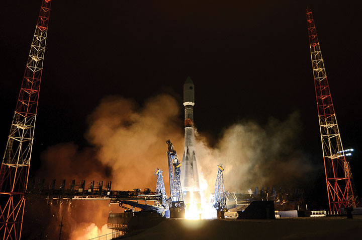
The third generation of GLONASS SC — Glonass-K — was successfully launched from the Plesetsk launch site on Oct. 25. This SC will provide users with a broader range of capabilities — and a more accurate and informative signal in the L3 frequency band. Further gradual rejuvenation of the GLONASS constellation will ensure the ever-improving quality of our navigation services.
Two Glonass-K2 SC are planned for the launch campaign in 2021, and all the experience accumulated during the development of third-generation GLONASS SC (Glonass-K) will be implemented in the fourth-generation SС. Glonass -K2 is a unique SC: It will provide users with five navigation signals, its accuracy will be within 0.3–0.5 m, and its assured expected lifetime will be at least 10 years.
High-Orbit Space Complex
GLONASS developers remain focused on user requirements. Recent surveys show a growing demand for high-quality navigation services in difficult conditions where the SC is visible at more than 25° above the horizon. To satisfy these needs with the implementation of new CDMA signals, development of the GLONASS High-Orbit Space Complex (HOSC) will begin in 2021. Its first SC will be launched in 2025, and complete deployment of the constellation including six SC in three or six planes will be finished by the end of 2027.
As a result, the accuracy and availability of navigation in difficult conditions will improve in the Eastern Hemisphere. But the major anticipated outcome of the HOSC implementation is assured two-fold coverage of the Northeastern segment of the globe with high-accuracy differential navigation data by GLONASS and other GNSS.
HOSC implementation will ensure 25% navigation accuracy improvement over the Eastern hemisphere. Glonass-K SC will be used as a base platform for HASC deployment due to its excellent record.
Ground Control at the Titov Main Test Space Center established a stable telemetry connection with the new satellite shortly after launch. (Photo: Roscosmos)
User Interface Harmony
One of the most important tasks for the year 2020 is harmonization of the GLONASS user interface. As we already mentioned, the signal propagation environment has a strong effect on navigation accuracy; therefore, new issues of GLONASS Interface Control Documents (ICD) are being prepared for publication.
We anticipate that GLONASS end-user accuracy improvement will be achieved through introducing additional information into reserve bits of navigation frames, including relevant parameters of an ionospheric model.
The ICD will contain operating methods with parameters of the ionospheric model and definite recommendations designed for compensation of ionospheric delays by both single-frequency and dual-frequency receivers, as well as generalized methods for compensating for tropospheric delays.
Changes in the ICD concerning FDMA and CDMA signals will ensure backward compatibility and uninterrupted operation for the existing range of user navigation equipment.
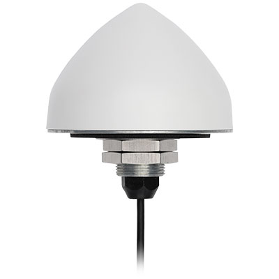
The new TW5382 smart GNSS antenna by Tallymatics Inc. is designed for high-accuracy 5G timing. Tallymatics focuses on GNSS timing antennas; it is a division of the Calian Group of Companies, along with Tallysman Inc.
The TW5382 is a multi-band, multi-constellation 5G smart GNSS antenna/receiver that provides 5 ns (1-sigma, clear sky view) timing accuracy. It consists of two components: a Tallysman GNSS Accutenna technology antenna and a professional-grade GNSS timing receiver module.
Accutenna supports the full bandwidth of the TW5382 receiver, strong multipath mitigation and deep filtering, in a compact IP69K enclosure. These features enable the antenna to provide a strong, pure, in- band, right-hand circular polarized signal to the receiver.
Photo: Tallysman
The TW5382’s professional-grade multi-constellation and multi-signal timing receiver tracks GPS/QZSS (L1/L2), GLONASS (G1/G2), Galileo (E1/E5b), and BeiDou (B1/B2) signals. Dual-frequency GNSS enables the receiver to minimize ionospheric delay and enhances multipath mitigation.
Other key features of the GNSS receiver include support for anti-jamming and anti-spoofing, Timing-Receiver Autonomous Integrity Monitoring (T-RAIM), and GNSS augmentation systems: WAAS (USA), EGNOS (Europe), MSAS (Japan), and GAGAN (India), all of which provide orbit and clock corrections, a well as health and integrity information.
Multi-constellation tracking enables the GNSS receiver to report the Coordinated Universal Time (UTC) estimated by each constellation. The receiver can be configured to output either the GPS, GLONASS, Galileo, or BeiDou realization of UTC. The timing pulse can also be configured to suit the user’s requirements.
The TW5382 supports an RS-485 communication interface, which enables the receiver to be configured and monitored.
Lastly, combining the GNSS antenna and receiver in a single package ensures that each smart antenna will produce precisely the same timing signal, as each smart antenna cable delay will be virtually identical. Only the user’s time pulse cable length (smart antenna to user equipment) will have to be considered, which simplifies the operator’s installation.
Contact Tallymatics for more information concerning the ultra-precise TW5382 High Accuracy 5G Timing Smart GNSS antenna.
Startup Angsa Robotics was named the overall winner of the Galileo Masters 2020 competition for its autonomous rubbish robot.
According to Angsa Robotics, “Clive” is Germany’s first autonomous rubbish robot. It can move independently and detect and localize individual objects based on its unique artificial neural network architecture, which enables it to clean grass and gravel areas. In addition, individual objects such as crown caps or cigarette butts are targeted for collection, but insects are spared.
The robot’s target use cases include cleaning festival venues after events and the daily cleaning of parks and other green spaces. It can be used where conventional sweeping machines designed for flat asphalt surfaces cannot be used, Angsa Robotics said.
Precise localization via GNSS is essential to its operation, Angsa Robotics added. With better localization, “Clive” can plan a more efficient path and clean a given area faster.
“Angsa Robotics is another concrete example of the innovation and applications that GNSS is enabling for the benefits of business, society and the environment,” said Rodrigo da Costa, executive director of the European GNSS Agency (GSA). “The combination of precise GNSS localization with further state-of-the art techniques such as artificial intelligence and robotics captures in a nutshell the spirit of the three challenges in this year’s edition of Galileo Masters.”
The Galileo Masters’ network of 101 partners from 18 countries focuses on the regional implementation of the competition to ensure a high level of diversity while enhancing both job growth potential and regional development opportunities. At the 2020 Space Awards, seven challenge winners were honored by representatives of the European Commission, GSA, the German Aerospace Center (DLR), and the German Federal Ministry of Transport and Digital Infrastructure.
The Galileo Masters, founded by AZO, DLR and the Bavarian State Ministry of Economic Affairs and Media, Energy and Technology, annually awards the best services, products, and business ideas using satellite navigation in everyday life.
A link to the live event will be sent to you two hours before the event. Your personalized event URL will be automatically generated by the ON24 system. To ensure receipt of the email, please whitelist this email address by adding it to your contacts: [email protected].
This presentation will begin at 1 p.m. Eastern / 10 a.m. Pacific / 7 p.m. Central European Time on Thursday, January 21st. A recording will also be sent to you the following day so you can watch it on-demand.
Audience members may arrive 15 minutes prior to live time. If you have any questions, please contact event producer Mackenzie Schoenherr at [email protected].
Originally posted in the Android Developers Blog, the following is reprinted with permission from authors Frank van Diggelen, principal engineer, and Jennifer Wang, product manager, Google.
At Android, we want to make it as easy as possible for developers to create the most helpful apps for their users. That’s why we aim to provide the best location experience with our APIs like the Fused Location Provider API (FLP). However, we’ve heard from many of you that the biggest location issue is inaccuracy in dense urban areas, such as wrong-side-of-the-street and even wrong-city-block errors.
This is particularly critical for the most-used location apps, such as rideshare and navigation. For instance, when users request a rideshare vehicle in a city, apps cannot easily locate them because of the GPS errors.
The last great unsolved GPS problem
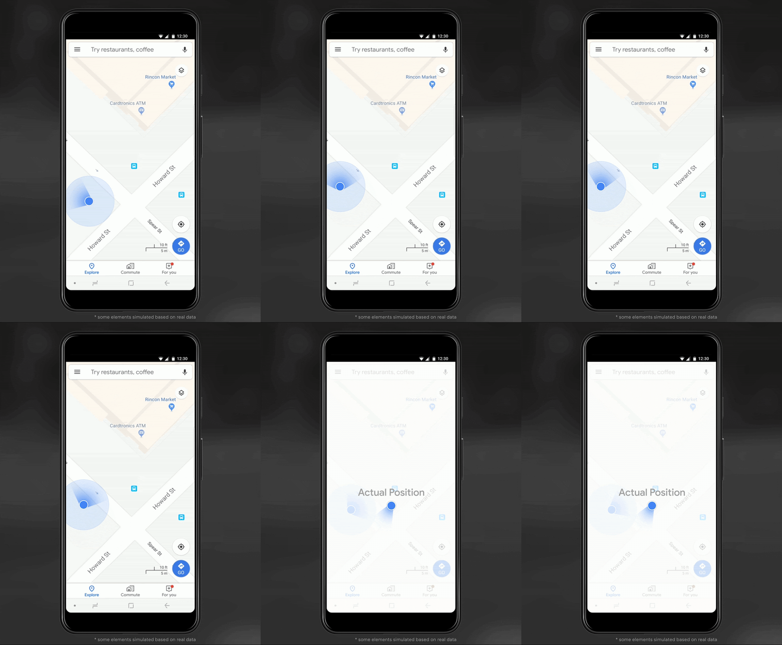
This wrong-side-of-the-street position error is caused by reflected GPS signals in cities, and we embarked on an ambitious project to help solve this great problem in GPS. Our solution uses 3D mapping aided corrections, and is only feasible to be done at scale by Google because it comprises 3D building models, raw GPS measurements, and machine learning.
The December Pixel Feature Drop adds 3D mapping aided GPS corrections to Pixel 5 and Pixel 4a (5G). With a system API that provides feedback to the Qualcomm Snapdragon 5G Mobile Platform that powers Pixel, the accuracy in cities (urban canyons) improves spectacularly.
Image: Frank van DiggelenImage: Frank van Diggelen
Pictures above show a pedestrian test, with Pixel 5 phone, walking along one side of the street, then the other. Yellow = Path followed, Red = without 3D mapping aided corrections, Blue = with 3D mapping aided corrections.
Why hasn’t this been solved before?
The problem is that GPS constructively locates you in the wrong place when you are in a city. This is because all GPS systems are based on line-of-sight operation from satellites. But in big cities, most or all signals reach you through non line-of-sight reflections, because the direct signals are blocked by the buildings.
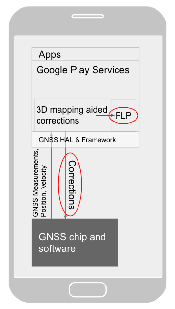
Diagram of the 3D mapping aided corrections module in Google Play services, with corrections feeding into the FLP API. 3D mapping aided corrections are also fed into the GNSS chip and software, which in turn provides GNSS measurements, position, and velocity back to the module. (Image: Frank van Diggelen)Image: Frank van Diggelen
The GPS chip assumes that the signal is line-of-sight and therefore introduces error when it calculates the excess path length that the signals traveled. The most common side effect is that your position appears on the wrong side of the street, although your position can also appear on the wrong city block, especially in very large cities with many skyscrapers.
There have been attempts to address this problem for more than a decade. But no solution existed at scale, until 3D mapping aided corrections were launched on Android.
How 3D mapping aided corrections work
Image: Frank van Diggelen
The 3D mapping aided corrections module, in Google Play services, includes tiles of 3D building models that Google has for more than 3,850 cities around the world. Google Play services 3D mapping aided corrections currently supports pedestrian use-cases only. When you use your device’s GPS while walking, Android’s Activity Recognition API will recognize that you are a pedestrian, and if you are in one of the 3,850+ cities, tiles with 3D models will be downloaded and cached on the phone for that city. Cache size is approximately 20MB, which is about the same size as 6 photographs.
Inside the module, the 3D mapping aided corrections algorithms solve the chicken-and-egg problem, which is: if the GPS position is not in the right place, then how do you know which buildings are blocking or reflecting the signals? Having solved this problem, 3D mapping aided corrections provide a set of corrected positions to the FLP. A system API then provides this information to the GPS chip to help the chip improve the accuracy of the next GPS fix.
With this December Pixel feature drop, we are releasing version 2 of 3D mapping aided corrections on Pixel 5 and Pixel 4a (5G). This reduces wrong-side-of-street occurrences by approximately 75%. Other Android phones, using Android 8 or later, have version 1 implemented in the FLP, which reduces wrong-side-of-street occurrences by approximately 50%. Version 2 will be available to the entire Android ecosystem (Android 8 or later) in early 2021.
Android’s 3D mapping aided corrections work with signals from the USA’s GPS as well as other GNSS: GLONASS, Galileo, BeiDou, and QZSS.
Our GPS chip partners shared the importance of this work for their technologies.
Francesco Grilli, vice president of product management at Qualcomm Technologies Inc.:
“Consumers rely on the accuracy of the positioning and navigation capabilities of their mobile phones. Location technology is at the heart of ensuring you find your favorite restaurant and you get your rideshare service in a timely manner. Qualcomm Technologies is leading the charge to improve consumer experiences with its newest Qualcomm Location Suite technology featuring integration with Google’s 3D mapping aided corrections. This collaboration with Google is an important milestone toward sidewalk-level location accuracy.”
Charles Abraham, senior director of engineering, Broadcom Inc.:
“Broadcom has integrated Google’s 3D mapping aided corrections into the navigation engine of the BCM47765 dual-frequency GNSS chip. The combination of dual frequency L1 and L5 signals plus 3D mapping aided corrections provides unprecedented accuracy in urban canyons. L5 plus Google’s corrections are a game-changer for GNSS use in cities.”
Yenchi Lee, deputy general manager of MediaTek’s Wireless Communications Business Unit:
“Google’s 3D mapping aided corrections is a major advancement in personal location accuracy for smartphone users when walking in urban environments. MediaTek’s Dimensity 5G family enables 3D mapping aided corrections in addition to its highly accurate dual-band GNSS and industry-leading dead reckoning performance to give the most accurate global positioning ever for 5G smartphone users.”
How to access 3D mapping aided corrections
Android’s 3D mapping aided corrections automatically works when the GPS is being used by a pedestrian in any of the 3850+ cities, on any phone that runs Android 8 or later. The best way for developers to take advantage of the improvement is to use FLP to get location information. The further 3D mapping aided corrections in the GPS chip are available to Pixel 5 and Pixel 4a (5G) today, and will be rolled out to the rest of the Android ecosystem (Android 8 or later) in the next several weeks. We will also soon support more modes including driving.
Android’s 3D mapping aided corrections cover more than 3850 cities, including:
North America: All major cities in USA, Canada, Mexico.
Europe: All major cities. (100%, except Russia & Ukraine)
Asia: All major cities in Japan and Taiwan.
Rest of the world: All major cities in Brazil, Argentina, Australia, New Zealand, and South Africa.
As our Google Earth 3D models expand, so will 3D mapping aided corrections coverage.
Google Maps is also getting updates that will provide more street level detail for pedestrians in select cities, such as sidewalks, crosswalks, and pedestrian islands. In 2021, you can get these updates for your app using the Google Maps Platform. Along with the improved location accuracy from 3D mapping aided corrections, we hope we can help developers like you better support use cases for the world’s 2B pedestrians that use Android.
Continuously making location better
In addition to 3D mapping aided corrections, we continue to work hard to make location as accurate and useful as possible. Below are the latest improvements to the Fused Location Provider API (FLP):
Developers wanted an easier way to retrieve the current location. With the new getCurrentLocation() API, developers can get the current location in a single request, rather than having to subscribe to ongoing location changes. By allowing developers to request location only when needed (and automatically timing out and closing open location requests), this new API also improves battery life. Check out our latest Kotlin sample.
Android 11’s Data Access Auditing API provides more transparency into how your app and its dependencies access private data (like location) from users. With the new support for the API’s attribution tags in the FusedLocationProviderClient, developers can more easily audit their apps’ location subscriptions in addition to regular location requests. Check out this Kotlin sample to learn more.
Qualcomm and Snapdragon are trademarks or registered trademarks of Qualcomm Incorporated. Qualcomm Snapdragon and Qualcomm Location Suite are products of Qualcomm Technologies Inc. and/or its subsidiaries.
Reef Support, an automatic warning system that uses artificial intelligence (AI) and satellite imagery to detect coral bleaching, algal blooms, sediment plumes and debris caused by humans, won the Copernicus Masters 2020 competition.
The Reef Support team includes Crystle Wee, Yohan Runhaar, Marcel Kempers, Marijn van der Laan and Eilidh Radcliff.
Reef Support addresses both the environmental and economic aspects at hand with state-of-the art technology. Its user-friendly online monitoring and maintenance tool uses AI and satellite imagery to track coastal reef health and also provides guidelines for crowd and pollution control, debris management and coral restoration.
According to the team, different types of data can be combined to form a picture of reef ecology across a wide range of spatial and temporal scales. The Reef Support platform can be used for strategic planning and resource management in aquaculture farming, as well. Its deep learning algorithm adapts to user applications and regional tendencies.
The subscription-based service is available on both iOS and Android.
Celebrating its 10th iteration in 2020, the international innovation competition Copernicus Masters awarded prizes in 22 categories to outstanding products and services based on Earth observation data. In total, 591 participants from 47 countries submitted 220 new Earth observation business cases and application ideas.
“Copernicus Masters has proven to be the perfect instrument to reach entrepreneurs to become a reality in Earth observation and tackle challenges such as climate change, technology revolutions, shifts in geopolitical power or humanitarian crises, and to support economic growth, safety and security, quality of life and sustainable development,” said Jan Wörner, director general at the European Space Agency (ESA).
AZO launched the Copernicus Masters in 2011 on behalf of the ESA.
Yang Changfeng, chief architect, BeiDou Navigation Satellite System, speaks at an international event. (Photo: BDS)
On July 31, 2020, BDS-3, the global version of the BeiDou Navigation Satellite System (BDS), was formally commissioned, marking the completion of its three-step development process. BDS enters a new era of global services. With the principle of “serving the world and benefiting mankind,” BDS provides seven types of services to users worldwide, including positioning, navigation and timing (PNT) services, a global short-message communication (GSMC) service, a regional short-message communication (RSMC) service, an international search-and-rescue (SAR) service, the BeiDou satellite-based augmentation system (BDSBAS), the BDS/GNSS ground-based augmentation system (BDGAS), and the precise point positioning (PPP) service. BDS has been continuously making contributions to improving GNSS capabilities and promoting the development of GNSS applications and technologies.
In 2020, as BDS construction was successfully completed, BDS has made fruitful achievements in application development and internationalization.
System Construction
Space Constellation Deployment. From March to June 2020, two BDS-3 GEO satellites were launched, while the in-orbit tests of two IGSO satellites, two GEO satellites, and two MEO satellites were completed. As the result, the global system constellation was successfully deployed.
By the end of October 2020, 45 in-orbit operational BDS satellites provide services to global users, including 15 BDS-2 satellites and 30 BDS-3 satellites.
Ground System Development. More than 40 new ground stations have been built, tested and commissioned. The BDS ground system is operating stably, supporting daily BDS operations.
Basic Service Enhancement
Generally speaking, the accuracy of the BDS signal-in-space is better than 0.5 m, BDS global positioning accuracy is better than 10 m, BDS velocity measurement accuracy is better than 0.2 m/s, and BDS timing accuracy is better than 20 ns. In the Asia-Pacific region, BDS positioning accuracy is better than 5 m, the velocity measurement accuracy is better than 0.1m/s, and timing accuracy is better than 10 ns.
In the key service area, there are 30 BDS-3 satellites and 15 BDS-2 satellites that jointly provide the services using B1I and B3I signals. The actual average measured positioning accuracies are about 1.48 m horizontally and 2.99 m vertically (95% confidence), which are improvements of about 30% and 5% respectively as opposed to solely relying on the BDS-2 system.
Globally, with the B1I, B3I, B1C and B2a signals, BDS-3 offers service availability of 100% (PDOP ≤6,). The actual measured positioning accuracies are about 1.54 m horizontally and 2.65 m vertically (95% confidence).
Featured Services Benefit Users
Presently, the BDS PPP service covers China and its surrounding areas. By broadcasting the high-precision orbit and satellite clock error corrections through the B2b signal, the high-precision positioning service is provided, while initial testing measurements show that the positioning accuracies are about 0.18 m horizontally and 0.26 m vertically (95% confidence).
BDSBAS was developed in accordance with International Civil Aviation Organization (ICAO) standards to provide SBAS services with superior accuracy and integrity, enabling aircraft approach with vertical guidance of class I (APV-I). The BDSBAS services cover China and its surrounding areas, and the SBAS data, following ICAO standards are broadcast by the three BDS GEO satellites. In particular, the single frequency SBAS service is being provided through the BDSBAS-B1C signal. At the moment, the civil aviation certification process of the BDSBAS SF service is being prepared. The BDSBAS-B2a signal will provide the Dual Frequency Multiple Constellation (DFMC) SBAS service. BDS has been actively participating in the development process of the DFMC standards and carrying out the verification of the draft DFMC SBAS Standard and Recommended Practices.
BDGAS consists of 155 framework reference stations and nearly 2,200 regional stations in China. The system carries out high-precision applications in many fields, such as surveying and mapping, land resources, earthquake monitoring, transportation and meteorology. Its basic services include real-time positioning at the meter, decimeter and centimeter levels, as well as precise post-processing positioning at the millimeter level.
Being developed in accordance with Cospas-Sarsat standards, the BDS MEO-SAR service provides the detection probability of the international search-and-rescue service of better than 99%, with the characteristic return link capability. In July, a joint test was carried out using the BDS MEO-SAR satellites with the Cospas-Sarsat ground station in Maryland, U.S., and the relevant technical documents and the equipment admittance testing reports were formally submitted to Cospas-Sarsat, which provides Chinese contributions to the international MEO-SAR family.
RSMC provides service to China and its surrounding areas through three GEO satellites. Its communication capability is greatly improved compared to BDS-2. With service capacity of 12 million times per hour, the transmitting power of user terminals is reduced to 1-3 W and the single message capacity reaches 1,000 Chinese characters. The construction of the RSMC service platform has been completed to promote the organic integration of short message and mobile communication services, and to further exert the advantages of the BDS featured services.
GSMC provides global services through 14 MEO satellites with single message capacity of 40 Chinese characters.
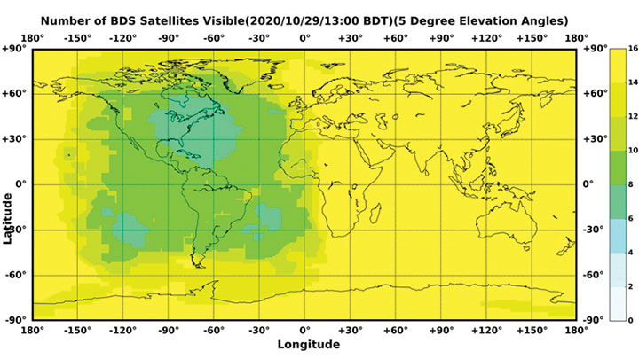
Figure 1. The number of visible BDS satellites as of BDT 13:00, Oct. 29, 2020. The number of visible satellites at Asia-Pacific Region is greater than 20. (Source: www.csno-tarc.cn)
Integrated Applications
As the system construction accelerates, BDS is also making great efforts to strengthen the development of BDS fundamental products and promote large-scale applications in various fields. The integrated applications and innovative development adopt the “BDS+” and “+BDS” models to improve quality and efficiency as well as to stimulate a healthy and fast-growing GNSS industry.
Fundamental Products. At present, the fundamental BDS products have been used in areas such as mass-market applications, where the performance has reached or is close to the world-class level. Progress has been made in the research and development of multi-system baseband-RF integrated high-precision chips. The 28 nm chips have been mass-produced, and the 22 nm chips are about to be mass-produced. As a result, the function and performance of the chips will reach a new level. The BDS navigation chips, modules, high-precision boards and antennas have been exported to more than 120 countries and regions, serving millions of users worldwide.
Industrial Applications. BDS has been widely used in various fields, including communication and transportation, public security, agriculture, forestry, animal husbandry and fishery, hydrological monitoring, meteorological forecasting, time synchronization, power dispatching, and disaster prevention and mitigation. Significant economic and social benefits have been generated.
In the field of transportation, in the first three quarters of 2020, more than 7 million road vehicles were using BDS. The number of postal and express delivery vehicles using BDS reached 314,000, and the number of ships is about 1,369. In general aviation, 300 planes are using BDS.
In agriculture, BDS-based automatic steering systems are on more than 45,000 pieces of agricultural machinery and equipment, saving 50% of the labor cost. BDS-based agricultural machinery operation supervision platforms are serving 10 million units of agricultural machinery equipment, greatly improving management and operational efficiency.
In forestry, the BDS positioning and short message communication services are widely used in forest fire prevention, natural forest protection, forest inspection, pest control and so on.
In the fishery field, BDS provides fishery managers and fishing vessels with ship position monitoring, emergency rescue, information dissemination, vessel management and other services. BDS terminals have been installed on more than 70,000 fishing boats and law enforcement vessels in China. More than 10,000 people have been saved.
For disaster prevention and mitigation, a three-level platform covering the national ministries and the provinces was built to offer six-tier application services, deploying more than 45,000 BDS terminals.
BDS plays an important role in the emergency response to major disasters such as flooding in South China and forest fire in Southwest China this year. BDS is accelerating entry into new infrastructural construction, and is deeply integrated with new technologies such as next-generation communication, blockchain, the internet of things, artificial intelligence, and more. New modes, formats and markets for BDS applications are constantly emerging.
Mass-Market Applications. BDS-based navigation and positioning services have been adopted by various enterprises in the fields of e-commerce, smart mobile terminals, location-based services, the sharing economy and people’s livelihood, profoundly changing people’s production and lifestyles. Just like water and electricity, BDS provides public services that are easily accessible and available on demand. In smartphone applications, domestic and international mainstream chip manufacturers have released communication-navigation integrated chips compatible with BDS. More than 90% of mobile-phone companies applying for access to China’s domestic network support BDS positioning. Smartphones from Huawei, MI, Apple, VIVO, OPPS and other big brands in China are BDS-enabled.
BDS Standards. The updating and upgrading of the BDS standard system is progressing smoothly, with Version 2.0 to be released soon. The BDS application standard systems will be published in electric, railway and other industries. The revision of the national BDS standards is advancing steadily. Four national standards were issued in early 2019, and 28 national standards will be released by the end of 2020. Forty-two standards related to the BDS program have been issued in three batches, while 58 new standards are being formulated.
The work related to BDS intellectual properties is being carried out, and various innovation entities continue to improve BDS’ intellectual property creation, utilization and protection capabilities. Statistics shows that Chinese GNSS-related patent applications reached 12,170 in 2019 and 9,411 by the end of October, with an average growth rate of 21.7% in the past three years.
International Cooperation
Bilateral Cooperation. BDS continues to carry out bilateral cooperation with other GNSS to promote compatibility, interoperability and joint applications. Under the China-U.S. civil GNSS cooperation platform, working groups have been set up to continuously engage in cooperation and exchanges in areas such as compatibility and interoperability, augmentation systems and aviation applications, civil service provisions, etc. China and the Russian Federation held their seventh bilateral meeting in October, and have been pushing forward landmark demonstration projects such as joint ground station set-up, cross-border transportation and precision agriculture. China and the European Union are carrying out coordination, exchanges and cooperation under the framework of the China-EU space cooperation dialogue.
Multilateral Cooperation. The BDS team participates in meetings of the International Committee on Global Navigation Systems (ICG), and continuously promotes discussions on relevant topics. The experience fighting COVID-19 using BDS/GNSS, as well as BDS applications in pandemic prevention and control, are being shared with the international GNSS community. During the ninth ministerial meeting of the China-Arab States Cooperation Forum held in July, video conferences promoted the deepening of China-Arab satellite navigation cooperation.
International BDS Applications. With the export of BDS high-precision products, BDS is widely used in different regions and fields, such as land registration, precision agriculture, warehouse logistics in ASEAN countries, construction in Western Asia, airport timing and plying the seas in South Asia, power plant inspections in Eastern Europe, and land surveys in African countries. BDS high-precision products are exported to more than 120 countries and regions. BDGAS technologies and products are systematically exported, serving more than 100 million users worldwide.
International Standards. BDS has been adopted by many international organizations including the ICAO, the International Maritime Organization, Cospas-Sarsat and mobile communication. A number of international standards supporting BDS have been released. In March, the International Electrotechnical Commission (IEC) officially issued the first international standard for BDS vessel receiving equipment inspection (IEC 61108-5), which provides the basis for global classification societies to carry out type certification of BDS equipment on vessels. In July, the first batch of 3GPP standards supporting the BDS B1C signal was officially released. The series of standards will support BDS signals in Assisted GNSS (A-GNSS) of 5G communication. By year’s end, the Radio Technical Commission for Maritime Services (RTCM) 10403.X standard, which fully supports BDS, will be officially released, marking an important milestone in the creation of a general data format standard for BDS receivers.
Adhering to the development concept of “the Chinese BDS, the World’s BDS and the First Class BDS,” BDS development vigorously carries forward the Beidou spirit in the new era — independent innovation, open integration, unity and pursuit of excellence. By 2035, a more ubiquitous, integrated and comprehensive national PNT system with a spatial-temporal information service infrastructure covering space, sky, Earth and sea, and offering unified high precision, high intelligence, high security and high efficiency, will be built. It will provide core support for future intelligent and unmanned development; continuously promote system upgrading; integrate new technologies such as new generation communication and low orbit augmentation; strive to develop high-quality capabilities such as quantum navigation, full-source navigation, and micro PNT; and build a spatial-time information service infrastructure covering space, sky, Earth and sea, with high precision, high intelligence, high security and high efficiency.