The U.S. Coast Guard Navigation Center has issued a notice that GPS satellite SVN-77 (PRN-14) was set healthy for initial use on Dec. 2 at 0131Z. This follows the U.S. Space Force announcement that the satellite, the fourth GPS III (SV04), received Operational Acceptance approval on Dec. 1.
SVN-77 is the 23rd satellite to broadcast L2C, the second civil GPS signal at 1227.6 MHz. L2C is not yet designated as “operational” by the U.S. Space Force.
However, the L2C signal is set to healthy, and users can utilize this signal at their own risk.
The U.S. Air Force’s Lockheed Martin-built next generation GPS III satellite on orbit. Rendering portrays GPS III Space Vehicles (SVs) 01-10. (Artist’s Rendering: Lockheed Martin)
SVN-77 is the 16th satellite to begin broadcasting the third civil GPS signal, L5, specifically designed for aviation use in an internationally protected band of spectrum designated for aeronautical navigation at 1176.45 MHz. L5 continues to broadcast an unhealthy designation.
SVN-77 is the fourth satellite broadcasting the new L1C signal at 1575.42 MHz.
The next GPS III satellite, SVN-78, initially scheduled to launch in January, will launch no earlier than July 1, 2021.
The Royal Institute of Navigation (RIN) has issued a call for papers for the Navigation 2021 conference.
The conference, which as of now will be held virtually Nov. 15-18, 2021, will bring together experts from industry, research institutions, government agencies and investors whose primary goal is to work together for a more navigable world, RIN said. Conference themes will include PNT systems and technology, robust PNT, PNT applications, animal and human navigation, and navigation in society.
The November 2021 event will unite two established conferences: the International Navigation Conference and the European Navigation Conference.
RIN is accepting papers in the following categories:
Peer-reviewed: Abstracts and, if accepted, papers will be peer reviewed and published to be indexed and searchable. Presentations will be invited in a parallel technical session at the conference.
Presentation: Abstracts will be reviewed and, if accepted, submitters will be invited to present their work in a parallel session at the conference.
Poster: Abstracts will be reviewed and, if accepted, posters will be displayed in the exhibition hall. RIN plans to encourage delegate interaction through poster presentations during the networking sessions.
The best peer-reviewed papers will be invited to submit for consideration to be published in the Journal of Navigation, RIN added.
Navigation 2021 will take place as a virtual conference. According to RIN, it will review the situation in 2021 and if possible run an in-person element to compliment the conference.
The fourth GPS III satellite, space vehicle (SV) 04, received United States Space Force’s Operational Acceptance approval on Dec. 1.
Operational acceptance marks another significant milestone for the GPS III program, Space and Missile Systems Center and USSF, according to the Space Force. This is the fourth GPS III satellite delivered into the operational constellation in the past 12 months and the second in the past three months.
Also, this is the first GPS III vehicle delivered to the warfighter through an expedited satellite control authority transfer process, which cuts 10 days off the previous operational acceptance timeline.
One more to go for M-code capability
“With the onset of SV04, the GPS constellation continues moving forward in next generation modernization,” said Capt. Collin Dart, the 2 SOPS DOA flight commander. “The 2nd Space Operations Squadron is one step closer to providing military code (M-code) capability for the entire 24 satellite baseline.”
“The highly encrypted M-code to protect GPS signals from jamming and spoofing is currently enabled on 22 GPS satellites of various generations; 24 are needed to bring the M-code to the next level of operational capability,” Dart explained. “SV04 brings the constellation to 23 M-code capable vehicles. SV05 will launch no earlier than July 2021. This will add the 24th M-code capable vehicle.”
“M-code signals are more-secure, harder-to-jam and spoof, and are critical to helping our warfighters complete their missions, especially in contested environments,” said Tonya Ladwig, Lockheed Martin’s vice president for Navigation Systems. “GPS III is a warfighting system and we are proud to be helping bring this critical capability to the men and women protecting our nation.”
GPS III SV04 is encapsulated in its protective launch fairings. (Photo: 45th Space Wing Public Affairs)
Faster handover from contractor
SV04 also sets a new standard for handover from contractor Lockheed Martin’s launch team to operational acceptance, setting the satellite healthy to the global user community approximately 30 days post launch, according to Dart. “Moving forward with future GPS III launches, the timeline between launch and the satellite being set healthy will be at a minimum,” he said.
SV04 was launched on a SpaceX Falcon 9 Block 5 vehicle on Nov. 5. The Air Force has been flying 31 operational satellites for years to ensure the United States’ commitment to have 24 operational GPS satellites available 95% of the time.
GPS III SV04 joins this operational constellation of 31 GPS satellites orbiting in medium-Earth orbit. The system delivers improved accuracy, advanced anti-jam capabilities and increased resiliency for the GPS III constellation.
Lockheed Martin’s production proceeds
The Space Force declared GPS III SV05 “Available for Launch” in May. The satellite is waiting to be called up”for launch.
GPS III SV06, 07 and 08 are now fully assembled and going through environmental testing at Lockheed Martin’s GPS III Processing Facility in Denver.
GPS III SV09 and 10 are in component build up.
Lockheed Martin is also under contract for up to 22 additional GPS III Follow On (GPS IIIF) satellites, which introduce further technology and capabilities. In May, Lockheed Martin completed its Critical Design Review for the GPS IIIF and in July, the Space Force declared that GPS IIIF fulfilled “Milestone C,” which means the production phase of the program has officially begun.
“The operational acceptance of GPS III SV04 is another significant milestone for GPS Modernization, delivering critical new capabilities to our Military and Civil Users. We now have a total of 23 M-code spacecraft for our Warfighters. For our billions of civil users, it brings the count up to 23 L2C spacecraft and 16 L5 spacecraft,” said Col. Ryan Colburn, director of the SMC Portfolio Architect Office’s Spectrum Warfare Division. “For professional users with existing dual-frequency operations, L2C enables faster signal acquisition, enhanced reliability, and greater operating range. L5 is broadcast in a radio band reserved exclusively for aviation safety services. It features higher power, greater bandwidth, and an advanced signal design. Future aircraft will use L5 in combination with L1 C/A to improve accuracy (via ionospheric correction) and robustness (via signal redundancy). The operational acceptance of this spacecraft is another display of the fantastic teamwork across SMC’s Corps, Space Delta 8, National Geospatial-Intelligence Agency, Department of Transportation, Federal Aviation Administration, our industry partners and many others who work together to make these missions possible.”
GPS satellites provide position, navigation, and timing to more than four billion military and civilian users worldwide.
A Falcon 9 carrying GPS III SV04 lifts off from Cape Canaveral Air Force Station, Florida, Nov 5. (Photo: SpaceX via USAF)
Japan’s Quasi-Zenith Satellite System (QZSS) CLAS received a major enhancement on Nov. 30. QZSS CLAS (centimeter-level augmentation service) is the satellite-based nationwide open PPP-RTK service in Japan, providing centimeter positioning accuracy within one minute.
With the introduction of a new, highly efficient atmospheric correction message, the number of available satellites will be increased to 17 for those using CLAS. GPS, Galileo and QZS satellites in view will be corrected by the QZS L6 signal.
“The performance is expected be improved considerably, especially in urban areas,” said Rui Hirokawa, the deputy general manager, Space Systems Department of Mitsubishi Electric Corporation, Kamakura Works, in an email to GPS World.
Compact SSR — a highly efficient RTCM-compatible open specification for PPP/PPP-RTK — is applied to QZS CLAS. Compact SSR is accepted as a PPP-RTK standard in the 3GPP LTE positioning protocol (LPP) and the mobile communication standard for LTE/5G, with plans for it to be applied to the Galileo High-Accuracy Service (HAS).
Since July 1, CLAS has been broadcasting a trial signal compliant with IS-QZSS-L6-003 using the L6D signal of QZS-3, which increases the number of augmented satellites to a maximum of 17 for more stable positioning accuracy.
On Nov. 30 (JST), the official broadcast of the augmentation information began from all four QZS satellites (QZS-1, 2, 3 and 4).
To continue using CLAS after Nov. 30, it may be necessary to update the receiver’s F/W to comply with IS-QZSS-L6-003. Please contact the manufacturer of the CLAS receiver for further information. Read more in this National Space Policy Secretariat notice.
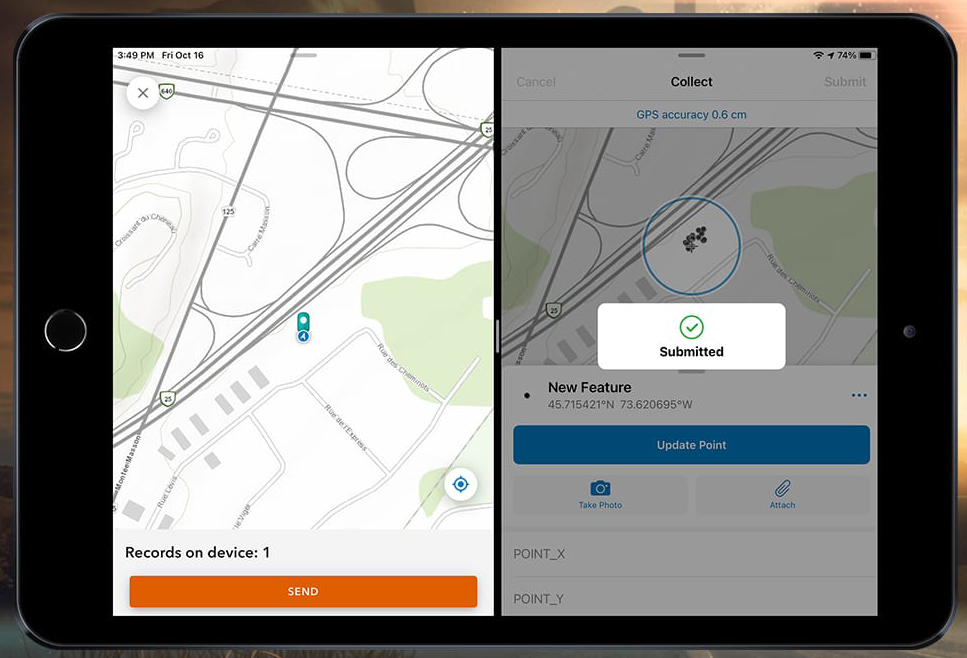
Eos Positioning Systems Inc. (Eos) has released capability in its Eos Tools Pro apps (iOS, Android, Windows) that allows Esri Collector for ArcGIS and Survey123 to run concurrently, allowing the user to dynamically switch between the two apps in the field.
“Without this capability, users could not run two data-collection apps, such as Collector and Survey123, or ArcGIS Field Maps and ArcGIS QuickCapture, at the same time,” Eos Chief Technology Officer Jean-Yves Lauture said. “With this release, parties can run multiple apps on a single device that simultaneously consume high-accuracy positioning data from the Arrow GNSS receiver.”
This new capability allows fieldworkers to run two apps at the same time while accessing the same ArcGIS Online database. Specifically, a user can now record a high-accuracy GNSS location in Collector and then immediately switch to an open Survey 123 form to complete their workflow. The data, including precise positioning will be populated to the same ArcGIS Online database.
“Eos is excited to enable its users with this unique capability to extend Esri mobile apps,” Lauture said. “Esri users have been asking us about combining Collector and Survey123 data collection for quite some time, and we are happy to further increase their high-accuracy data collection efficiency.”
My last column described a new National Geodetic Survey (NGS) webtool for obtaining geodetic information about a passive mark in their database. The column highlighted some features that may be of interest to GNSS users. It provides all of the information about a station in a more user-friendly format. This column highlights an ArcGIS web application that incorporates various California specific datasets and NGS data layers to assist surveyors planning vertical control surveys. The GNSS Leveling Web Application was provided to me by Jay Satalich, chief, Office of Surveys, Caltrans (see box titled “Linkedin Notification from Jay Satalich).
Linkedin Notification from Jay Satalich
Supervising Transportation Survey (Chief, Office of Surveys) at State of California, Department of Transportation:
“GNSS Leveling Web Application” [is] an Esri ArcGIS online web app created for my “GNSS Leveling” students at College of the Canyons. Designed as a practical tool when planning vertical control surveys using GNSS. National datasets include: National Spatial Reference System (layers: satellite visibility, stability, and vertical control source), geology, and GEOID18 (layers: GEOID18 height, difference between GEOID18 and GEOID12B, and GEOID18 uncertainty). California-specific datasets include: oil/gas/fracking/injection wells, fault lines, oil fields, groundwater basins, and landslide areas. The NOAA National Geodetic Survey data layers were created and published by Brian Shaw. People who influenced development of this app include Dave Zilkoski, Kevin M Kelly, Ken Hudnut, David D Jackson, Ross S. Stein, and Arthur Sylvester.
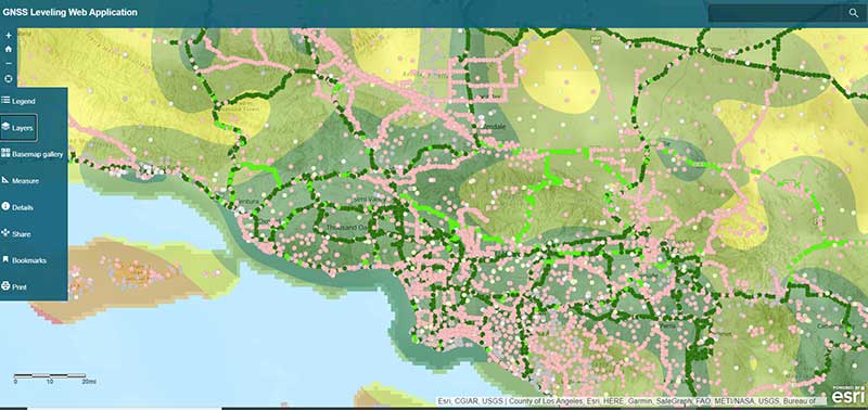
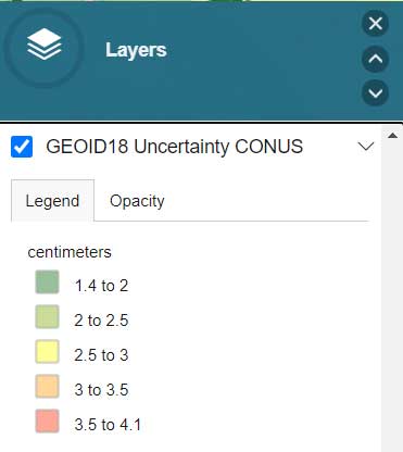
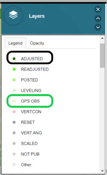
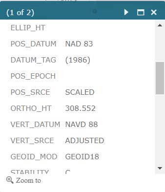
The box titled “GNSS Leveling Web Application” depicts a map of the Los Angeles area that provides the list of published marks in NGS’ database with an overlay of the uncertainty of NGS’ hybrid geoid model GEOID18. Plotting the published marks from NGS’ database is very useful for surveyors reconning marks for a GNSS survey project. The attributes allow users to quickly identify stations that have published heights from leveling adjustments projects (labeled as ADJUSTED) and those that have heights published from GNSS adjustments projects (labeled as GPS OBS). (See here for definition of attributes.)
Source: Esri ArcGIS GNSS Leveling Web ApplicationSource: Esri ArcGIS GNSS Leveling Web Application
Source: Esri ArcGIS GNSS Leveling Web Application
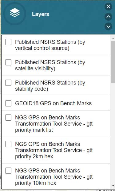
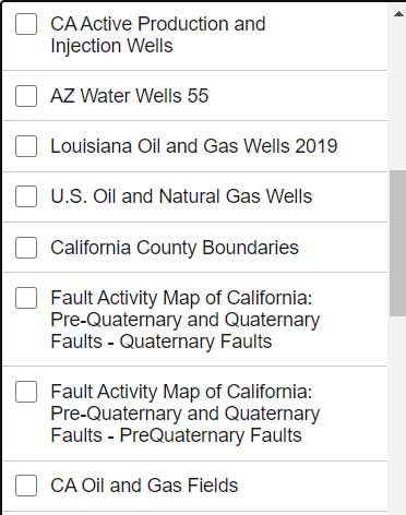
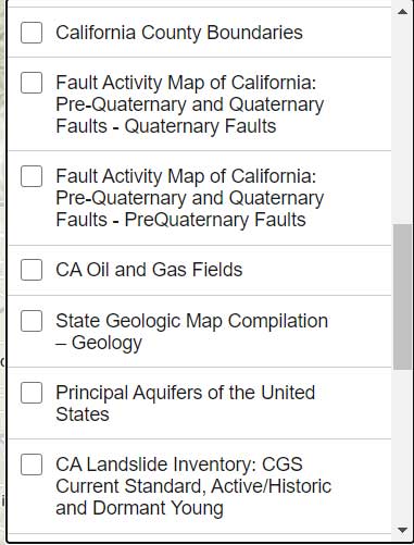
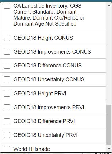
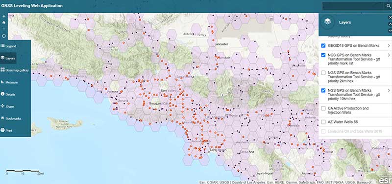
The list all of the layers of the web application are provided in the box titled “GNSS Leveling Web Application Layers.” (Note: After you open up the web application, click on the Layers icon to obtain the list of available layers.)
GNSS Leveling Web Application Layers
Source: Esri ArcGIS GNSS Leveling Web ApplicationSource: Esri ArcGIS GNSS Leveling Web ApplicationSource: Esri ArcGIS GNSS Leveling Web Application
Source: Esri ArcGIS GNSS Leveling Web Application
As you can see from the list of layers, the web application enables users to select the layers that are pertinent to their survey project requirements. The application is designed for California surveyors but the concept is transferable to other States. For example, the following layers are not just for California surveyors: Arizona water wells, Louisiana oil and gas well, U.S. oil and natural gas wells, Principal Aquifers of the United States, and, of course, all of the NOAA NGS data layers.
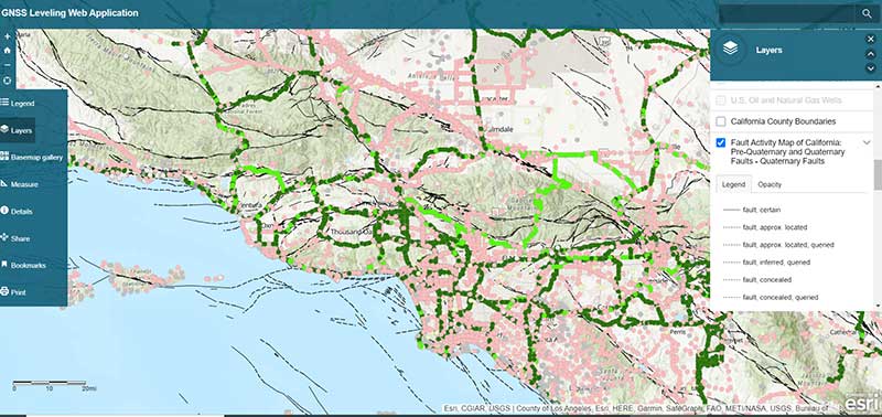
One layer that is very important to California users is the layer that provides the fault activity in their region. The box titled “Fault Activity Map of California: Pre-Quaternary and Quaternary Faults – Quaternary Faults” depicts the list of published marks in NGS’ database with an overlay of the fault activity map.
Fault Activity Map of California: Pre-Quaternary and Quaternary Faults — Quaternary Faults
Source: Esri ArcGIS GNSS Leveling Web Application
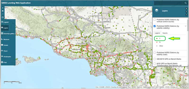
Another great feature of the application is that it has a layer providing the satellite visibility code for published NSRS marks (see the box titled “Published NSRS Stations (by satellite visibility”). Once again, a great feature for field personnel performing reconnaissance.
Published NSRS Stations (by satellite visibility)
Source: Esri ArcGIS GNSS Leveling Web Application
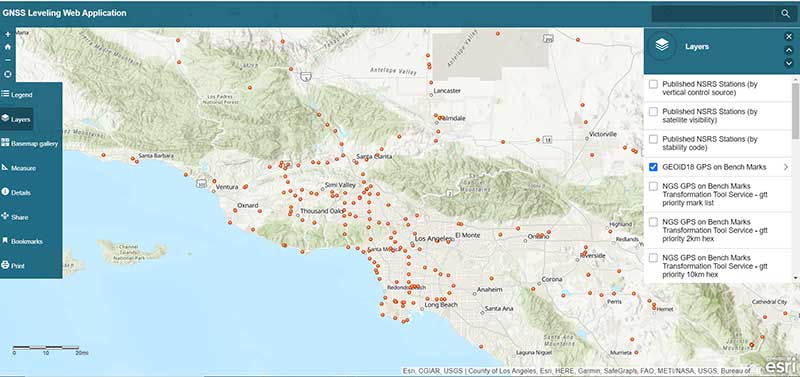
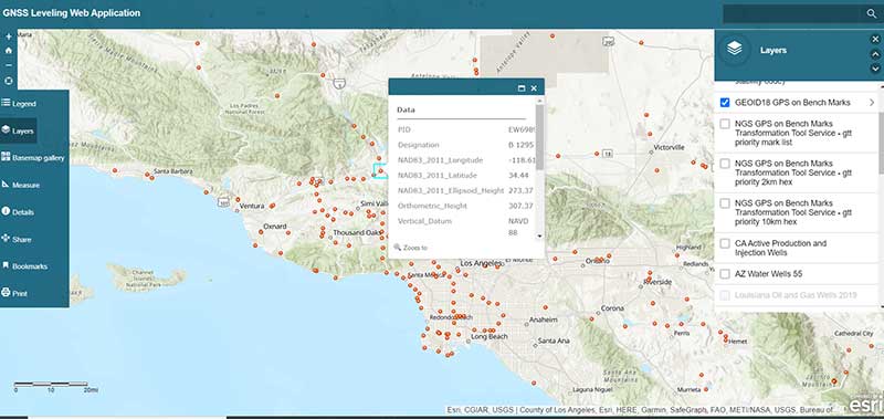
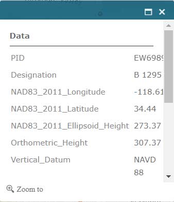
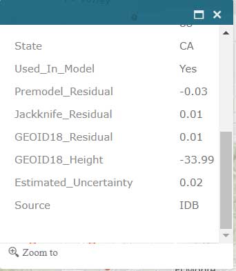
The application also has a feature that lists the marks that were involved in the development of NGS’ hybrid geoid model GEOID18. (see the box titled “GNSS Leveling Web Application GEOID18 GPS on Bench Mark Layer”). Clicking on a mark’s icon provides information and statistics about the mark (see boxes titled “GEOID18 GPS on Bench Mark Layer — PID EW6989” and “Information for GPS on Bench Mark for PID EW6989”). This is one of the layers that provides information for the entire CONUS region. All this information is available from NGS’ website but this application incorporates all of NGS’s data as well as the local information in one application. This web application is very useful to a surveyor planning a survey project and/or providing information to a field reconnaissance team.
GNSS Leveling Web Application GEOID18 GPS on Bench Mark Layer
Source: Esri ArcGIS GNSS Leveling Web Application
GEOID18 GPS on Bench Mark Layer — PID EW6989
Source: Esri ArcGIS GNSS Leveling Web Application
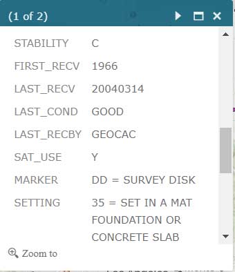
Information for GPS on Bench Mark for PID EW6989
Source: Esri ArcGIS GNSS Leveling Web Application
Source: Esri ArcGIS GNSS Leveling Web Application
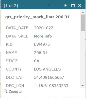
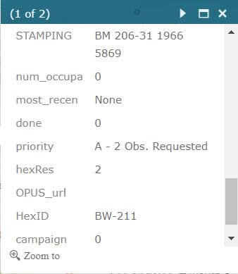
Users that are participating in NGS’ GPS on Bench Mark program can click on the layer for “NGS GPS on Bench Marks Transformation Service Tool, priority 10 km hex” to determine marks that need to be occupied by GNSS to improve a transformation tool being developed by NGS. See boxes titled “NGS GPS on Bench Marks Transformation Service Tool, priority 10 km hex” and “Information for GPS on Bench Mark Priority List for PID EW6989.” There’s also layers that depict the priority mark list for the GPS on Bench Marks program (“NGS GPS on Bench Marks Transformation Tool Service — priority mark list”) and the 2 km hexagon priority grid (“NGS GPS on Bench Marks Transformation Tool Service — priority 2km hex”).
NGS GPS on Bench Marks Transformation Service Tool, priority 10 km hex
Source: Esri ArcGIS GNSS Leveling Web Application
Information for GPS on Bench Mark Priority List for PID EW6989
Source: Esri ArcGIS GNSS Leveling Web ApplicationSource: Esri ArcGIS GNSS Leveling Web ApplicationSource: Esri ArcGIS GNSS Leveling Web Application
Source: Esri ArcGIS GNSS Leveling Web Application
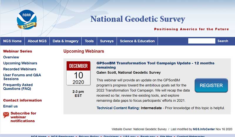
Individuals interested in participating in NGS’ GPS on Bench Mark program should register for NGS’ Dec. 10 webinar, which will discuss the status of the program. See the box titled “GPSonBM Transformation Tool Campaign Update — 12 months remaining” for the information on the webinar. Users can register for the webinar here. I would encourage all users to access the web application tool developed by Jay and/or NGS’ website before participating in the next NGS GPS on Bench Mark webinar.
Almost all of my columns have focused on establishing accurate GNSS heights. Most of my 45 years of working in the field of geodesy has been focused on heights; that is, leveling-derived orthometric heights, GNSS-derived orthometric heights, and geoid heights. Gravity is very important to estimating all of these types of heights. Recently, a colleague sent me a video proving Galileo’s famous gravity experiment. It’s an older video (November 2014), but it’s really fascinating. You can see the entire video here. Another individual pointed me toward the same experiment performed on the Moon during the Apollo 15 mission. What’s amazing to me is that over 400 years ago an individual spent time studying the effects of gravity and developing the concept of acceleration due to gravity. I wonder what the world would look like today if Galileo would have just accepted Aristotle’s theory of gravity (which states that objects fall at speed proportional to their mass) and decided to focus on other tasks. Saying that, I am amazed that most geospatial users do not realize the importance of gravity (and physical geodesy) in the development of the geospatial products and services that they use daily; and, how critical it is that more research is required to meet future geospatial needs. The advancements in satellites and computers have enabled geodesy to expand into many different disciplines. Geodetic science and technology now underpin many sciences, large areas of engineering (such as driverless vehicles and drones), navigation, precision agriculture, smart cities, cellular telephones, and location-based services. (See the GPS World First Fix column about the shortage of American geodesists).
When I end one of my presentations, I always emphasize that Geodesy Provides the Foundation for all Geospatial Products and Services, and Integrated and Collaborative Organizations Create Geospatial Solutions. Geodesy is just as important today as it was 400 years ago.
I hope everyone stays safe during this COVID-19 pandemic and enjoys the holidays.
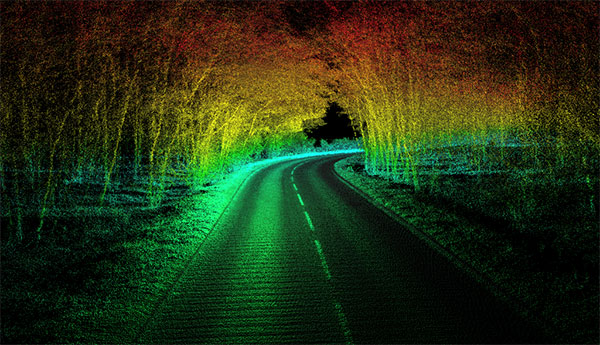
The OxTS Georeferencer combines INS and point-cloud data from third-party lidar sensors. (Image: OxTS)
OxTS is offering its new OxTS Georeferencer, a powerful lidar georeferencing software tool. OxTS Georeferencer combines OxTS inertial navigation data with raw lidar data to give surveyors the ability to create georeferenced point clouds along with tools to calibrate their setup and analyze the accuracy of their surveys.
Users can now combine data from their OxTS inertial navigation system (INS) with a much broader range of lidar sensors. The OxTS Georeferencer works with pointclouds from Hesai, Ouster and Velodyne lidar sensors. New sensors brought to market can be quickly and easily added to OxTS Georeferencer.
This release ensures that surveyors can easily and confidently use OxTS Inertial Navigation Systems and OxTS Georeferencer, to produce georeferenced point clouds irrespective of the LiDAR scanner they prefer to use.
The OxTS Georeferencer gives surveyors flexibility in terms of the hardware they may use to survey their environment.
Users can combine OxTS INS data with data from the following models:
Velodyne. VLP-16 Puck, Puck LITE (beta), VLP-32C (beta) and Alpha Prime VLS128 (beta). The Velodyne VLP-32C sensor is single-return mode only.
Hesai. Pandar40P
Ouster. All Ouster Gen2 lidar, The OS1 and OS2 lidar with 32, 64 and 128 lasers (all Ouster integrations, other than the OS1-64 in uniform laser distribution, are in beta.)
Features of this release include:
Improved calibration. Take advantage of a broader range of set-ups without extensive planning and set-up costs. A data-driven calibration technique helps to get the best results from your set-up. It eliminates blurring and double-vision, especially at longer distances. The new version now can calibrate angles AND linear displacements. Please note that LIP calibration is in beta.
Error estimation. Gain more control over your point-cloud. The new pointcloud error estimation uses a sophisticated formula together with OxTS navigation data diagnostics. These are then used to estimate the centimetre uncertainty in point positions. Users can then choose a maximum uncertainty to be included or remove inaccurate points.
Dual return. Provide customers with enhanced point-cloud images. The new version of OxTS Georeferencer includes dual return capability for nearly all supported models. Where available, this will give point clouds much higher definition. Users can then present enhanced point-cloud images to customers and internal stakeholders as well as service specific applications.
Easily integration of new lidar families. This latest version of OxTS Georeferencer supports the future proofing of other new LiDAR sensors. It allows users to quickly and simply add new LiDAR families to the framework. If there are any LiDAR sensors NOT currently integrated that you want to see, contact OxTS and they will consider them.
For more information on OxTS Georeferencer or to arrange a demonstration, contact OxTS – OxTS Georeferencer.
The University of Colorado – Denver has received a significant gift from Trimble to establish a state-of-the-art technology lab for the College of Engineering, Design and Computing.
The gift will also support the departments or programs in construction engineering and construction management, geography and environmental sciences, physics, and urban and regional planning. The lab will expand the university’s access and expertise in a customized suite of construction hardware and software products.
Trimble’s broad Connected Construction portfolio enables professionals along the project lifecycle to accelerate project processes — improving productivity, quality, transparency, safety and sustainability, while reducing waste.
The Trimble Technology Lab will provide students enrolled across relevant programs hands-on experience with a wide breadth of Trimble solutions. The lab will expand the university’s access and expertise in project management, architectural and structural analysis, design and engineering, mixed reality, 3D scanning, office-to-field solutions, and GIS data collection and GNSS positioning.
Partnering with Trimble allows the University of Colorado – Denver to integrate the latest technology into its curricula, empowering graduates to rapidly transform how buildings and living environments are designed and constructed.
The lab will include a broad range of Trimble’s technologies.
Hardware includes the Trimble XR10 HoloLens with hardhat, TX8 3D laser scanner, Trimble SiteVision AR system, R12 GNSS systems, Juno 5D handheld scanner, Geo 7x mobile GNSS data collectors, robotic total stations and field tablets.
Software solutions include RealWorks scanning software, Trimble Business Center, Tekla Structures, Tekla Structural Designer, Tekla Tedds, Trimble Connect, ProjectSight, Viewpoint, TILOS, Trimble Positions Desktop, TerraSync and TerraFlex, eCognition, and the company’s 3D modeling software, SketchUp Pro.
“CU Denver is right in our backyard, providing an exciting opportunity to integrate our industry-leading technologies into a wide range of educational programs. Their proximity enables us to work closely while ensuring easy access, training and support, and success in all aspects of implementation,” said Allyson McDuffie, director of Education & Outreach at Trimble. “Trimble’s education and outreach programs aim to support the next generation of influencers by actively working with key education institutions to ensure Trimble’s portfolio of solutions are accessible and implemented in higher education curricula and research programs, creating a new workforce equipped and empowered to ‘Transform the Way the World Works.’”
Martin Dunn, dean of the College of Engineering, Design and Computing, said, “I am thrilled with and grateful for this exciting relationship with Trimble. It will accelerate our strategic vision to educate diverse graduates who will not only make an immediate impact in the AEC industry, but will emerge as its future leaders. The generous gift will have broad impact across our campus, nucleating the kind of interdisciplinary collaboration among engineers, architects, construction managers, and scientists that is needed to create and exploit technological innovation to address grand challenges facing the built environment including digital transformation, sustainability, and the future of work and the workforce.”
“Our students and faculty could not be more excited to have access to Trimble technologies. Trimble is a company of international importance, which is also right down the road from our campus. In establishing this new lab, our students will be exposed, either virtually or on-site, to cutting edge products and innovation as well as benefit from direct access to the many professionals in Trimble’s worldwide network. Trimble is exactly the type of company that gets our students excited about pursuing careers in construction and engineering,” said Caroline Clevenger, associate professor and director of Construction Engineering and Management.
Funding from SPRINT will enable Route Masters to collaborate with the University of Leicester on building a full suite of technology tools and algorithmic data models. This will help the company to achieve its aim of becoming the largest integrated public-transport platform for emerging African megacities.
Route Masters is developing an algorithm based on single-band GNSS positioning within cities. The solution will deliver transport flow models superimposed on satellite-based city maps. The technology utilizes applied mathematics to build digital route maps that will accurately deliver journey times and modes for city planning tools and mobile navigation applications for consumers.
This data fusion project will combine dual-band GNSS with single-band GNSS and satellite derived city maps. The solution will be leveraged to deliver planning and control intelligence services and consumer services and, after University of Leicester validation, it will be tested and deployed as an active prototype in Lagos, Nigeria.
The University of Leicester will provide Route Masters with expertise in algorithms and software development for data driven space projects as well as high-performance computational (HPC) facilities.
The project will be funded by a grant from the £4.8 million SPRINT programme that provides unprecedented access to university space expertise and facilities. SPRINT helps businesses through the commercial exploitation of space data and technologies.
“We’re a highly ambitious sustainable business with the goal of creating the largest technology-enabled data platform for transport on the African continent,” Meir Wachs, CEO of Route Masters, said. “The support of SPRINT will enable us to develop our technology in specific areas, working with the Leicester mathematics school to accelerate our development in certain key areas and to build a robust and rigorous solution that can make an actual impact on the world.”
“Projects such as this SPRINT one with Route Masters are of great benefit to the university as they enable us to engage with vibrant companies and transfer our knowledge into commercial innovative applications,” added Alberto Paganini, Lecturer in Applied Mathematics at the University of Leicester.
“We’re bringing advanced mathematical methods, data analysis and software development to the project, not only supporting the commercial development of Route Masters’ technology but also allowing us to integrate the insight gained into our curriculum to further enhance the employability skills of our students.”
Muyiwa Omopariola, Lead Transport Analyst at the Lagos Metropolitan Area Transport Authority (LAMATA) also expressed his support for the project, noting, “I greatly support technology innovation in the transport sector, especially in Lagos and across the emerging world. We look forward to seeing their continued progress.”
Drivers will now be able to enter what3words addresses directly into their in-car systems, allowing them to navigate to any destination
Image: HERE
HERE and what3words have partnered up to offer the next generation of precision in-car navigation. OEMs using HERE Technologies can now include what3words as an in-car navigation feature, with drivers of enabled vehicles able to navigate to any precise 3-meter square using a what3words address.
HERE is the world’s leading navigation platform with its map data services found in 150 million vehicles worldwide. The platform offers products designed to use the latest location content, such as road networks, buildings and traffic systems. The addition of what3words address entry means that drivers can experience the smartest mapping systems, alongside the break-through address system.
what3words is an innovative addressing system which has divided the world into a grid of 3-meter squares and given each square a unique combination of three words: a what3words address. For example, HERE’s Chicago office can be found at ///memory.traps.lease. what3words enables people to easily convey locations as specific as building entrances or parking spots and it provides easy location references in places with no street addresses, such as beaches, parks and remote hiking trails.
Drivers can input a what3words address directly into their car head unit or connected car app, just as they would a street address or point of interest. Millions of what3words addresses are being used over the world, with drivers finding them in booking confirmations, guidebooks, website contact pages or in messages sent by friends.
Drivers can also discover what3words addresses on the free what3words app or the online map. what3words’ technology has been adopted by global car companies, logistics providers and mobility apps, including Mercedes-Benz, Tata Motors, DB Schenker, Hermes and Cabify.
“HERE is the richest, most accurate and freshest mapping system on the market and it now comes with the easiest way to communicate a location,” Chris Sheldrick, CEO and co-founder of what3words said. “Using a traditional address in a vehicle can be a bad experience. They are clunky and lengthy to type, and even a voice assistant will often mishear you. Once the address is accepted, it won’t take you to a precise location, such as the specific entrance you need, it’ll route you to where the pin drops — which is often the centre of the building.
By using what3words, drivers need simply to enter three words and know they will arrive at that precise 3-metre square. We are seeing increasing demand from automakers and mobility services. Now that we are embedded in HERE, we can enable our address system simply and easily in both new and legacy vehicles.”
“Our partnership with what3words is a solid example of how HERE continues to innovate in the area of navigation,” said Jørgen Behrens, senior vice president and chief product officer at HERE Technologies. “Automotive OEMs and Tier 1 suppliers can now provide the what3words service to their customers with the help of HERE Professional Services instead of having to integrate it themselves. This will allow drivers to navigate easily in dense, urban environments with non-standard addressing schemes or seamlessly get to any location, be it a local pub or a trailhead.”
Incorporating this new feature is easily done for both new and existing clients, with what3words available as an add-on to HERE’s core navigation products.
IQGeo, a developer of geospatial productivity and collaboration software for the telecoms and utility industries, has acquired OSPInsight International Inc., a U.S.-based leader in fiber-optic network management.
Under the terms of the agreement, IQGeo will purchase OSPInsight for $8.75 million, which will be funded through a mix of cash and shares. The completion of the acquisition is subject to shareholder final approval.
The OSPInsight fiber planning and design software for the telecoms market is highly complementary with IQGeo’s geospatial software that also supports telecoms network operations, according to a press release from IQGeo. While the current IQGeo offering targets larger enterprise network deployments (tier 1 and tier 2 operators), the OSPInsight software is ideally suited for the needs of smaller networks (tier 3 and tier 4 operators) with simple, fast deployments.
The combination of the two product lines, as well as the telecoms industry and software technology expertise, will enable IQGeo to service an expanded target market in existing and new geographies.
“The entire IQGeo team is very excited about the business and technology potential that will be created by the acquisition of OSPInsight,” said Richard Petti, CEO at IQGeo. “With more than 25 years of industry experience, they have developed an excellent product line and established an impressive list of customers, while building a very strong reputation in the telecoms industry. We see this as a fantastic opportunity that provides IQGeo with a proven software solution and sales channel for tier 3 and tier 4 network operators and it gives the OSPInsight team the global reach and financial resources needed to take their software to a wider audience.”
“The real winner in this acquisition will be OSPInsight customers,” explained Wade Anderson, CEO at OSPInsight. “Our customers will continue to enjoy the same level of support they’ve always had and have a greatly expanded product line for additional network management solutions. Existing and future OSPInsight customers will quickly have access to IQGeo’s industry-leading mobile software that digitizes field operations to improve network data quality and currency. The two product lines dovetail very nicely. I’m excited for the shared vision of providing world-class software that helps our telecoms customers transform their network operations. We can’t wait to get started.”
You can learn more about the acquisition by visiting the IQGeo Investor page to view a video interview with Richard Petti, IQGeo’s CEO and Haywood Chapman, IQGeo’s CFO.
Speakers include Diana Furchtgott-Roth Deputy Assistant Secretary for Research and Technology; ship captains from Maersk Lines; and representatives from the National Security Council, the Maritime Administration and U.S. Coast Guard.
While GPS jamming and spoofing is a problem in many transportation and critical infrastructure sectors, it is often most visible in maritime. This is because the Automatic Identification System (AIS) used for collision avoidance and traffic management for major vessels transmits location data based on GPS inputs.
These transmissions are received by coastal networks and satellite systems. AIS data is often freely available to the public or easily accessed.
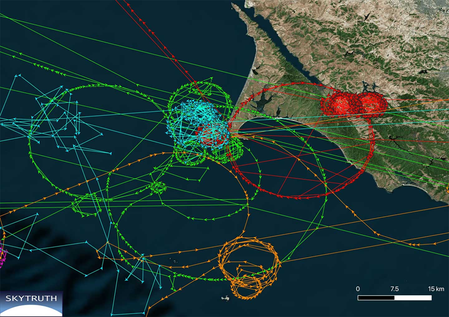
Ships in Russian waters being spoofed to inland airports, vessels in Chinese ports reporting they are inland and circling government buildings, and ships in one part of the world transmitting their location as thousands of miles away and circling in the ocean off northern California are three of the highest provide examples in recent years.
In 2019, the U.S. Coast Guard brought interference with GPS signals as an “urgent issue” to the International Maritime Organization.
In February, President Trump issued an Executive Order on responsible use of positioning, navigation and timing. This workshop is part of the federal government’s efforts, as a part of the order, to educate the public about vulnerabilities associated with over-reliance on GPA.