OEM receiver board includes Septentrio’s innovative SECORX-S service, bringing always-on sub-decimeter accuracy, without the need for additional correction subscriptions
Photo: Septentrio
Septentrio has launched the AsteRx-m3 Sx OEM board, a new dual-antenna receiver that combines Septentrio’s latest core GNSS technology with the SECORX-S sub-decimeter correction service to enable convenient plug-and-play positioning.
High-accuracy positioning is available directly out of the box as GNSS corrections are automatically streamed to the receiver. This significantly simplifies the user’s GNSS receiver set-up process and eliminates completely the hassle of corrections service subscription and maintenance.
Corrections are delivered via internet or via L-band satellites ensuring sub-decimeter service even in remote locations where there is no easy internet access.
“With the AsteRx-m3 Sx, we combine our latest GNSS innovations of the AsteRx-m3 family with the convenience of the SECORX-S always-on corrections, all in the same product,” said Danilo Sabbatini, product manager at Septentrio. “This offers higher reliability and operational efficiency to our customers, at an even lower cost.”
With its dual-antenna configuration, AsteRx-m3 Sx offers heading information immediately from power-up, allowing path optimization and fully informed navigation from mission start. Septentrio’s renowned GNSS+ algorithm suite ensures robust and reliable operation in challenging environments even in the presence of RF interference and under heavy vibrations, the company said.
AsteRx-m3 Sx offers PPP-RTK sub-decimeter accuracy with fast convergence time in the U.S. and Europe.
Movement, closeness, privacy — many things we took for granted a few months ago have become luxuries after the onset of COVID-19. To get an understanding of the scale and impact of the virus, we can look at global movement trends of people and merchandise using GNSS technology.
Marine
Before the coronavirus pandemic, globalization seemed to be increasing endlessly. Now, we face new trade restrictions, protectionist policies, and a global economic downturn that threatens to stunt growth for years to come.
In April, the World Trade Organization (WTO) forecast that global trade would fall by between 13% and 32% in 2020, surpassing the “great trade collapse” of 2009 spurred by the global financial crisis.
However, the situation isn’t completely bleak. According to a recent Tradeshift report, global trade decreased by 14.8% in the second quarter of 2020, putting us on the optimistic end of the WTO estimate. June saw a rise in trade activity, suggesting that we may be recovering from the initial effects of the pandemic.
Cargo vessels, tankers, tugs, and other kinds of commercial ships are equipped with satellite navigation devices that can receive information from GNSS satellites to compute precise location and time. Maritime tracking insights obtained via GNSS/GPS signals are a great method for measuring the impact of the coronavirus on trade.
Photo: shaunl/E+/Getty Images
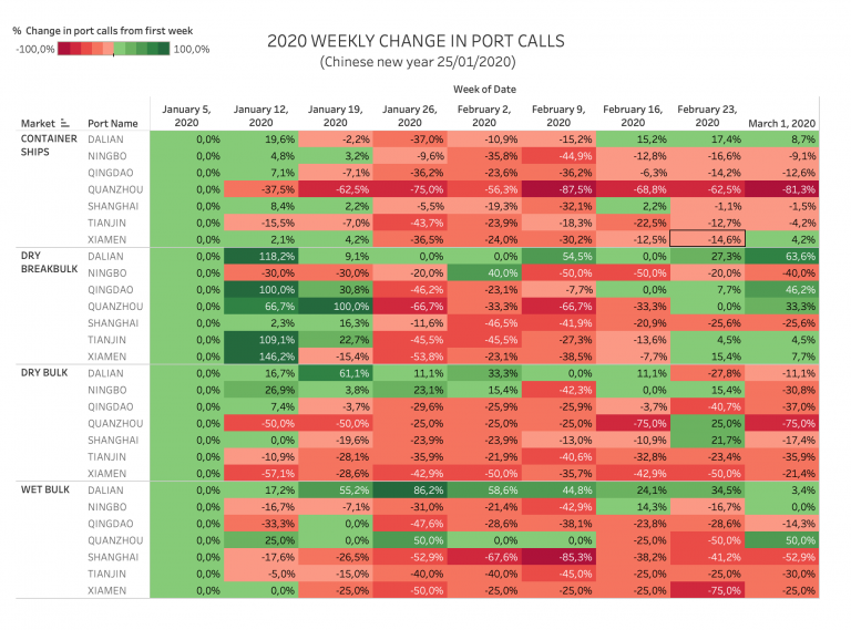
GPS data from MarineTraffic shows that ship arrivals decreased in nearly all of China’s ports from January to March.
Source: MarineTraffic
Just as trade shipping began to pick up in China, the United States and Europe were hit hard by the pandemic. However, shipments have now begun to climb worldwide to compensate for cancellations earlier this year.
The cruise industry, on the other hand, shows little indication of recovery. Cruises were the fastest growing segment of the travel industry over the past five years — until the pandemic hit.
On June 19, the Cruise Line International Association (CLIA) and Centers for Disease Control and Prevention (CDC) announced a “no sail order” for cruise ships. The order has been extended through Sept. 30. Furthermore, the cruise industry’s reputation has been damaged by multiple outbreaks on ships, most recently the MS Roald Amundsen of Norway. At least 43 people were infected on the MS Roald Amundsen, and Norway has now banned cruise ships with more than 100 passengers from disembarking at Norwegian ports.
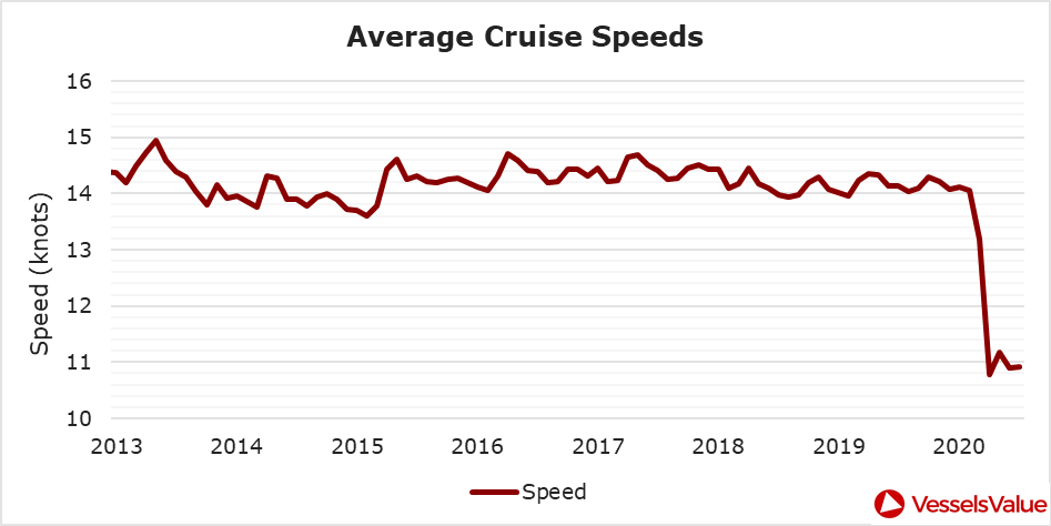
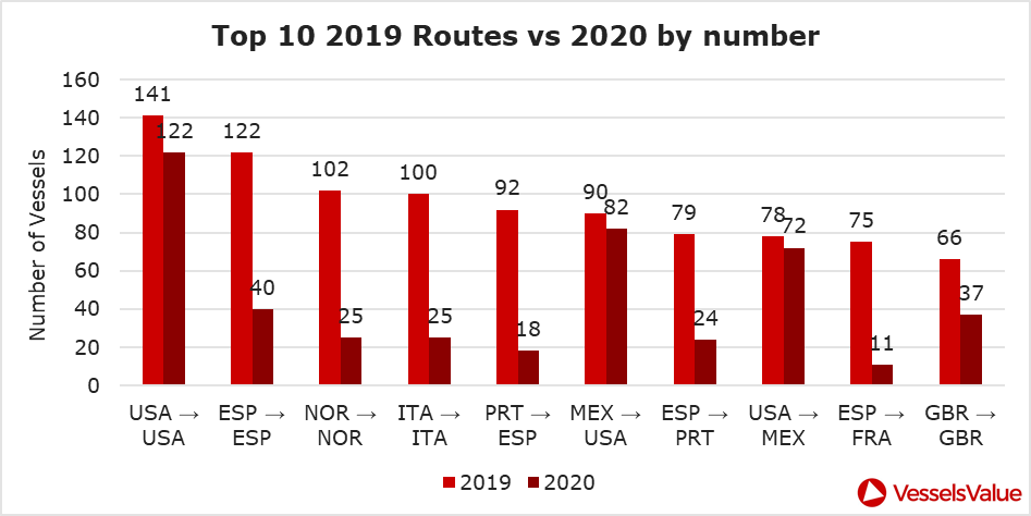
Maritime intelligence company VesselsValue is using AIS data to map cruise ship activity throughout the pandemic. They have noted that while cruise ships typically sail at 13.5 knots to 15 knots, average speed has dropped to 11 knots in 2020 as ships attempt to lower fuel costs. Port-to-port sailings have declined for the 10 most popular cruise routes.
Source: VesselsValueSource: VesselsValue
Most of the port-to-port sailings that constitute the 2020 columns in the above graph actually represent ships being repositioned for a break in service, also called a “layup.” Layups can cost cruise companies millions of dollars per month, but with no sail orders and port closures, they are a necessary expense.
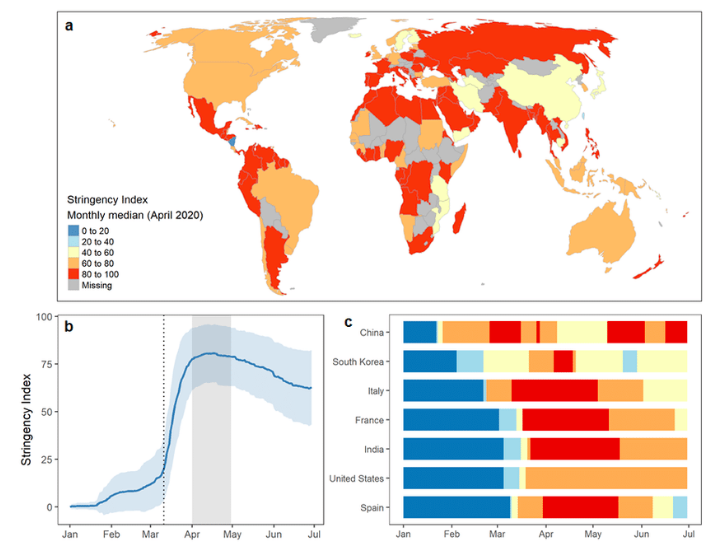
According to the Oxford COVID-19 Government Response Tracker, a real-time monitoring system that evaluates government policies, April marked the strictest lockdown measures across all 133 available coastal countries. The tracker uses a stringency index between 0 and 100 based on national containment and closure policies.
Source: Oxford COVID-19 Government Response Tracker
Air
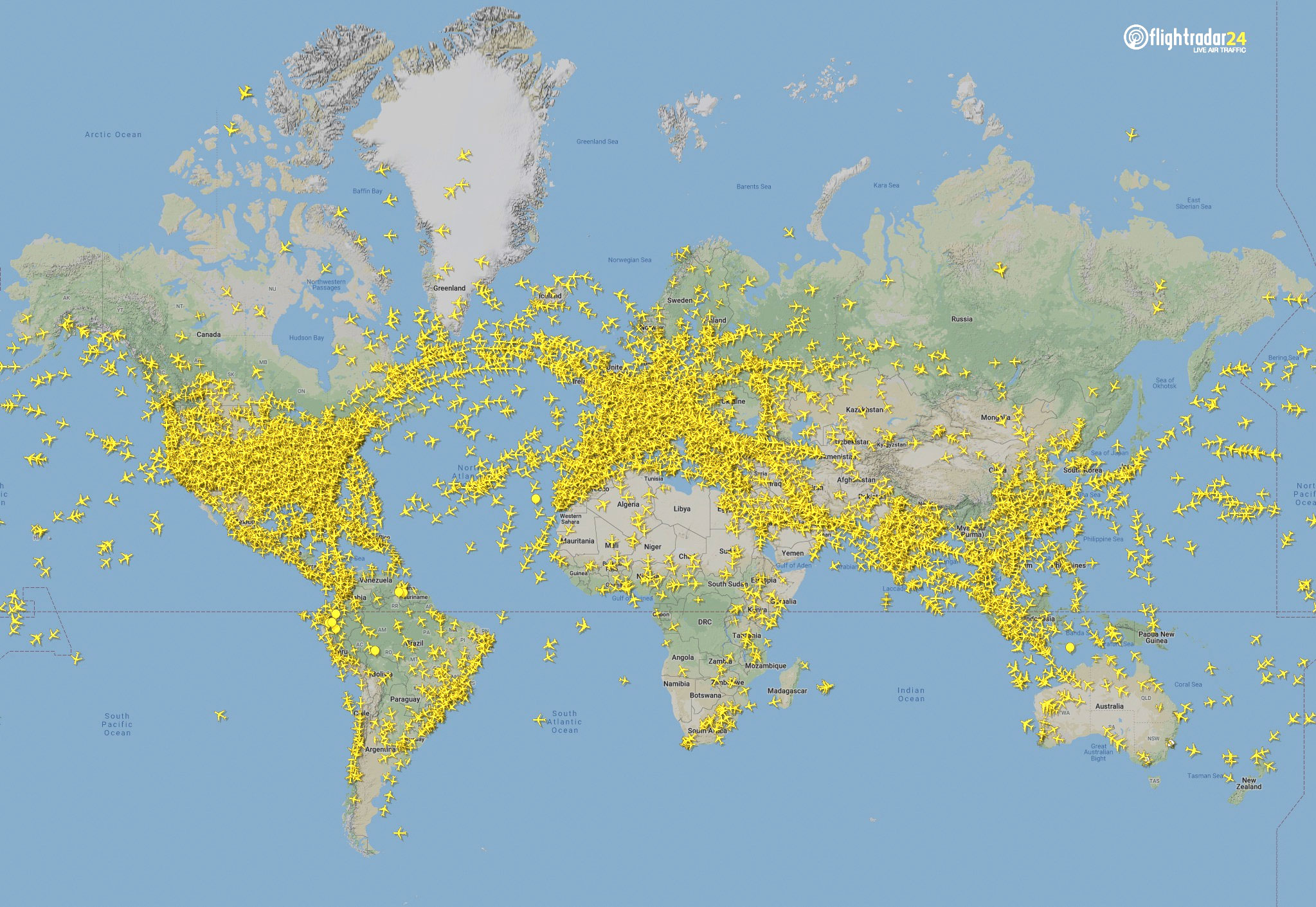
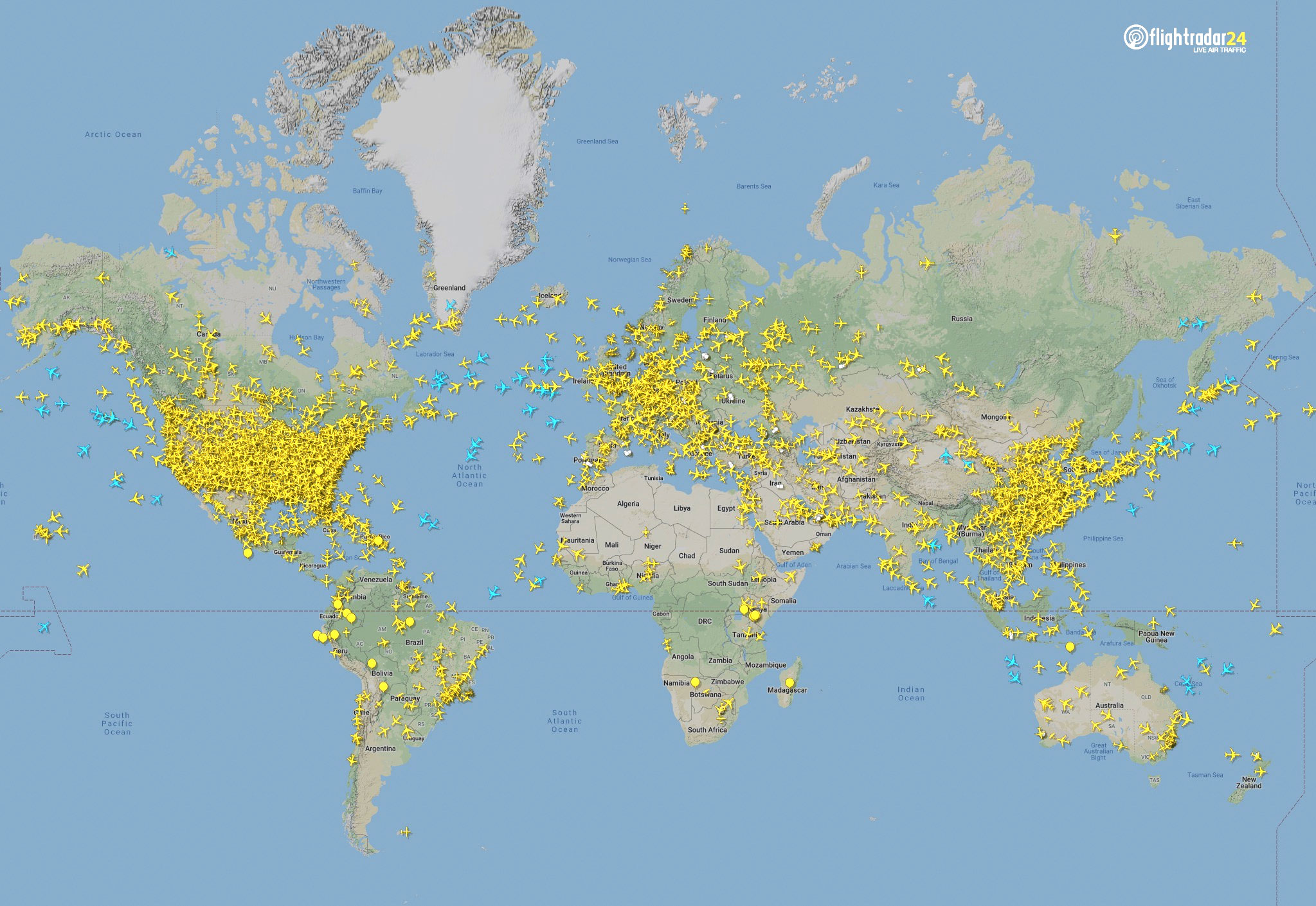
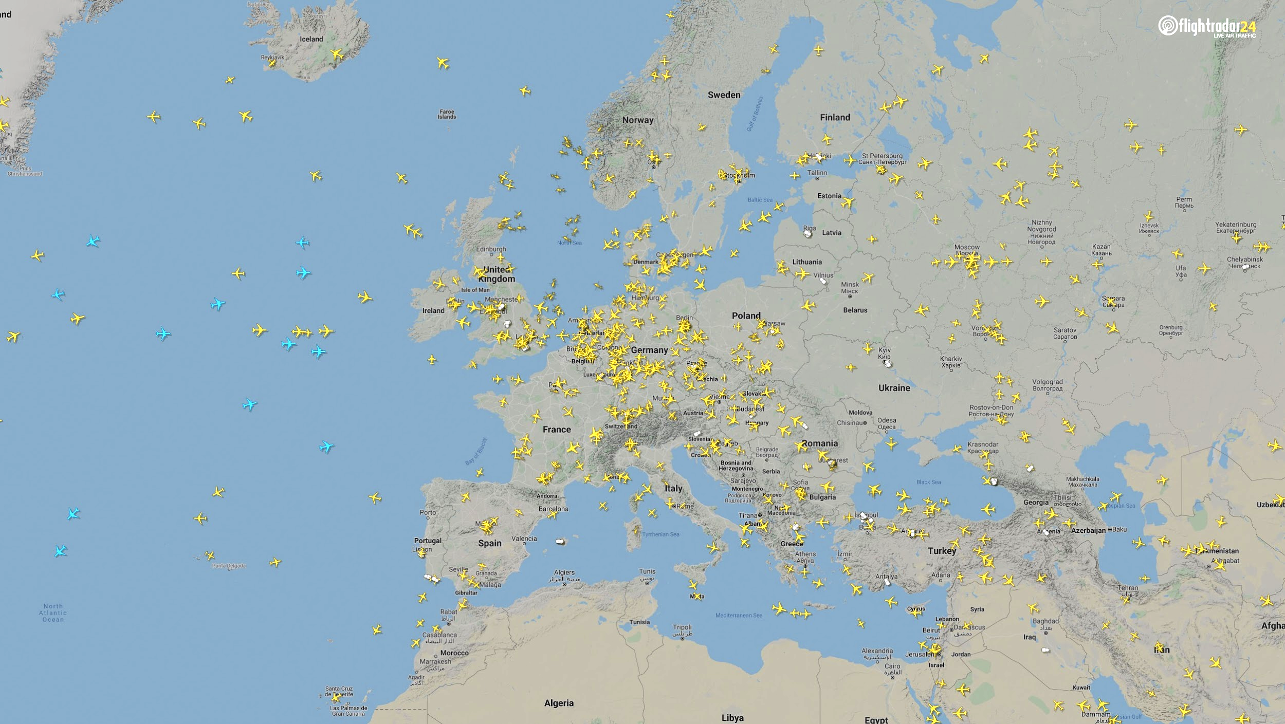
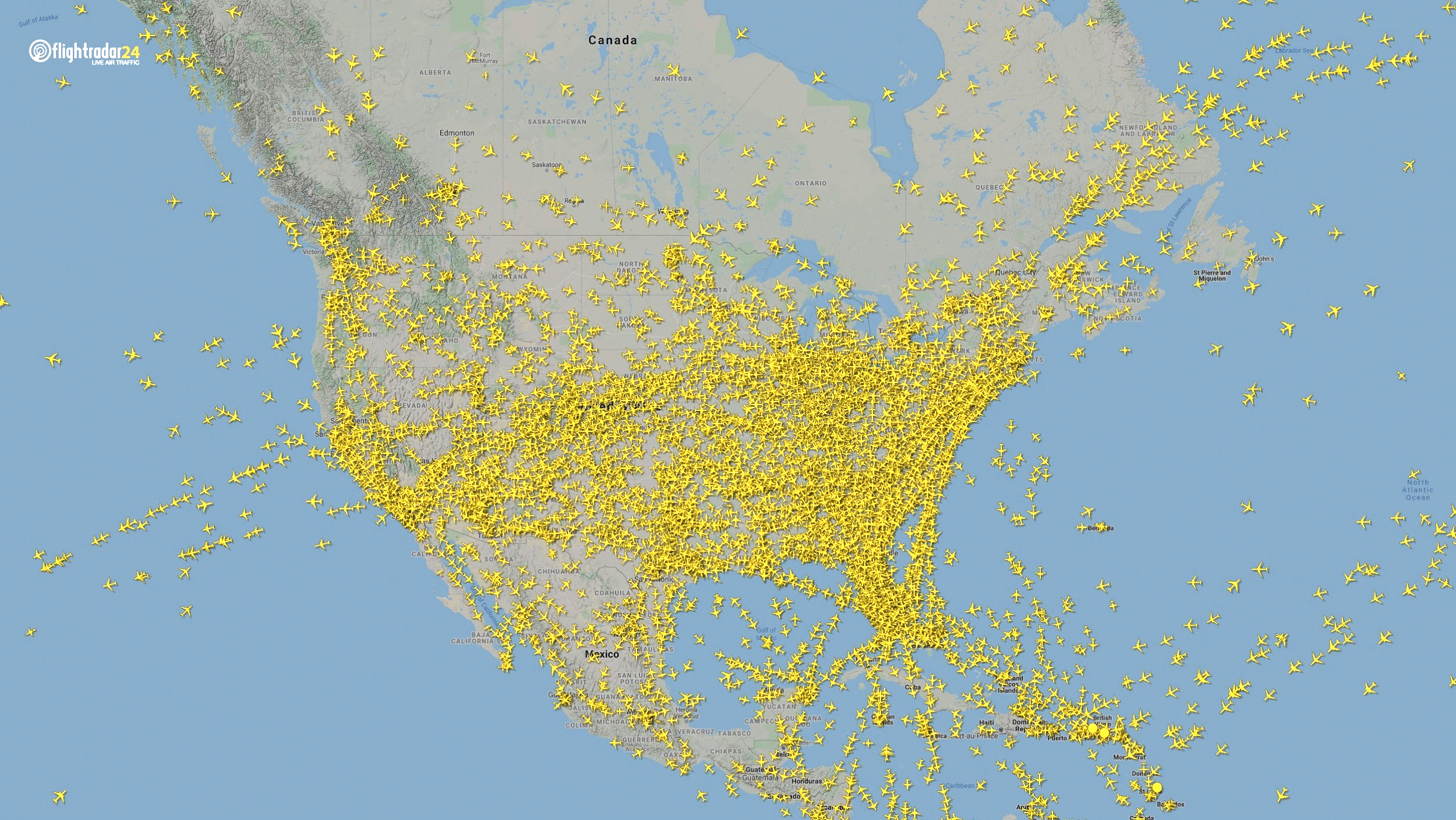
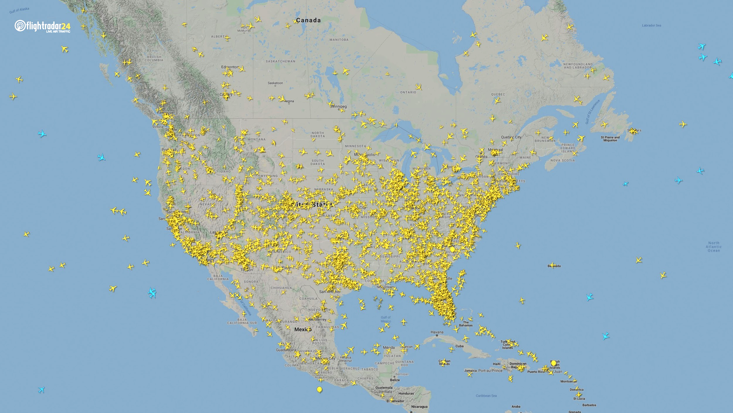
Commercial air traffic has decreased as well. According to GPS flight tracking service Flightradar24, the number of global daily flights was slashed by nearly two thirds between March and April. While there were 15,012 flights in the air at 15:00 UTC on March 7, there were only 5,275 at the same time on April 7.
Global air traffic March 7, 2020. (Source: Flightradar24)Global air traffic April 7, 2020. (Source: Flightradar24)
There were 55% fewer flights in the last week of March 2020 than in the last week of March 2019. While all types of air traffic have been reduced for fears of infection, the coronavirus has especially decimated demand for passenger flights. Passenger airlines across the world have canceled flights and cut capacity for the foreseeable future. Some passenger airlines have even switched to transporting cargo in a desperate attempt to avoid bankruptcy.
Looking at regional tracking data can further illuminate the impact of COVID-19 on air travel. Travel restrictions and border closures were enacted en masse in late March, though some nations adopted more stringent policies than others.
Europe
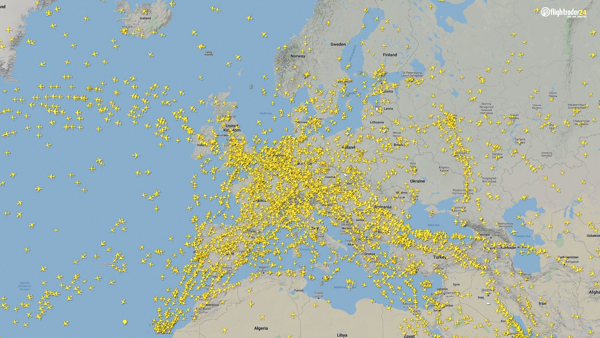
The number of flights in Europe has plummeted since the onset of the coronavirus pandemic. There were 2,400 fewer flights in Europe on April 7 than March 7.
Air traffic over Europe March 7, 2020. (Source: Flightradar24)Air traffic over Europe April 7, 2020. (Source: Flightradar24)
North America
Though air travel has been disrupted across North America, the United States remains significantly more busy than its neighbors. The March 7 image shows 8,400 flights while the April 7 image shows 2,950 flights, most of them concentrated over the United States.
Air traffic over North America March 7, 2020. (Source: Flightradar24)Air traffic over North America April 7, 2020. (Source: Flightradar24)
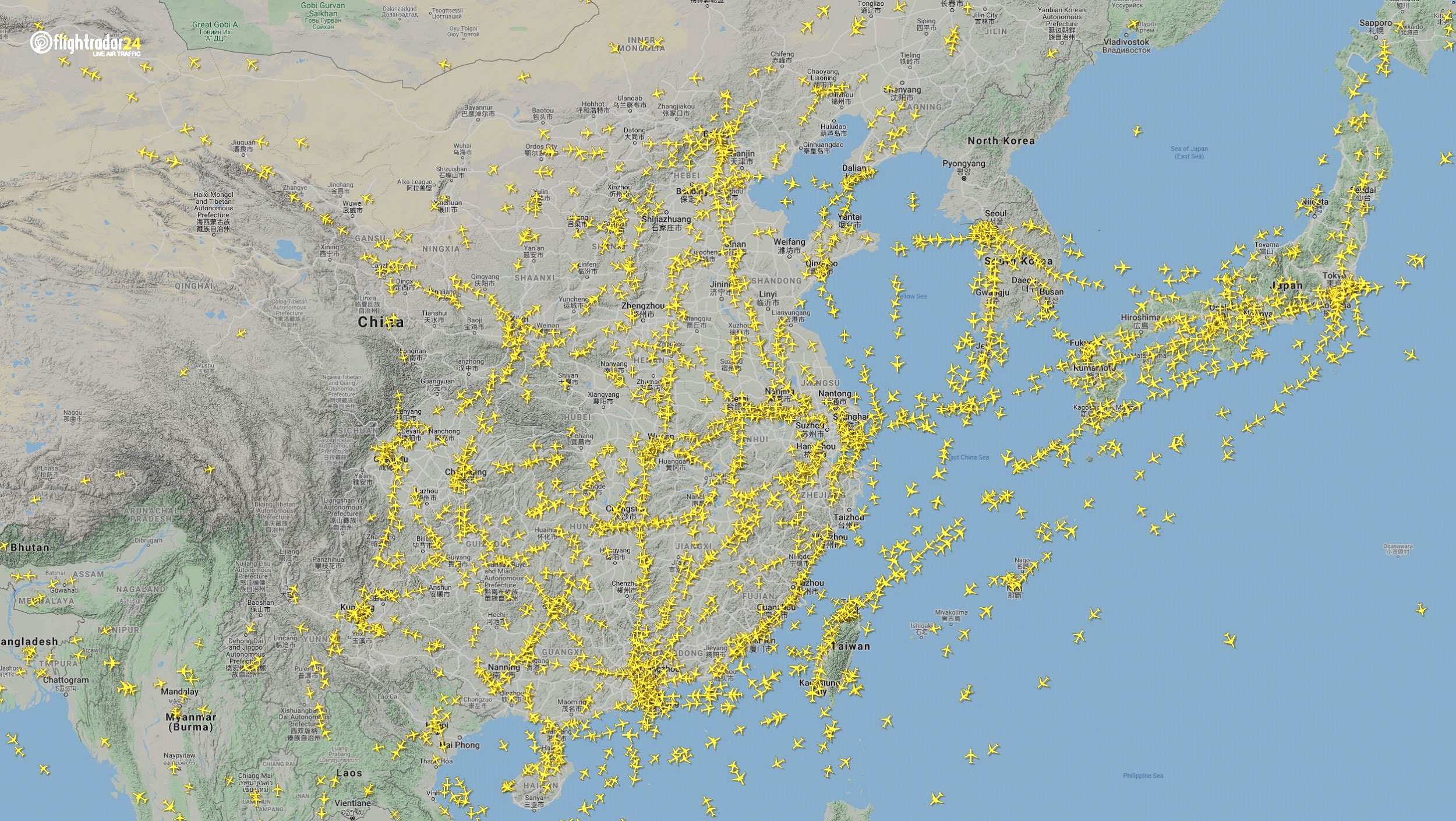
East Asia
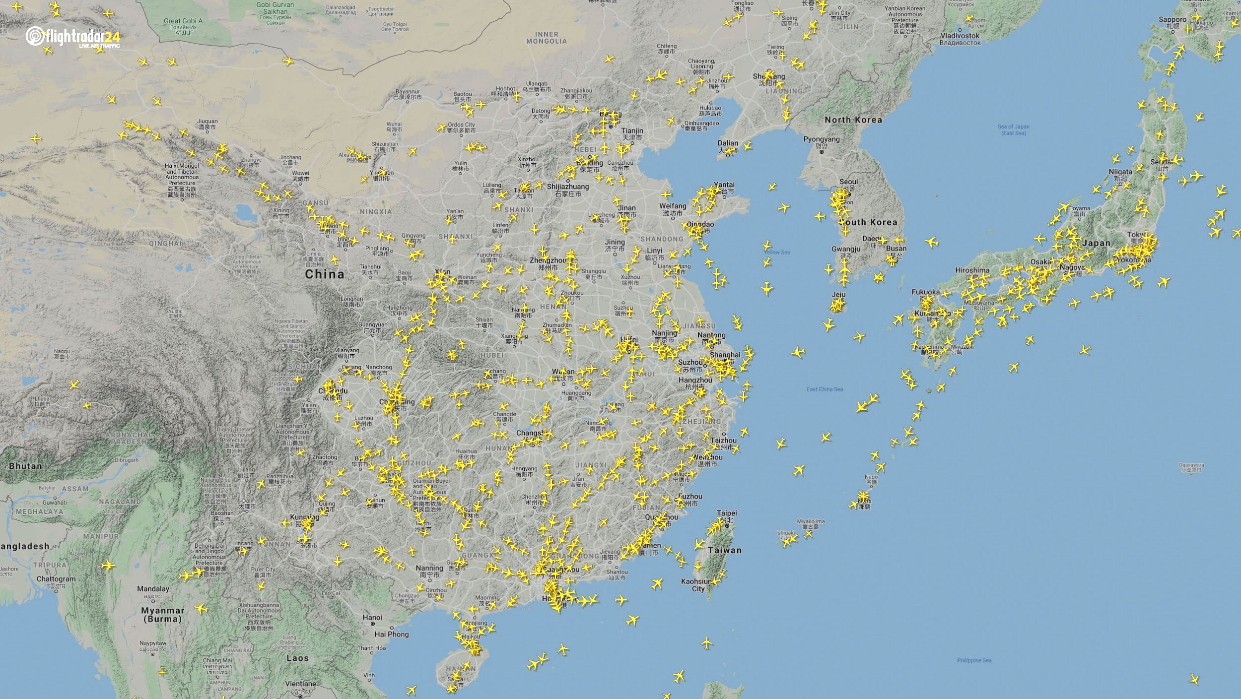
The decrease in air traffic over East Asia has been severe and persistent. Since China and its neighbors began to experience a trade downturn as early as the third week of January, we can compare January 7 to April 7 to capture the effects of the coronavirus. As of late July, air traffic at China’s busiest airports was still down approximately 60% from normal levels.
Air traffic over East Asia January 7. (Source: Flightradar24)Air traffic over East Asia April 7. (Source: Flightradar24)
Ground
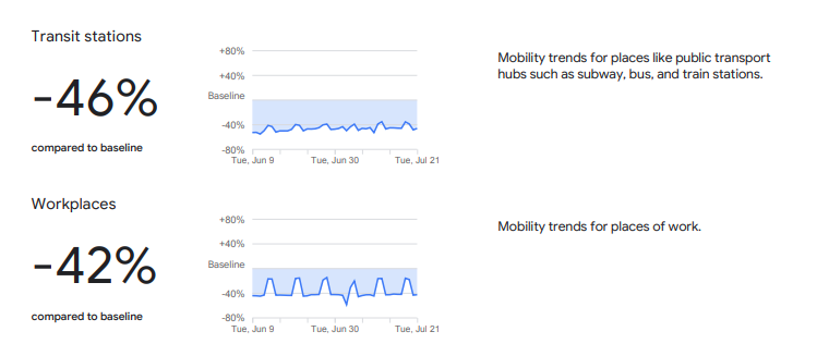
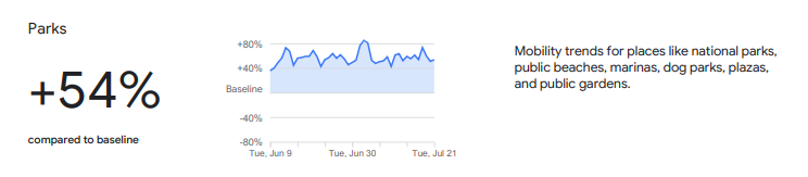
Google has released — and continues to update — a series of community mobility reports that chart movement trends in public spaces. The reports are a compilation of GPS data for Google users across the world.
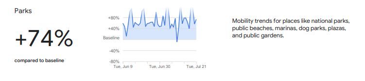
Mobility changes are particularly stark for regions hit hard by the coronavirus. New York state showed a 46% reduction in visits to transit stations and a 42% reduction in visits to workplaces in June and July compared to pre-pandemic baseline levels. New Yorkers are also visiting parks 74% more often.
Screenshot: GoogleScreenshot: Google
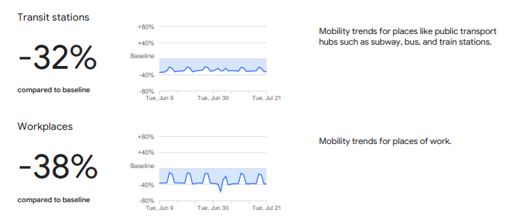
Trends in the United States as a whole are also dramatic.
Screenshot: GoogleScreenshot: Google
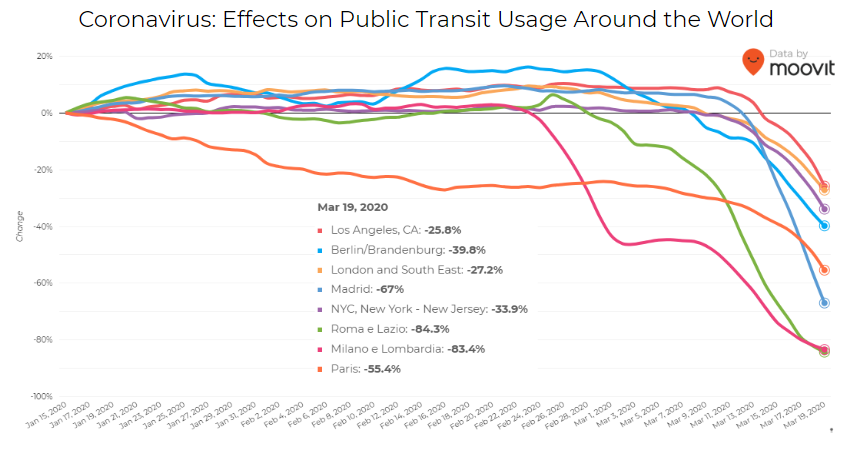
Israeli journey-planning app Moovit is using mobile phone data to document trends in public transit ridership. Many of the world’s largest metropolitan cities experienced a steep decline in ridership between mid-January and late March. Millions of people that rely on mass transit have had to cope with cumbersome rules and the danger of catching the virus itself. Efforts to reduce overcrowding on trains and buses have translated into reduced capacity requirements and therefore, lengthy wait times. The rise of remote work has also lowered public transit ridership.
Screenshot: Moovit
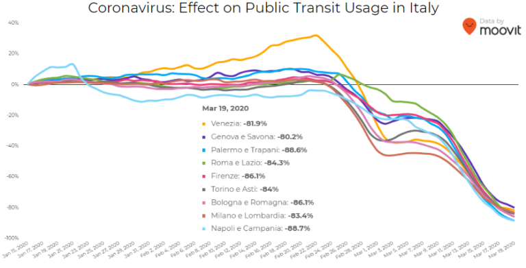
Italy was hit particularly hard – and early – by the pandemic. Two large outbreaks occurred in Northern Italy in late February, prompting widespread closures and government-mandated quarantines in Lombardy and 14 neighboring provinces. Public transit ridership plummeted when the quarantine took effect in early March.
Screenshot: Moovit
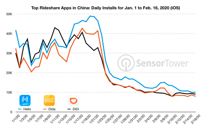
Usage of GPS-reliant ride-hailing apps has also dropped severely. Daily installs of China’s three biggest ride-hailing apps were down 75% the week of February 10 compared to the same week in 2019.
Source: Sensor Tower
American ride-hailing giants Uber and Lyft have seen similar losses. However, business for food delivery apps like Uber Eats and Grubhub are on the rise as more people stay home instead of grocery shopping.
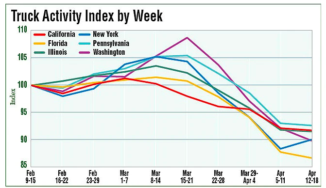
The impacts of COVID-19 have been less severe — but still significant — for the trucking industry. The U.S. trucking industry is an economic powerhouse, typically generating over 700 billion in annual revenue and transporting 72.5% of American freight. The American Transportation Research Institute generated a truck activity index based on GPS data across six states from the week of February 9 to the week of February 12. The data shows an initial spike in trucking operations due to increased demand for consumer goods and medical supplies. However, as stay-at-home orders and restrictions ceased business operations across the country, truck activity declined.
Source: American Transportation Research Institute
Coronavirus safety restrictions adopted by countries across the world have generally begun to loosen up, for better or for worse. It will be interesting to see how the coming months unfold through the lens of GNSS data.
Roi Mitt works for Regulus Cyber, a company researching GPS cybersecurity and offering various software products to protect the integrity, reliability and security of GNSS devices. The company’s products are designed for multiple industries using GPS-based time and location, in order to ensure a future in which GNSS technology is safe and reliable to use.
At ION GNSS+ 2019, Spirent Federal Systems’ Jeff Martin and Spirent Communications’ Adam Price discuss the company’s latest product: the GSS9000 GNSS simulator series. According to the company, the simulator boasts up to 320 channels and 10 independent RF outputs.
Emcore achieved success in an ultra-high-altitude flight simulation conducted by CAST Navigation, which tested Emcore’s SDN500 inertial navigation system (INS).
Emcore is a provider of advanced mixed-signal products that serve the aerospace & defense and broadband communications markets.CAST Navigation builds simulators for testing and validating GNSS/INS performance in high-end navigation systems.
CAST used Emcore’s SDN500 inertial navigation system (INS) for the test, which required simulating performance at an altitude more than 24,000 meters and velocities over 600 m/s. Only a few aircraft in the world have such capabilities, including the SR-71 Blackbird, but it is not practical to participate in a test flight on the SR-71. Simulating the SDN500 INS test flight to specific customer profiles on a CAST system is straightforward and cost-effective.
Testing began with a stationary period on the ground while the SDN500 initialized and transitioned into air-navigation mode. Then the flight trajectory entered a series of maneuvers, speed and altitude changes that provided observability for various parameters with corresponding changes in the calculated figures.
Emcore relies on GNSS/INS simulators for hardware-in-the-loop testing to verify the expected performance of algorithms. Emcore CORE sought to validate the velocity and altitude limits of a new GNSS receiver along with the algorithm performance in a tactical-grade SDN500 system. In the final analysis, the GNSS receiver and navigation algorithm was confirmed to operate as expected throughout the operation for all three of the customer’s dynamic constraint scenarios.
“We were extremely pleased to demonstrate how Emcore takes advantage of the functionality contained in the CAST simulator to prove-out our robust product performance in customer environments,” said David Hoyh, director of sales and marketing for navigation products, Emcore..
“During the times when there was no valid solution from the GNSS receiver, the algorithm maintained an accurate solution using only the data from the IMU,” explained Andy Williams, senior field application engineer at Emcore who spearheaded the effort. “In addition, there was no algorithm instability or discontinuity when the GNSS receiver resumed, providing a solution to the algorithm. Throughout this entire profile, even when GNSS signal is lost, the SDN500 maintains an accurate navigation solution. This test is not possible without the synchronized GNSS radio frequency and trajectory matching IMU data provided by the CAST system.”
Source: “A True Reference. Theory Meets Reality in Synchronized Simulation Environments,” Inside GNSS, Volume 15/Number 5, September/October 2020, Pages 28, 29, 30.
The Galileo Second Generation will phase in of new services, improve existing services and increase security
The technology multinational GMV is playing a key role in the Galileo Second Generation (G2G) ground segment.
G2G’s main objectives are to phase in new services, improve existing services, and boost system robustness and security while cutting both operating and maintenance costs, to cement Galileo’s position as one the future’s top GNSS.
Three phases. G2G is divided into several phases. In the first, led by the European Space Agency (ESA), mission requirements were defined at system level. This was followed by a preparation phase, then an implementation phase.
As well as priming several mission-requirement projects, GMV, since 2018, has been heading one of the consortia working on G2G’s complete ground segment during the preparation phase.
Within the preparation phase — shortly before the start of the COVID lockdown — ESA announced the successful end of the first phase before launching a bid invitation for the second phase as the prelude to G2G implementation.
Although publication of the bid invitation for this phase was eventually pushed back until mid-June, GMV never broke off its G2G activities. In recent months GMV has brought new recruitments and partners into the project team while also working on new ideas and kicking off some project activities.
Team members have attended various skills-training courses, some of them gaining certification under SAFe 5 Agilist. During these months, GMV has also been working under new pandemic circumstances with teleworking, virtual meetings and new toolboxes.
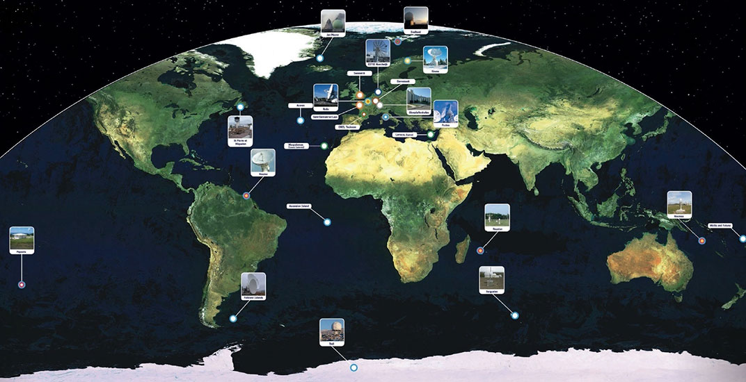
First Generation. Galileo First Generation (G1G), running since December 2016, consists of space infrastructure (26 satellites to date) and ground infrastructure. Galileo is now providing 20-cm-precision positioning, navigation and timing services for over 400 million users around the world.
The worldwide Galileo ground segment includes two control centers (Italy and Germany) as well as various tracking, uplink and sensor stations and monitoring and test centers. (Image: ESA)
The UPP results will provide a proof of concept for UTM capabilities and serve as the basis for policy considerations, standards development and the implementation of a UTM system.
“The demonstrations will help move us closer to safe beyond-visual-line-of-sight drone operations,” said Pamela Whitley, the FAA’s acting assistant administrator for NextGen. “Flight testing UTM capabilities in high-density airspace will help us develop policy for safely and efficiently integrating drones into our national airspace while benefiting and serving communities.”
The demonstrations showcased emerging UTM capabilities that will support beyond-visual-line-of-sight (BVLOS) operations:
The FAA UTM Flight Information Management System prototype and infrastructure, which gives the FAA access to information from industry and other stakeholders.
New technologies and data to validate the latest international standards for remote identification and support authorized users with specific operator data.
In-flight separation from other drones or manned aircraft in high-density airspace to validate recently proposed international UTM standards to help drones avoid each other.
UAS volume reservations to notify drone operators of emergencies and make sure other UTM capabilities work properly in these scenarios.
Secure information exchanges between the FAA, industry and authorized users to ensure data integrity.
Each event attracted more than 100 participants and included local and state elected officials and representatives from international civil aviation authorities. Both test sites collaborated with drone operators and local public safety agencies to demonstrate scenarios that featured various complex UTM capabilities working together to support BVLOS operations with increasing volumes and densities.
MAAP hosted an event on Oct. 28 in partnership with UAS Service Suppliers (USS) AirMap, AiRXOS, ANRA Technologies, and Wing. On Nov. 9, NYUASTS hosted its showcase in coordination with the Griffiss International Airport, Northeast UAS Airspace Integration Research Alliance (NUAIR), and USS partners AiRXOS, ANRA Technologies, AX Enterprize, and OneSky.
The FAA has worked closely with NASA, industry and other stakeholders since 2017 to identify the initial set of capabilities needed to support small drone operations and advance UTM. The FAA Reauthorization Act of 2018 extended the objectives of the program to further enable safe BVLOS drone operations, paving the way for the program.
Stay tuned for more updates on how emerging technologies are being field tested to support the growing UAS industry.
The Bluesky MetroVista range includes high-resolution imagery combined with high-accuracy, wide-scale 3D models. (Image: Bluesky)
Aerial mapping company Bluesky is releasing its entire catalog of geographically referenced oblique aerial images of cities in the United Kingdom (UK) via a new subscription-based streaming service.
Working with Geoxphere, a specialist in cloud-based GIS, Bluesky will offer MetroVista imagery via an easy-to-use web viewer that also includes measurement tools for detailed analysis of building features, façade details and street furniture locations.
“Oblique imagery offers an unparalleled view of the built environment revealing real world features simply not present in any other type of aerial image or map,” commented Rachel Tidmarsh, managing director of Leicestershire-based Bluesky International. “The MetroVista imagery can be used to inform decision making with time stamped intelligence, and even evidence, as well as improving engagement with colleagues through better communication of ideas. All of this without even leaving your desk!
“However this wealth of information, as you would expect, can present some issues when it comes to storing and consuming data. The MetroVista Oblique Viewer overcomes these issues meaning the value of the data can be realised without the burden of storing, processing or updating.”
With a data-as-a-service (DaaS) solution powered by Geoxphere’s XMAP geospatial cloud technology, the MetroVista Oblique Viewer is a fully managed subscription service meaning there is no need to download or store large volumes of data locally. The MetroVista Oblique Viewer does not require any specialist software, plugins or downloads and, as the data is also managed, newly captured images are automatically added to an account as they become available.
The MetroVista Oblique Viewer has split screen options and rotating views allowing the user to toggle through images to get a 360 degree view of a building. The Bluesky Geoxphere Viewer also includes height and area measurement tools for recording a building height or distance from a feature and its façade area.
Captured using the world’s first large format imagery and lidar hybrid airborne sensor, Bluesky MetroVista imagery collection includes simultaneously captured oblique and vertical aerial photography. The MetroVista datasets also include geographically accurate, photo-textured, mesh models ready for use in 3D GIS, CAD and other modelling software as well as visualisation, gaming and Virtual Reality workflows.
Bluesky has already captured MetroVista data for cities such as London, Birmingham, Manchester, Bristol, Nottingham, Oxford, Cambridge, Brighton, Norwich, Leicester, Derby and Newcastle as well as Bournemouth, Brighton, Cardiff, Doncaster, Eastbourne and Southend.
A shipping container with several pieces of key GNSS and survey instrumentation is bound for the East African country of Rwanda. The equipment, an in-kind donation from Topcon Positioning Group, will be used in support of Bridges to Prosperity (B2P), an organization committed to building trail bridges to improve the lives of people in rural areas worldwide.
Photo: Bridges to Prosperity
According to B2P, almost a billion people around the world lack safe access to critical resources like healthcare, education, or employment due to an impassable river. Building safe, structurally sound trail bridges for people to travel by foot, bicycle, or motorcycle has an immediate, impactful effect on the lives of those in the area.
“We are fortunate that, even with challenges presented by the COVID-19 pandemic, we have been able to implement new safety measures with limited disruption to our building schedule,” said Devin Connell, B2P’s corporate program director. “Right now, our surveying efforts predominantly involve simple equipment such as auto levels and range finders, which can be time consuming when complex survey information is needed. The equipment from Topcon will increase our surveying capabilities, streamline the design process, and support us in building more trail bridges for isolated communities.”
Photo: Bridges to Prosperity
In addition to the instruments — a pair of GNSS receivers, two total stations and data collectors — B2P will have access to the Topcon suite of software products, which will assist both the design process and the transfer of files from the field to their remote office or the engineering team working with them. According to Ron Oberlander, vice president of Topcon Global Professional Services group, however, the company’s role extends well past the equipment itself.
“We are excited to be a contributing part of this program,” he said. “But, in order for B2P to use these solutions to their fullest and increase their overall productivity, a training effort will be needed and we’re already setting plans in place for that to happen.
“In addition to conducting online virtual training sessions with B2P staff, we are making eLearning possible by allowing access to MyTopcon, our company knowledge portal. With these tools, they can gain familiarity with their receiver or total station or use the Topcon software to learn how to collect points — all without having us there. They want to be able to hit the ground running once the equipment arrives and this will help make that happen.”
Connell said that their improved survey capability will help accelerate the company’s bridge building. “We go out and survey a year in advance, looking at as many as 100 different remote sites and, tough as it might be, establish priorities with the local governments. We are looking forward to our continued growth in 2021 and, thanks to the generosity of companies like Topcon, that process will be a much better one.”
“Fourth industrial revolution and advanced technology” for all sectors
The government of South Korea signed an agreement on Oct. 28 for its new eLoran system to support digital radio and television broadcasts. The Memorandum of Understanding (MOU) also provides for the government to use commercial radio and television infrastructure to transmit GNSS integrity and correction information.
Titled “Utilization of Next Generation Maritime PNT Information,” the MOU is between the Ministry of Oceans and Fisheries and the public broadcaster Munhwa Broadcasting Corporation (MBC).
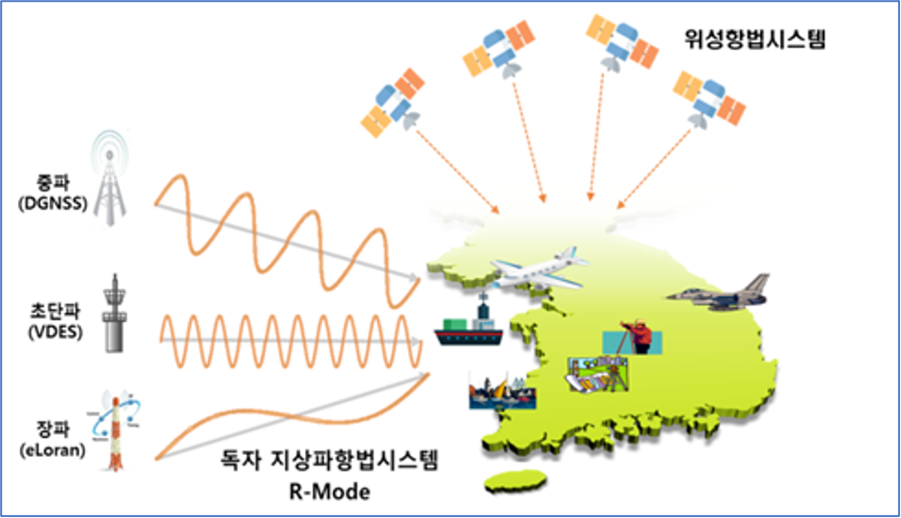
Image: Ministry of Oceans and Fisheries, South Korea
Timing signals from GPS/GNSS are often used to enable digital broadcasts. These signals have been regularly blocked by jamming from North Korea in the past. MBC officials report that using eLoran timing signals will allow the company to continue operations when signals from space are not available or reliable for whatever reason.
Also in the agreement is the government’s use of MBC’s network to transmit GNSS integrity and correction information as part of a project to enable 10 cm location accuracy.
Both of these efforts appear to be part of a “maritime PNT system of systems” approach being pursued by South Korea to ensure maritime navigation, with spill-over benefits to other sectors. Core technologies will be eLoran, VEDS-R mode, and differential GNSS. This is very similar to the “hybrid system” called for by the European Space Agency-sponsored MarRINav project in the United Kingdom.
While the MOU and efforts discussed are nominally maritime focused, the South Korean government’s intent is to benefit and support all sectors. According to the press release about the MOU signing, the ministry will promote the system “so that eLoran, the core technology of the era of the fourth industrial revolution, and next-generation advanced marine PNT technology can be actively used in a wider variety of fields.”
eLoran services will be available in South Korea next year. Two existing Loran-C transmitter sites will have been upgraded to the eLoran standard, and one new eLoran transmitter site added. Two differential eLoran correction stations have already been deployed as part of the eLoran testbed.
South Korea has been studying upgrade of its Loran-C network to the more automated and accurate eLoran standard since 2016. The government describes eLoran as an “advanced terrestrial navigation system that can stably provide PNT services without radio disturbance by using a terrestrial transmission tower rather than a satellite.”
UrsaNav of Billerica, Massachusetts, was awarded a contract in July to supply and install a testbed eLoran system near Inchon, South Korea. Initial tests were completed in September, according to the government press release. “We conducted a performance demonstration experiment that actually compared the performance of the GPS receiver and the GPS-eLoran integrated receiver by transmitting jamming and spoofing signals to the ship. It was confirmed that the GPS-eLoran integrated receiver displayed the correct location while the GPS receiver did not.” Additional testing should finish within the next few months.
Current users of Loran-C signals in Korea will be unaffected by the transition from Loran-C to eLoran. Upgraded receivers will be required, though, if users want to take advantage of eLoran’s improved accuracy and other features.
Development of the system to transmit GNSS integrity and correction information to enable 10-cm accuracy is not as far along. The government has said it expects services to be available in 2023.
At the signing ceremony, Minister of Oceans and Fisheries Moon Sung-Hyuk said “eLoran in the era of the fourth industrial revolution, and next generation advanced maritime PNT technology are the nation’s core infrastructure resources that can be used throughout the industry. It is expected that the public will be able to use PNT services more stably by actively sharing the infrastructure and technology we have.”
“Seen & Heard” is a monthly feature of GPS World magazine, traveling the world to capture interesting and unusual news stories involving the GNSS/PNT industry.
Photo: welcomia/ iStock / Getty Images Plus / Getty Images
COVID brings better measurements
A new study shows that the quality of GNSS reflectometry measurements may have improved significantly during the pandemic because of the lack of cars parked near the ground station. The study, carried out by geodesists from the University of Bonn, investigated the location of a precise GNSS antenna in Boston, Massachusetts, where parked cars near the ground station decreased accuracy from 2 to 4 centimeters. GNSS reflectometry is used for earthquake early warning systems, determining flood risks, and many other geodesy applications. Read more about the study.
Photo: Daniel Leeb/Iceland Space Agency
But can you press the right button?
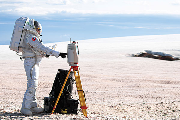
A Riegl long-range terrestrial laser scanner helped field test the newly designed MS1 Mars Analog Spacesuit. The test simulated how the new spacesuit design would perform in a polar, Mars-like environment ‚ in this case atop the Grimsvötn Volcano on the Vatnajokull Glacier in Iceland. The field test was part of a research expedition conducted by the Iceland Space Agency. The team included NASA Coordinator and Rhode Island School of Design (RISD) Professor Michael Lye, who led the team that designed the MS1, and doctoral students from the University of Iceland.
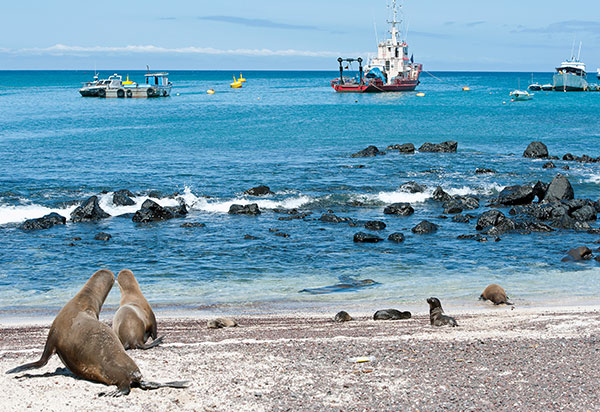
In June, a fleet of 300 Chinese fishing vessels entered the waters of the Galápagos Islands, reports environmental news website Mongabay. The ships had ostensibly turned off their GNSS-based automatic identification system (AIS) transponders to engage in illegal activities. Their presence was detected by their overhead lights and industrial jigging machines to attract and catch squid. An analysis of radio-signal data also detected unidentified ships within Ecuador’s Galápagos exclusive economic zone (EEZ).vThe new data provide additional, but still inconclusive, evidence that the Chinese fleet may have entered Ecuador’s EEZ.
A pilot program in Shenzhen will use China’s BeiDou to regulate bike-sharing and address the problem of bikes parked chaotically or in unpermitted areas, according to Chinese news service Caixin. The program is part of Beijing’s push for wider adoption and commercialization of BeiDou. With guidance from the city’s transportation bureau, BeiDou modules on shared bikes will display parking spots. Users will have to park them within geofenced parking spots.
In June, Alstom became the first railway manufacturer to integrate certified data-fusion algorithms for fail-safe train localization, using position and speed of trains based on GNSS data coming from multiple constellations, including Galileo.
The added value of Galileo and EGNOS in the European railway sector is widely known, especially when it comes to non-safety applications, such asset management and passenger information services.
In recent years, however, with multi-constellation becoming the norm and multifrequency receivers being adopted rapidly, rail stakeholders view GNSS-based solutions as game-changers for the future of European Train Control System (ETCS).
A recent example of EGNSS adoption in rail operations is the innovative odometry solution deployed by Alstom to measure the location and speed of its trains. The French rolling-stock manufacturer introduced a new sensor type, with a hybridisation of satellite information and inertial sensors. The solution is primarily using GNSS Doppler information, derived from Galileo, GPS and GLONASS constellations (configurable).
Such use allows to improve the overall confidence in the resulting speed, along with specific algorithms to master the resulting location accuracy. The GNSS receiver is an automotive grade receiver manufactured by u-blox. The inertial measurement unit (IMU) used to supplement information in case of GNSS loss is based on enhanced micro-electromechanical systems (MEMS) technology, with temperature compensation.
The new odometry system based on data fusion, which Alstom is currently implementing in Norway, is applicable to all types of trains and all environments, including the harshest weather conditions. It is estimated that by 2026, 450 trains will be equipped with this new feature across Norway.
Increased safety, lower costs for rail companies
Wheel slipping and sliding especially during demanding weather conditions can affect the odometer accuracy and the proper functioning of the different sensors involved. By incorporating Galileo signals as an extra layer of accuracy, Alstom managed to create a system that is capable of providing a more robust speed and location estimate. This space data fusion approach —certified by Belgorail — minimizes the need for the costly external radar components for localisation and speed measurement currently used.
“Industry embedding Galileo in their solutions is the proof that we are on the right path to ensure the market uptake of the EU Space Programme technology,” said Rodrigo da Costa, GSA executive director. “This is a recognition of the capability of EGNSS to reduce the need for infrastructure and related cost, while maintaining the operational safety of ETCS.”
BroadGNSS will procure innovative solutions for applications, synchronization and monitoring of critical mobile broadband communication infrastructure and information assets for public protection and disaster recovery (PPDR) Operations.
The project brings together three members of a joint procurement team:
French Ministry of Interior (lead procurer)
Estonian Infocommunication Foundation
Finnish Erillisverkot
The team will be supported by PSCE and Austrian GNSS company OHB Digital.
The agreement provides for a total budget of €3.6 million over 40 months, beginning this Dec. 1. Of that, €2.5 million is reserved for pre-commercial procurement of innovation solutions. This budget will be made available to industry following an open and competitive process.
BroadGNSS will seek innovative solutions to apply European GNSS to further improve the overall capability of trustworthy information exchange, enabled by new broadband mobile communication.
BroadGNSS will consult key government stakeholders across Europe to scope the specific objectives of the PCP procurement. A “prior information notice” will be released to initiate consultation with innovative industry to contribute their knowledge and capabilities to help our team to prepare a formal request for tender to be released later next year.
BroadGNSS will build upon the success of the BroadWay PCP, which is currently in the prototyping phase. Three innovative prototypes are now in development to address the challenge to enable a pan-European mobile broadband system for PPDR. Prototypes will be evaluated in April 2021, with interim demonstrations to the BroadWay group of procurers this month (November). These prototypes are developed under the leadership of key industry heavyweights, Airbus, Frequentis and Leonardo.
The combination of the results of BroadWay and BroadGNSS will contribute to provide improved mission critical services to public safety responders.