Blog

  • TRACE drone carries EGNOS beacon for identification

    TRACE drone carries EGNOS beacon for identification

    Photo: lakshmiprasad S/iStock / Getty Images Plus/Getty Images
    Photo: lakshmiprasad S/iStock / Getty Images Plus/Getty Images

    The first drone of Europe’s U-space TRACE project took its maiden flight Sept. 23. It carried an EGNOS-enabled beacon that allows the identification of the aircraft while guaranteeing accurate, robust positioning.

    The drone lifted off at the ATLAS experimental flight center in Jaén, Spain, an aerodrome equipped for flight tests with unmanned aircraft systems.

    The Regional Minister for Economic Transformation, Industry, Knowledge and Universities, Rogelio Velasco said, “This event shows Andalusia’s commitment to hosting initiatives that promote innovation in the region.”
    TRACE project logoUsing enhanced EGNOS signals, the EU’s regional satellite-based augmentation system, TRACE supports the safe and effective integration of drones into U-space by providing essential services such as e-registration, e-identification and pre-tactical geofencing.

    The smart beacon allows for remote identification of drones flying at a very low altitude, enabling safer integration of drones into airspace through the use of U-Space. This makes it easier for traditional aviation pilots to know the position of drones. The smart beacon also enables better traffic separation when integrated with U-space services, thanks to EGNOS.

    “TRACE is a pioneering project in Europe that will allow us to demonstrate the advantages of EGNOS, particularly in terms of greater precision in locating drones,” said Luis Gómez, CEO of Alter Technology.

    The TRACE project is funded by a GSA EGNOS Adoption in Aviation grant. It designed and developed a smart beacon that leverages the robust signal corrections of EGNOS to improve positioning accuracy, and thus the safety of drone operations at very low altitudes.

    Carolina Jiménez, TRACE project manager at Alter Technology added, “TRACE will demonstrate compliance with the European Drone Regulation, an important aspect within the Alter business line, since one of the fundamental requirements in this new regulatory framework is that each system has the capacity for remote identification for future secure integration within the air space for these systems (U-Space).


    The TRACE project is led by Alter Technology, and is a result of collaboration among European companies such as Unifly (Belgium), Pildo Labs and FADA-CATEC (Spain).

    Vodafone, together with CATEC, presented the 5G Lab of ATLAS within the 5G initiative of RED.ES. A use case of 5G with drones for urgent defibrillator delivery was demonstrated with the participation of Fundación SSG, Vodafone and the technological support of CATEC.

    TRACE project partners include:

    • Alter Technology provides engineering and test services for electronic systems and E.E.E. components within the space and harsh environment markets.
    • FADA-CATEC, the Advanced Aerospace Technologies Center, promotes and develops creation of technological knowledge and its transfer to the productive aerospace industry.
    • Pildo Labs is an engineering company that specializes in aeronautics and aerospace technology and services.
    • Unifly is a software company with a platform for the safe integration of drones into the airspace.
    • The European GNSS Agency (GSA) manages operations, security and service provisions for Europe’s Galileo and EGNOS.

    The drone market is expected to outstrip any other user base in the aviation market. According to estimations, revenues from drone-based services are expected to exceed 150 million euros by 2023. GNSS is a key enabling technology for drones and it is expected that its role will continue to grow. Solutions like TRACE that use European GNSS (EGNOS and Galileo) are differentiators that can be leveraged to safely integrate drones into non-segregated airspace and into the U-Space.

    U-space

    The progressive deployment of U-space is linked to the increasing availability of services and enabling technologies. Over time, U-space services will evolve as the level of automation of the drone increases, and advanced forms of interaction with the environment are enabled (including manned and unmanned aircraft).

    These U-space services have been identified and gathered in four different phases, increasing the drone level of integration. Learn more in the U-space Blueprint.
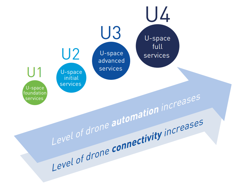

    Image: GSA

  • GNSS receivers track port movements with CORS corrections

    GNSS receivers track port movements with CORS corrections

    The largest seaportS on America’s West Coast are the Ports of Long Beach and Los Angeles, located next to each other in San Pedro, California. (Photo: Art Wager/E+/Getty Images)
    The largest seaportS on America’s West Coast are the Ports of Long Beach and Los Angeles, located next to each other in San Pedro, California. (Photo: Art Wager/E+/Getty Images)

    The Port of Long Beach, California, is moving up and down because it sits on fault blocks that move like pistons due to subsidence caused by oil extraction. To accurately keep track of these movements, the port’s surveyors use GNSS receivers that receive corrections from continuously operating reference stations (CORS) operated by the port and by the City of Long Beach.

    CORS corrections compensate for errors inherent in GPS — clock drift, orbit errors, signal errors and atmospheric errors.

    Monitoring Subsidence. A monitoring receiver is placed on each fault block’s anticline, said Kim Holtz, director of survey for the Port of Long Beach. Her agency has 15 stations, along the coast, and a couple in the Port of Los Angeles. They were installed originally in the 1990s, using Trimble 5700s. “We are constantly monitoring to make sure that the fault blocks are not moving too much and that they are not moving horizontally other than all together, as the plates move to the north,” Holtz said.

    Also, the Long Beach Energy Resources Department has 14 Trimble R9 base stations. While Energy Resources uses the equipment to get precise elevation differences and measure subsidence for movement of more than 0.025 feet, the port uses them mainly for horizontal measurements for construction.

    The port’s hydrographic survey boat, the pilot boats, and the dig alert crew that marks utilities for construction operations also use the receivers to tie into the CORS network. “The stations are about eight or nine years old and Energy Resources is getting ready to replace all of them with Trimble Alloy GNSS reference receivers, over a three-year period,” Holtz said.

    Digital Level Run. The port normally performs a digital level run from a tidal wave base station in San Pedro, which dates to the 1920s. “We run a level run from that and, at the same time, Energy Resources does a GPS subsidence survey, where they get elevation,” Holtz explained. “Last year, we combined the two surveys, to compare the data and see whether we could use some of their GPS data for our level run. It was very promising. We are going to do it again in November.

    “Then, if it works, we will cut our level run, which normally takes two months, down to about a week or two. We will just come off of the main benchmarks on which Energy Resources puts a GPS elevation.”

    To keep the elevations tight, more than 10 years ago Long Beach created its own geoid. “It is a hybrid of GEOID12B, and we’ve updated it a couple of times,” Holtz said.

  • GPS IIR/IIR-M satellite antenna patterns released for worldwide use

    GPS IIR/IIR-M satellite antenna patterns released for worldwide use

    Partnering with the U.S. Coast Guard Navigation Center (NAVCEN), U.S. Space Force and Lockheed Martin Space have released the GPS IIR/IIR-M satellite antenna patterns for worldwide public use.

    Additionally, the Institute of Navigation has offered a related ION journal article free to the public to accompany the antenna patterns.

    The files now available from NAVCEN include:

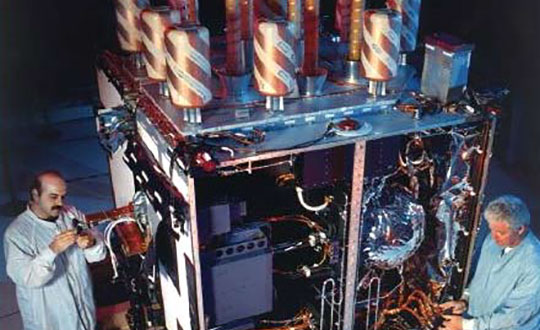
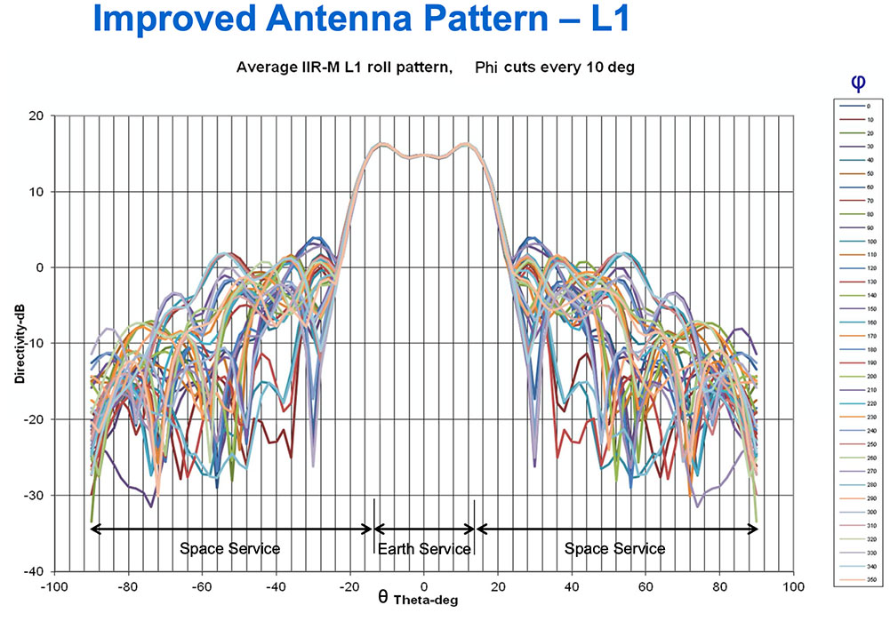
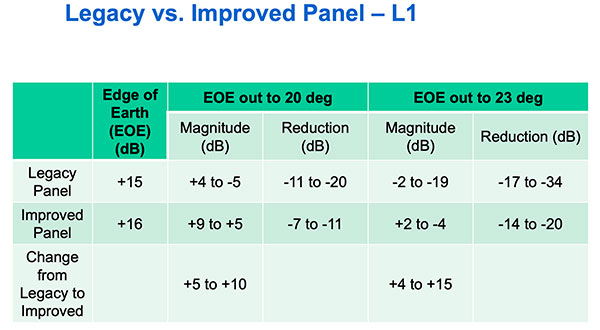
    The GPS Block II Replenishment (IIR) space vehicle (SV) began improving upon its baseline design in 2003 with the launch of the first Block IIR SV retrofitted with a redesigned  antenna panel. This is the Earth-facing panel providing the GPS L-band broadcast signal. The improved antenna panel includes redesigned L-band elements mounted on the SV Earth-facing structure in the same manner as the original antenna panel.

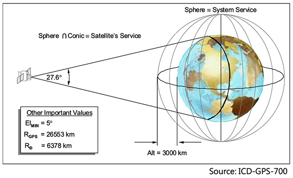
    The Earth Terrestrial Service Volume is the near-Earth region up to 3,000 km altitude. (Diagram: NAVCEN/Lockheed Martin)
    The Earth Terrestrial Service Volume is the near-Earth region up to 3,000 km altitude. (Diagram: NAVCEN/Lockheed Martin)

    Spacecraft Navigation

    The use of GPS signals for spacecraft navigation has increased in general over the last few decades. Navigation employing GPS observations for spacecraft in low-Earth orbit is now considered routine.

    However, the situation is quite different for spacecraft that fly in the Space Service Volume above the GPS constellation, including medium-Earth orbit (MEO), geostationary orbit (GEO) and high-Earth orbit (HEO) satellites, as well as missions to the Moon and beyond.

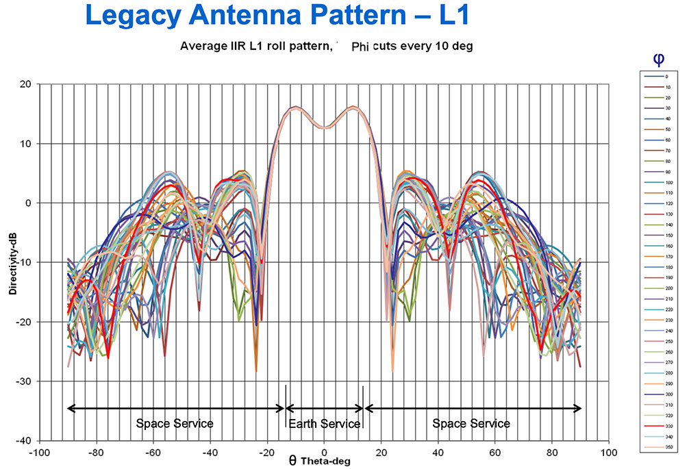
    For these spacecraft, reception of GPS transmit antenna side lobe signals is essential to improve availability and performance of on-board navigation and timing. In this context, the knowledge of the full antenna pattern (main lobe and side lobes) from the transmitting antennas of each of the GPS satellites is essential.

    These published antenna patterns and associated ION citation describe both IIR and IIR-M antenna panel versions, their broadcast signal patterns, the performance observed in factory testing, and their on-orbit performance.

    Chart: NAVCEN/Lockheed Martin
    Chart: NAVCEN/Lockheed Martin
    Chart: NAVCEN/Lockheed Martin
    Chart: NAVCEN/Lockheed Martin
    Chart: NAVCEN/Lockheed Martin
    Chart: NAVCEN/Lockheed Martin

    These patterns represent the current capability of the GPS IIR/IIR-M Space Vehicles. Receiver designers should consult the IS-GPS-200 specifications for use in receiver design and not base design on current signal performance.

    GPS technical documents are also available at the NAVCEN website and linked from the GPS.gov website.

    Legacy antenna panel on the GPS IIR satellite. (Photo: NAVCEN/Lockheed Martin)
    Legacy antenna panel on the GPS IIR satellite. (Photo: NAVCEN/Lockheed Martin)
  • CGI to develop service to alert UK of GNSS disruption

    CGI to develop service to alert UK of GNSS disruption

    The European Space Agency (ESA) has awarded a contract to London-based CGI to develop a GNSS Event Notification Service (GENS) capable of monitoring the United Kingdom (U.K.) GNSS spectrum to enable effective alerting and reporting of position, navigation and time (PNT) disruption.

    GENS will integrate CGI’s PNT Incident Event Monitoring (PNTIEM) system with existing U.K.-developed sensors from Ordnance Survey’s network (OS NET) of GNSS receivers and GMV NSL’s Detector, GISMO and Strike 3 interface technologies.

    Bringing together existing systems will build on proven technologies, reducing the cost of development of a large-scale monitoring network while providing the ability to introduce new services for detecting GNSS events and disruption, according to a CSI press release.

    Supported by the OS and GMV NSL, CGI will lead the delivery of GENS using an agile software delivery experience, supported by system design and DevSecOps development and integration skills. An open interface will be offered for future providers of GNSS measurements or spectrum event data.

    Alongside the GENS system technical delivery, the National Physical Laboratory (NPL) will develop a GNSS guidance document in partnership with U.K. government departments, agencies, CNI operators, professional institutes, academic institutes and commercial organizations to enable informed requirements development, procurement, deployment and support of HMG GNSS-reliant services.

    Reviewed alongside events identified by GENS, the combined offering will highlight and inform stakeholders on risks posed by the loss of PNT services as identified by the PNT Strategy Group Interim Report in April 2020.

    GENS will also respond to HMG’s “Satellite-derived time and position: a study of critical dependencies” report which identified the need for mitigation to GNSS disruption and estimated the economic impact to the U.K. economy of a five-day disruption to GNSS at £5.2 billion.

    The full GENS system will enable users across both commercial and public sector services to subscribe to be informed of both GNSS quality and interference events for regions of interest. By focusing on these events and the improved understanding of the risk posed by disruption, stakeholders will be better informed to enable them to build system resilience or to respond to the disruption of GNSS within the U.K.

    ‘‘Detecting and monitoring GNSS is core to better understanding the scale and risk posed by PNT disruption in the U.K. and across all ESA member states,” said Rafael Lucas Rodriguez, technical officer for GENS, European Space Agency. “ESA is supporting CGI to develop effective tools enabling a system to be created utilizing previous ESA and UK HMG work. This will bring direct benefits for U.K. public and private stakeholders.”

    “The U.K. is a leading investor in GNSS research,” said Andy Proctor, U.K. lead delegate to the ESA Programme Board for Navigation. “Understanding GNSS spectrum quality is vital for the stability of PNT services in the U.K. This program will help promote and address GNSS disruption affecting PNT services while supporting the U.K.’s thriving space sector and the wider economy.”

    “This is an exciting project that brings together CGI’s navigation and spectrum domain expertise supported by scaled agile and DevSecOps delivery experience,” said John Hanley, vice president of secure and assured space solutions at CGI in the U.K. “After talking to both public and private stakeholders for GNSS, it became clear that one of the initial challenges is understanding the scale of PNT disruption. GNSS services touch every part of society across finance, utilities, transport and defense and need to be protected.”

    CGI has been delivering complex, mission-critical space software systems for clients across Europe, Asia and North America, supporting satellite navigation, communications, operations and space enabled applications for more than 40 years.


    Feature photo: alice-photo/iStock/Getty Images Plus/Getty Images

  • Emcore’s EN-300 FOG IMU in high-rate production

    Emcore’s EN-300 FOG IMU in high-rate production

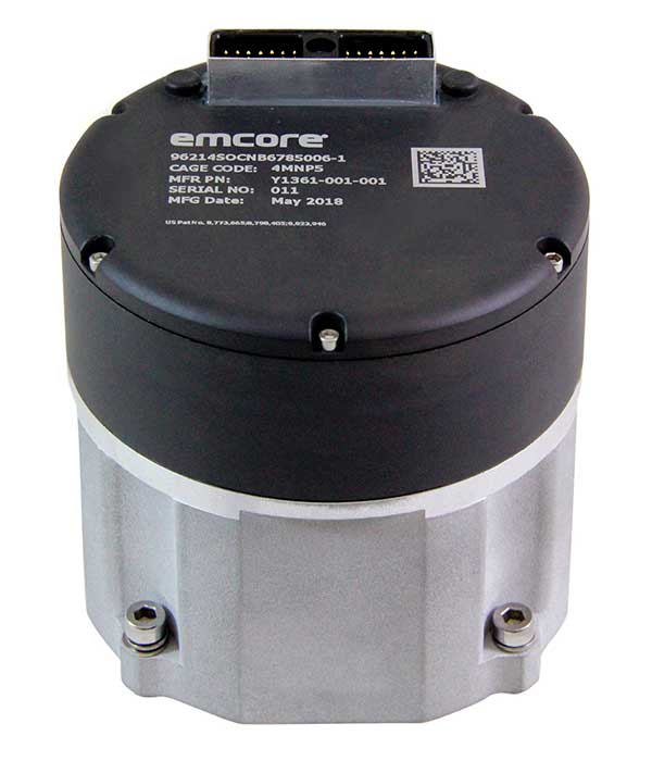
    EN-300 Precision Fiber Optic IMU/INS (Photo: Emcore)
    EN-300 Precision Fiber Optic IMU/INS (Photo: Emcore)

    Emcore Corp.’s EN-300 FOG (fiber optic gyro) inertial measurement unit (IMU) is now in high-rate production and is broadly available for purchase with 12-week lead times. The EN-300 was announced in April.

    Based in Alhambra, California, Emcore providees advanced mixed-signal products that serve the aerospace, defense and broadband communications markets.

    Emcore’s EN-300 offers up to 10 times the bias performance of legacy systems in a form, fit and function compatible package, the company said. This improved performance makes the EN-300 suitable for GPS-denied navigation, precise targeting and line-of-sight stabilization requirements for unmanned aerial vehicles as well as other demanding applications.

    Emcore has successfully completed a comprehensive Design Verification Testing (DVT) regimen over tough environmental conditions and has provided numerous proof-of-technology IMUs globally to defense contractor primes and aerospace customers seeking to upgrade their platforms and systems. Emcore is now expanding production of the EN-300 with strict manufacturing process and quality controls in place to enhance on-time delivery and specification compliance.

    “Given the strong market interest and demand, we are extremely pleased to announce the production ramp-up and broad availability for purchase of the EN-300,” said David Hoyh, Emcore’s director of sales & marketing for navigation products. “Emcore’s vertical integration creates unique capabilities that enable us to deliver the higher level of performance demanded by the market, coupled with greater precision and lower cost to further benefit our customers.”

    According to Emcore, the EN-300 precision FOG IMU is a three-axis, closed-loop design using the Company’s proprietary, solid-state FOG transceiver with advanced integrated optics, offering improved reliability and lower cost than legacy IMUs. It can be ordered with performance options tailored to specific customer requirements.

    The COTS (commercial off-the-shelf) EN-300-3 model achieves bias in-run stability as low as 0.04 degree/hr with ARW (Angle Random Walk) of 0.015 degree/rt-hr. The non-ITAR EN-300 is superior in performance to older generation such as the closed-loop LN-200 IMU or open-loop KVH 1750 series IMU units that have higher bias over temperature drift.

  • Quantum Reversal adds new GNSS anti-jam units to product offerings

    Quantum Reversal adds new GNSS anti-jam units to product offerings

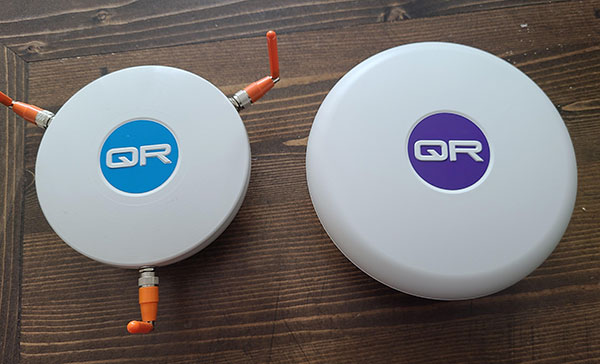
    The QR100 and QR201 anti-jamming devices. (Photo: Quantum Reversal)
    The QR100 and QR201 anti-jamming devices. (Photo: Quantum Reversal)

    Quantum Reversal has added several new models to its flagship anti-jamming line. The company introduced in February the QR100 L1/L2 GPS anti-jamming unit and the QR101 L1/L2 GPS anti-jamming antenna.

    The current solution consists now of five products designed for the commercial market to solve the issue of unintentional RF interference or jamming:

    • QR100 – GPS dual frequency L1/L2 anti-jamming unit
    • QR200 – GPS dual frequency L1/L2 anti-jamming antenna
    • QR101 – GNSS multi frequency bands anti-jamming unit
    • QR201 – GNSS multi frequency bands anti-jamming antenna
    • QR202 – GNSS multi frequency band anti-jamming antenna with additional L-band reception
      (1520-1560 MHz)

    All models provide robust GPS or GNSS navigation solution, blocking intentional jamming and unintentional RF interference for services such as timing or 3D positioning.

    All the products are lightweight (230 grams for QR1xx series and 500 grams for QR2xx series) with low power consumption (1-1.5 Watt typically, depending on the configuration), and can be mounted on any platform (cars, poles, drones, etc.).

    Quantum Reversal operates in the information and wireless technology sector, developing innovative wireless and antenna technologies for various commercial markets. The QR team has experience designing products for applications in space, underwater, robotics and unmanned aerial vehicles (UAVs) for the commercial and user end. Each application requires a specific solution to deal with specific environmental (pressure, temperature, vibration, etc.) and operational conditions.

    The company sells stand alone products as well as OEM products that can be integrated within the customer products.

  • Inertial Labs launches Kernel-100 IMU with MEMS sensors

    Inertial Labs launches Kernel-100 IMU with MEMS sensors

    Photo: Inertial Labs
    Photo: Inertial Labs

    Inertial Labs is offering a new industrial-grade inertial measurement unit (IMU) for aerospace and defense applications, among others.

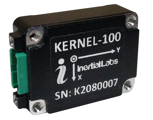
    The Kernel-100 is a compact, self-contained strapdown IMU that measures linear acceleration and angular rates with three-axis MEMS accelerometers and three-axis MEMS gyroscopes.

    The Kernel-100 is fully calibrated, temperature compensated, mathematically aligned to an orthogonal coordinate system. It contains up to 2 deg/hr bias in-run stability gyroscopes and 10 μg bias in-run stability accelerometers with extremely low noise and high repeatability.

    The Kernel-100 is a fully integrated inertial solution that includes the newest MEMS sensor technologies. With seamless integration, the Kernel-100 inertial system is a cost-effective high performance yet compact and low-power IMU, the company said. The Kernel-100 is easy to integrate in a wide range of higher order systems while consuming very little space and power.

    With continuous built-in test (BIT), configurable communications protocols, electromagnetic interference protection, and flexible input power requirements, the Kernel-100 is built to be used in a wide variety of environments and integrated system applications.

    Built for air, marine and land environments, the Kernel-100 can be integrated into motion reference units, attitude and heading reference systems, and GPS-aided inertial navigation systems. As a result, the Kernel-100 is suitable for a wide variety of applications such as autonomous vehicles, antenna and line-of-sight stabilizations systems, and buoy or boat motion monitoring.

    Inertial Labs provides innovative solutions to commerce, industry and government for defense and aerospace.

  • Swift Navigation’s SSR service now available across 2 continents

    Swift Navigation’s SSR service now available across 2 continents

    Image: Swift Navigation
    Image: Swift Navigation

    Swift Navigation has launched its production-grade SSR (state space representation) service across Swift’s coverage areas.

    Swift is a San Francisco-based tech firm offering GNSS and precise positioning technology for mass-market applications in autonomous vehicles, mobile and internet of things (IoT).

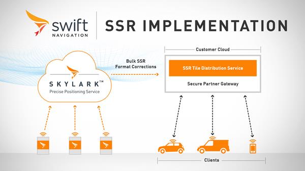
    SSR is a bandwidth-efficient format to deliver GNSS corrections to mass-market applications, such as for automotive and mobile customers. It is offered through Swift’s Skylark precise positioning service.

    As a new option for corrections delivery available as part of Swift’s precise positioning service, SSR delivers seamless and homogeneous accuracy throughout a coverage area. To date, Skylark delivered corrections in OSR (observation state representation) format for compatibility with legacy equipment but with the introduction of SSR, the power of Swift’s cloud error modeling is now available in its native format.

    SSR provides users with fine-grained information about GNSS error sources. SSR divides the coverage region into a series of “tiles” which can be broadcast to all users within that tile, enhancing scalability and minimizing bandwidth while maintaining the utmost security and privacy.

    With the capacity to reach millions of connected devices in markets such as mobile and automotive, it is critical to provide both a scalable and secure solution. Swift’s Skylark can deliver bulk corrections data to enterprise customers’ backend for distribution, putting the customer in control of their own users’ privacy and security.

    Swift’s enterprise-reference architecture code equips customers with the SSR Tile Distribution Server software that provides a seamless integration path to incorporate SSR corrections into their own cloud or on-premise solution.

    Swift’s SSR solution is also based on the open standard from 3GPP. The significance of utilizing the SSR positioning standard from the 3GPP standards body is that it meets the interoperability requirements demanded by mass-market mobile and automotive applications.

    “The team at Swift is excited to bring its production-grade, standards-based SSR service to market,” shares Fergus Noble, CTO at Swift Navigation. “The ability to deploy SSR to users in a scalable way, while maintaining privacy, makes it possible for automotive, cellular and IoT mass-market customers to integrate precise positioning into their service offering.”

    Skylark is available for integration into wide-area, high-precision positioning applications across the continental United States and Europe and is available in the countries of Japan, South Korea and Australia, with plans to expand globally. Skylark is an ever-expanding service and is scalable to service millions of users. All eligible Skylark subscribers begin with a free trial or pilot program.

  • Guiding an unmanned vessel

    Guiding an unmanned vessel

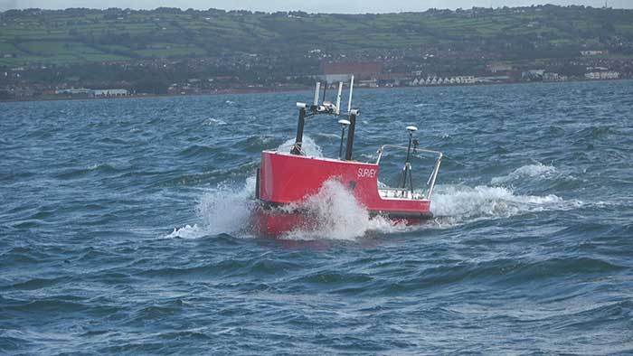
    U.K.-based Unmanned Survey Solutions (USS) has created a unique unmanned surface vessel called the Accession Class USV. It’s modular design offers three variable boat lengths depending on the desired application. The base boat length of 3.5 m can be extended to 4.25 m or 5 m by adding additional hull sections.

    The standard USV configuration includes sensors for meeting International Hydrographic Organization (IHO) special-order surveys. The sensors consist of an R2Sonic SONIC 2024 multibeam sonar; an SBG Apogee Navsight Inertial + GNSS solution, and a Valeport MiniSVS and Swift SVP for measuring sound velocity.

    Image: Unmanned Survey Solutions
    Image: Unmanned Survey Solutions

    The data is acquired in either Hypack or QINSy hydrographic software and used for mission planning, data acquisition, post processing and final products. Designed for operations in both nearshore and offshore environments, the autonomous platform is safer and more cost-effective than comparative manned vessels, USS said.

    Image: Unmanned Survey Solutions
    Image: Unmanned Survey Solutions

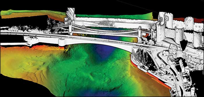
    Although the Accession USV is payload agnostic and fully customer configurable, the standard configuration can also be interfaced with a mobile lidar such as the Carlson Merlin laser scanner for mapping terrestrial structures to create a full 3D point cloud above and below the water. This is achievable because of the embedded SBG inertial navigation system (INS), which is extremely versatile for both shallow or deeper water regions as well as challenging GNSS environments such as under bridges. In such situations, the centimeter-level RTK position accuracy is greatly improved using the SBG’s Qinertia post-processing software. This PPP- and PPK-capable software offers single or virtual base-station modes and can even incorporate users’ own base-station RINEX data.

    “Not only did we want to create an autonomous vessel specifically for surveyors, but we also wanted to incorporate the latest advanced sensor technologies,” said James Williams, USS director. “It was also extremely important that the final combined solution had a low CO2 footprint and was more cost effective than similar manned vessels.”

  • U-blox provides LPWA IoT security to system engineers

    U-blox provides LPWA IoT security to system engineers

    Image: metamorworks/iStock/Getty Images Plus/Getty Images
    Image: metamorworks/iStock/Getty Images Plus/Getty Images

    U‑blox has launched a commercial internet of things (IoT) Security-as-a-Service offering. Available on both the u‑blox SARA-R4 and SARA-R5 series of LTE-M cellular IoT modules, the service protects data from malicious third parties, both on the device and during transmission from the device to the cloud, u-blox said in a press release.

    Both the SARA-R4 and R5 have integrated M8 GNSS receivers.

    The IoT Security-as-a-Service provides an out-of-the box onboarding process to cloud IoT platforms to speed up development, shortening time-to-market.

    The IoT Security-as-a-Service offering, which is managed via the u‑blox Thingstream service delivery platform, is specifically optimized for low-power, wide-area (LPWA) deployments that use resource-constrained IoT devices. By substantially reducing data overhead and keeping the number of handshakes to a minimum, the service improves power consumption and extends the battery life, a critical metric for most IoT devices.

    u-blox acquired Thingstream, an IoT communication-as-a-service provider, in April.

    Central to the effectiveness of the solution is a unique symmetric key management system (KMS). Through it, an infinite number of crypto keys can be generated on the fly for each device, rather than having to rely on the storage and management of pre-shared keys (which can add to overall operational complexity and the power budget).

    Keys are tied to the hardware and can be triggered from either the module or from the server/cloud, completely eliminating the need to create, deliver, and renew certificates, and bringing significant savings in terms of system cost, operational complexity, and power consumption.

    The solution also leverages u‑blox’s Foundation security offering, which comprises fundamental elements that make SARA-R4 and SARA-R5 modules secure by design. These include a unique and immutable device identity that is tied to its root of trust (RoT), which forms the basis for a trusted set of advanced security functionality, including a secure boot mechanism that ensures that the module can only run trusted software. In addition, u‑blox’s proprietary uFOTA feature enables authentication of over-the-air firmware updates.

    Among the relevant use cases that u‑blox IoT Security-as-a-Service can support are:

    • Asset tracking. Data authenticity is essential in such scenarios, as well as secure local storage of collected data and easy secure cloud onboarding. Because tracking devices are usually battery powered, they require extremely energy-efficient secure data transmission.
    • Connected health/eHealth. In this use case, patient confidentiality is paramount, with only authorized medical staff permitted to access sensitive data. This necessitates a high degree of protection against malware and data tampering.
    • Industrial monitoring. These solutions need to guarantee the integrity of real-time operational data to increase productivity, avoid downtime, and assure the safety of the workforce.
    • Building and home automation. Data confidentiality and authenticity need to be maintained, while allowing for data to be shared with trusted stakeholders without compromising customer privacy.
    • Telematics. In this scenario, the main security risks include denial-of-service (DoS) attacks, device cloning, jamming, etc.
    • Smart metering. Here, the authenticity of data logged by remote metering units needs to be confirmed to protect billing, and, once trusted communication is established, data transmission needs to be restricted to authorized servers.

    “We implemented a true end-to-end concept that protects data from the device to the end user without making it visible to intermediate nodes or platforms, or to service providers. The modules’ symmetric KMS offers engineers a streamlined and scalable alternative to conventional public key infrastructure or pre-shared key arrangements,” says Giovanni Solito, senior product manager, Product Center Services at u‑blox. “And with straightforward onboarding to all the popular cloud IoT platforms, efforts are not taken up by security concerns and operational complexities, but can be focused on speeding up time to market and growing business.”

  • New Taoglas antennas aimed at robotics, autonomous vehicles

    New Taoglas antennas aimed at robotics, autonomous vehicles

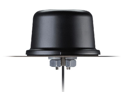
    Taoglas has unveiled active, multiband GNSS antennas engineered for applications that require critical high-accuracy positioning and timing, including autonomous driving and precision agriculture. Both the MagmaX2 AA.200 and Colosseum X XAHP.50 add to Taoglas’ high-precision GNSS range.

    “Safety standards for autonomous vehicles (UAVs, robotics and vehicles) and precision agriculture is an ever evolving arena,” said Ronan Quinlan, co-CEO and founder of Taoglas. “However, it’s increasingly apparent that high-precision positional accuracy is critical for both. At Taoglas we’re continuously innovating our GNSS antennas to deliver the very best precise location capabilities, but in more lightweight, compact structures, compared to larger counterparts already on the market. We look at the impact the antenna has on the actual positioning performance of your system, not just the antenna itself.”

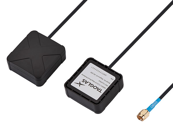
    The MagmaX2 AA.200. (Photo: Taoglas)
    The MagmaX2 AA.200. (Photo: Taoglas)

    The MagmaX2 AA.200 is designed for space and weight constrained applications, such as robotic lawnmowers, Quinlan said. Embedded antenna versions are also available.

    The AA.200 is a low-profile active multiband GNSS magnetic mount antenna for use across most major constellations including GPS (L1/L2/L5), GLONASS (G1/G2/G5), Galileo(E1/E5a/E5b) and BeiDou(B1/B2). It exhibits excellent gain and good radiation pattern stability leading to a reliable GPS fix in areas of weaker signal strength.

    Positional accuracy better than 60 cm (DRMS) is achievable, even without RTK corrections services. Accurate positioning down to 1.4 cm has been demonstrated with today’s multiband GNSS receivers and RTK services in the field.

    The Colosseum X XAHP.50 antenna. (Photo: Taoglas)
    The Colosseum X XAHP.50 antenna. (Photo: Taoglas)

    The Colosseum X XAHP.50 is a geodetic-quality small-dome antenna suitable for a vehicle roof mount or pole mount. “Every element and aspect of the antenna performance has been optimized during the design of this antenna,” Quinlan said. “This includes many deep interlocking rf parameters for true accurate centimeter-level positioning, compared to legacy meter-only level systems. Phase center variation, group delay, multipath rejection, axial ratio over angle all become critical considerations and performance targets.”

    The XAHP.50 is engineered to operate with incredibly high precision capabilities on the full GNSS spectrum. Sub meter positional accuracy better than 55cm (DRMS) is achievable, even without the use of RTK correctional services. This allows the user to achieve higher location accuracy, as well as stability of position tracking in urban environments.

    The XAHP.50 has excellent performance across the full bandwidth of the antenna and its design has an even gain across the hemisphere giving excellent, broad axial ratio which in turn makes it resilient to multipath rejection and excellent phase centre stability. Accurate positioning down to 1.4 cm has been demonstrated with today’s multiband GNSS receivers and RTK services in the field.

    Antenna Development

    “In the design phase we simulate using electromagnetic analysis software and tweak every parameter,” Quinlan said. “Once we are happy with the results, we build our prototypes and test in scientifically controlled chamber and test environments validated by the European Space Agency, with repeatable GNSS signals.

    “We then move onto field testing in open-sky conditions and in non-line of sight environments to verify real-world performance with today’s state-of-the-art receiver systems from such leading companies as u-blox and Septentrio.

    What’s more, every single antenna coming off our production line goes through strict in-line sensitivity testing to ensure consistent validated performance. We take our commitment to quality and safety very seriously in the coming age of autonomous operation,” Quinlan concluded.

  • L3Harris to help DOD with artificial intelligence, machine learning

    L3Harris to help DOD with artificial intelligence, machine learning

    Logo: L3HarrisL3Harris Technologies will help the U.S. Department of Defense (DOD) develop artificial intelligence and machine learning (AI/ML) systems to help reduce the amount of time it takes to decipher usable intelligence from increasing amounts of data collected from space and airborne assets.

    L3Harris will research, develop and demonstrate an AI/ML interface using data science techniques under a new multimillion-dollar contract to support DOD applications.

    “L3Harris’ work will allow the DOD to turn massive volumes of data into actionable intelligence,” said Ed Zoiss, president, Space and Airborne Systems, L3Harris. “The abundance of data collected by space and airborne assets is only increasing. The findings of this research will directly address the data processing challenges within the DOD and intelligence community.”

    Awarded by the U.S. Army Research Laboratory, the contract supports the DOD’s initiative to accelerate the integration of big data and AI/ML within the agency.

    L3Harris will perform the work in Rochester, New York; Melbourne, Florida; and Herndon, Virginia.