Blog

  • UAVOS control system for HAPS takes on unstable air

    UAVOS control system for HAPS takes on unstable air

    Photo: UAVOS
    Photo: UAVOS

    UAVOS Inc. has performed a series of successful flight trials with High Altitude Pseudo Satellite (HAPS) ApusDuo, testing its unique control system.

    The test flights confirmed that UAVOS’s control system allows aircraft with a large-wing elongation to fly in unstable atmospheric conditions. The ApusDuo aircraft successfully copes with turbulence, actively changing the bend of the wings.

    The total flight time of UAVOS solar-powered test aircraft is more than 1,000 hours. Test flights took place at an altitude of up to 62,000 feet (19,000 meters).

    UAVOS’s control system does not require the installation of wing mechanization. This reduces the aircraft’s weight by 30% or more, improves reliability and simplifies wing production for lower manufacturing costs.
    The ApusDuo drone weighs about 95 lbs (43 kg) and has a wingspan of 49.2 ft. It is launched by a winch. The aircraft is built on the tandem principle, where two of the wings are located one after another with a small elevation difference.

    ApusDuo is controlled by changing the geometry of the aircraft. It is designed to linger at an altitude of about 60,000 feet (18,000 m) for months at a time for surveillance or to provide a temporary boost to communications.

    Additional test flights are planned for this year, said Aliaksei Stratsilatau, UAVOS CEO and lead developer.

    In July, UAVOS became a member of the HAPS Alliance, which aims to accelerate commercial adoption of HAPS technologies.

  • Dead-end? Robotic platoon can now reverse with trailers attached

    Dead-end? Robotic platoon can now reverse with trailers attached

    Photo: Robotic Research
    Photo: Robotic Research

    Robotic Research LLC has added Retrotraverse to its AutoDrive-M autonomy kit. The autonomy kit is equipped on the U.S. Army’s Palettized Load System (PLS) logistics trucks.

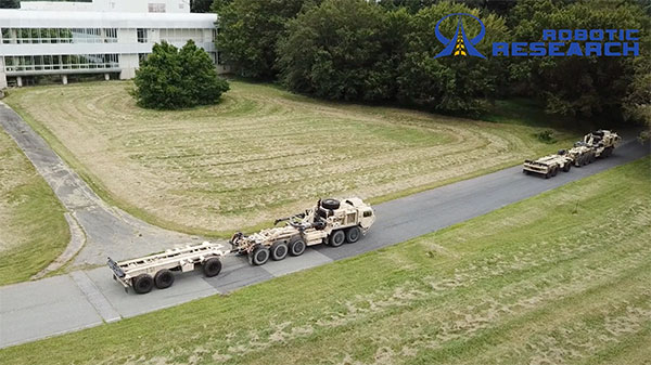
    Robotic Research demonstrated the Retrotraverse capabilities with three of the U.S. Army’s PLS trucks, each towing trailers. “This is a major step forward for our company and has broad application both in autonomy and platooning. The capability solves the potentially life-threatening problem of an autonomous platoon of military vehicles being unable to navigate out of a dangerous situation,” said Alberto Lacaze, president of Robotic Research. “This automated platooning capability will ultimately extend the reach of soldiers without putting them in harm’s way.”

    The Retrotraverse feature allows a platoon of heavy-duty trucks with trailers to autonomously reverse. Several autonomous vehicle providers in the trucking industry are demonstrating platooning in benign conditions, where the weather is ideal and road surfaces are smooth and marked.

    Robotic Research has been specifically focusing on addressing the edge cases, such as poor weather, dust and off-road conditions, to ensure a robust autonomous system that is necessary for operating in all conditions and during mission-critical operations for the military.

    If a platoon drives into a dead end, or similar edge case where it cannot make a U-turn, the platoon of vehicles with trailers needs to be able to reverse out of the situation. Retrotraverse can make this happen.

    “Anyone who has backed up a truck with a trailer knows how difficult it is to navigate,” said Joe Putney, director of commercial systems at Robotic Research. “The autonomous Retrotraverse feature was able to reverse a truck and trailer faster than even our most skilled drivers. This feature is not just lifesaving, it’s time-saving, and it has the ability to reduce one of the greatest pains truck drivers have.”

    In 2018, Robotic Research was awarded a three-year, $49.7 million contract by the U.S. Army to provide its autonomy kit for large convoy resupply vehicles. Robotic Research has since delivered nearly 100 unmanned platooning trucks.

  • Javad offers RTPK option for surveyors with Triumph-LS

    Javad offers RTPK option for surveyors with Triumph-LS

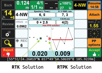
    Javad GNSS introduced a new solution, Real-Time Post-processed Kinematics (RTPK), at Intergeo Digital 2020.

    With the new option, the Javad Triumph-LS combines the strengths of RTK and PPK into a system that can post-process RTK data and verify its results in parallel and real time.

    If RTK fails, RTPK is available in a fraction of a second, the company said.

    Screenshot: Javad GNSS
    Screenshot: Javad GNSS

    “The RTPK feature is about as simple as any feature can get,” said Darren Clemons, PLS. “When you are on a point and stop the session, the LS automatically starts downloading the data for the time period matching that session from your base (or RTN) and then internally in the LS (no internet connection required) runs the post processing and gives you the PPK solution right there on your point in real time. […] It is a very nice and ingenious feature and, for us anyway, is a great check on our RTK results.”

  • Aceinna, Point One Navigation partner for precise positioning

    Aceinna, Point One Navigation partner for precise positioning

    Photo: Aceinna
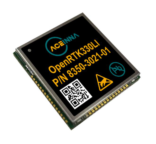
    The Aceinna OpenRTK330. (Photo: Aceinna)

    Aceinna, a developer of inertial-based guidance and navigation systems for autonomous vehicles and devices, has partnered with Point One Navigation, which delivers precise positioning for the next generation of transportation.

    According to the companies, the partnership enables a streamlined positioning platform that combines Point One’s Polaris GNSS cloud correction service with Aceinna’s OpenRTK330 hardware and software solution for developers in agriculture, construction, mapping, surveying, robotics and trucking.

    OpenRTK330, designed for use in Level 3 ADAS and other high-volume applications requiring precise position information, is a GNSS receiver with a built-in RTK engine and triple redundant inertial sensors. According to Aceinna, it includes a multi-band RTK/GNSS receiver coupled with redundant inertial sensor arrays to provide centimeter-level accuracy, enhanced reliability and superior performance during GNSS outages. OpenRTK300 is supported by Aceinna’s open-source tool chain.

    Through backend server synchronization between the companies, activation and authentication will be streamlined. In addition, true centimeter-level accuracy will be attainable and powered by the integration of Point One’s coast-to-coast Polaris network and Aceinna’s OpenRTK platform, the companies said.

    “This partnership between Aceinna and Point One harnesses and combines each of our distinct strengths, to offer a solution platform that makes high performance positioning accessible to a variety of industries and applications,” said Yang Zhao, chairman and CEO of Aceinna. “We are thrilled to work with Point One’s technical expertise and execution to advance this technology to the next level of precision.”

    The combined offering will be available for purchase beginning December 2020.

    Aceinna is headquartered in Andover, Massachusetts, and Point One Navigation is headquartered in San Francisco.

  • Smart agriculture market estimated to reach $29M by 2027

    Smart agriculture market estimated to reach $29M by 2027

    Photo: artiemedvedev/iStock / Getty Images Plus/Getty Images
    Photo: artiemedvedev/iStock / Getty Images Plus/Getty Images

    The global smart agriculture market size was valued at $16,747.7 million in 2019 and is estimated to reach $29,234.6 million by 2027, with a CAGR of 9.7% from 2021 to 2027, according to Valuates Reports.

    The market is expected to rise as a result of rising population, increasing strain on the food supply system, the growing use of new technology in agricultural products and farmers’ growing focus on tracking livestock.

    According to the report, the global competition between players will be increased by new players joining the global smart agriculture market, which will in turn increase advancements in technology. Top companies in the smart agriculture market include Trimble, Deere & Co., Topcon Positioning Systems, DeLaval, AgEagle Aerial Systems, Afimilk, Raven Industries, Ag Junction, AGCO Corporation and GEA Group, the report said.

    Current trends influencing smart agriculture market size include the growing adoption of automation and control systems, such as GPS/GNSS receivers, irrigation controllers, and guidance and steering systems, has created a new approach to farming practices. The report said it also expects growing investment, R&D spending on agricultural technology and increased popularity of land-based recirculating aquaculture systems to fuel market growth.

    The report also touched on COVID-19’s impact on the smart agriculture market, noting the market is expected to see a marginal fall in 2020 as movement restrictions and lockdowns have led to supply chain disruptions.

    Despite this, the precision farming segment held the largest market share in 2019 and is expected to retain its dominance during the forecast period, the report said. North America is expected to hold the largest smart agriculture market share during the forecast period, and Asia Pacific is expected to witness the highest growth during the forecast period.

  • DJI unveils integrated lidar drone solution, camera payload

    DJI unveils integrated lidar drone solution, camera payload

    DJI unveiled two new solutions at Intergeo 2020: the DJI Zenmuse L1 lidar solution for aerial surveying and DJI Zenmuse P1 camera payload. (Photo: DJI)
    DJI unveiled two new solutions at Intergeo 2020: the DJI Zenmuse L1 lidar solution for aerial surveying and DJI Zenmuse P1 camera payload. (Photo: DJI)

    DJI has debuted two payload solutions for its flagship commercial drone platform Matrice 300 RTK: the DJI Zenmuse L1 and DJI Zenmuse P1. The solutions were unveiled at Intergeo 2020.

    DJI Zenmuse L1

    The Zenmuse L1 is DJI’s first lidar solution for aerial surveying. DJI Zenmuse P1 integrates a Livox lidar module with a 70-degree FOV, a high-accuracy IMU, and a 20-megapixel camera with a 1-inch CMOS sensor and a mechanical shutter on a 3-axis stabilized gimbal.

    According to DJI, the Zenmuse L1, which has a point rate of 240.000 points per second and a detection range of 450 meters, can generate true-color point cloud models in real-time, or acquire a vast area (up to 2 km2) of point cloud data in a single flight. The module supports both line scan mode and non-repetitive scanning mode.

    When used with DJI’s flagship commercial drone platform Matrice 300 RTK and DJI Terra surveying software, it becomes a complete and versatile solution that gives the user real-time 3D data throughout the day, efficiently capturing the details of complex structures and delivering highly accurate reconstructed models, DJI said.

    DJI Zenmuse P1

    The DJI Zenmuse P1 camera payload integrates a 45-megapixel full-frame low-noise high-sensitivity sensor offering flexible viewing with interchangeable 24/35/50mm fixed-focus lenses on a 3-axis stabilized gimbal.

    According to DJI, the Zenmuse P1 is equipped with a TimeSync 2.0 system, which synchronizes time across modules at the microsecond level. It features a smart oblique camera feature that helps improve efficiency by only capturing the photos essential to the reconstruction at the edge of the mapping areas. DJI Zenmuse P1 also integrates a 45-megapixel full-frame low-noise high-sensitivity sensor.

    “With these two new payloads, we are providing an all-integrated complete solution to our enterprise customers active in accurate geospatial data acquisition,” said Arjun Menon, engineering manager at DJI in the U.S. “Having a fully integrated capable and affordable lidar seamlessly integrated into our best commercial drone is a dream that becomes reality for surveying, mapping and construction professionals. They will be able to see, cover and understand the geospatial context from a totally new perspective thanks to the high level of accuracy and quality of the data collected from these tools in the sky.”

  • GNSS simulator companies help pilots find their way

    GNSS simulator companies help pilots find their way

    Flight simulators range in price from free to tens of millions of dollars and in purpose from pure entertainment to serious business — such as learning to fly multi-million-dollar aircraft without crashing them in real life and getting anyone killed. Military and commercial pilots spend thousands of hours in simulators learning both routine operations and how to deal with emergency situations. They can become fully proficient through immersive training in these virtual environments. The U.S. Army, Air Force, Navy and Marines all use flight simulators to train pilots to fly in battle, recover in an emergency, and coordinate air support with ground operations. To do this, they use hardware and software developed both by military agencies and by commercial military contractors.

    In high-end flight simulators, the trainee steps into a life-size replica of a cockpit, whereas others consist of several monitors that cover the trainee’s field of view, or, at the lowest end, everything is crammed onto a single monitor. All flight simulators, however, are designed to replicate as closely as possible the layout and controls of a real aircraft. (Ironically, the $120 Microsoft Flight Simulator Premium Deluxe Edition lets you fly 35 different planes, while flight simulators that cost tens of millions of dollars are limited to a few models because they have to physically replicate the cockpit layout, which varies from aircraft to aircraft. Some training centers invest in multiple simulators, while others privilege convenience over accuracy and use a single simulator model.)

    Most professional flight simulators sit on top of either an electronically-controlled motion base or a hydraulic lift system that rotates the replica cockpit in three dimensions in reaction to both user input and simulated events. This provides trainees with haptic feedback, in other words, feedback they can feel. (Another example of a device that provides haptic feedback is a joystick with force feedback.)

    Like when learning to sail offshore or to survive in the wilderness, a large component of any pilot training program is navigation. For flight simulators, this involves detailed aeronautical charts, huge amounts of Earth observation imagery including thousands of airports, and faithful replicas of several cockpit navigation instruments. While aviation programs provide standard training to ensure pilots can handle situations ranging from enemy fighters to bird strikes to engine failure, they may overlook the importance of duplicating actual cockpit instruments rather than relying on facsimile ones.

    Simulating GNSS signals

    This is where GNSS simulators come into play. They make it possible “to simulate the actual GPS signal required by the cockpit navigation instruments,” according to a case study by Orolia.

    This approach, the company points out, offers advantages to both the trainees who use flight simulators and the engineers who develop them. For a trainee, “the advantage is that he is trained using the identical instruments as those in the actual airplane […] providing the same feedback as a real-world experience.” For an engineer developing a flight simulator, GNSS simulators make it possible to “design more effective flight simulation programs without compromising quality.”

    Furthermore, “using real navigation instruments may […] reveal unexpected behavior from the instrument, which helps the pilot to be prepared for this possibility. If any conditions involving the plane dynamics are not properly handled by the navigation unit, the pilot can obtain actual feedback from real navigation instruments, which could differ from feedback provided by a facsimile instrument.”

    Hardware-in-the-loop (HWIL) techniques enable Orolia to integrate its simulator in a flight simulator to reproduce the GPS/GNSS dynamics for the airplane in real time. “Because the pilot steers the aircraft in real time, the GPS simulator must also simulate GPS signals in real time, forming an HWIL integration,” the company said. “This integration enables the flight simulator to integrate the actual navigation unit to provide a very realistic environment for the trainee.”

    Racelogic, another manufacturer of GNSS simulators, is launching a new RealTime LabSat that can connect to Microsoft Flight Simulator, including the new 2020 version. “This will create a live GNSS RF feed that accurately follows the trajectory in the simulator, enabling the testing of any GNSS device as though it were being flown on the aircraft,” said Julian Thomas, the company’s managing director. “To help make this a cost-effective solution, we have recently optimized our SatGen signal simulation software so that a real-time simulation such as this can be carried out on an entry-level PC with a full constellation of simulated satellites.”

    The GNSS and flight simulation industries overlap even further. For example, Garmin, which manufactures consumer GPS receivers, makes the avionics used in some professional flight simulators.

    Simulator demand on the rise

    The utility of simulators is not limited to training human pilots and drivers. The demand for simulation is being sharply increased by the development of autonomous vehicles of every kind — from self-driving cars to unmanned aerial vehicles (UAV), from bathymetric vessels to urban air mobility (UAM) aircraft.

    For example, manufacturers of self-driving cars need to simulate driving millions of miles, in all kinds of traffic and weather conditions, to perfect their vehicles’ algorithms. The result of all these simulations is better trained human and robotic pilots and drivers prepared for real situations, superior mission readiness, and maximum safety for both military and civilian operations on land, at sea and in the air.


    Feature image: In a simulated G1000 NXi integrated flight deck for a King Air 350, a pilot refers to the Garmin Pilot app, used as a supplement during flight. (Photo: Garmin)

  • New Topcon robotic total station system built for survey and construction workflows

    New Topcon robotic total station system built for survey and construction workflows

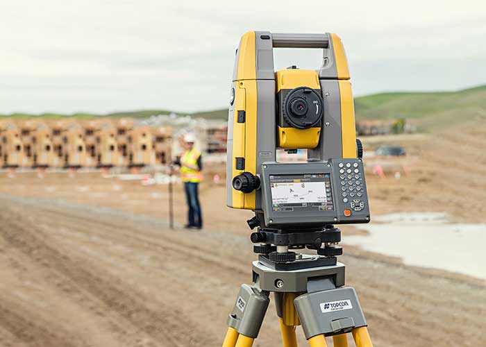
    According to Topcon, the new total stations are part of a full workflow solution. (Photo: Topcon)
    The GT-1200 robotic total station (Photo: Topcon)

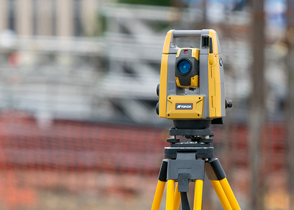
    Topcon Positioning Group has debuted a new series of robotic total stations for survey, construction and machine control applications. The GT-1200 and GT-600 total stations are available in multiple accuracy levels.

    The new the GT series of total stations are part of a full workflow solution, including a new field computer, a full-version update to Topcon field and office software and GNSS receivers. The system is designed to work in sync for improved performance and better data handling with built-in, field-to-office connectivity.

    The speed, tracking and accuracy of the GT series, combined with the intuitive software system, creates a flexible solution capable of satisfying the technology needs of surveyors and contractors performing survey, layout or machine guidance projects, Topcon said.

    “The new total stations perform at a faster 10-Hz positioning update rate,” said Ray Kerwin, director of global product planning. “Combining the GT series with the new field computer and software enhancements, this tracking improvement makes layout easier and guidance more fluid, within an intuitive map view. More layout and survey points can be collected in less time.”

    “Surveyors, contractors, as well as heavy machinery automation operators and other construction professionals can benefit from the time-savings and accuracy the series provides,” Kerwin said.

    Advanced UltraTrac prism tracking combines optical sensing with a new ultrasonic motor control algorithm designed to maintain superior prism lock.

    “Tracking fast-moving targets and maintaining prism lock is now easier on challenging job sites as well as in machine guidance applications. If you’re performing a machine control project where the prism is vibrating on the end of the blade, for instance, the GT will lock onto the prism better and provide smoother machine guidance,” Kerwin said.

    Magnet software improves field-based quality reporting and data handling for larger files, graphical processing, and 3D models. Magnet Field features more visual- and map-based workflows in addition to menu-driven functionality popular with power users.

    An optional upgrade incorporating hybrid positioning technology helps advanced users get instant location updates via GNSS receivers so positioning data points can be captured, even with the loss of line-of-sight from job site obstructions.

    The complete GT series workflow solution — Magnet software, FC-6000 field computer, and HiPer Series GNSS receivers — combine for easy-to-use digital processes designed to help surveyors and contractors increase precision, reduce rework and improve quality control.

    More on the series and solutions is available at topconpositioning.com.

    Photo: Topcon
    Photo: Topcon
  • What it means to be a Gold Standard

    What it means to be a Gold Standard

    Mitch Narins
    Mitch Narins, principal consultant & owner, Strategic Synergies LLC

    Recently there have been conversations within the world’s position, navigation and timing communities regarding the use of the term “Gold Standard.” Many systems aspire to be a Gold Standard, but what does this mean and how should one rightfully claim this meritorious distinction? For me, to be called a Gold Standard, a system must meet a number of hard and soft performance requirements that instill users with trust and confidence. What are these performance metrics., and how should we measure them?

    I propose that for a PNT system to be a Gold Standard, it must embody and embrace three basic operational aspects in its vision, mission and goals, which drive its design, development and operation:

    Requirements. First, a PNT Gold Standard system must have clear, concise, published and independent operational requirements, established through recognized and appropriate standards — that is, the PNT “promises” of accuracy, availability, integrity, continuity and coverage provided by the system are available to all users, and any changes to these “performance requirements” are communicated and implemented in a formal and transparent process.

    Monitoring. Next, a PNT Gold Standard must continuously monitor the system “health” to ensure that it is meeting all of its promised requirements (accuracy, availability, integrity, continuity and coverage). The measurements and monitoring information must be available to all users so they can, with confidence, independently verify performance in support of their missions and needs.

    Transparency. Finally, and most importantly, a PNT Gold Standard must not only maintain transparency during normal operations, but at the most crucial times when the PNT system is not meeting its promised performance. When “things go wrong,” user communications and constant, continuous, and reliable information flows are essential to retaining trust (that is, the measure of the system operator’s integrity). “We don’t know what happened yet, but we will let you know as soon as we do” is acceptable; saying “no comment” is not. As soon as the cause of the problem is known, it must be promptly shared, in detail, along with the schedule for restoration of normal operations. All changes that will be implemented to preclude such an occurrence in the future and all lessons learned must also be communicated openly and honestly to users.

    So, what is a PNT Gold Standard? It is a system that makes operational promises based on known and controlled standards and requirements and openly shares how performance against those promises is being monitored and assured. It is a system defined by mission, values, standards and operating principles that is committed to free and open communications when promised performance is being met and when it is not. It is a system that transparently documents, communicates, investigates and reports health and status to users without delay. It is a combination of known, measured and exceptional performance provided by a system operated with open, honest, inclusive, transparent and complete communications that evoke user trust. For me, that is what it means to be a PNT Gold Standard.

  • Tallysman debuts mini embedded VeroStar GNSS antennas

    Tallysman debuts mini embedded VeroStar GNSS antennas

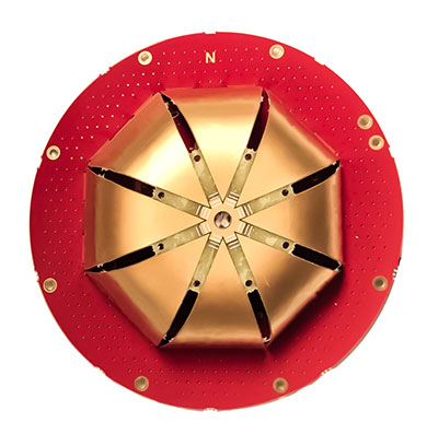
    Tallysman Wireless Inc. has added four new embedded VeroStar Mini products to its line of antennas. The ultra-compact and lightweight embedded VeroStar Mini models offer the same key features as the full-size VeroStar models but in a smaller, lighter package, with either a 90-mm (58 g) or 106-mm (69 g) integrated ground plane, both 32.4 mm in height.

    Innovation: Design and performance of a novel GNSS antenna for rover applications

    The VSM6028, VSM6028L, VSM6328 and VSM6328L embedded VeroStar Mini antennas are designed and crafted for high-accuracy positioning. With an exceptionally low roll-off from zenith to the horizon, VeroStar antennas provide the excellent tracking of GNSS and L-band correction signals at low elevation angles.

    The VSM6028 VeroStar antenna. (Photo: Tallysman Wireless)
    The VSM6028 VeroStar antenna. (Photo: Tallysman Wireless)

    Also, the optimized axial ratio at all elevation angles results in excellent multipath rejection, enabling accurate and precise code and phase tracking. Additionally, VeroStar antennas feature a robust pre-filter and high-IP3 LNA architecture, minimizing de-sensing from high-level out-of-band signals, including 700 MHz LTE, while still providing a noise figure of only 1.8 dB.

    The light and compact wide-band spherical antenna element enables the VeroStar Mini to deliver a ±2 mm phase center variation (PCV), making it suitable for high-precision applications such as autonomous vehicle navigation (land, sea, and air), smart survey devices, and maritime positioning.

    The VSM6028 supports the full GNSS spectrum (the VSM6028L includes support for L-band correction services), while the VSM6328 supports the GPS/QZSS-L1/L2/L5, GLONASS-G1/G2/G3, Galileo-E1/E5a/E5b, BeiDou-B1/B2/B2a, and NavIC-L5 signals and frequency bands (the VSM6328L includes support for L-band correction services).

    The unique features of the VeroStar Mini antennas guarantee it can deliver a high signal-to-noise ratio (SNR), high accuracy, and high precision in the most challenging environments.

  • Rohde & Schwarz provides testing for 5G LBS

    Rohde & Schwarz provides testing for 5G LBS

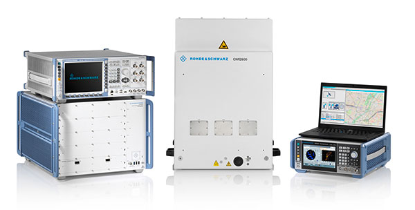
    Rohde & Schwarz supports 5G LBS with assisted GPS and 5G NR FR2 mmW performance testing

    Photo: Rohde & Schwarz
    Photo: Rohde & Schwarz

    Simulator and test company Rohde & Schwarz has verified assisted GPS (AGPS) performance in a commercial mobile device, while simultaneously transferring data using 5G millimeter wave (mmW). This capability is now available with the Rohde & Schwarz TS-LBS (location-based services) test system.

    As wireless network operators roll out 5G NR in the millimeter wave spectrum, it is critical to ensure continued reliability of E911 calls and accurate determination of location in mobile devices.

    5G NR utilizes frequencies in the FR1 frequency range (<7.125GHz) and in the FR2 mmW frequency range (>24GHz). FR2 creates unique challenges for mobile devices in terms of power consumption and heat. With FR2 becoming more common in North American mobile devices, performance of critical services such as E911 emergency calls cannot be allowed to degrade when utilizing this mmW spectrum.

    When used together in the TS-LBS test system, the R&S CMX500 radio communication tester and R&S CMW500 wideband radio communication tester provide a seamless and comprehensive test platform capable of testing LTE, 5G NR FR1 and FR2, while the R&S SMBV100B vector signal generator simulates the GPS L1 & L5, GALILEO, GLONASS & BEIDOU satellite constellations for A-GNSS.

    Other positioning technologies that use barometric pressure sensors, Wi-Fi and/or Bluetooth are also available in the same solution. Legacy technologies such as GSM, WCDMA and LTE are all supported using the same hardware.

    “The addition of FR2 mmW to our TS-LBS test solution gives customers the latest capabilities needed to continue certifying their mobile devices to evolving 5G standards,” said Bryan Helmick, Rohde & Schwarz. “Customers can easily add 5G to existing LTE TS-LBS systems with the simple addition of an R&S CMX500. FR2 support only requires some hardware on the R&S CMX500 and an R&S CMQ500 mmW shield cube.”

    5G NR in the sub 6 GHz frequency range (FR1) can be seen as a natural evolution of LTE to achieve higher bandwidth and more flexibility on the physical layer in order to realize all the new and additional use cases defined for a next-generation mobile network.

    The real technical challenge, however, comes with 5G mmWave (FR2), which opens up a new level of complexity in device development. mmWave frequencies imply measurement challenges that call for new testing approaches.

  • China expanding Loran as GNSS backup

    China expanding Loran as GNSS backup

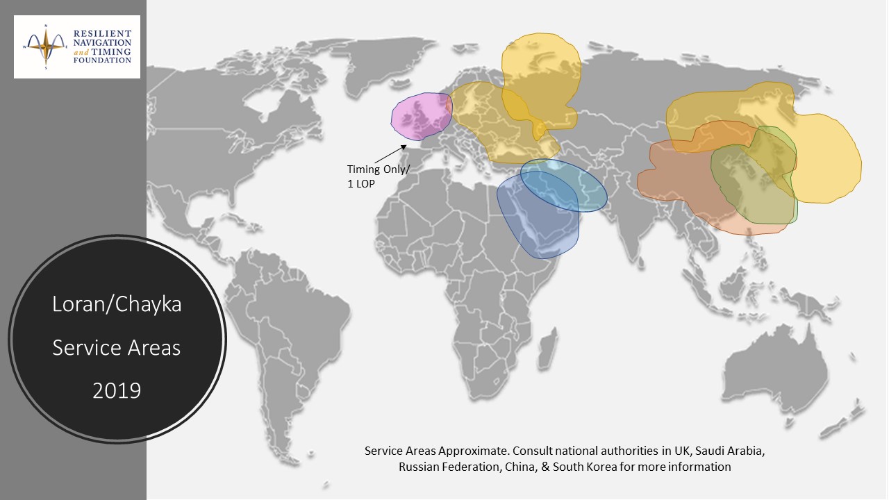
    An August 2020 paper published by the journal Sensors revealed China’s plans to expand coverage of its terrestrial Loran positioning, navigation and timing (PNT) system with three new transmitter sites in the western part of the country. The article indicates that this is a part of providing a backup system for GNSS.

    According to the paper, “…the vulnerability of GNSS to unintentional and intentional interference signals can be found frequently nowadays. For national security and economic effectiveness, a reliable and complementary navigation system is needed desperately. The suitability of the Loran for a backup navigation system has been evaluated and reported.”

    China has operated a Loran system for decades. While the system is capable of operating independently, its signals are also compatible with systems operated by South Korea and Russia. These are coordinated through the Far East Radio Navigation Service (FERNS) to ensure the systems are complementary and reinforce each other where coverage overlaps. The United States and Japan were also members of FERNS until they terminated Loran transmissions in 2010 and 2015, respectively.

    Image: RNT Foundation
    Image: RNT Foundation

    Little public information about China’s Loran system has been available and our queries have gone unanswered. One of the few documents available in the west is a 2014 paper about Loran-C from the Chinese Academy of Sciences in Shaanxi, China which can be accessed through the RNT Foundation website. It shows substantial Loran coverage in the eastern part of the nation, but only a broken circle indicating “projected coverage” in the west.

    Graphic from 2014 Chinese Academy of Sciences paper on Loran showing projected coverage in the western part of the country with a dotted circle. (Image: RNT Foundation)
    Graphic from 2014 Chinese Academy of Sciences paper on Loran showing projected coverage in the western part of the country with a dotted circle. (Image: RNT Foundation)

    The single transmitter in that area projected by the 2014 paper could provide a strong, difficult to disrupt timing signal for fixed receivers with known locations.

    Three new transmitters will be installed according to the August 2020 paper titled “High-Accuracy Positioning Based on Pseudo-Ranges: Integrated Difference and Performance Analysis of the Loran System.” The increased service in the western part of the country will provide “full coverage” positioning, navigation and timing usable by both fixed and mobile receivers.
    The August 2020 paper is the first known documentation in over a decade of specific Chinese intentions regarding its Loran system.

    Still, it is not a surprise to many observers. At 2019’s Stanford PNT Symposium, Xiaochun Lu of China’s National Time Service Center described the nation’s plan for a “comprehensive” PNT system. This system will include a wide variety of PNT sources including low earth orbit satellites, inertial systems, local positioning systems, and Loran.

    Like Ms Lu, the authors of the August 2020 paper are employed at China’s National Time Service Center, which is part of the Chinese Academy of Sciences.