Blog

  • GPS III launch aborted with 2 seconds to spare

    GPS III launch aborted with 2 seconds to spare

    UPDATE (Oct. 5): Elon Musk, SpaceX founder and CEO, said a Falcon 9 launch was halted Friday night due to an “unexpected pressure rise in the turbomachinery gas generator,” referring to a part in the rocket’s Merlin engines, reports SpaceflightNow.

    SpaceX has not yet set a new launch date. Another planned launch, for a Starlink satellite, was also aborted.


    UPDATE (Oct. 3): Only two seconds before launch, SpaceX aborted the scheduled launch of the fourth GPS III satellite on Oct. 2. SpaceX has not yet announced a new launch window, or stated the reason for the cancellation.

    One Twitter user responded with video of the launch up to the moment it was cancelled.


    (Oct. 1) The U.S. Space Force’s newest GPS III satellite, Space Vehicle 04 (GPS III SV04), rolled out to Cape Canaveral’s Space Launch Complex 40 on Sept. 27. Originally scheduled for launch Sept. 30, then Oct. 1, the satellite is now slated to launch 9:43 p.m. EDT on Oct. 2 (01:43 a.m. UTC on Oct. 3).

    The launch was delayed because of a “traffic jam” at the launchpad. According to Spaceflight Now, SpaceX initially rescheduled the GPS launch for Wednesday night after a Delta 4 launch was delayed to Tuesday. After the Delta 4-Heavy’s scrub Tuesday, SpaceX announced the GPS launch would be pushed back to Friday, when there is a 15-minute launch window available opening at 9:43 p.m. EDT (0143 GMT Saturday, Oct. 3).

    The Lockheed Martin-built GPS III SV04 is scheduled to launch aboard a SpaceX Falcon 9 rocket — the third National Security Space Launch (NSSL) mission on a Falcon 9 rocket, the second U.S. Space Force (USSF) first-stage booster recovery, and the sixth USSF launch on Sept. 30. The 15-minute launch window opens at 9:51 p.m. EDT. A live feed will begin 20 minutes before the launch and conclude approximately 45 minutes afterward. A simulcast of the broadcast can be viewed at www.spacex.com.

    “The GPS III program office in partnership with our contract teammates continue to push the envelope on the capabilities they deliver to users, both civil and military around the globe. Our latest GPS III satellites’ nearly 70 percent digital payload provides the U. S. Space Force with greater operational flexibility and cutting edge capabilities while continuing to support legacy users,” said Cordell DeLaPena, Air Force program executive officer for SMC’s Space Production Corps.

    GPS III SV04 will be launched to augment the current GPS constellation comprised of 31 operational spacecraft. GPS satellites operate in Medium Earth Orbit (MEO) at an altitude of approximately 20,200 km (12,550 miles) in six orbital planes. Each satellite circles the earth twice per day. GPS is the premier space-based provider of positioning, navigation, and timing services for more than four billion users worldwide. This latest generation of GPS satellite boasts a 15-year design life — 25 percent longer than the previous generation of GPS satellites on orbit.

    GPS III brings new capabilities to users such as the new L1C civilian signal, which opens the window for future interoperability with international satellite navigation systems.

    “Our GPS III team is excited to be here once again. Less than 3 months ago, we successfully launched GPS III SV03. Since then, the team has successfully delivered the satellite to its final orbit, performed on-orbit testing and delivered the satellite to operations, while executing a mature satellite production line. I can’t be more proud of everyone involved in this mission,” said Col. Edward Byrne, Medium Earth Orbit Space Systems Division chief. “The launch of GPS III SV04 will continue to modernize our GPS constellation by increasing our capabilities with advanced features for both our civil and military users across the world.”
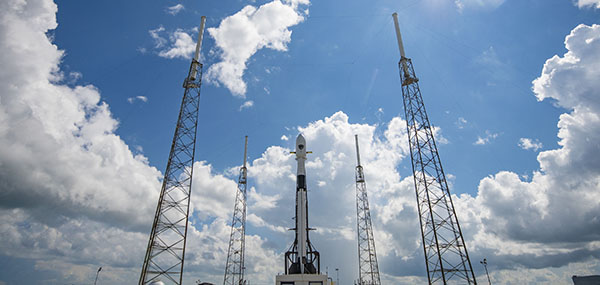
    A Falcon 9 with GPS III SV 04 encapsulated inside the payload fairing the stands vertical on the pad at Cape Canaveral’s Space Launch Complex 40 in preparation for launch. (Photo: USAF/SpaceX)
    A Falcon 9 with GPS III SV 04 encapsulated inside the payload fairing the stands vertical on the pad at Cape Canaveral’s Space Launch Complex 40 in preparation for launch. (Photo: USAF/SpaceX)
  • COVID-19 contact tracing discussed in CGSIC meeting

    COVID-19 contact tracing discussed in CGSIC meeting

    News from NAVCEN

    CGSIC logo

    The 60th meeting of the U.S. Civil GPS Service Interface Committee was held Sept. 21-22, utilizing a virtual meeting platform. This was an opportunity for anyone in the world with access to a computer to attend these public meetings of the U.S. Civil GPS Program.

    For readers who were unable to attend, a synopsis of the meeting is provided below. The full agenda and presentations are available for download from the GPS.gov website.

    The meeting of the CGSIC is an annual event, free and open to the public, conducted to provide updates from U.S. GPS program officials and ensure effective information exchange between the U.S. government and civil GPS users. The two-day meeting is hosted by the U.S. Department of Transportation (DOT) and the Coast Guard Navigation Center (NAVCEN). DOT serves as the civil lead for GPS and chairs the CGSIC in this capacity. NAVCEN is assigned duties as Deputy Chair and Executive Secretariat for the CGSIC.

    Subcommittees of the CGSIC for Timing, International Information, and Surveying-Mapping-Geosciences held meetings on Sept. 21, and a summary of these meetings was presented during the CGSIC plenary session conducted on September 22nd.

    Major General John E. Shaw, Combined Force Space Component Commander, U.S. Space Command, and Commander, Space Operations Command, U.S. Space Force, provided the keynote for this year’s plenary session. This address was followed by comments from Colonel Curtis Hernandez, Director of National Security Space Policy on the National Space Council and briefings from a variety of other government agencies.

    This year’s meeting was replete with briefings from all over the world including an explanation in the International Information Subcommittee of COVID-19 Tracking in South Korea from the Deputy Director of the Korea Ministry of the Interior and Safety.

    Everett Hinkley from the U.S. National Forest Service spoke in the Surveying, Mapping and Geosciences Subcommittee showing how the National Remote Sensing Program supports a variety of business areas of the Forest Service including how they are tracking the spread of the Mountain Pine Beetle infestation in our nation’s forests.

    The Timing Subcommittee provided an engaging presentation on the current and future plans of the National Institute of Standards and Technology’s new Network Time Services.

    Presentations during the plenary session focused on the operational status of the GPS constellation and ground control system modernization, U.S. Space-Based PNT policy, GPS augmentation systems, U.S. engagement with other international GNSS providers, PNT resiliency efforts, as well as a variety of topics related to the status and progress of ongoing GPS programs in the U.S. government.

    If you have suggestions for topics to include in upcoming CGSIC meetings, would like to present a topic, or if you found information from past meetings useful and would like to hear more, please contact us via our Navigation Center “contact us” form. Please be sure to select “Civil GPS Service Interface Committee (CGSIC)” from the pull-down menu.

    From a GPS operational perspective, civilian non-aviation users can submit GPS-related inquiries or report signal interference or degradation to the U.S. Coast Guard Navigation Center online or to the 24-hour watch desk at 703-313-5900.

    Civil aviation users within the United States should contact the Federal Aviation Administration for GPS user support. The GPS Operations Center at Schriever Air Force Base, Colorado, is the Department of Defense lead for operational issues and questions from military users of GPS.

    Rick Hamilton
    CGSIC Executive Secretariat
    GPS Information Analysis Team Lead
    U.S. Coast Guard Navigation Center

  • Thank you for registering.

    Thank you for registering for the upcoming webinar, “The Need for Resilient PNT Services to Ensure Safe and Secure Transportation Infrastructure” sponsored by Microchip.

    A link to the live event will be sent to you two hours before the event. Your personalized event URL will be automatically generated by the ON24 system. To ensure receipt of the email, please whitelist this email address by adding it to your contacts: [email protected].

    This presentation will begin at 1 p.m. Eastern / 10 a.m. Pacific on Thursday, October 22. A recording will also be sent to you the following day so you can watch it on-demand.

    Audience members may arrive 15 minutes prior to live time. If you have any questions, please contact event producer Kelly Limpert at [email protected] 

  • Four decades of leadership

    Four decades of leadership

    Headshot: Miguel Amor
    Miguel Amor, chief marketing officer, Hexagon’s Autonomy & Positioning Division

    GPS World celebrates its 30th anniversary, and together we’ve seen huge leaps of innovation over the years. Reflecting on these developments, I wanted to share some of the contributions Hexagon | NovAtel made to support the evolution of the GNSS industry.

    We began in 1978 in Alberta, Canada, in the telecommunications industry. In the 1990s, we shifted our focus to satellite receivers, choosing to forge ahead in GPS/GNSS technology. This decision would see NovAtel become one of the world’s leading manufacturers of high-precision GNSS components and systems developing multiple new patents and innovative solutions.

    Our engineers have seen first-hand the growth of GPS and other satellite positioning systems worldwide, GNSS adoption across industries from aerospace to agriculture, and the present-day developments of precise positioning in autonomous applications. A rising tide raises all boats, and we helped foster the evolution of the industry through our goals of assured autonomy and positioning.

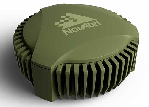
    GAJT-710ML anti-jam antenna. (Photo: Hexagon)
    GAJT-710ML anti-jam antenna. (Photo: Hexagon)

    Assured positioning means a reliable and robust solution you can trust. Technologies we’ve contributed to the broader industry include our GPS Anti-Jam Technology (GAJT) protecting users’ positioning, time and navigation, and SPAN technology, which expertly combines GNSS and inertial navigation systems (INS) measurements for seamless motion observations and a robust positioning solution. The capabilities of these technologies have been major contributors to the evolution of the GNSS industry.

    Hexagon acquired NovAtel in 2007, and we’ve continued to grow and develop exciting new opportunities around the world where GNSS can grow, strengthen and improve applications in agriculture, automotive, defense, marine and many other industries. Our mission of assured autonomy and positioning encourages us to continue providing assured positioning in the most demanding environments and begin bringing autonomy to these markets.

    GPS World has been a key player in covering these technological advancements for the past three decades. Together as an industry, we’ll continue innovating positioning and autonomy, and I’m excited to see how the industry will evolve over the next 30 years.

  • Orolia presents software-defined GNSS simulator with MNSA

    Orolia presents software-defined GNSS simulator with MNSA

    Photo: Orolia
    Photo: Orolia

    Orolia Defense & Security has been granted security approval by SMC Production Corps. for BroadSim MNSA (modernized Navstar security algorithm).

    The company delivered its first batch of MNSA M-Code to multiple customers in late August. BroadSim MNSA joins P(Y)-Code and AES M-Code as another GPS encrypted signal that Orolia Defense & Security supports, the company said.

    Thought, skill, and patience went into developing this solution,” said Tyler Hohman, director of products at Orolia. “Not only have we taken an innovative approach to ensuring the security of this technology, our implementation was designed with ease of use being top-of-mind — from procurement, to delivery, to installation, to testing — so our customers can spend more time supporting their mission and less time making their simulator work.”

    According to Orolia, BroadSim is a proven and trusted solution among government, Department of Defense and military customers with more than 100 systems fielded. BroadSim was recently selected by the U.S. military to support diverse testing of military GPS receivers, the company added.

    BroadSim MNSA users receive a step-by-step guide allowing them to effortlessly set-up and generate MNSA in minutes and quickly downgrade the system on a moment’s notice, Orolia said.

    The capability is currently available as a software upgrade to current BroadSim users or as a purchase alongside Orolia’s BroadSim hardware platform.

    Orolia Defense & Security, which operates as a proxy-regulated company and wholly-owned subsidiary of Orolia, provides resilient PNT solutions to U.S. government agencies, defense organizations and their contractors.

  • GPS Innovation Alliance refutes 5G claims in regard to Ligado

    GPS Innovation Alliance refutes 5G claims in regard to Ligado

    Image: A-Digit/DigitalVision Vectors/Getty Images
    Image: A-Digit/DigitalVision Vectors/Getty Images

    The GPS Innovation Alliance filed an ex parte with the Federal Communications Commission (FCC) regarding its Ligado decision. This follows a letter the alliance sent to FCC Commissioner Michael O’Rielly on July 30 regarding Ligado Networks.

    The document covers a number of details regarding the Ligado Networks and the advancement of 5G.

    According to the document, former NASA Administrator Daniel Goldin claims that FCC’s approval of the proposal by Ligado Networks to repurpose satellite spectrum in the L-Band for high-power terrestrial use should be upheld because it will help advance American leadership in 5G technologies.

    “Winning the race to 5G — against China and other countries — is important, but Ligado’s proposed network is largely irrelevant to 5G,” the GPS Innovation Alliance said in response. “The availability of Ligado’s spectrum for terrestrial use will not contribute to the advancement of 5G but will instead undermine U.S. Global Positioning System receivers and devices that are foundational to wireless technology in general, including 5G.”

    In addition, the GPS Innovation Alliance’s stated in its ex party that the use of L-Band spectrum is not critical for 5G services.

    Other points mentioned in the document include that Ligado’s spectrum is not internationally harmonized, significantly diminishing its effectiveness as a 5G band, and that Ligado’s proposed network simply will not offer a 5G service. According to the GPS Innovation Alliance, Ligado merely proposes to offer limited internet of things services, primarily delivered over custom private networks to specific geographic areas for limited vehicular and utility operations. Not only is this not a 5G service offering, but similar services are already being provided by wireless service providers, the alliance added.

    Read the full document here.

  • SSTL demonstrates new GNSS-R capabilities

    The successful demo consolidates concept designs for a proposed land-sensing ESA Scout mission, HydroGNSS

    Surrey Satellite Technology Ltd. (SSTL) has successfully demonstrated GNSS reflectometry (GNSS-R) from its 18-kg DoT-1 satellite. SSTL has pioneered the new field of GNSS-R with successful payloads on board TechDemoSat-1 and the CYGNSS constellation, and is continuing to develop the technology and data analysis in pursuit of this new science.

    SSTL's DoT-1 satellite
    SSTL’s DoT-1 satellite was launched in 2019. (Photo: SSTL)

    The GNSS-R payload onboard the DoT-1 satellite is incorporated within a new small-form-factor Core Avionics module integral to all SSTL’s future satellite platforms. This innovation paves the way for any SSTL satellite that can accommodate a nadir pointing antenna to become part of a GNSS-R small-sat constellation.

    GNSS reflectometry is an Earth-observation technique that uses GNSS signals as L-band radar sources, allowing the satellite to take measurements of ocean wind speeds, polar ice and hydrological land parameters, at a higher spatial resolution and an order of magnitude lower cost than other methods.

    “GNSS-R is a powerful new science that can contribute valuable data to help monitor changes in our global climate, and I am really pleased with the success of our DoT-1 demonstration.,” said Phil Brownnett, managing director of SSTL. “We now have an advanced instrument design and deep expertise in this new field, and I am hopeful that SSTL’s HydroGNSS concept will progress to a full mission to support the global climate-control challenge.”

    HydroGNSS mission

    The GNSS-R technology demonstration from SSTL’s DoT-1 satellite is also an important stepping stone for a proposed European Space Agency (ESA) Scout Mission Concept called HydroGNSS, which comprises two 40-kg satellites that collect data continually in near-polar orbits, taking hydrological measurements over the whole globe.

    The HydroGNSS mission concept makes advanced use of new GNSS reflectometry techniques such as Galileo signals, dual polarization, and coherent signal acquisition to measure four Essential Climate Variables (ECVs) over land: soil moisture, inundation, permafrost freeze/thaw, and biomass. HydroGNSS has been down-selected by ESA for a concept study; the finally selected Scout mission will commence in 2021.

    The below animated video illustrates the HydroGNSS mission.

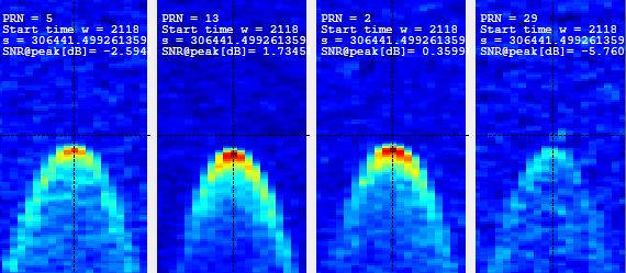
    SSTL’s GNSS-R instrument collects and processes measurements into a “delay Doppler map” (DDM) that can be corrected and inverted into Level 2 products such as ocean wind speed, as has already been successfully demonstrated by the SSTL GNSS-R instruments onboard the TechDemoSat-1 and CYGNSS missions.

    The plot below shows results from data gathered by the DoT-1 satellite on Aug. 12, and shows simultaneous DDMs from four separate GPS satellites. As this is a forward scattering technique, the stronger signals with redder peaks indicate a calmer ocean with lower wind speeds. Approximately 40 minutes of data were collected from the Pacific to the Antarctic to the Southern Ocean.

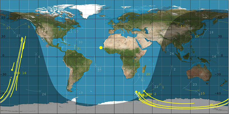
    DoT-1 sub-satellite track (white) and GPS reflection tracks (yellow) collected during 40 minute data operation. (Image: SSTL)
    DoT-1 sub-satellite track (white) and GPS reflection tracks (yellow) collected during 40 minute data operation. (Image: SSTL)
    Four Delay Doppler Maps (DDMs) collected by DoT-1 that show signal reflections from four GPS satellites. (Image: SSTL)
    Four Delay Doppler Maps (DDMs) collected by DoT-1 that show signal reflections from four GPS satellites. (Image: SSTL)

    Soil moisture measurements

    Data from the SSTL GNSS-R instruments onboard the CYGNSS mission have demonstrated the potential for soil moisture measurement by GNSS reflectometry, and preliminary work shows that GNSS-R also has good sensitivity for freeze/thaw sensing in the active zone of permafrost. Unseasonal changes in the permafrost cycles could potentially release larger quantities of methane, which risks exacerbating global climate change.

    GNSS-R can also be used to assess biomass, a measure of forest density which acts as a vital sink for removing carbon dioxide from the atmosphere. In addition to longer term climate observations, soil moisture and inundation measurements from GNSS reflectometry can provide important information for short-term operational purposes, for example, towards Numerical Weather Prediction and flood warnings following rainfall events.

    The development of SSTL’s new GNSS-R instrument was funded in part by the European Space Agency.

  • Agriculture groups join Keep GPS Working Coalition to reverse FCC Ligado decision

    Agriculture groups join Keep GPS Working Coalition to reverse FCC Ligado decision

    Photo: artiemedvedev/iStock / Getty Images Plus/Getty Images
    Photo: artiemedvedev/iStock / Getty Images Plus/Getty Images

    Several agriculture groups have been added to the Keep GPS Working Coalition, which was launched in June to protect GPS users from harmful interference resulting from the Federal Communications Commission’s (FCC) decision to permit Ligado Networks to operate a terrestrial wireless network in the band adjacent to GPS.

    The groups added to the coalition include the Agricultural Retailers Association, American Soybean Association, Equipment Dealers Association, Iowa-Nebraska Equipment Dealers Association, National Corn Growers Association, National Cotton Council of America and USA Rice Federation.

    The new members from the agriculture sector join the Association of Equipment Manufacturers, American Farm Bureau Federation, American Road & Transportation Builders Association, Aircraft Owners & Pilots Association and Boat Owners Association of The United States in urging the reversal of the FCC’s Ligado order.

    “The FCC’s decision represents a sweeping governmental and regulatory assault on farmers who are already facing unprecedented challenges including severe weather, low commodity prices and supply chain vulnerability as a result of COVID-19,” said Dale Leibach, spokesperson for the Keep GPS Working Coalition. “The order must be stopped. The FCC’s decision must be reversed.”

    According to the coalition, farmers are increasingly relying on precision agriculture applications that deliver centimeter-level accuracy that enables farmers to maximize crop yields while lowering costs and environmental impact. Precision farming also reduces costs for consumers, delivers economic benefits for rural economies and enables the efficient production of the foods required to meet a growing global demand for food, fiber and fuel, the coalition added.

    “Ag retailers often fill a role as trusted advisor to their farmer customers, suggesting new and emergent technologies in the precision ag space,” said Daren Coppock, president and CEO of the Agricultural Retailers Association. “Without the GPS location services needed for proper planning and implementation of these resources, farmers may not have the tools they need to increase crop yields, lower input loads and decrease inefficacies. ARA stands behind the coalition’s work to protect GPS as a valuable resource to farmers.”

    Agriculture industry leaders and a member of the House Committee on Agriculture will participate in a conversation discussing how the FCC’s decision to allow Ligado Networks to operate a terrestrial wireless network will threaten the reliability of GPS receivers used in precision agriculture at 11 a.m. EDT on Oct. 1. Details can be found here.

  • GPS and GNSS: confronting dual-use realities

    GPS and GNSS: confronting dual-use realities

    Headshot: Jules McNeff
    Jules McNeff, vice president, strategy & programs, Overlook Systems Technologies

    I welcome the opportunity to contribute and congratulate GPS World on your 30th anniversary. Over those 30 years, I have watched GPS influence how the world works. Early on, along with its vital contributions to U.S. and allied military operations, there was great optimism that sharing civil GPS technology openly would bring improved safety and efficiency to people around the world. However, that sense of optimism has dimmed as GPS, and the GNSS construct and PNT enterprise that it spawned, confront evolving real-world events.

    Several years ago, I wrote a paper positing that in terms of dual-use utility and risks, GPS and related PNT capabilities are analogous to two other technology innovations that have occurred since the Second World War: atomic energy and the internet. The paper considered GPS/PNT in the context of each, reflecting our experiences with those two dual-use extremes.

    The paper concluded that, unlike atomic energy, which has been fairly well controlled, GPS/PNT more closely resembles the internet, which has for better or worse been allowed to grow into a global capability virtually without constraint. For GPS/PNT, a fixation on civil, commercial and scientific uses enabled civil authorities uncomfortable with the military side of the dual-use equation to ignore that reality and focus only on “peaceful” civil and scientific endeavors. Unfortunately, the international comity that participants had hoped for, and that appeared for a time to be real, can no longer be assured.

    Where the U.S. has been open and transparent regarding a dual-use GPS, others have not. Now, the open sharing of information that has been the hallmark of the civil GNSS community over the years must be viewed seriously and candidly through the clear lens afforded by the overt actions of GNSS providers.

    Collective efforts to improve GNSS for peaceful uses ignore the reality that the information shared can equally and dangerously undermine international security. As with the internet, those who have become dependent on precise GPS/PNT services must now reactively create protections and remediations to deal with increasingly real threats from those we had considered colleagues.

    So, naivete and optimism must finally yield in the face of hard reality.

  • China’s BeiDou ushers in a ‘golden decade’ for companies

    China’s BeiDou ushers in a ‘golden decade’ for companies

    Image: Beidou constellation
    Image: BeiDou program

    On Sept. 23, the China BeiDou Application Conference and the Ninth Annual Conference of China Satellite Navigation and Location Services were held in Wuhan, according to a press release from haiwainet (People’s Daily), an official Communist Party newspaper of China.

    Attending the conference were 700 experts, officials and entrepreneurs, as well as company representatives from BDStar Navigation, Amap, Allystar, Unistrong and Wuhan Exsun. “Delegates agreed that China’s BDS PNT (positioning, navigation and timing) industry has just started and is ushering in a golden decade of rapid growth,” the press release stated.

    Zhou Xianwang, mayor of Wuhan, said that Wuhan, an important city for BDS construction and industrial development in China, is accelerating Beidou industry innovation, application promotion and enterprise development with first-class talents and services, and striving to make Wuhan a new highland for Beidou industry innovation and development.

    Yu Xiancheng, president of the GNSS and LBS Association of China, said the Beidou industry in China has reached about $58.8 billion and the industrial ecology has taken shape.

    According to the press release, “China’s Beidou is the first-class Beidou and the world’s Beidou as well. The application and space-time services of Beidou technology will become more popular in China and the world, ushering in a golden decade of development.”

    BDS basic products have been exported to more than 120 countries and regions, and Beidou-based land ownership confirmation, precision agriculture, digital construction and smart ports, etc. have been successfully applied in ASEAN, South Asia, Eastern Europe, West Asia and Africa.

  • New US Army PNT office welcomes industry on GPS-denied solutions

    New US Army PNT office welcomes industry on GPS-denied solutions

    The U.S. Army is opening a new office and laboratory to develop agile position, navigation and timing solutions to reduce soldiers’ dependence on GPS, according to reports in C4ISRNET and Defense News.

    The new PNT modernization product office will focus on developing and deploying solutions that keep soldiers operating in areas where the GPS signal has been denied, degraded or spoofed. The office will open Oct. 8, and will use an open-systems architecture.

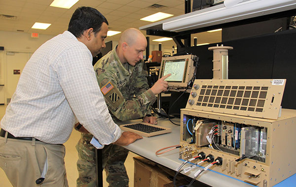
    The new office will also host an Open Innovation Lab, a space where commercial entities can work with the Army to develop PNT solutions. Within lab, the Army has set aside space for the CMOSS (C4ISR/EW Modular Open Suite of Standards) Lab and the Network Cross-Functional Team’s Orion Forge at Aberdeen Proving Ground in Maryland.

    The lab will be physically separated from the more classified areas of the site to encourage engagement with industry. Technologies to be explored include radio frequency systems, GPS, alt-nav, chip-scale atomic clocks, other timing technologies and celestial navigation.

    According to the reports, the technologies will be fielded fast, with new solutions every five years. This is in contrast to the usual method of a decade spent developing technologies meant to last 20 years so that soldiers can always combat adversaries’ capabilities.

    Andradige Silva, electronics engineer for the C5ISR Center's Intelligence and Information Warfare Directorate, and Maj. Doug Williams, assistant product manager for the Joint Battle Command-Platform, access the C4ISR/Electronic Warfare Modular Open Suite of Standards (CMOSS). (Photo: U.S. Army)
    Andradige Silva, electronics engineer for the C5ISR Center’s Intelligence and Information Warfare Directorate, and Maj. Doug Williams, assistant product manager for the Joint Battle Command-Platform, access the C4ISR/Electronic Warfare Modular Open Suite of Standards (CMOSS). (Photo: U.S. Army)
  • Contact tracing applications market set to grow 15% CAGR through 2030

    Contact tracing applications market set to grow 15% CAGR through 2030

    Photo: da-kuk / iStock / Getty Images Plus/Getty Images
    Photo: da-kuk / iStock / Getty Images Plus/Getty Images

    According to a study by Future Market Insights, the contact tracing applications market is set to grow 15% CAGR through 2030.

    “Functional advantages of contact tracing applications include superior data quality, easier tracking and monitoring of larger numbers of people in a time effective manner, the ability of real time analysis, and the significant improvements to management and coordination of manual contact tracing teams,” said a lead analyst at Future Market Insights.

    Key highlights noted in the report include that the market for contact tracking applications is projected to display exponential growth through the forecast period on the back of the ongoing coronavirus crisis; decentralized, Bluetooth-based applications are likely to gain strong traction as a result of data privacy concerns; Android platforms are likely to contribute significantly to adoption owing through higher penetration of associated smartphone models; and Europe is expected to be a prominent market, with East Asia showing lucrative growth prospects on the back of mandatory use in China.

    COVID-19’s impact on the contact tracing applications market

    The COVID-19 pandemic has played a role in the contact tracking application market’s growth: according to the study, the pandemic has been the primary driver for the development, deployment and adoption of contact tracing applications. Government initiatives toward social distancing and patient tracking has influenced the industry’s growth, as well.

    The study also has projected an increase in disease control applications as a result of the COVID-19 pandemic.

    According to the study, countries such as Ireland and South Korea have been able to use contact tracing applications to gain promising results towards breaking chains of coronavirus patients, limiting the risks of community transmission.

    Despite the market’s growth, demand for these applications has been limited to countries with high rates of smartphone penetration. In addition, ethical problems in terms of transparency, privacy and accountability have restrained adoption during this period.

    “However, prospects for contact tracing applications remain positive for the post-pandemic era, owing to potential for use in controlling other infectious disease outbreaks worldwide, albeit at a smaller scale,” the report said.

    This report analyzed various strategies employed by major companies operating in the contact tracing applications market. Some of the participants operating in the contact tracing applications market include IBM, Oracle, Microsoft, Apple, T-Systems, SAP SE, Salesforce.com, Siemens AG and ServiceNow.