Blog

  • Jade Morton honored with ION’s Kepler Award

    Jade Morton honored with ION’s Kepler Award

    The Institute of Navigation’s (ION) Satellite Division presented several annual awards Sept. 25 during the ION GNSS+ Virtual Conference.

    Morton Honored with Kepler Award

    Dr. Y Jade MortonY. Jade Morton received the Johannes Kepler Award for advances in scientific and navigation receiver technology, automated data collection, robust carrier phase tracking, remote sensing, and profound impact as an educator and author.

    Morton is the director of the Colorado Center for Astrodynamics Research at the University of Colorado, Boulder ,where she mentors students, faculty, staff and an ever-expanding international network of collaborators throughout the world. She is a prolific author with more than 270 publications. She was awarded her Ph.D. in Electrical Engineering at Pennsylvania State University. She has also authored articles for GPS World.

    Receiver Technology Pioneer. Morton has made pioneering contributions to the advancement of GNSS receiver technology and utilization of these enhanced capabilities for scientific discovery. Her work brings together scientific rigor with state-of-the-art engineering innovations to simultaneously improve PNT, while revealing remarkable new applications for GNSS.

    Morton’s lab-developed event-driven GNSS data acquisition systems (EDAS), designed to capture severe space weather and ionosphere disturbances of GNSS signals, which could not be handled by existing GNSS monitoring receivers. Her lab designed and built remotely-configurable, multi-GNSS, multi-band, SDR hardware using off-the-shelf components; and developed software including machine-learning algorithms for automatic event detection to trigger raw data recording during these events.

    Network established. Her lab deployed these receivers worldwide. The network has enabled unprecedented studies and forecasting of ionosphere/space weather phenomena, detection of satellite oscillator anomalies, and development of advanced GNSS receivers for navigation and remote sensing under challenging conditions.

    Morton’s group has made groundbreaking advances in GNSS carrier-phase processing and established theoretical performance bounds. Her group developed optimal carrier tracking loop architectures and implementations, and successfully applied the techniques to processing signals experiencing strong ionospheric scintillation for ionosphere and space weather research; radio-occultation signals traversing moist lower troposphere for weather and climate modeling; weak coherent reflected signals from ocean, land, and sea ice for precision altimetry applications; and navigation in urban canyons and on high dynamic platforms.

    Morton is an expert on space weather and ionosphere monitoring. Her research findings range from climatology and morphology of ionospheric plasma irregularities to spatial, temporal and frequency domain characteristics; cause-effect relationships between solar-geomagnetic activities and GNSS signal disturbances; and radio wave propagation theory and simulation. The studies, based on data from her GNSS networks, magnetometers, radar and satellite-based measurements, cover the globe from the arctic to the equator and span an entire solar cycle.

    Volunteer service. Morton has served numerous organizations with thousands of hours of volunteer service including organizing each of the ION’s large technical conferences and leading over 10 student teams participating in ION’s autonomous lawn mower and snowplow competitions, is credited as one of the co-organizing founders of the ION’s Pacific PNT conference, has served as the ION Satellite Division Chair and is the current ION President. Dr. Morton is a past recipient of the IEEE Kershner Award and the ION’s Burka and Thurlow Awards. She is a Fellow of the ION, RIN and the IEEE.

    The Johannes Kepler Award recognizes and honors an individual for sustained and significant contributions to the development of satellite navigation. It is the highest honor bestowed by the ION’s Satellite Division.

    Kimia Shamaei Honored with Parkinson Award

    ION’s Satellite Division presented Kimia Shamaei with its Bradford W. Parkinson Award Sept. 25 for her thesis, “Exploiting Cellular Signals for Navigation: 4G to 5G.”

    The Bradford W. Parkinson Award is awarded annually to an outstanding graduate student in GNSS. The award, which honors Dr. Parkinson for his leadership in establishing both the U.S. Global Positioning System and the Satellite Division of the ION, includes a personalized plaque and a $2,500 honorarium.

    Any ION member who is a graduate student completing a degree program with an emphasis in GNSS technology, applications, or policy is eligible for the award. ION thanks the altruistic experts who served on this year’s selection committee.


  • UK hits reset on how to deliver satnav

    UK hits reset on how to deliver satnav

    The United Kingdom will explore new options for satellite navigation and timing capability to support critical infrastructure, it announced in a press release.

    The Space-Based Positioning Navigation and Timing Programme (SBPP) will explore new and alternative ways to deliver vital satellite navigation services to the U.K. for transport systems, energy networks, mobile communications, and national security and defense.

    The SBPP also aims to boost the British space industry and develop the U.K.’s own capabilities in these services.

    UK GNSS program reinvented

    The new program follows the work of the UK GNSS program, which concludes Sept. 30. UK GNSS began in 2018 as a result of Brexit and the U.K.’s departure from the Galileo program.

    UK GNSS is an exploration programme that has developed outline plans for a conventional satellite system as an alternative to American GPS or the EU’s Galileo. The program will now be reset as the SBPP to build on this work to consider newer, more innovative ideas of delivering global satnav and secure satellite services to meet public, government and industry needs.

    In 2018, the government announced an 18-month program, led by the UK Space Agency, to develop a conventional GNSS, which could meet U.K. security requirements and support the U.K.’s sovereign space and cryptography sectors.

    Work completed by the UK GNSS Programme so far has developed cutting-edge British expertise in areas such as spacecraft and antenna design, satellite and ground control systems, systems engineering and simulation, which have wider applications across the space sector, in addition to supporting specialist U.K. jobs and industrial GNSS capability.

    SBPP program to meet everyday needs

    Image: melis82/iStock / Getty Images Plus/Getty Images
    Image: melis82/iStock / Getty Images Plus/Getty Images

    The refocused SBPP program could include technology that supports people’s everyday lives, such as emergency services to locate incidents, financial services companies to regulate exchanges on the U.K. stock market, or energy networks to ensure households receive power. Satellite navigation systems are also necessary to unlocking future technologies such as driverless cars, smart cities and artificial intelligence.

    Capitalizing on the ingenuity of British businesses and academics, the program will explore the use of different kinds of satellites at various levels of orbit by exploiting technologies offered by companies at the cutting-edge of innovation such as OneWeb, Inmarsat and Airbus.

    A Cabinet Office Study examining the need for a U.K. space-based system for secure positioning, navigation and timing concluded that any solution would need to examine more options and further work is needed to determine what form a potential system takes so it provides value for money.

    To meet U.K. industry and government needs for resilient global navigation and timing while also providing value for money to the public, the new SBPP will consider collaboration with international allies to share satellite navigation services, costs and technology.


    Also see

    With new space program, UK continues march to more holistic PNT


    “Satellites underpin so many of the services that we all use every single day, from precise train timetables on our phones and satnavs in our cars,” said Business Secretary Alok Sharma. “Through our Space-Based Positioning Navigation and Timing Programme, we will draw on the strengths of the U.K.’s already thriving space industry to understand our requirements for a robust and secure satellite navigation system. This includes considering low-orbiting satellites that could deliver considerable benefits to people and businesses right across the U.K., while potentially reducing our dependency on foreign satellite systems.”

    “I am delighted to see a further boost to the U.K.’s already thriving space industry,” said Scotland Office Minister Iain Stewart. “The U.K. government works closely with industry and academia to support the sector. We have high ambitions for the U.K. to be a global sector leader. The U.K. government is expanding its plans to understand requirements for a satellite navigation system. Satellite navigation provides the core services that we all use every day such as our mobile networks and is the key to unlocking further technical innovation in the future. This new programme will potentially pave the way for greater independence from foreign systems such as the United States’ GPS or the EU’s Galileo system which will allow greater opportunities for British businesses.”

    “Our work to date has developed cutting-edge U.K. expertise in satellite navigation spacecraft, antenna design and control systems, while supporting high-skilled jobs,” Graham Turnock, CEO of the UK Space Agency said. “Now is the time to drive this work further to look into wider, more innovative ways of delivering this important national capability — to help protect our critical infrastructure and put the U.K. at the forefront of the development of new space technologies.”

    Currently, the U.K. is entirely dependent on foreign systems for these critical navigation services. SBPP will enable to the U.K. to build on its thriving space industry, home to global players such as Inmarsat, Airbus, Surrey Satellites (SSTL) and others, to become a global leader in space navigation technologies, developing new opportunities for businesses in the U.K. and overseas and creating new highly skilled jobs.

    The government has made clear its ambitions for the U.K. to become a globally competitive space power and is taking action through the newly established National Space Council, emerging National Space Strategy and the Integrated Review of Security, Defence, Development and Foreign Policy, to create the conditions for a strong, secure and innovative space sector that delivers for the British people.

    A government-backed study from London Economics estimated that sustained disruption to existing satellite navigation capabilities would likely cost the U.K. economy £1 billion per day. Investment in space technology and services will enable the U.K. to build back better, unleashing the country’s global competitiveness and underpinning growth and high-skilled jobs.

  • With new space program, UK continues march to more holistic PNT

    With new space program, UK continues march to more holistic PNT

    Photo: UK government
    Photo: U.K. government

    News from the British government appears to be a part of the United Kingdom’s diversification away from primary reliance on GNSS for positioning, navigation and timing (PNT) services, and toward a more diverse set of sources.

    The nation has previously undertaken establishment of a National Timing Centre for distribution of time from suites of atomic clocks and has long transmitted an eLoran timing signal from a government facility in Anthorn.

    Thursday’s press release, titled “Government to explore new ways of delivering ‘sat nav’ for the U.K.,” reinforces the government’s commitment to space-based PNT, but not necessarily from GNSS.

    OneWeb satellites

    The announcement follows significant criticism in Parliament of the nation’s purchase of a 45% share of the bankrupt communications satellite company OneWeb, with the India’s Bharti Holdings having the majority stake. OneWeb had 74 of its planned 648 satellites in orbit when it declared insolvency. With new ownership and financing in place, it plans to resume operations and launch another 36 satellites in December.

    Prime Minister Boris Johnson’s motivation for making the investment was to offset Britain’s post-Brexit exclusion from Europe’s Galileo system. The idea was that OneWeb assets in low earth orbit (LEO) could provide a global British PNT capability.

    This concept faced political and technical opposition from the start. Many technologists in the U.K. and elsewhere doubted that the constellation could be easily adapted to provide sufficiently accurate PNT services. The doubts were so serious that the senior career civil servant responsible for signing the agreement to invest in OneWeb took the very unusual step of refusing to do so without written direction from the political appointee she worked for.

    Before the OneWeb investment, the U.K. government had been studying establish of its own GNSS like America’s GPS and Europe’s Galileo. Sources say the required investment was much higher than the nation wanted to make and would provide little added capability beyond that available from extant systems.

    According to Thursday’s press release, the UK GNSS effort was exploratory and will end this month. It will be “reset” as the Space-Based Positioning Navigation and Timing Programme (SBPP). This project “will explore new and alternative ways that could be used to deliver vital satellite navigation services to the United Kingdom which are critical for the functioning of transport systems, energy networks, mobile communications and national security and defence, whilst boosting the British space industry and developing the U.K.’s own capabilities in these services.”

    While the press release is short on detail, it does mention satellites at low earth orbit and that “a wider range of options” will be examined. This could suggest redoubling efforts on getting PNT from OneWeb, and/or investing in regional PNT satellites.

    Galileo again?

    The press release also says SBPP will “consider collaboration with international allies to share satellite navigation services, costs and technology.” This may signal reengagement with Europe on involvement with Galileo.

    Some observers have said that Brexit did not have to automatically mean that the U.K. was excluded from the Galileo project. European Union membership is not required for participation in the European Space Agency which is responsible for Galileo. Switzerland and Norway, for example, are not EU members, but are members of ESA and sit on its governing board.

    The U.K. government has been very concerned with PNT and GNSS vulnerability since at last 2012 when large solar flares became part of its National Risk Register. In 2017 a London Economics Report found that a five-day GNSS disruption would cost the nation more than $1.3B per day.

    This most recent announcement indicates that Britain is still intent on going its own way and diversifying PNT sources, while still acknowledging the ongoing importance of GNSS and keeping its options open with allies.


    Dana Goward is president of the Resilient Navigation and Timing Foundation. He is the proprietor at Maritime Governance LLC. In August 2013, he retired from the federal Senior Executive Service, having served as the maritime navigation authority for the United States. As director of Marine Transportation Systems for the U.S. Coast Guard, he led 12 different navigation-related business lines budgeted at more than $1.3 billion per year. He has represented the U.S. at IMO, IALA, the UN anti-piracy working group and other international forums. A licensed helicopter and fixed-wing pilot, he has also served as a navigator at sea and is a retired Coast Guard Captain.

  • History of the GNSS industry and milestones ahead

    History of the GNSS industry and milestones ahead

    Headshot: Ellen Hall
    Ellen Hall, president & CEO, Spirent Federal Systems

    The history of GPS is fascinating. In 1957, a study by JHU’s Advanced Physics Laboratory (APL) utilized the Doppler effect to monitor the recently launched Sputnik, allowing researchers to pinpoint the satellite’s position. This endeavor led to the development of the Navy Transit program, the first satellite navigation system, which was successfully testing in 1960. The United States Global Positioning System (GPS) was officially launched in 1973 as a worldwide solution designed to overcome previous limitations. The U.S. Air Force developed the GPS, which designated 24 satellites for full operational capability (FOC) in 1995.

    As a result of a horrific incident in 1983, in which Korean Air Lines Flight 007 wandered into Soviet airspace due to a navigation error and was subsequently shot down by the Soviets, the Reagan administration ordered worldwide access to GPS to ensure a tragedy like this could never happen again. The Clinton administration discontinued Selective Availability to make GPS more responsive and accurate to civil and commercial needs. This led to prolific global use and dependence on GPS for everything from providing data for precision farming applications to the critical timing of financial transactions. This increasing demand for and dependence on GPS has accentuated the importance of securing and safeguarding the system. Vulnerability testing, anti-jamming measures and alternative navigation solutions have become vital in both augmentation and backup for this critical utility.

    As often happens with inventions created through government-sponsored studies, civilian uses become so ubiquitous that the original studies that led to GPS are long forgotten. It is as if GPS has simply always existed. Accordingly, the ground-breaking contributions of certain individuals should be remembered, such as Gladys West for her work in the development of computational techniques necessary for GPS precision. Pioneers such as Roger L. Easton of the Naval Research Lab, Ivan A. Getting of The Aerospace Corporation and Brad Parkinson of APL are credited with inventing GPS and changing, quite literally, how the world works.

    I cannot imagine the world without GPS in some form. The content of what was once only in sci-fi movies is quickly becoming reality with driverless cars, pilotless aircraft and spacecraft. There are no limits on the possibilities in this field. The excitement about the future motivates brilliant minds from classified military installations to the latest civilian laboratories financed by the “Rocket Billionaires,” such as Elon Musk and Steve Bezos.

  • FAA: Access to controlled airspaces advances drone, aviation safety

    FAA: Access to controlled airspaces advances drone, aviation safety

    Photo: RyanKing999/iStock / Getty Images Plus/Getty Images
    Photo: RyanKing999/iStock / Getty Images Plus/Getty Images

    The U.S. Federal Aviation Administration (FAA) has made it easier for drone pilots to quickly and safely access controlled airspace by adding 133 air traffic facilities to the Low Altitude Authorization and Notification Capability (LAANC) system. The expansion is based on feedback from the drone community.

    LAANC is an automated application and approval system for drone pilots requesting to fly below 400 feet in controlled airspace.

    As the FAA continues to modernize the national airspace to accommodate more users, the agency made LAANC accessible for 726 airports and 537 facilities, covering 81% of eligible airspace.

    LAANC is a collaboration between the FAA and the unmanned aircraft systems (UAS) industry which directly supports the safe integration of drones into the nation’s airspace. The service is accessible to all pilots who operate under the FAA’s small drone rule.

  • GNSS reflectometry measurements improved with COVID-19 pandemic

    GNSS reflectometry measurements improved with COVID-19 pandemic

    Parked cars near ground station decreased accuracy from 2 to 4 centimeters

    A new study shows that the quality of GNSS reflectometry measurements may have improved significantly during the pandemic because of the lack of cars parked near the ground station, according to Science Daily. GNSS reflectometry is used for earthquake early warning systems, determining flood risks, and many other geodesy applications.

    The study, carried out by geodesists from the University of Bonn, investigated the location of a precise GNSS antenna in Boston, Massachusetts.

    GNSS reflectometry works well if the surrounding ground is flat, like the surface of a mirror, study author Jürgen Kusche explained to Science Daily. “But many GNSS receivers are mounted on buildings in cities or in industrial zones. They are often surrounded by large parking lots — as is the case with the antenna we investigated in Boston.”

    The researchers show that parked cars significantly reduced the quality of the elevation data by scattering the GNSS signals, causing them to be reflected several times before they reached the antenna, like a cracked mirror. This reduces signal intensity and provides “noisy” data — hard to correct with pattern recognition because the parked cars change positions every day.

    “Before the pandemic, measurements of antenna height had an average accuracy of about 4 centimeters due to the higher level of noise,” Makan Karegar told Science Daily. “During the lockdown, however, there were almost no vehicles parked in the vicinity of the antenna; this improved the accuracy to about 2 centimeters.”

    While GNSS stations were historically installed in sparsely populated regions, recent installations have been in urban areas to support engineering and surveying work.

    “Our study recommends that we should try to avoid installation of GNSS sensors next to parking lots,” Karegar said.

    Citation. Makan A. Karegar, Jürgen Kusche. Imprints of COVID‐19 lockdown on GNSS observations: An initial demonstration using GNSS interferometric reflectometry. Geophysical Research Letters, 2020; DOI: 10.1029/2020GL089647


    Feature photo: welcomia/ iStock / Getty Images Plus / Getty Images

  • Inertial Labs releases INS-DU GPS-aided unit for high-accuracy positioning

    Inertial Labs releases INS-DU GPS-aided unit for high-accuracy positioning

    The new INS-DU delivers high-accuracy RTK positioning for air, land and marine applications

    Photo: Inertial Labs
    Photo: Inertial Labs

    Inertial Labs has released a new GPS-aided inertial navigation system (INS). The INS-DU is a high-performance strapdown system that determines position, velocity and absolute orientation to any platform it is mounted to.

    The INS-DU has a dual-antenna u-blox GNSS receiver that provides 1-cm real-time kinematic (RTK) position from RTCM 3 RTK corrections and supports a wide range of GNSS constellations.

    Designed for UAVs, land vehicles and marine vessels, the INS-DU is an effective, low-cost solution that uses a range of aiding data for different applications. With highly accurate navigation in GNSS-denied environments, the INS-DU delivers a cost-effective GNSS-denied solution, according to Inertial Labs.

    One of the key elements to the success of the INS-DU is its use of the miniAHRS, which utilizes 3-axes each of precision magnetometers, accelerometers and gyroscopes to provide orientation of the device under measure. It contains cutting-edge algorithms for the motion of robots, unmanned and autonomous vehicles, and antennas.

    MiniAHRS mini fluxgate magnetometers have an advantage over commonly used magneto-inductive or magneto-resistive alternatives and have been a trusted North reference for more than 70 years.

    The INS-DU provides a full navigation solution for both GNSS and GNSS-denied environments. With custom interfaces and a power consumption of two and a half of a Watts, the INS-DU is a versatile solution fit for a wide variety of users with power consumption restrictions.

    In addition, the INS-DU contains our on-board sensor-fusion filter, state-of-the-art navigation, and guidance algorithms and calibration software.

  • Bynav introduces C1 GNSS receiver for GNSS mass market

    Bynav introduces C1 GNSS receiver for GNSS mass market

    Photo: Bynav
    Photo: Bynav

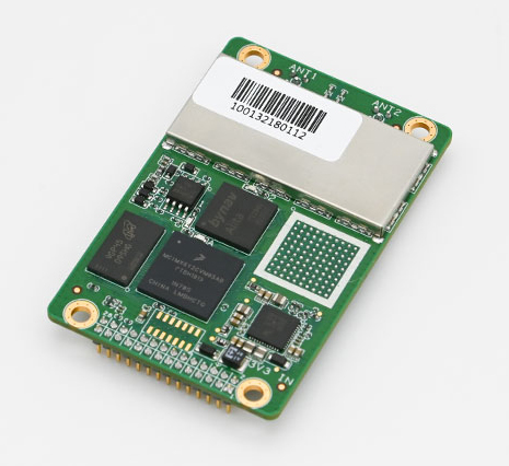
    Bynav Technology Co. Ltd. has released the C1 GNSS RTK OEM receiver and the A1 industrial-grade IMU-enhanced GNSS OEM receiver based on Bynav GNSS baseband ASIC Alita and RFIC Ripley. Bynav supplies GNSS high-precision receivers to the Chinese vehicle driver-testing market.

    The C1 GNSS RTK OEM receiver board measures 46 × 71 mm and supports dual-antenna heading and full-constellation, including GPS, BDS, Galileo, GLONASS, QZSS, NavIC and SBAS, as well as providing enhanced interfaces like UART serial port, Ethernet, 3 EVENT_IN, 3 EVENT_OUT, 1PPS and CAN bus for easy integration with an external inertial measurement unit (IMU), odometry, lidar or visual SLAM.

    The A1 GNSS/INS OEM receiver, measuring 46 × 71 mm and weighing 25 g, is integrated with an industrial-grade IMU (gyro 2.7deg/hr) with an embedded, deeply coupled GNSS+INS algorithm engine as well as tilt measurement algorithm to provide stable, high-precision position and attitude even in the event of GNSS outages.

    Most of the vehicle driver testing centers in China have automated their exams with the assistance of GNSS high-precision positioning. As a strategic partner of Duolun Technology, China’s driver-testing system integrator, thousands of drivers testing vehicles equipped with Bynav GNSS RTK receivers are moving around China every day.

    The R&D team of Bynav has taken part in the construction of China BeiDou Satellite Navigation System since 2002. With a powerful and experienced GNSS experts’ team and large-scale scenario verification on dynamic driver-testing vehicles, Bynav has successfully developed the high-precision GNSS baseband ASIC Alita and the RFIC Ripley which have been now integrated in the A1 and C1 products.

    The performance of the A1 and C1 have been verified and recognized by many domestic customers in the field of vehicle driver testing and autonomous driving.

    “We are committed to developing intelligent driving vehicles and commercializing them as soon as possible, in which the GNSS/INS receiver plays an important role to provide absolute position,” said Ying Long, deputy general manager of the Changsha Intelligent Driving Institute, a well-known autonomous driving company in China. “That’s why I started work together with Bynav for a cost-effective and high-performance positioning solution. Currently, the Bynav’s GNSS/INS receivers have been used in our unmanned sweepers, self-driving trucks and other products, and it comes out that the A1 performance is comparable to the world-class and high-end products we used.”

    Both receivers support dual-antenna heading and full-constellation and full-frequency tracking (including BDS-3 and L5), and provide SD card interface for raw data storage.

    Both C1 and A1 are now available for direct purchase. For wholesale price, contact [email protected].

  • Europe issues tender for GNSS high-accuracy evolution

    Europe issues tender for GNSS high-accuracy evolution

    Image: ESA
    Image: ESA

    The European Commission (EC) is seeking help to build a roadmap for high-accuracy Galileo and EGNOS services.

    The EC Directorate-General for Defence Industry and Space (DG-DEFIS) has issued an Invitation to Tender for a service contract to address how the future evolution of European GNSS (EGNSS) could be beneficial for innovative demanding applications.

    The new service contract will assess the feasibility of an integrity service complementing EGNSS high accuracy in the 2030+ timeframe.

    The new service contract will feed into the evolving needs of demanding new applications without disrupting the current business models of established service providers, according to the European GNSS Agency. The tender will assess various steps needed for the Galileo and EGNOS services to evolve.


    A webinar to explain the framework and objectives of the procurement and the different tasks in the procurement is planned on September 23 at 16:00 CEST.


    Emerging and next-generation applications will require more demanding positioning solutions to be able to offer innovative services. The use of an integrity service complementing European GNSS (EGNSS) High Accuracy in the 2030 horizon could result in the provision of an accurate and reliable positioning solution that would translate into the overall improvement of future innovative and demanding services.

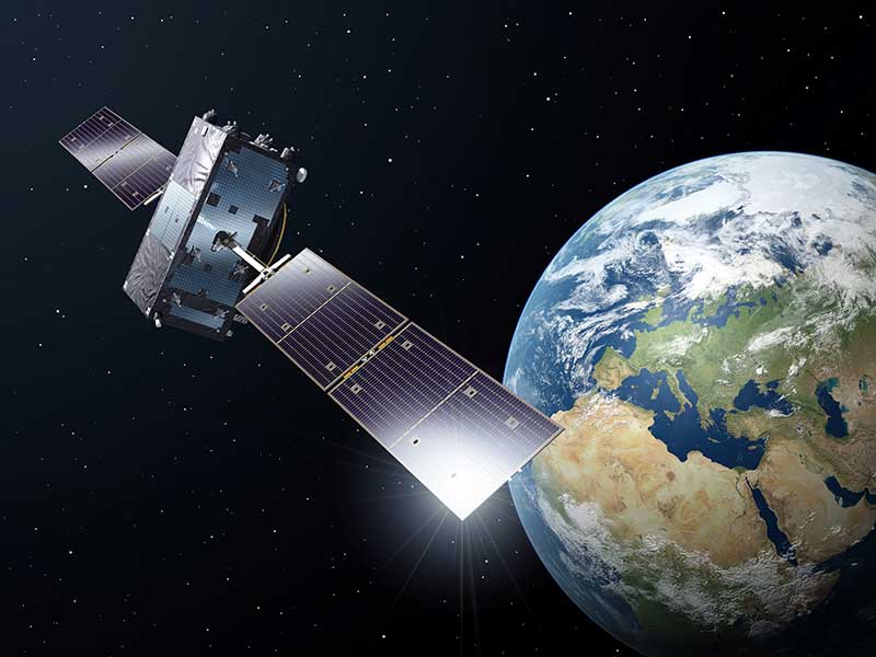
    As part of the services provided by Galileo, the Galileo High-Accuracy Service (HAS) will provide high-accuracy positioning and synchronization information, the EC said.

    EGNOS version 3 will extend the service area to the entire landmasses of EU Member States. New EGNOS services could be implemented in further releases of EGNOS as an option for the integrity service complementing EGNSS High Accuracy.

  • Transiting to GPS and beyond

    Transiting to GPS and beyond

    Headshot: Terry Moore
    Terry Moore, professor emeritus, University of Nottingham

    The end of July was quite a momentous occasion for me as I accepted the offer of voluntary redundancy from the University of Nottingham after almost 35 years of employment. If I then add the six years I spent at Nottingham as an undergraduate and then as a postgraduate student, that totals almost 41 years of my life spent at the university.

    I guess it is not surprising that recently I have spent some time reflecting on those years and the changes that have occurred in positioning and navigation throughout that long period. My first degree was in civil engineering, although I did specialize in land surveying in the final year.

    Professor Ashkenazi. My first contact with satellite navigation was early in 1981, when Professor Vidal Ashkenazi, later my mentor and good friend, brought a JMR-1 Transit Doppler NAVSAT receiver into our second-year surveying lectures. That gentle repetitive beep as the receiver tracked the Transit satellites had me hooked for life. I don’t think I realized then that navigation and positioning would be the focus of my working life, but I was fascinated by the technology and prospects, and it really was one of those life-changing moments.

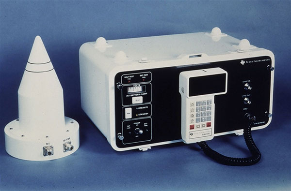
    1984: Texas Instruments TI-4100. (Photo: NOAA National Geodetic Survey)
    1984: Texas Instruments TI-4100. (Photo: NOAA National Geodetic Survey)

    My Ph.D. continued in surveying and geodesy, and the focus was on the precise orbit determination of the LAGEOS geodetic satellite using Satellite Laser Ranging measurements. The goal was to investigate the determination of Earth Rotation Parameters (the Polar Motion and diurnal spin of the Earth) as part of an international collaboration known as Project MERIT.

    Using Transit. I remember taking a Magnavox MX 1502 Transit receiver down to a conference at Herstmonceux Castle, and over the weekend I set up the instrument in my parent’s back garden in Sheffield, much to their amazement.

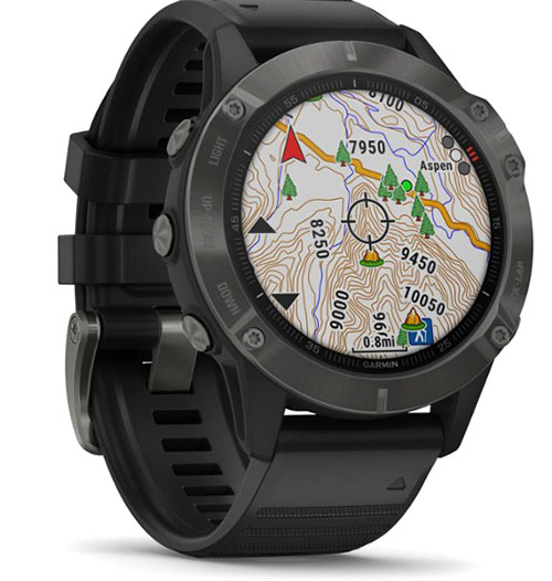
    2020: Garmin Fenix6 smartwatch. (Photo: Garmin)
    2020: Garmin Fenix6 smartwatch. (Photo: Garmin)

    I did not start working on GPS until 1985, through my post-doc research position, sponsored by British Petroleum. This was investigating the first uses of GPS within the oil-and-gas sector for precise offshore positioning on platforms and survey vessels. The early GPS receivers we used were the Texas Instruments TI-4100 receivers, of which we borrowed five for the first long survey campaign to measure precise heights down the East Coast of England and Scotland. What a “pleasure” they were to use. I remember manually typing in the elements of the almanac for the receiver to acquire one satellite at a time.

    Soon after we bought our first two Wild-Magnavox WM-101 receivers, which looked to be masquerading as Samsonite luggage. And now here I sit typing this article with GNSS receivers in the Garmin watch on my wrist and the Samsung phone beside me on the desk.

    Last weekend, I was walking in the Lake District of England with my wife and daughter, and I did a quick count of our GNSS receivers. We had eight GNSS receivers (in watches, phones and handheld receivers) between the three of us, and of course there were others in our cars and the cycling GNSS receivers all nearby. How things have changed and how could we have imagined such as staggering growth in the ubiquity of GPS, and now GNSS, over those past 35 years.

  • Global trends in the mapping industry during the pandemic

    Photo: SimActive
    Photo: SimActive

    By Philippe Simard, Ph.D.
    President, SimActive Inc.

    The COVID-19 pandemic has brought uncertainties to all businesses, and the mapping industry has been no exception.

    Slowdowns were observed during the first few months of 2020 as lockdowns were gradually enforced in Asia, then Europe, and finally the Americas.

    As expected, projects were delayed during that initial period as companies were reorganizing their operations to allow for remote work.

    Once that transition was overcome, a great number of projects resumed, and the geospatial field has been gradually coming back to normal since then. That can be explained by different factors, including, for example, several governments accelerating infrastructure projects to stimulate the economy.

    A lot of mapping firms have turned the pandemic into an opportunity to improve their processes. Slower times allow reviewing production workflows and assessing bottlenecks. Once identified, new hardware and software solutions can be evaluated to optimize production.

    Interestingly, the resulting investments into new solutions has been significant. Companies are seeing a quick payoff as their workload is rapidly accelerating, leading to an increase in their bottom line.

    Overall, the mapping industry was able to rapidly adjust to the new reality caused by the pandemic. The changes that are being made in performing projects not only allow us to minimize risks in the short term, but also to increase profitability in the longer term.


    SimActive is the developer of Correlator3D software, a patented end-to-end photogrammetry solution for the generation of high-quality geospatial data from satellite and aerial imagery, including drones. Correlator3D performs aerial triangulation (AT) and produces dense digital surface models (DSM), digital terrain models (DTM), point clouds, orthomosaics, 3D models and vectorized 3D features.

    Powered by GPU technology and multi-core CPUs, Correlator3D ensures high processing speed to support rapid production of large datasets.

    SimActive has been selling Correlator3D to leading mapping firms and government organizations around the world, offering cutting-edge photogrammetry software backed by exceptional customer support.

  • Comment sought on OGC API standard for geospatial web processing

    Comment sought on OGC API standard for geospatial web processing

    New process simplifies task of computational geospatial processing accessible via web services

    OGC logoThe Open Geospatial Consortium (OGC) seeks public comment on a new draft OGC API standard: OGC API – Processes – Part 1: Core. Comments are due by Oct. 19.

    The draft OGC API – Processes Standard specifies a Web API that enables the execution of computing processes and the retrieval of metadata describing their purpose and functionality. For example, these processes could combine raster, vector, coverage and/or point cloud data with well-defined algorithms to produce new raster, vector, coverage and/or point cloud information.

    The draft OGC API – Processes Standard builds on the Web Processing Service (WPS) 2.0 standard and defines the processing standards to communicate in a RESTful manner using JSON encodings. This API is a newer and more modern way of programming and interacting with resources over the web while allowing better integration into existing software packages.

    In many cases, location data, including data from sensors, must be processed before the information can be effectively used. OGC API – Processes, just like the OGC WPS Interface Standard, provides a standard interface that simplifies the task of making simple or complex computational geospatial processing services accessible via web services.

    Such services include well-known processes found in GIS software as well as specialized processes for 2D/3D/4D modeling and simulation. The API also makes it easy for developers to implement microservices that can handle location data.

    The draft OGC API – Processes Standard provides a similarly robust, interoperable, and versatile protocol for process execution across the Web. OGC API – Processes supports both immediate processing for computational tasks that take little time and asynchronous processing for more complex and time-consuming tasks.

    As with other OGC APIs, OGC API – Processes consists of optional parts that each provide extra functionality. This specification, Part 1: Core, is intended to be a minimal useful API for the execution of processes from the geospatial domain. There are no constraints on the types of processes that can be published through the API. Examples of processes that have been demonstrated during the development of the draft API standard include routing, contour generation, buffering, coverage processing and several others. The API is therefore expected to be applicable to several domains.

    The candidate OGC API – Processes – Part 1: Core standard is available for review and comment on the OGC Portal. Comments are due by October 19, 2020, and should be submitted via the method outlined on the OGC API – Processes – Part 1: Core draft Standard’s public comment request page.