Terrain Painting in Global Mapper v22. (Image: Blue Marble)
Blue Marble Geographics has released version 22 of Global Mapper along with an upgrade to the accompanying Lidar Module.
Global Mapper GIS software provides both novice and experienced geospatial professionals with a comprehensive array of spatial data processing tools, with access to a variety of data formats.
Among other features, Version 22 includes
Eye Dome Lighting settings in the 3D viewer to help improve the visual display of vector and lidar data
a new tool for simplifying meshes or TINs
a new Spatial Operations tool for analyzing the relationship between overlapping vector features
a new option to measure the overlap between two or more lidar, raster/image and terrain layers
a new consolidated Digitizer Menu providing convenient access to all drawing and digitizing tools
The Lidar Module, an optional add-on to Global Mapper, provides advanced point cloud processing tools, including Pixels to Points for photogrammetric point cloud creation using overlapping drone-captured images, automatic and manual point cloud classification, feature extraction, hydro-flattening, and more.
Terrain Paint tool. The upgraded Lidar Module includes a new Terrain Paint tool for manipulating elevation values in a freeform way, a new algorithm to improve building classification results, improved building extraction with better 3D shape simplification for generating building footprints, a new option to create a process summary report when using the Pixels to Points process, dramatically faster rendering of lidar path profiles with a large number of points, and more.
“The version 22 release illustrates Global Mapper’s rapidly expanding geospatial footprint,” stated Blue Marble’s President, Patrick Cunningham. “In this one release cycle, we have introduced countless new tools for GIS analysis.Global Mapper is truly an accessible yet powerful GIS platform. As always, we are pleased to be able to bring all of these capabilities together in one GIS platform while keeping the price affordable.”
Blue Marble Application Specialists will hold a webinar Sept. 30 to showcase Global Mapper v22. This presentation is scheduled to begin at 2:00 pm (U.S. Eastern Time), and it will allow attendees to see the latest tools and ask questions about the new functionality. Registration is required.
London building-design agency DCSK is using 3D building models from Bluesky to inform the design of high-profile urban residential developments.
Derived from the most up-to-date and accurate aerial photography, the Bluesky 3D models allow DCSK to place a design within its real-world context, consider sensitive view and vantage points, and communicate ideas to clients, planning authorities and the public.
DCSK has used a number of models from Bluesky, including a detailed representation of central Birmingham for the design of a 24-storey student accommodation on Lancaster Street.
“We have always had to consider how a design sits within the existing cityscape and how it will interact with the buildings and infrastructure that surround it,” said James Khamsi, Director of DCSK. “Before geographically accurate computer representations, such as the Bluesky 3D models, were available and affordable, we relied on a combination of site photographs and traditional 2D maps. This was a crude workflow that raised potential concerns about the currency and accuracy of information that was informing both the design and resulting planning permissions.”
DCSK is using 3D models from Bluesky for projects such as Curzon Circle Student Accommodation and others.Photogrammetrically derived from stereoscopic aerial photography, the Bluesky models are fully rendered and are provided as either wireframe or block models in a format suitable for use in both CAD and GIS software.
All Bluesky 3D models are supplied with a digital terrain model (DTM) depicting the topography of the underlying surface.
DCSK imports the Bluesky data into its 3D modelling software Rhino, where it is used to create a background layer for the design. The development site is isolated, and this data removed from the background layer, allowing for the detailed design to be dropped in. The proposed development can then be viewed and analyzed in its real-world context with detailed assessments of access ways and viewpoints, for example.
“The Bluesky models allow us to inhabit the site and experience the design as if we were there,” said Khamsi. “We can explore potential sensitivities, and, as the models are agile, we can massage the design exploring different options without leaving the office. The Bluesky models are also intuitive and therefore easy to interpret allowing us to communicate complex design ideas.”
Mobile GIS Services (MGISS) has been awarded a place on the United Kingdom government’s procurement platform G-Cloud.
Designed to ease the procurement of cloud services by the public sector, the G-Cloud 12 framework makes it easier for customers to find, review and contract MGISS’s advanced geospatial software services through an online digital marketplace. Managed by Crown Commercial Services, it is forecast that successful suppliers, such as MGISS, will receive up to £2 billion in business.
In a parallel achievement, MGISS has also been accredited as a supplier of software, hardware and support services to the utility sector by the supplier assurance company Achilles.
A specialist in mapping and geographic information technology, MGISS also is working alongside organizations such as United Utilities and Northumbrian Water Group and it is hoped that successful qualification under the Achilles UVDB pre-qualification system will help MGISS gain further traction within this sector.
MGISS has also attained the Workplace Wellbeing Charter. Recognizing a commitment to improving the lives of its team members, MGISS received accreditation across a number of facets including leadership, health and safety, mental health and absence management.
“Although recognizing completely different aspects of the business these awards are all significant milestones and accomplishments in their own right and the entire team should be proud of the hard work and commitment they have expended to achieve them,” said MGISS Managing Director and Founder Mike Darracott. “The G-Cloud and Achilles accreditation will put MGISS front and center for the leading players within the public and utility sectors and this will help us capitalise on our work to date with organizations such as Surrey County Council and Wales and West Utilities.
“The Workplace Wellbeing Charter not only recognizes our existing commitment to the health and wellbeing of our team it also gives a benchmark to work from and a toolset to work with to continuously improve,” he continued, “and a happier and healthier workforce will, we hope, make the business even better and stronger.”
Firm will provide geophysical surveying services across multiple states
Dewberry, a privately held professional services firm, has been awarded multiple task orders from the U.S. Geological Survey (USGS) under the Geospatial Products and Services Contract (GPSC) to perform airborne geophysical surveys in portions of Missouri, Illinois, Kentucky, Texas and New Mexico for the USGS Earth Mapping Resources Initiative (Earth MRI).
“Earth MRI is a play on words, as people are familiar with the use of magnetic resonance imaging (MRI) to image inside the human brain,” said Dewberry Project Manager David Maune. “Dewberry is excited to support USGS in its mission to assess critical minerals using airborne geophysical survey technology.”
Dewberry will perform very low-altitude magnetic and radiometric surveys from a fixed-wing aircraft and a helicopter with towed-array sensors to image subsurface geologic structures in search of undiscovered critical minerals and rare earth elements vital for the electronics industry.
These projects, which will be used to evaluate the potential for undiscovered critical mineral deposits contributing to an understanding of the major mineral systems for the two regions, are expected to be completed in early 2021.
The Russian Defense Ministry has tested new ammunition for its Tornado-S missile system, which is delivered via the multiple launch rocket system (MLRS), reports Russian newspaper Izvestia. Tornado-S is an ultra-long-range missile with a previous flight.
The new MLRS is equipped with GLONASS signal reception equipment and an automated guidance and fire control system. The operator can enter coordinates into the system and give the command to set the guides and open fire. In addition, the system can itself receive and process information from reconnaissance vehicles and drones. For each missile, both range and azimuth angle can be set. The MLRS can launch 12 missile at once.
Previously, the declared flight range of the Tornado-S missiles was about 120 km. Distance with the new ammunition was not disclosed, but the goal was 200 km. The main feature of the missiles is the ability to turn on the target after launch.
The Russian Army was expected to receive 30+ Tornado MLRS this year.
China will lose access to a strategic space tracking station in Western Australia when its contract expires, a decision that could affect BeiDou constellation service in the Pacific region, according to a Reuters report.
A contract between the Swedish Space Corp. (SSC) and China has given Beijing access to a station antenna since 2011, but the SSC satellite station is primarily used by the United States and its agencies.
The Swedish state-owned company told Reuters it wouldn’t enter into any new contracts at the Australian site to support Chinese customers after its current contract expires, but did not disclose the exact date.
Ground stations are a vital part of space programs given they create a telecommunications link with spacecraft. While stations have different capabilities, they can be equipped to coordinate satellites for civil-military GNSS such as Beidou, Russia’s GLONASS, the European Union’s Galileo system, and U.S.-owned GPS.
China’s space program has been increasing its access to overseas ground stations in recent years in line with the expansion of its space exploration and navigational programs.
“Generally speaking, anywhere you put a GNSS monitoring ground station will improve the accuracy of positioning for that region,” said Joon Wayn Cheong, a senior research associate at the University of New South Wales’ School of Electrical Engineering.
China wants to remove its dependence on GPS as part of broader plans to expand its global influence, says Christopher Newman, professor of Space Law and Policy at Northumbria University in Newcastle, England. “GPS could be made unavailable to them in a military conflict. An independent secure system is crucial for the capabilities of the People’s Liberation Army [China’s military] with respect to targeting, weapons, navigation,” he told Reuters.
Beijing last year reestablished diplomatic ties with the small Pacific island nation of Kiribati, where it has a mothballed ground station.
A link to the live event will be sent to you two hours before the event. Your personalized event URL will be automatically generated by the ON24 system. To ensure receipt of the email, please whitelist this email address by adding it to your contacts: [email protected].
This presentation will begin at 1 p.m. Eastern / 10 a.m. Pacific / 7 p.m. Central European Time on Thursday, October 29th. A recording will also be sent to you the following day so you can watch it on-demand.
Audience members may arrive 15 minutes prior to live time. If you have any questions, please contact event producer Mackenzie Schoenherr at [email protected]
With advantages provided by geographic information systems (GIS), the demand for GIS in the telecom industry has increased in recent years. According to a report published by Allied Market Research, the global telecom market is anticipated to garner $3.27 million by 2023.
GIS has fortified the telecom industry by reducing costs and augmenting capital planning. GIS mapping can improve outage prediction, resource management and infrastructure determination.
GIS also can help the emerging economies for independent energy, efficient infrastructure, and enhanced communication systems. GIS provides imagery, geocoding, modeling, routing and the required data for these applications.
GIS is rising in popularity as it eases access to critical sources of business intelligence.
Impacts in the telecom industry
GIS mapping supports telecom companies with factors such as enhanced customer service with location data and imagery, efficient resource dispatch, and prompt sharing of location data. This enables telecom industries to track locations and have a better understanding of service layout.
GIS mapping lets companies know the geospatial relationships of their facilities, resources and ground features, and provide faster and more effective customer service.
GIS also helps identify faulty circuits. It can help model the solution online and offer best-case scenarios, resulting in improved operations and enhanced customer service.
GIS mapping also helps the sales and service team understand their targets by tracking multiple layers of geospatial data and providing insight into the customer base.
Information on network structure
Almost every telecom company focuses on offering effective, functioning networks, along with network monitoring, testing of network elements, maintenance and customer services. The real-time network structure offered by GIS solutions enhances these monitoring and service activities.
With GIS, networks get instant access to information such as customers’ history and rank, current network structure, signal quality in precise demography, and any need for maintenance or restoration of services. Moreover, GIS makes the services more reliable and fast.
GIS solutions are also beneficial for determining market demand for future estimations. GIS offers a better understanding of the relationship between customers’ topographical presence and companies’ marketing operations. It helps companies identify networking issues and easily reach customers, along with offering information on other issues.
With its precise geography, GIS helps telecom companies meet service demand and develop budgets for promotional activities and marketing campaigns.
Enhancing telecom services
With computers and mobile devices a necessity for most of us, many telecoms want to expand to provide services in rural areas — a major reason for their adoption of GIS.
Another motivator is the surge in demand for augmented reality and virtual reality, part of the increase in the adoption of GIS for mobile and broadband services.
Smart Cities. GIS provides a platform that works with Customer Relationship Management (CRM) systems, networks, databases, fault management system and wireless location. The demand for growth also depends on the rise in demand for satellite images by companies that provide maps and an increase in government spending to develop and build smart cities.
Moreover, the rising use of technology, the internet, and other digital platforms in rural areas has sparked companies to expand their services.
With companies focusing on broad network coverage, greater connectivity and emerging innovations such as 5G, the field of mobile telecommunications technology is anticipating opportunities to expand market growth.
Akshita Pacholi has a master’s degree in English literature and is working as a content writer with Allied Market Research.
GPS technology is doing far more than helping us navigate or receive accurate time. It is now being used to fight the spread of the global COVID-19 pandemic.
Global navigation satellite systems are being used to collect big data on travel and contact, but they are also being used in more unconventional ways: for example, quarantine enforcement and sanitation technology.
Read on to learn about a few recent developments in the world of GNSS/GPS that are bolstering the battle against the novel coronavirus.
Electronic monitoring enforces quarantine
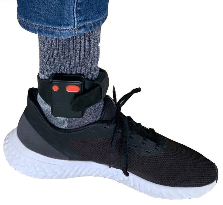
There is a surge of applying ankle monitors to track sick individuals and deter them from spreading the virus further. According to BloombergBusinessweek, one business is thriving because of it: providers of electronic ankle monitors.
Kentucky courts are requiring GPS ankle monitors for people who test positive for COVID-19 and refuse to self-quarantine. Kentucky couple Elizabeth and Isaiah Linscott were two of a growing number of people placed under house arrest after Elizabeth tested positive for COVID-19 and denied signing the Self-isolation and Controlled Movement Agreed Order, a health department document promising she would stay home.
Photo: Regulus Cyber
Elizabeth told Louisville television station WAVE 3 News that she did not sign because she disagreed with the wording of the document. She said that she was concerned about having to contact the health department before traveling, even in the case of an emergency.
“My part was if I have to go to the ER, if I have to go to the hospital, I’m not going to wait to get the approval to go,” she said.
A few days after Elizabeth refused to sign the paperwork, her husband opened their door to an entourage of law enforcement officers serving them with a Health Department order to wear ankle monitors.
“I open up the door, and there’s like eight different people, five different cars, and I’m like ‘what the heck’s going on?’ This guy’s in a suit with a mask. It’s the Health Department guy, and they have three papers for us. For me, her and my daughter,” Isaiah said.
The Linville family is now confined to a 200-foot radius. If they leave their designated quarantine area, their ankle monitors will alert law enforcement.
Alternative to prison
The number of people on house arrest in the United States and across the world has surged as corrections departments struggle to slow the spread of the coronavirus within prisons. An estimated 25 to 30 percent more people are wearing ankle monitors in comparison with a few months ago, according to Bloomberg Businessweek. The U.S. Federal Bureau of Prisons reported a 160 percent increase in home confinement from late March to July. European corrections departments have similarly put thousands of inmates on house arrest in the last few months.
“Demand has spiked everywhere,” BI Inc. monitoring equipment executive Robert Murnock said to Bloomberg. “We’re getting calls from different jurisdictions and other countries we’ve never worked with.”
Efforts to reduce crowding in prisons mean that the electronic monitoring industry is one of very few industries benefiting financially from the coronavirus pandemic.
“Coronavirus gives electronic monitoring companies an opportunity like they’ve never had before to expand,” parole reform expert James Kilgore said.
On Aug. 3, Singapore announced the rollout of electronic tracking devices to enforce quarantine. Travelers will be required to wear GPS and Bluetooth-powered tracking devices that notify authorities if quarantine is broken or the device is tampered with. The rule went into effect on Aug. 11 and applies to all incoming travelers — resident or nonresident — over the age of 12.
On Aug. 20, the premier of Western Australia, Mark McGowan , said his government could soon force people in hotel quarantine to wear electronic monitoring equipment if they are deemed a risk. “If we identify people who are potential flight risks or who might have a criminal history, we are looking at applying monitoring bracelets to them,” he said.
An estimated 25 percent to 30 percent more prisoners are wearing bracelets now compared to the pre-outbreak period. In the U.S., the Federal Bureau of Prisons has placed about 4,600 inmates in home confinement, a 160 percent increase since the end of March.
“Demand has spiked everywhere,” said Robert Murnock, vice president for partnership development at BI Inc., a provider of EM technology.
The emergency shift to electronic monitoring spurred by COVID-19 may foretell a long-term shift toward use as an alternative to prison time, reducing clutter and the risk of the virus spreading among inmates.
Photo: LeoPatrizi/E+/Getty Images
Contact tracing via mobile phones
Israel is using covert mobile phone data to track the spread of COVID-19. On July 1, the Knesset approved a bill temporarily reauthorizing mass surveillance of coronavirus-infected citizens by the Shin Bet, Israel’s internal security service. The original program lasted from mid-March to June 9.
The contact-tracing program works like this. When a patient is diagnosed with COVID-19, the Israeli Health Ministry provides their personal information — including their mobile number — to the Shin Bet. The Shin Bet then consults a classified database of every person who uses Israeli telecom services to determine who came into contact with the infected individual for more than 15 minutes at a time. After the Shin Bet sends information back to the Health Ministry, the Health Ministry notifies those people via text and tells them to self-quarantine.
The Shin Bet’s newfound role in public health enforcement is quite different from its usual focus. Former Shin Bet agents say the COVID-19 mobile phone tracking technology was originally developed as a counterterrorism measure, and the tracking system being used on Israeli civilians is almost identical to that used for suspected terrorists.
“It’s the same system, the same methods,” retired Shin Bet agent Arik Brabbing said to BBC. “We know that someone was here in the park. We can get from the [mobile phone] company all the details about the hour, the place, exactly the place… and we can understand who else was around.”
Supporters of the mass surveillance program, including Prime Minister Benjamin Netanyahu, argue that reduced privacy is necessary to curb the spread of the virus. However, the Israeli government has come under fire by opponents who claim that the program is intrusive and undemocratic.
Israel’s contact tracing procedures are more secretive than those of South Korea and Taiwan, other countries that mandate central mass surveillance. South Korea and Taiwan both enforce quarantines with mobile-phone tracking, and both have built publicly available COVID-19 data platforms.
The South Korean government has disseminated detailed — but anonymized — information about COVID-19 carriers, including their travel routes and treatment facilities. Citizens broadly support these measures — a testament to collectivism in Korean culture.
Civic engagement and enthusiasm for fighting the pandemic is also remarkable in Taiwan, where the public has been collaborating with the government on a town hall-style website called vTaiwan. Citizen-led initiatives, like a GPS-powered tool for tracking face mask supplies, have been applied nationwide.
Meanwhile in Europe, eight major telecom companies, including Vodafone and Orange, have been supplying anonymized metadata to the European Commission to model and predict the spread of the virus. In the United States, the Centers for Disease Control and Prevention is soliciting GPS data from mobile advertising companies rather than carriers themselves.
The two tech giants, Apple and Google, made it easier for health agencies to join its coronavirus exposure notification system, creating a new built-in app within iOS and Android. The app provides real-time notification to users when they are exposed to a sick person.
Virus-killing robots may roam the streets
GPS-based robots, drones and autonomous cars are being deployed to sanitize outdoor spaces, transport medical equipment, and announce safety information to the public.
Robots began rolling around the streets of Wuhan, the original epicenter of the coronavirus outbreak, as early as January. China was the first to deploy robots of this type, but India, Spain, France and other countries have followed in their footsteps. In addition to the chemical-spray approach, some companies are pioneering mobile disinfection robots armed with large ultraviolet-C germicidal lights.
Apollo, the autonomous vehicle company of multinational internet giant Baidu, has partnered with Chinese self-driving startup Neolix to transport food and supplies to Beijing Haidian Hospital. Every morning at 10:30 a.m, an unmanned car delivers meals to about 100 frontline workers. The process eliminates direct contact, protecting the safety of food service workers, hospital staff, and patients.
Zhangjiang Artificial Intelligence Island
A fleet of Apollo and Neolix’s unmanned cars is also responsible for disinfecting all roads on Zhangjiang Artificial Intelligence Island, an 100,000-square-meter industrial complex in Shanghai. The vehicles are loaded with up to 160 liters of spray disinfectant and can cover the island’s entire road system in about half an hour.
The vehicles at Zhangjiang AI double as nighttime surveillance bots. They patrol the island and make sure that guests are adhering to coronavirus protocols, alerting security personnel if they note suspicious activity.
In addition to using drones to spray disinfectant, South Korea’s government has leveraged the technology for public announcements. On July 4, 300 drones lit the sky above Seoul in a show of appreciation for frontline workers. The drones executed a 10-minute synchronized show that included images of face masks, hand washing, and social distancing.
Summary
As COVID-19 continues to ravage the globe, governments rely on GPS to track the virus, contain it, and fight against it. The battle against coronavirus is still being waged on a global scale, utilizing GPS as a weapon along with many other existing technologies.
The pandemic changed the world forever, and it also highlighted the power of tracking and monitoring location of people and machines. It is another testament to the immense reliance on GPS technology in our modern world.
The increased deployment of these technologies necessitates increased security measures, especially when public health is on the line. Regulus Cyber offers GPS Cybersecurity software. To read more about it, visit www.regulus.com.
Service opens a new era of satellite navigation performance augmentation in the Africa and Indian Ocean Region
The Agency for Air Navigation Safety in Africa and Madagascar (ASECNA) has started to broadcast a satellite-based augmentation system (SBAS) signal over Africa and the Indian Ocean (AFI) region.
This is the first SBAS open service in this part of the world, according to Thales Alenia Space. The signal is broadcast via the NIGCOMSAT-1R satellite managed and operated by Nigerian Communications Satellite Ltd. under the Federal Ministry of Communications and Digital Economy of Nigeria.
The early open service is provided as part of the “SBAS for Africa & Indian Ocean” program, which pursues the autonomous provision over the continent of SBAS services to augment the performances of the satellite navigation constellations GPS and Galileo.
With improved accuracy to within a meter — and boosted integrity, availability and continuity of safety-related applications — the SBAS services will improve flight safety and efficiency in Africa. It will also benefit the economy in land, sea and rail transport areas, as well as mass-market applications, supporting user safety, cost-effectiveness and sustainable development.
Early Service Goals
The launched open service aims to carry-out technical trials, and to undertake with partner airlines field demonstrations for aircraft to demonstrate the benefits of the future operational safety-of-life SBAS services, expected in 2024. It will also include early precise point positioning (PPP) and emergency warning service, both to be demonstrated.
The signal in space is generated by a dedicated system testbed, developed as part of the “SBAS for Africa and Indian Ocean” preliminary design phase, financed by the European Union and awarded to a Thales Alenia Space joint venture between Thales (67%) and Leonardo (33%). The system prototype uses the SAGAIE reference station network deployed by CNES and ASECNA with the support of Thales Alenia Space.
The signal is broadcast via the SBAS payload on Nigcomsat-1R GEO satellite of the Nigerian Communications Satellite and an uplink station deployed in Abuja (Nigeria). It is compliant to the Standards and Recommended Practices of the International Civil Aviation Organisation, and the Minimum Operational Performance Standard developed by the RTCA (Radio Technical Commission for Aeronautics) organization. It will be visible in the whole Africa and Indian Ocean, up to the West Australian coast, and also in Europe.
“We are proud to be part of this ambitious program to provide satellite navigation services in the Africa and Indian Ocean region. The use of our geostationary communication satellite Nigcomsat-1R navigation payload to broadcast the first signal will be Africa’s premier contribution to SBAS as a regional satellite-based augmentation system for the continent,” said Abimbola Alale, MD/CEO of NIGCOMSAT Ltd.
“Our long-standing expertise acquired with the development of EGNOS SBAS in Europe and KASS SBAS in Korea combined with our new leading-edge satellite positioning technologies makes Thales Alenia Space the ideal partner to best support countries to implement their own SBAS efficiently. The equatorial region represents also a key engineering challenge for such a system due to difficult ionosphere conditions, for which Thales Alenia Space has developed a proven solution,” said Benoit Broudy, vice president of the Navigation business at Thales Alenia Space in France.
“The provision of the first African SBAS early service is a crucial major step forward in the development of satellite navigation in the AFI Region, and in the deployment of the ‘SBAS for Africa and Indian Ocean’ system, the navigation solution for Africa by Africa. It demonstrates the ambition and commitment of ASECNA to enhance air navigation safety for the benefit of the whole continent, in line with my vision for the unification of the African Sky,” stated Mohamed Moussa, director general of ASECNA.
About ASECNA
ASECNA is an international public organization. Its main mission is to provide air navigation services within an airspace of 16,500,000 square kilometers, divided into six flight information regions (F.I.R) as defined by the International Civil Aviation Organization (ICAO).
ASECNA also develops solutions for airport management, aviation infrastructure studies and construction, equipment maintenance, calibration of air navigation instruments and training for civil aviation staff.
Its 18 Member States are: Benin, Burkina Faso, Cameroon, Central African Republic, Comoros, Congo, Côte d’Ivoire, France, Gabon, Guinea Bissau, Equatorial Guinea, Madagascar, Mali, Mauritania, Niger, Senegal, Chad and Togo.
John Fischer, vice president, advanced R&D, Orolia
In 1990, I had just left the military electronics industry (radars, electronic warfare) and entered the growing wireless telecom industry. Recall, this was at the end of the Cold War with shrinking U.S. defense budgets. Alas, after eagerly waiting for the full operational performance of GPS throughout the 1980s, I unfortunately missed its early successes.
I spent the 1990s in startups, working to provide wireless alternatives to dial-up and leased lines. We founded Clearwire, which eventually became WiMax — the broadband wireless on-ramp to this new “information superhighway” we now call the internet.
However, within a few years, we started to look for a way to synchronize our adjacent basestations to avoid interference at overlapping regions. Those of us who came from the military navigation sector turned to GPS. We began to use a GPS receiver to give us a 1PPS sync.
This worked well, although we had to train our installers not to put the GPS antenna high up on the tower with all the others, but low, away from the transmission beams. It was hard for them to believe we got better reception on the ground than up high!
The Trimble Accutime 2000. (Photo: Trimble)
By the late 1990s, Trimble had introduced its Accutime 2000, which made our lives easier. (Everything futurist in those days was called Something-2000 — the new millennium was approaching). Today, it is the standard for time sync, but back then, it was novel.
When I think of the progress in terms of Moore’s Law (semiconductor performance doubles every 18 months), we have been through 20 doublings since 1990. That is an improvement factor of a million!
However, technological advancement alone does not account for GPS’ huge success. The fact that the U.S. military opened its system for use by everyone in the world, and the continued cooperation of all nations in making all GNSS systems interoperable, is mind blowing.
We are living in the world that John Lennon only “Imagine(d)”: all the people sharing. In 2020, we are now focused on GNSS vulnerabilities and protecting the integrity of GNSS signals, which are such an integral part of our daily lives. GPS is truly a modern miracle.
Bernard Gruber, who previously headed the GPS program for the United States Air Force, has joined the GPS World Editorial Advisory Board.
Gruber is senior director of Guided Projectiles and Precision Weapons, Innovation Systems, at the Armament Systems Division of Northrop Grumman in Plymouth, Minnesota. In this role, he is responsible for the capture and program execution of multiple U.S. Department of Defense and global programs within five business lanes:
Precision Guidance Kits
Advanced Weapons
Barriers/Area Denial Systems
Air Defense/Counter-Unmanned Aircraft Systems (C-UAS)
Air-to-Ground Precision Weapons
Gruber joined Northrop Grumman (then ATK) in September 2013, where he was responsible for winning and managing cost, schedule and technical performance of a significant international co-production program before moving on to deputy for precision weapons and then senior director in 2015.
Before joining Northrop Grumman, Gruber completed a distinguished 26-year Air Force career and retired as the program director of the Global Positioning System (GPS), Los Angeles Air Force Base. As GPS director, he was responsible for development, acquisition, fielding and sustainment of all GPS satellites, command and control (ground segment) and military user equipment.
The $32 billion GPS program, with a $1 billion annual budget and 700 member team, maintained the largest satellite constellation and the largest avionics integration and installation program in the entire DOD.
Gruber earned his B.S. in mechanical engineering from North Dakota State University and his M.B.A. from Michigan. He is a graduate of Squadron Officer School, Air Command and Staff College, Air War College, Defense Systems Management College and the Joint Forces Staff College; he has commanded at the squadron, group and wing levels.
Gruber has distinguished himself in a variety of leadership positions within the operations, intelligence, launch, engineering and acquisition disciplines, and had served in key positions at Major Command, Air Staff, Joint Staff, Corporate and Defense Agency levels. He is a National Defense Fellow, life member of the Air Force Association, National Eagle Scout Association, Program Management Institute and sits on the board of directors for AirSpace Minnesota and the Midwest Defense Alliance.
Northrop Grumman is a global security company providing innovative systems, products and solutions in autonomous systems, cyber, C4ISR, strike and logistics and modernization to customers worldwide.