GPS had been around for about five years before first launch in February 1978 and Full Operational Capability (FOC) was eventually declared in April 1995. It takes time to develop, field and prove something as complex as the world’s first satellite navigation system. But we’re now well into a third generation of the venerable GPS, with GLONASS, Galileo, BeiDou and IRNSS/NavIC and QZSS around the world and in geographic locales. So, putting aside Transit or anything else, this would make GPS about 47 years old — heading into middle age.
Therefore, it would seem that Glen Gibbons waited until “this GPS thingy” looked like it might actually work — circa 1990 — to launch GPS World, since the magazine is now 30 years old and is also into its third-generation of editor-custodians! Alan Cameron bravely carried the flag after Glen and nurtured the magazine for a good number of years and brought me into the fold as a contributor. We shared ION GNSS conventions and GPS World Leadership dinners and he was able to cajole monthly articles out of me for many years. Now Marty Whitford has his hand firmly on the tiller as publisher, with Tracy Cozzens as senior editor.
So what went down during these decades of technological advancement and for many of the people in the satnav industry? It would be impossible to answer within my word-limit, so I’ll take on an extremely small subset and recount a few things I can still remember.
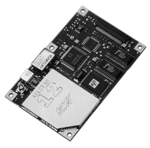
µGPS. I got into GPS around 1990 in an OEM board-level product spin-off program from a certified GPS airborne receiver at CMC in Montreal — we initally called that L1 receiver µGPS because then it was a small GPS board. Later it became known as the AllStar receiver. We found pretty neat applications for the early ’90s — golf-course systems, vehicle tracking, airport vehicle tracking, the start of vehicle nav systems and such.
At NovAtel in Calgary in the early ’90s, we watched things develop through L1/L2 dual frequency, began RTK market applications in survey, geographic information systems (GIS), agriculture, mining and all multitudes of attempts to get new companies off the ground.
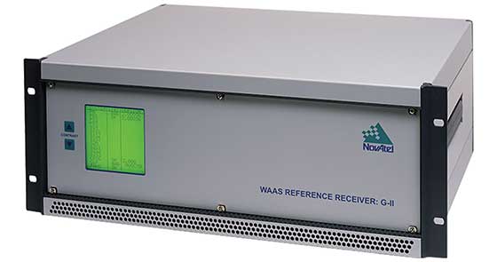
WAAS. Eventually the U.S. Wide-Area Augmentation System (WAAS) program came and swallowed us up through three different prime contractors. Once that Federal Aviation Administration program was running well, we were into programs in Europe, Japan, India and China, and that led into Galileo ground reference receivers. The software qualification work we did on Galileo positioned us to take on mil-spec receiver work, and even anti-jam products.
Then CMC bought NovAtel, and we also joined with CMC to develop a certified airborne receiver. In 2003, NovAtel bought the AllStar OEM product line from CMC — funny how things work out! The joint certified receiver program eventually resulted in a new generation of high-accuracy airborne sensors. We again changed hands in 2007 when Hexagon bought us, and then NovAtel began working closely with Hexagon subsidiary Leica on survey applications. Many new and interesting developments are still going on there.
Nowadays, my interests lie with assisted GNSS and with Rx Networks in Vancouver, which I support and advise. Assisted GNSS comes in many forms, has many avenues in the marketplace, and presents its own unique challenges.
As GPS has evolved into GNSS and into so many, many applications, companies have come and gone but the core of people who drive the industry has grown and acquired new and specialized skills, developing ever more capable technology and products. Even after 47 years of the industry and 30 years of GPS World, we aren’t anywhere close to done.
GMV Innovating Solutions Limited — the U.K. aerospace company belonging to the Spanish technology multinational GMV — has signed a merger agreement with Nottingham Scientific Limited (NSL).
GMV trades in the aerospace, defense, ICT and intelligent transportation systems markets, while NSL is a U.K. leader in satellite navigation and critical applications.
After the agreement, GMV becomes sole shareholder of NSL and sets up the company GMV NSL, to be integrated seamlessly into GMV’s set of companies. NSL was founded in 1998 by Vidal Ashkenazi, a former member of GPS World’s Editorial Advisory Board.
Vidal Ashkenazi
In 2013, as part of its international expansion, GMV rolled out a business development strategy in the U.K. This involved setting up a new company, which came on stream in late 2014 to join the suite of companies and offices in Spain, USA, Germany, France, Poland, Portugal, Romania, The Netherlands, Malaysia and Colombia.
Working from its Harwell innovation center in Oxfordshire, GMV’s main U.K. business is Earth observation, space debris tracking, mission planning, flight dynamics, navigation, autonomy and robotics. Its principal clients include the European Space Agency (ESA) and the European Commission (EC), as well as U.K.’s space agency (UKSA), the Defence Science and Technology Laboratory (DSTL), Innovate UK, ASUK, Satellite applications Catapult and the Science Technology Facility Council (STFC).
Set up in 1998 and with a solid and acknowledged track record in high-tech projects, NSL is a U.K.-based SME specializing in satellite navigation and critical applications. From its Nottingham head office in the East Midlands, NSL offers GNSS-based services, systems, solutions and intellectual property, helping to ensure that navigation and positioning are precise and reliable, secure and protected, resistant and robust. NSL’s major clients include UK Space Agency, ESA, U.K. Government departments, QinetiQ, Inmarsat, and the European Commission.
GMV NSL, 80 strong, will be integrated into GMV’s set of companies, which closed 2019 with a staff of 2,176 and a turnover of more than €236 million. Membership of the GMV powerhouse will enable GMV NSL to rise to even greater challenges and tap into the opportunities offered by the U.K. market, especially the space market, not only in satellite navigation and in critical applications, but also in Earth observation, telecommunications and new technologies, with the overarching aim of winning pole position in Britain’s space sector.
Jesús B. Serrano, GMV CEO (Photo: GMV)
“This merger will enable the resultant firm to tap into significant commercial, technological and operational synergies, boosting GMV NSL’s rate of growth and winning it a place in the space programs of both the U.K. and Europe as a whole,” said Jesús B. Serrano, GMV CEO.
“In our different ways, GMV and NSL are regarded as world leading space companies and this agreement will expand our capabilities and capacity enabling us to successfully tackle even greater challenges and consolidate GMV NSL’s position as the benchmark space company,” Mark Dumville, co-founder and director of NSL, added.
The sheer quality of both teams and the like-mindedness of GMV and NSL on company values, heritage, technological excellence and client satisfaction were all deal clinchers in this merger agreement.
Northrop Grumman Corporation has successfully completed the critical design review (CDR) milestone for the Embedded Global Positioning System/Inertial Navigation System (INS)-Modernization, or EGI-M, program.
EGI-M provides state-of-the-art airborne navigation capabilities with an open architecture that enables rapid responses to future threats. The fully modernized system integrates new M-code capable GPS receivers, provides interoperability with civil controlled air space, and implements a new resilient time capability.
“The completion of this milestone is a key step in bringing necessary navigation capability upgrades to our warfighters,” said Brandon White, vice president, navigation and positioning systems, Northrop Grumman. “With its open architecture and government ownership of the key internal interfaces, EGI-M’s next-generation navigation solution allows the government to quickly insert emerging capabilities from third parties while maintaining cyber security and airworthiness.”
The F-22 is one of the lead platforms for EGI-M integration. (Photo: Staff Sgt. Carlin Leslie/U.S. Air Force)
Northrop Grumman’s unique, modular platform interface design enables backwards compatibility with existing platform footprint and interfaces (A-Kits), allowing current platforms to easily integrate and deploy Northrop Grumman’s EGI-M solution.
At the same time, EGI-M’s modular software and hardware, coupled with government ownership of key interfaces, allows EGI-M to benefit from rapid upgrades with best of breed software and hardware technologies now and in the future.
Northrop Grumman has been on contract for the engineering and manufacturing development (EMD) phase of EGI-M since November 2018. The CDR milestone marks the completion of detailed hardware and software design of the EGI-M product line.
The launch platforms for Northrop Grumman’s EGI-M are the F-22 fighter jet and E-2D early warning aircraft. Additional fixed-wing and rotary-wing platforms across Department of Defense and allied forces have already selected Northrop Grumman’s EGI-M as their future navigation solution.
The E-2D Hawkeye is an American all-weather, carrier-capable tactical airborne early-warning aircraft. (Photo: U.S. Navy)
Effective Sept. 1, Tallysman Wireless Inc. was acquired by Calian Group Ltd. to expand Calian’s reach in the satcom industry to markets requiring smaller antennas used in end-user devices that need a different range of fidelities, according to Patrick Thera, president, Advanced Technologies, Calian.
Calian is a publicly owned Canadian company listed on the Toronto Stock exchange. Its solutions include satellite gateways and infrastructure for RF communications, telemetry, tracking and control systems, space science and earth observation. Calian also provides leading-edge communication products for terrestrial and satellite networks.
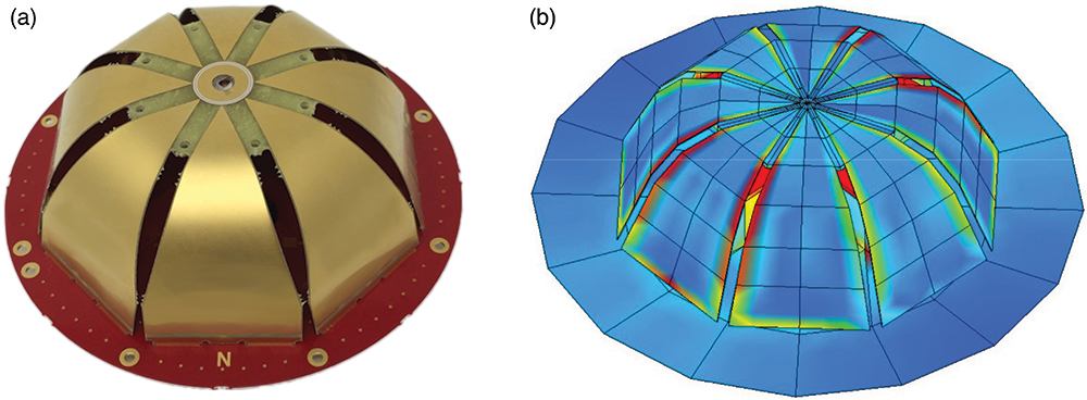
Based in Ontario, Canada, Tallysman designs, manufactures and sells a wide range of GNSS, Iridium and Globalstar antennas and related products into a market with a broad range of vertical applications that include precision reference systems, survey, timing, precision agriculture, unmanned and autonomous vehicles, marine and more. The company also produces cloud-based wireless tracking systems over two-way radio systems and 4G category M cellular systems, for applications ranging from school buses to municipal public works.
The company is widely recognized as a technology leader and is the supplier of high-precision antennas to precision GNNS systems providers. Under the Calian umbrella, Tallysman will continue to operate as it has been, with no changes in product availability, fulfilment, support, management or engineering services.
Tallysman will also continue to invest in research and development, and bring new and innovative GNSS products to the market, the company said.
The definitive agreement is valued at up $24.5 million. Amount paid on closing is $15.7 million (net of cash received) and contains two earnout periods of $4M and $4.8M based on the achievement of a certain level of EBITDA performance over the next 30 months. Tallysman’s results will be consolidated and reported with Calian’s Advance Technology segment.
“This important acquisition supports both customer diversification and service line innovation, two key pillars within our four-pillar growth strategy,” stated Kevin Ford, Calian president and CEO. “The Tallysman acquisition demonstrates Calian continued our focus on innovation and growth. The wide range of products and applications Tallysman brings to Calian expands our product line and entry into new markets. We are excited with the opportunity to support innovation in exciting growth industries such as autonomous vehicles, precision agriculture and wearables. We could not be more pleased to welcome Tallysman to the Calian team.”
Sampford Advisors acted as exclusive M&A advisor to Tallysman.
“We are extremely pleased to join the Calian team,” said Gyles Panther, Tallysman president and CTO states. “We look forward to continuing, profitable growth of our core GNSS businesses with products that we sell to a broad customer base. As a member of the Calian family, we also look forward to leveraging additional resources, new technologies and markets deriving from Calian’s deep expertise in satellite communications.”
“Calian welcomes Tallysman to our team,” Thera said. “The Tallysman product line and services add a complementary component to our ground-based satellite communications business. GNSS is one of the fastest growing markets for satellite ground systems and we are excited to join forces with a leader in this field.”
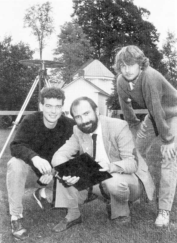
1990: UNB Professor Richard Langley and two graduate students use a GPS antenna (recognize it?) on a tripod to re-measure a historical baseline. (Photo: UNB Perspectives)
When GPS World published its first issue in January 1990, only 15 GPS satellites had been launched, including the 10 prototype or Block I satellites. And four of those early satellites had ceased operation. But there had been enough satellites in orbit for more than a decade to permit early commercial and scientific use of the system. There were even handheld receivers for personal navigation, albeit somewhat larger than those we have today. But it was clear that GPS was going to take off in a big way, and that there was a business case for launching a monthly magazine (bimonthly in its first year) about GPS for professionals in the positioning, navigation and timing communities.
The new magazine was to feature a blend of news, product announcements and articles about GPS, including cutting-edge research on GPS technology and its applications taking place at universities and research institutes around the world. That is why Glen Gibbons, the founding editor of GPS World, reached out to the University of New Brunswick (UNB), an early leader in GPS research and education, to manage a column to be called simply “Innovation.” Glen stipulated that “the column should deal with issues that have broad application and interest and are presented in terms that are accessible to as wide a range of readers as possible.”
Four faculty members were engaged in GPS research at UNB back then: David Wells, Alfred Kleusberg, Petr Vaníček (who famously foretold of the GPS watch back in 1983), and me. Dr. Kleusberg and I volunteered to manage the column and to scour academia and government and industry labs to find authors to write the column’s articles — or to write them ourselves, which we sometimes did. Beginning in 1997, I took over as the sole coordinator of the column — a role I have continued to this day.
There have been close to 300 “Innovation” articles since the first one in the premier issue of the magazine. I’ve also contributed to a number of news and feature articles in the magazine over the years. I might just be the longest-serving active GPS “journalist.” I’m still a full-time teaching and research professor at UNB, and recently took over as the editor-in-chief of The Institute of Navigation’s journal NAVIGATION, but I still have time to write for GPS World and hope to continue to serve the magazine in the years to come.
To get the best measurements of Earth’s atmosphere, you sometimes have to leave it. This November, the Sentinel-6 Michael Freilich spacecraft will do just that.
News from the Jet Propulsion Laboratory
When a satellite by the name of Sentinel-6 Michael Freilich launches this November, its primary focus will be to monitor sea-level rise with extreme precision. But an instrument aboard the spacecraft will also provide atmospheric data that will improve weather forecasts, track hurricanes and bolster climate models.
“Our fundamental goal with Sentinel-6 is to measure the oceans, but the more value we can add, the better,” said Josh Willis, the mission’s project scientist at NASA’s Jet Propulsion Laboratory in Southern California. “It’s not every day that we get to launch a satellite, so collecting more useful data about our oceans and atmosphere is a bonus.”
A U.S.-European collaboration, Sentinel-6 Michael Freilich is one of two satellites that compose the Copernicus Sentinel-6/Jason-CS (Continuity of Service) mission. The satellite’s twin, Sentinel-6B, will launch in 2025 to take over for its predecessor. Together, the spacecraft will join TOPEX/Poseidon and the Jason series of satellites, which have been gathering precise sea-level measurements for nearly three decades. Once in orbit, each Sentinel-6 satellite will collect sea-level measurements down to the centimeter for 90% of the world’s oceans.
JPL-developed instrument
Meanwhile, they’ll also peer deep into Earth’s atmosphere with GNSS-RO to collect highly accurate global temperature and humidity information. Developed by JPL, the spacecraft’s GNSS-RO instrument tracks radio signals from navigation satellites to measure the physical properties of Earth’s atmosphere. As a radio signal passes through the atmosphere, it slows, its frequency changes, and its path bends. Called refraction, this effect can be used by scientists to measure minute changes in atmospheric physical properties, such as density, temperature, and moisture content.
The precise global atmospheric measurements made by Sentinel-6 Michael Freilich will complement atmospheric observations by other GNSS-RO instruments already in space. Specifically, the National Oceanic and Atmospheric Administration’s National Weather Service meteorologists will use insights from Sentinel 6’s GNSS-RO to improve weather forecasts.
Also, the GNSS-RO information will provide long-term data that can be used both to monitor how our atmosphere is changing and to refine models used for making projections of future climate. Data from this mission will help track the formation of hurricanes and support models to predict the direction storms may travel. The more data we gather about hurricane formation (and where a storm might make landfall), the better in terms of helping local efforts to mitigate damage and support evacuation plans.
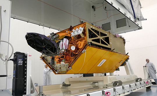
The Sentinel-6 Michael Freilich spacecraft undergoes tests at its manufacturer Airbus in Friedrichshafen, Germany, in 2019. The white GNSS-RO instrument can be seen attached to the upper left portion of the front of the spacecraft. (Photo: Airbus)
A brief history of radio occultation
Radio occultation was first used by NASA’s Mariner 4 mission in 1965 when the spacecraft flew past Mars. As it passed behind the Red Planet from our perspective, scientists on Earth detected slight delays in its radio transmissions as they traveled through atmospheric gases. By measuring these radio signal delays, they were able to gain the first measurements of the Martian atmosphere and discover just how thin it was compared to Earth’s.
By the 1980s, scientists had started to measure the slight delays in radio signals from Earth-orbiting navigation satellites to better understand our planet’s atmosphere. Since then, many radio occultation instruments have been launched; Sentinel-6 Michael Freilich will join the six COSMIC-2 satellites as the most advanced GNSS-RO instruments among them.
“The Sentinel-6 instrument is essentially the same as COSMIC-2’s. Compared to other radio occultation instruments, they have higher measurement precision and greater atmospheric penetration depth,” said Chi Ao, the instrument scientist for GNSS-RO at JPL.
GNSS-RO basics
The GNSS-RO instrument’s receivers track navigation satellite radio signals as they dip below, or rise from, the horizon. They can detect these signals through the vertical extent of the atmosphere — through thick clouds — from the very top and almost all the way to the ground. This is important, because weather phenomena emerge from all layers of the atmosphere, not just from near Earth’s surface where we experience their effects.
“Tiny changes in the radio signal can be measured by the instrument, which relate to the density of the atmosphere,” said Ao. “We can then precisely determine the temperature, pressure, and humidity through the layers of the atmosphere, which give us incredible insights to our planet’s dynamic climate and weather.”
With the help of JPL’s GNSS-RO principal investigator Chi Ao and NOAA’s National Weather Service meteorologist Mark Jackson, this video explains how the GNSS-RO instrument aboard Sentinel-6 Michael Freilich will be used by meteorologists to improve weather forecasting predictions. (Credit: NASA/JPL-Caltech)
But there’s another reason why probing the entire vertical profile of the atmosphere from orbit is so important: accuracy. Meteorologists typically gather information from a variety of sources – from weather balloons to instruments aboard aircraft. But sometimes scientists need to compensate for biases in the data. For example, air temperature readings from a thermometer on an airplane can be skewed by heat radiating from parts of the aircraft.
GNSS-RO data is different. The instrument collects navigation satellite signals at the top of the atmosphere, in what is close to a vacuum. Although there are sources of error in every scientific measurement, at that altitude, there’s no refraction of the signal, which means there’s an almost bias-free baseline to which atmospheric measurements can be compared in order to minimize noise in data collection.
And as one of the most advanced GNSS radio occultation instruments in orbit, said Ao, it will also be one of the most accurate atmospheric thermometers in space.
More on the mission
Copernicus Sentinel-6/Jason-CS is being jointly developed by the European Space Agency (ESA), the European Organisation for the Exploitation of Meteorological Satellites (EUMETSAT), NASA, and the National Oceanic and Atmospheric Administration (NOAA), with funding support from the European Commission and support from France’s National Centre for Space Studies (CNES).
The first Sentinel-6/Jason-CS satellite that will launch was named after the former director of NASA’s Earth Science Division, Michael Freilich. It will follow the most recent U.S.-European sea-level observation satellite, Jason-3, which launched in 2016 and is currently providing data.
NASA’s contributions to the Sentinel-6/Jason-CS mission are three science instruments for each of the two Sentinel-6 satellites: the Advanced Microwave Radiometer, the GNSS-RO, and the Laser Retroreflector Array. NASA is also contributing launch services, ground systems supporting operation of the NASA science instruments, the science data processors for two of these instruments, and support for the international Ocean Surface Topography Science Team.
The 2020 GPS Public Interface Control Working Group Meeting will take place on Sept. 30, announced the U.S. Air Force Space and Missile Systems Center. The meeting includes an open forum to update the public on GPS public document revisions.
The meeting will collect issues and comments for analysis and possible integration into future GPS public document revisions.
The meeting is scheduled from 8:30 a.m. to 4 p.m. (Pacific Standard Time). Portfolio Architect Corp. will host the meeting, which is open to the general public.
Attendees are highly encouraged to participate virtually. The meeting facility in-person capacity may be reduced based on government restrictions; in-person attendees should plan accordingly. Attendees are also expected to comply with COVID–19 health precautions, such as maintaining social distance and wearing a facemask.
Documents Affected
IS-GPS-200: Navigation User Interfaces
IS-GPS-705: User Segment L5 Interfaces
IS-GPS-800: User Segment L1C Interface
ICD–GPS–240 (NAVSTAR GPS Control Segment to User Support Community Interfaces).
Meeting Address:
Coronado Conference Room (17th Floor)
SAIC
200 N Pacific Coast Highway
El Segundo, CA 90245
Innovate UK, the United Kingdom’s innovation agency, has selected Hexagon’s Geospatial division to conduct a research project that will result in faster and higher-precision mapping of railway infrastructure through the use of artificial intelligence.
The project is funded by Network Rail, the owner and operator of Great Britain’s railway infrastructure, under its R&D portfolio and delivered by Innovate UK through the SBRI competition, Innovation in Automated Survey Processing for Railway Structure Gauging, Phase One. A small group of teams was selected for this effort.
Image: Hexagon
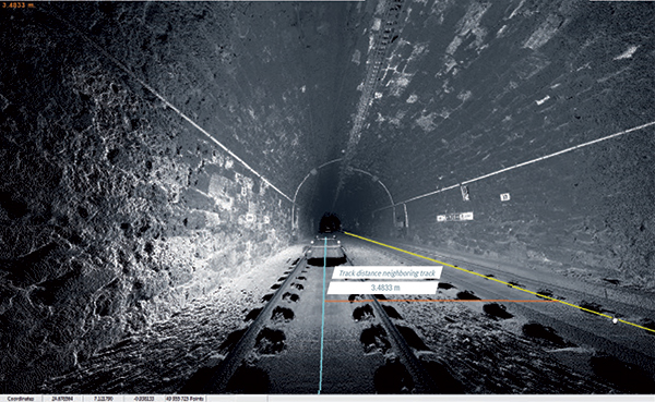
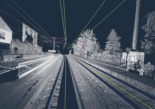
The project will enable Network Rail to automatically identify and measure railway structures from lidar data, saving valuable time and resources, while also improving planning and operations across the rail network. The current, manual process takes analysts months or even years due to the size of the data and the labor-intensive tasks involved.
“The combination of cross-sectional area, shape, length and speed all place a space requirement on today’s railway,” said James Sweeney, senior engineer at Network Rail. “We anticipate this project will offer us a more efficient way to capture, analyse and measure railway features along 20,000 miles of track, which is important to railway safety and the growth and capacity of our network.”
Network Rail collects detailed information about its track and the surrounding features, such as bridges and tunnels. The data is then analyzed to assess clearances between trains and the infrastructure around them, which is key to safety.
Image: Hexagon
The new project aims to automate the extraction and calculation of railway features from sensor data, leveraging AI to automatically analyze point-cloud data, identify different structure types, and perform measurements on the structures. The data will be collected from reality capture solutions from Hexagon’s Geosystems division.
“Network Rail, supported by Innovate UK, is leading the way in the use of AI to automate rail structure identification and measurement,” said Mladen Stojic, president of Hexagon’s Geospatial division. “We are excited to be part of a project that can help transform the gauging process for UK railways.”
The Urban and Regional Information Systems Association (URISA) will be hosting GIS-Pro 2020, the association’s 58th Annual Conference, Sept. 29 to Oct. 2 in a virtual format. The event was originally scheduled to take place in Baltimore, but URISA chose to hold it virtually because of the COVID-19 pandemic.
“With the serious COVID-19 health and physical distancing concerns, hosting an in-person conference this year and putting members, presenters, and staff at risk was a non-starter,” the organization said.
Keynote speakers for the event include Martin O’Malley, the former governor of Maryland; Chris Vaughan, geographic information officer at the Federal Emergency Management Agency; and Juliana Blackwell, director of the National Geodetic Survey.
According to URISA, the program also will highlight a number of relevant topics, including public health, community resilience, equality and social justice, GIS leadership and ethics.
Here’s an overview of the program:
Wednesday, Sept. 23
• Best Practices for GIS Project Planning and Management
• NG911 & the GIS Workflow
• GIS in Emergency Management
• Microsoft Project Software Tutorial
Thursday, Sept. 24
• Experimental Learning Techniques to be More Effective
• Introduction to GIS for Equity and Social Justice
• Navigating a Virtual Landscape for your GIS Career
Tuesday, Oct. 6
• Building Community Using Geospatial Tools
• Unpacking the NENA NG911 GIS Data Model
• Changes Afoot After 2022: State Plane and the Death of the U.S. Survey Foot
Wednesday, Oct. 7
• Preparing for GISP Certification
• Coordinate Systems and Projections
Sessions also will be available on demand for GIS-Pro 2020 registrants after the conference, URISA said. Register for the event here.
The collaboration will provide designers with a power-efficient, high-accuracy GPS solution for battery-operated devices without the additional cost of a dedicated GNSS chip.
“Today’s advanced navigation systems are facing unique challenges when being implemented in power-constrained IoT devices,” said Ambroise Popper, CEO at Nestwave. “By combining Nestwave’s low-power geolocation software with Synopsys’ efficient ARC IoT Communications IP Subsystem, we can deliver a geolocation solution that offers greater accuracy, lower power consumption, and lower cost compared to existing GNSS solutions.”
Ultra-low bandwith IoT applications
The ARC IoT Communications IP Subsystem is an integrated hardware and software solution that combines Synopsys’ DSP-enhanced ARC EM9D processor, hardware accelerators, dedicated peripherals and RF interface to deliver efficient DSP performance for ultra-low bandwidth IoT applications.
Nestwave’s GNSS solution takes advantage of the ARC EM9D processor’s efficient DSP capabilities and ability to add dedicated hardware accelerators or custom instructions using APEX technology to reduce frequency requirements, giving customers additional performance bandwidth.
The ARC EM9D processor is supported by the MetaWare Toolkit, which includes a rich library of DSP functions, allowing software engineers to rapidly implement algorithms from standard DSP building blocks.
Geolocation for emerging applications
Nestwave has developed an ultra-low power, advanced GNSS solution for use in IoT applications. When integrated with an IoT modem such as NB-IoT, Cat M1, LoRa or Sigfox, the solution offers low-cost geolocation for emerging applications such as asset tracking, smart factories, and smart cities, without the need for an external GNSS chip.
“Emerging IoT applications are demanding geolocation functionality with high-accuracy and ultra-low power consumption,” said John Koeter, senior vice president of marketing and strategy for IP at Synopsys. “The combination of Synopsys’ ARC IoT Communications IP Subsystem with Nestwave’s GNSS technology will help designers significantly improve geolocation performance, reduce frequency requirements and lower overall power consumption for battery-powered IoT applications.”
John Fischer, vice president of advanced R&D at Orolia, will join three industry leaders as a panelist in a National Institute of Standards and Technology (NIST) workshop about the federal government’s PNT Executive Order. Fischer is a member of GPS World’s Editorial Advisory Board.
Other workshop panelists include Michael Calabro, chief engineer at Booz Allen Hamilton; Michael J. Lewis, senior staff security strategist at Chevron; and Gerardo Trevino, technical leader in cyber security at the Electric Power Research Institute. The workshop will take place Sept. 15-16.
The PNT Executive Order requires the development of positioning, navigation and timing (PNT) profiles to ensure that the nation’s critical infrastructure is resilient to disruptions or denial of service attacks on GPS signals and PNT data, Orolia said.
NIST, the organization hosting the workshop, is working to provide a ybersecurity framework-based profile to promote the responsible use of PNT services and help critical infrastructure owners make risk-informed decisions to protect their systems.
NIST is also seeking feedback on the Cybersecurity Profile for the Responsible User of Positioning, Navigation, and Timing (PNT) Services Draft Annotated Outline, which can be viewed here.
A GNSS jamming trial will take place from Sept. 8 through Dec. 4 in and around Luce Bay, at Wigtownshire in southern Scotland, conducted by the United Kingdom’s Civil Aviation Authority.
The trial will affect electronic situational awareness devices, UAS command systems and GNSS receivers.
The activity may affect GNSS receivers along with UAS and cockpit devices operating on 433, 868, 915, 2400, 5800 MHz operating up to 40,000FT AMSL within 55NM of 545020N 045548W (West Freugh).
During the trials, impacted systems may suffer intermittent or total failure. Individual events will not exceed two minutes in duration with no more than five events per hour. Activity will take place in the daytime hours between 0830 and 1600.