Esri has released a new mapping app, Air Quality Aware, that fuses data from the EPA’s AirNow program, NOAA’s National Weather Service wind forecast and the American Community Survey to provide location intelligence on current air quality and its impacts on local communities.
At a national level, areas are color-coded according to EPA’s Air Quality Index, with magenta and purple representing hazardous and very unhealthy air quality.
As users zoom in, the map shows the air-quality scores reported at each individual air-quality monitoring station.
Users can click on any station for more information about the pollutants and concentrations reported at that location. They can also search for or click any place on the map to get more information about current and forecasts of air quality, wind speed and insights about the vulnerable population in each place.
Eos Locate for Collector for ArcGIS underground mapping is now compatible with three Subsite Electronics products.
Introduced in 2019 by Eos Positioning Systems, Eos Locate is a real-time, survey-grade solution for mapping underground utilities with ArcGIS field apps. With Eos Locate, one field worker can collect both GNSS locations and locator data (such as depth below cover) for any buried asset including water, sewer, electric, cable, gas, fiber infrastructure and more. They can do so quickly, accurately and without the need for any additional field or office support.
The solution requires an Arrow GNSS receiver, Esri licensing, an iOS device, and a compatible locator.
This expansion adds compatibility for two new utility locator models and one HDD guidance system: the UtiliGuard (with Bluetooth option enabled), UtiliGuard 2, and TK Recon. Eos Locate for Collector combines three core technologies: Eos Arrow GNSS receivers, Esri Collector and the Vivax-Metrotech vLoc Series of locator devices.
“We are extremely excited to expand this popular underground mapping solution to Subsite Electronics customers,” said Eos Chief Technology Officer Jean-Yves Lauture. “Utilities have been asking us to add compatibility, and we are pleased to announce that this integration is now available today, for no extra cost, to our existing customers.”
“At Subsite, we are constantly listening to customer needs and providing solutions accordingly,” Subsite Electronics Senior Product Manager Christopher Thompson said. “We have a lot of customers who perform this type of work, and by partnering with Eos, we are able to provide a solution today to continue providing our customers with the tools and technology for total underground awareness.”
Thanks to the TK Recon integration, it is now possible to map horizontal directional drilling operations in real-time with Eos Locate, for both performing as-built reports and monitoring.
To use Eos Locate with Subsite devices, customers must download Eos Tools Pro (version 1.89 and higher) from the App Store for free. Eos Locate is compatible with both Esri ArcGIS Collector and ArcGIS Field Maps. Follow this manual or watch these video tutorials to get started.
The European GNSS Agency (GSA) has launched the MyGalileoSolution competition. The contest is targeting European innovators and entrepreneurs ready to develop location-based solutions, such as mobile applications, wearable-based solutions, asset management and tracking solutions, or robotics, leveraging Galileo as a source of positioning, navigation and/or timing. A wide participation from all Member States is expected.
GSA has a successful track record in supporting and boosting GNSS-based innovative applications. For years, the agency has been leading several research and innovation initiatives such as the Galileo Masters, Horizon 2020 projects, and more recently European competitions like the 2019 MyGalileoApp and Hackathons across Europe and beyond.
Two tracks for 56 prizes
With a prize pool of almost € 1.5 million, MyGalileoSolution is the largest competition ever organized by the GSA. It consists of two independent and parallel tracks, each one with a list of goals and deliverables.
Track 1 , From Idea to Prototype, aims to develop a beta version of an application or a prototype of a solution implementing an idea, reaching a minimum of 50% of its functionality.
Track 2, From Prototype to Product, aims to develop a fully functional solution ready to be commercialised starting from a beta version of an application or a prototype.
Participants are expected to leverage Galileo’s robust positioning and accurate timing and synchronization capabilities, showing how it can enable the development of the next generation of applications and services across a wide range of areas. In this competition the GSA is challenging innovators in four different areas: Crisis & Emergency Response, Smart Transport for Green Deal, Solution for Digital Age, and Cybersecurity.
Galileo for location-based services
With more than 1.5 billion Galileo-enabled smartphones and more than 51 million GNSS-enabled wearable devices in the market, location-based services (LBS) are booming. Accurate positioning and timing are at the heart of the growth and evolution of LBS, in addition the access to Android GNSS raw measurements has allowed for the creation of advanced GNSS positioning algorithms that enable the development of more ambitious smartphone-based applications.
‘’Galileo has set the trend for dual-frequency chipsets, which provide better accuracy and are more resistant to multipath in urban environments,” said Pascal Claudel, GSA acting executive director. “We are looking forward to seeing innovators launching their disruptive GNSS solutions and turning them into real businesses, hence leading to European growth, competitiveness and sustainability. There is ‘space’ for all types of innovation and we expect the participation of all Member States.”
“Competitions like MyGalileoSolution are a great opportunity to quickly move from idea to market,” said Francesco Fiorito, leader of Argeo, the winning team of the 2019 MyGalileoApp competition. “It is a confidence boost for young entrepreneurs and their capacity to grow and generate new solutions and business,” Claudel concluded.
Deadlines and more information
The deadline for submission for both categories is Sept. 30. Projects will be evaluated in terms of their innovative nature, market potential, feasibility and Galileo relevance by a panel of GSA experts.
Sensonor has launched two new navigation devices. The high-accuracy tactical-grade STIM277H gyro module and STIM377H inertial measurement unit (IMU) are based on experiences and requirements from serving customers in the space segment during the past decade.
The modules have a hermetic aluminum enclosure with a glass-to-metal sealed electrical micro-d connector and a laser-welded lid to secure long-term hermetic operation.
All parts are tested for fine and gross leak to conform to MIL-STD-883J, Class H. The hermetic enclosure protects the system from the external environment and ensures long-term reliability to meet requirements within the space segment and other applications needing exceptional long-term reliability.
The design is tested for a 20+ years’ operating life through high-temperature operating life (HTOL) testing. STIM277H and STIM377H are electrically and mechanically backward-compatible with Sensonor’s other IMU and gyro modules, and provide users with an easy implementation into an existing design.
The components come in dust-free clean-room packaging and have SurTec650 as the only surface treatment. The components are International Traffic in Arms Regulations (ITAR)-free, and have a range of features that can be configured by the customer.
While the new part is still a commercial off-the-shelf (COTS) product and not space-qualified, Sensonor has carried out extensive radiation characterizations to understand the capability of the parts. This data is available on request from Sensonor or can be downloaded.
The parts are a good fit for satellite attitude and orbit control systems (AOCS), launchers, portable target acquisition systems, UAV payloads, land navigation systems, turret stabilization, missile stability and GNSS-supported navigation systems.
Stuart Riley, vice president of GNSS technology, Trimble
Over the past 30 years, GPS World has been at the forefront of the transition of GPS from obscure technology to ubiquitous utility. The magazine was first published before the satellite constellation achieved Initial Operational Capability (IOC). In fact, it preceded Operation Desert Storm, which created unprecedented publicity and demand for GPS equipment; and has documented a period of unprecedented increase in the rate of change in the technical disciplines.
Thirty years after the Wright brothers’ initial flight, commercial air travel remained expensive, uncomfortable, and available to relatively few people. Compare that to GPS and GNSS — in 30 years the technology has moved from 50-pound receivers powered by car batteries to residing in the pockets and on the wrists of billions of people.
In 1978, the year the first GPS Block-I satellite was launched, Trimble was founded. Trimble’s first product was a Loran receiver in 1980, followed by the world’s first commercial GPS product in 1984. The year the magazine was launched, Trimble became the first publicly traded GPS company in 1990. Positioning technology is in Trimble’s DNA and the foundation for helping transform industries such as construction, agriculture, transportation, geospatial and more.
Two factors drove GPS from obsurity to ubiquity: Rapid technological advances (electronics, software, communications, and increasing numbers of satellites) combined with innovations using positioning to benefit large numbers of users across disparate applications. Think of it as “Moore’s Law meets market demand.”
A Malaysian tribe and the Trimble 4000SLD, the first kinematic “backpack” GPS receiver. Weighing 44 lbs. without batteries, the receiver was introduced in 1988. (Photo: Trimble)
The key to GNSS’s growth is its adaptability. By serving a broad range of industries, GNSS manufacturers addressed widely differing needs for precision, form factors, interfacing, and availability of positions. The markets drove the development of more-capable and cost-efficient solutions and injected varying requirements for performance and functionality.
Recent advances illustrate the ability of GNSS technology to react to market needs. Satellite-delivered PPP corrections enable users to achieve real-time centimeter accuracy with fast convergence time almost anywhere on Earth. Low-cost, high-performance inertial sensors boost performance in challenging environments. Software-defined high-precision GNSS receivers, coupled with augmented reality on consumer devices (phones and tablets), open the door to innovation in as-yet-undiscovered directions.
GNSS is playing a key role in a broad range of applications. For example, compact, high-precision receivers are transforming work by delivering higher levels of productivity, reliability, safety and flexibility in industries including automobile and trucking, precision farming, and earthworks and construction. Future applications are expected to increasingly integrate GNSS with other sensors to drive productivity and safety for autonomous applications.
It took less than 30 years to move from static post-processed positioning to holding centimeter precision in your hand. For those of us who experienced the early days, GNSS has changed the world in ways we never imagined. The next three decades will see GNSS embedded into applications unimaginable today.
And to GPS World: Congratulations and thank you for 30 great years of pioneering the education, awareness, and promotion of the GNSS industry.
The extended-range data call milestone was completed in Janesville, Wisconsin, over a more than 5-km distance with speeds greater than 100 Mbps. According to the companies, the achievement redefines the perception of 5G mmWave spectrum as an urban- or high-density-only deployment technology and offers new opportunities to use current infrastructure for broader 5G coverage.
This milestone demonstrates that mmWave can help close the “connectivity divide” and expand broadband services throughout rural, suburban, and urban communities. This breakthrough gives communications service providers a cost effective way to expand their coverage and deliver 5G experience to communities that previously were not serviced or may have lacked a reliable connection.
It will also open the door for new use cases, which will bring 5G benefits to homes and business everywhere, from urban to rural communities. For example, Fixed Wireless Access (FWA) installations can provide a cost-effective way to deliver fiber-like internet speeds wirelessly over mmWave to institutions such as schools, hospitals and town halls, and for addressing some of the “last mile” challenges in rural areas. FWA provides the bandwidth required to support high definition streaming services that can improve experiences like remote education and remote healthcare in suburban and rural environments.
Mike Irizarry, chief technology officer, U.S. Cellular, said, “This is a key strategic milestone in our 5G evolution. Expanding 5G mmWave coverage enables us to offer high-speed broadband services to consumers and businesses in rural areas and underserved communities and reinforces our commitment to technological leadership for rural America. It is a concrete example where U.S. Cellular is driving innovation leadership in extended range technology from Ericsson and promoting the high-power device ecosystem enabled by Qualcomm Technologies.”
“This major milestone of using mmWave for an extended-range 5G data transfer is paving the way to implement fixed broadband services for broad coverage in urban, suburban and rural environments,” said Alejandro Holcman, senior vice president, engineering, Qualcomm Technologies. “With the introduction of the Qualcomm QTM527 mmWave antenna module as part of the Qualcomm Snapdragon X55 5G Modem-RF System, we are empowering operators and OEMs to offer high-performance, extended-range multi-gigabit 5G broadband to their customers — which is both flexible and cost-effective, as they can leverage existing 5G network infrastructure.”
Per Narvinger, head of product area networks, Ericsson, said, “Ericsson is constantly pushing the boundaries of 5G technology to bring its benefits everywhere across the globe. Ericsson has a long and successful track record in extending coverage across generations of mobile technologies. Working with our partners, Ericsson has now demonstrated the commercial viability of long-range 5G radio capability for mmWave spectrum.”
The milestone was achieved by applying extended-range software to commercial Ericsson hardware — including AIR5121 and Baseband 6630 — and a 5G CPE device powered by the Snapdragon X55 5G Modem-RF System with the Qualcomm QTM527 mmWave antenna module.
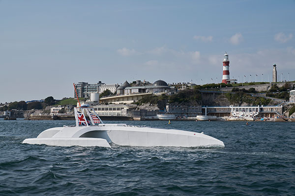
An autonomous ship launched Sept. 16 on a mission to traverse oceans and gather vital environmental data, guided by GNSS and inertial measurement units (IMUs).
Ocean research non-profit ProMare joined with IBM on the Mayflower Autonomous Ship (MAS) — an artificial intelligence (AI) and solar-powered marine research vessel. Following two years of design, construction and training of its AI models, the fully-autonomous trimaran was launched from Plymouth, England.
The ship is guided by both GNSS and IMU technology. It uses two Hexagon | Veripos LD8 receivers, each with two V560 marine antennas. The onboard IMUs include an iXBlue Octans and two Silicon Sensing AMU30s.
Designed to provide a safe, flexible and cost-effective way of gathering data about the ocean, the new-generation Mayflower promises to transform oceanography by working in tandem with scientists and other autonomous vessels to help understand critical issues such as global warming, micro-plastic pollution and marine mammal conservation.
ProMare is coordinating the scientific studie,s working with IBM Research and leading scientific organizations.
MAS features an AI captain built by ProMare and IBM developers that gives MAS the ability to sense, think and make decisions at sea with no human captain or onboard crew. The new class of marine AI is underpinned by IBM’s latest advanced edge computing systems, automation software, computer vision technology and Red Hat Open Source software.
“Able to scan the horizon for possible hazards, make informed decisions and change its course based on a fusion of live data, the Mayflower Autonomous Ship has more in common with a modern bank than its 17th century namesake,” said Andy Stanford-Clark, Chief Technology Officer, IBM UK & Ireland. “With its ability to keep running in the face of the most challenging conditions, this small ship is a microcosm for every aspiring 21st century business.”
Artie — short for Artemis and artificial Intelligence — is a stowaway hitching a ride on the Mayflower who answers questions about the ship, the ocean or himself on mas400.com. (Photo: IBM)
Interactive web portal follows voyage
To enable followers around the world to stay updated with MAS as it undertakes its various missions, IBM and ProMare have also launched an interactive web portal. Built by IBM iX (the business design arm of IBM Services), the MAS400 portal is designed to provide real-time updates about the ship’s location, environmental conditions and data from its various research projects.
Live weather data is streamed from IBM’s The Weather Company, as MAS receives forecast data and insight from the new IBM Weather Operations Center.
‘Octopus’ aboard answers questions
The portal even features a seven-armed, stowaway octopus chatbot called Artie, who claims to be hitching a ride on the ship. (With seven arms, he’s technically a septopus.) Powered by IBM Watson Assistant technology and created in partnership with European startup Chatbotbay, Artie has been trained to provide information about MAS and its adventures in a lively, and accessible format.
“MAS400.com is one of the most advanced ocean mission web portals ever built,” says Fredrik Soreide, Scientific Director of the Mayflower Autonomous Ship project and Board Member of ProMare. “Protecting the ocean depends on our ability to engage the public in important matters affecting its health. This MAS400 portal is designed to do exactly that and tell people where the ship is, what speed it’s travelling at, what conditions it’s operating in and what science we are conducting. Users can even help Artie the Octopus fish out surgical masks, cigarette butts and other increasingly common forms of ocean litter from a virtual ocean of facts and data.”
MAS will spend the next six months in sea trials and undertake various research missions and voyages before attempting to cross the Atlantic in Spring 2021. MAS’s transatlantic voyage will be based on a similar route and pioneering spirit to the 1620 Mayflower which made the same crossing 400 years ago.
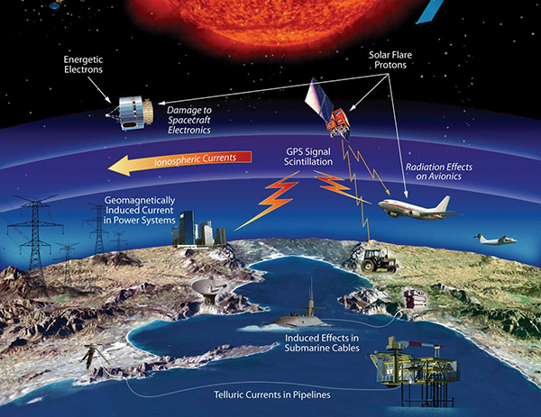
The effects of space weather on critical Earth systems. (Image: NASA)
The United States Congress has passed bipartisan legislation to address how the government deals with threats posed by emissions from the Sun to critical infrastructure such as GPS.
The Promoting Research and Observations of Space Weather to Improve the Forecasting of Tomorrow (PROSWIFT) Act S.881 now awaits signature by the president.
The bill sets forth provisions to improve the ability of the United States to forecast space weather events and mitigate its effects.
It provides statutory authority for the National Science and Technology Council’s Space Weather Operations, Research, and Mitigation Working Group, which coordinates executive branch efforts to understand, prepare, coordinate, and plan for space weather.
The bill directs the Office of Science and Technology Policy, National Oceanic and Atmospheric Administration (NOAA), National Science Foundation, Air Force, Navy, National Aeronautics and Space Administration (NASA), National Security Council, and Federal Aviation Administration (FAA) to carry out specified space weather activities.
The legislation
assigns roles and responsibilities to agencies involved in space weather research and forecasting
ensures agency coordination to better predict severe space weather events and mitigate impacts
calls for coordination between the government and the non-governmental space weather community including academia, the commercial sector and international partners.
Senators Gary Peters (D-MI) and Cory Gardner (R-CO) introduced the first version of the bill in 2016 and a successor passed the Senate in 2017. Reps. Ed Perlmutter (D-CO) and Mo Brooks (R-AL) shepherded it through the House, which passed it Sept. 16.
A link to the live event will be sent to you two hours before the event. Your personalized event URL will be automatically generated by the ON24 system. To ensure receipt of the email, please whitelist this email address by adding it to your contacts: [email protected].
This presentation will begin at 1 p.m. Eastern / 10 a.m. Pacific / 7 p.m. Central European Time on Thursday, October 8th. A recording will also be sent to you the following day so you can watch it on-demand.
Audience members may arrive 15 minutes prior to live time. If you have any questions, please contact event producer Allison Barwacz at [email protected]
Application empowers users with expert visualization and analysis of lidar
Enview, a pioneer in the scalable processing of 3D geospatial data, has launched Enview Explore, a powerful web application that leverages artificial intelligence (AI) and cloud computing to automatically process 3D data at a high speed and scale.
Also, Robert Cardillo, former director of the National Geospatial-Intelligence Agency (NGA), has joined the company’s board of directors. Following an oversubscribed round of funding in May, the company continues to experience growth and momentum in the market.
Enview’s technology has been deployed on thousands of square miles worldwide to protect vital infrastructure and support mission-critical operations. Its unique method for classifying 3D data using neural networks and deep learning techniques reduces time to action by focusing on finding meaningful insights in 3D data.
Previously offered as custom services for organizations such as Pacific Gas & Electric and the United States Air Force, this groundbreaking technology is now available for the first time as an easy-to-use, self-service web application.
Screenshot: Enview
“Enview has built the world’s most scalable AI platform for transforming 3D point clouds into insight and action,” said San Gunawardana, Ph.D., co-founder and CEO of Enview. “We are solving one of the hardest problems in machine perception, and applying it to some of the most grounded and impactful challenges facing society. It is our goal to empower people with the confidence to perceive and navigate a rapidly changing world; Enview Explore is the natural next step in this journey and our team is excited to place this groundbreaking capability directly into the hands of operational end-users.”
Key benefits of Enview Explore include:
The power of 3D data. Three-dimensional unstructured data, such as lidar, contains incredible detail but is painfully slow to analyze manually. Enview solves this problem by combining its novel AI with the power of cloud computing to automate 3D classification and segmentation, giving users scalability that can support even nation-sized datasets.
High speed. While current methods can take weeks or more to process data, Enview provides actionable insights in minutes. Enview Explore utilizes a new and innovative approach that applies AI to 3D data, yielding significantly faster results than traditional lidar software.
Total data control. Enview Explore removes the need for outsourcing lidar to a third party by giving users the ability to perform classification, segmentation, terrain modeling, change detection, feature extraction, and intuitive visualization directly inside the application.
Screenshot: Enview
“With this release, we wanted to show the world that you don’t need to be a professional to get expert analysis from lidar,” said Anthony Calamito, VP of Products for Enview. “Lidar and other 3D data hold tremendous value and provide unparalleled insight over 2D data sources. While unlocking that value traditionally has required an in-depth understanding of specialty software, Enview Explore lets anyone create meaningful insight from 3D data with just a few clicks.“
The company also announced that Robert Cardillo has joined its Board of Directors. Cardillo served as the sixth director of the NGA from 2014 through 2019. In that position, he led the NGA under the authorities of the secretary of defense and director of National Intelligence to transform the agency’s future value proposition through innovative partnerships with the growing commercial geospatial industry.
“Mapping the world in 3D opens new possibilities for national security and mission-critical infrastructure, including some of the most important challenges facing our nation today,” said Cardillo. “Enview has completely changed the game when it comes to what’s possible with lidar visualization and analysis, making unstructured data accessible and easy to use: in other words, creating coherence out of chaos. With a shared purpose and commitment, I look forward to working with the Enview team toward the future the world demands and our customers deserve.”
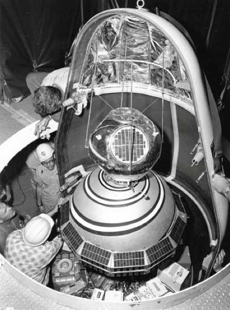
1960: ARPA launched Transit, the first satellite in what would become the world’s first GPS. (Photo: U.S. Army/DARPA)
Sixty-three years ago, on Friday, Oct. 4, 1957, the Space Age began — most everyone alive today is a progeny. The Soviet Union sent a shiny, metal, beach-ball-sized sphere into orbit. Sputnik beeped every second for 21 days before going silent. Its beeps were heard ’round the world. Using the Doppler effect, a listener could tell whether the tiny satellite was moving toward or away from them. Scientists pinpointed the satellite’s exact location by observing it in a single pass, and realized the reverse could also be true. A terrestrial observer’s unknown location could be derived from the known orbit of a single satellite. That idea turned into the first satellite navigation system.
In 1964, the Navy Navigation Satellite System (NNSS) became operational. The highly classified system called Transit was built to support the Polaris ballistic missile submarine fleet. It operated on a small constellation of less than five polar orbiting satellites. With so few satellites in orbit, it could take more than an hour to get a positional fix. Twenty-meter accuracy could be attained by using specially encrypted signals, but these were restricted to submarines. All other users of Transit could only achieve accuracy within 200 meters.
Accuracy was a challenge. The problem was solved the same way John Harrison’s chronometer solved it 300 years earlier, threading together the past and present. More accurate location required more precisely measuring time (see geospatial-solutions.com/from-the-great-pyramids-to-gis-gps/). The problem was solved by two Timation satellites launched in 1967 and 1969 to broadcast a time reference signal. Essentially, the Timation satellites were space-based chronometers.
Timation improved location accuracy, even though it took hours to achieve sub-meter precision. It proved a success, and as a result, in 1967, Transit became available for non-military users, such as surveyors. In fact, everyone today who has ever worked with a reference system is familiar with WGS 84, which was originally based on “Doppler surveying receivers” called georeceivers, referring to measurements from the Transit system. Transit was also known as NavSat as it became more broadly adopted for civilian purposes such as commercial shipping.
In 1973 the Department of Defense sought to combine the success of Transit (NNSS) and Timation into one satellite system, which evolved into the NavStar-Global Positioning System. The first launches began in 1978 and reached a full constellation of 24 GPS satellites in 1993. Since that time, Russia, Europe, China, India and Japan have all created their own constellations. All of those systems combined with GPS make up the global navigation satellite system (GNSS), which totals more than 120 satellites.
Recognizing GPS’s sustained success and positive global impact, in February 2019 the Queen Elizabeth Award for Engineering went to four of the primary developers of the GPS program for their contribution to the world. These four gentlemen are Engineering Stars. On Feb. 12 of this year, President Trump signed an Executive Order further acknowledging the value of position, navigation and timing (PNT) as the invisible infrastructure of modern society. And, on July 1, Capt. “Sully” Sullenberger addressed the Space-Based PNT Advisory Board, stating how GPS has become a universal part of every facet of our lives including financial transactions, transportation, agriculture, rescue operations, surveying and construction.
The GPS satellites are our own constellation and each of them should be named in honor of a scientist or engineer who helped conceive and develop the Transit, Timation and GPS programs; even though the earlier systems no longer exist, their legacy should long be remembered.
From those Cold War origins of a chirping beach ball traveling through space 63 years ago, now more than 2,600 satellites enhance our terrestrial lives providing better communication, location and understanding. We are all children of the stars, albeit stars of our own making.
A new offshore service opportunity for an already proven mini-helicopter UAV, a possible alternative to flying cars, and bulking up UAVs to carry cargo – just a few of this month’s new developments in unmanned aircraft.
Oil Services UAV?
S-100 Camcopter. (Photo: Schiebel)
If you’ve ever gotten close to the Schiebel Camcopter S-100, such as at a trade show, or if you’ve worked with one, you’ve probably noticed that it’s a rugged, weather-hardened vertical take-off UAV.
It would seem that both military and maritime operations would be natural applications — so it’s not surprising that the United Arab Emirates (UAE) Army and German Navy have both bought S-100s.
The U.S. Air Force Research Laboratory (AFRL) also investigated use of the S-100 for detection of improvised explosive devices (IED).
The S-100 is a vertical take-off and landing, unmanned mini-helicopter with a top speed of around 138 mph, a range of just over 100 miles, with two payload bays, an electronics bay, and the ability to carry underslung loads — the all-up payload is 110 pounds. Sensors include an electro-optical/infrared (EO/IR) camera, an electronic support measures (ESM) system for detection and identification of electronic signatures, and synthetic-aperture radar (SAR).
So it’s no surprise that a recent trial demonstrated the S-100’s long-range, high-speed capabilities to deliver parts to a Norwegian offshore oil rig.
Nordic Unmanned and Schiebel flew a demonstration S-100 for rapid delivery of a 3D-printed replacement part from Mongstad out 55 miles to the gas production platform Troll A in the North Sea. This is said to be the first full-scale offshore UAV delivery from shore to an active oil and gas installation.
The demonstration simulated an urgent requirement for a nozzle holder for injecting diesel fuel into the platform’s lifeboat engine. Maintaining safety regulations and production flow from these offshore platforms is essential, but both ship and helicopter emergency trips out to platforms can be risky and downright dangerous in bad North Sea stormy weather — so the UAV option may save lives, time and cost.
Before flying back to base on the mainland, the S-100 also demonstrated its ability to closely inspect the operational platform, and even carried out a simulated search and rescue, locating a dummy in the water and providing live video and location data from its L3 Harris EO/IR camera and an Automatic Identification System (AIS).
Do we really need flying cars?
Where are we with people-carrying drone taxis and cars? To get them in the air for demonstration flights is tricky — there are a lot of i’s to dot and T’s to cross before agencies like the U.S. Federal Aviation Administration (FAA) allow them to fly. There are also plenty of restrictions on where they can fly — certainly not over populated areas. It will undoubtedly happen eventually, but time is money, and regulations will likely outlast the financial supply for most start-ups.
Because of this, one outfit with significant credentials has taken another tack — automating aircraft that have already earned their certified wings.
The original Cessna 172 Skyhawk test flights and certifications successfully culminated in June 1955. The Cessna 208 Caravan gained FAA approval in October 1984. Both General Aviation aircraft have flown since then with established safety and reliability records. The FAA knows what makes a safe airframe, power plant and aircraft flight controls — what’s needed to qualify a remotely piloted, automated flight control system is surely a lot less than the complete aircraft and its existing systems.
Ex-SpaceX software systems director Robert Rose decided that getting his autoflight system past FAA scrutiny would actually be an easier job. He started Reliable Robotics to get drone aircraft flying sooner.
The company has now developed an autonomous platform that can be retrofitted into virtually any fixed-wing aircraft. The system comprises avionics, flight control software, a mechanical hook-up, and a communications system which enables remote command and control, along with a reversionary backup system.
The autonomous system was integrated into a four-passenger Cessna 172 Skyhawk, and was used in an automated, unmanned gate-to-gate demonstration flight. The system underwent a full system safety analysis and test and the unmanned test flight included automatic taxiing, takeoff and landing.
The Skyhawk was flown without a pilot on board over a populated area, which was an essential part of qualifying the Reliable Robotics platform for safe civil use on an already certified passenger aircraft.
For the next test flight of a larger 14-passenger Cessna 208 Caravan, the integrated system again demonstrated full automatic remote landing of the aircraft. Reliable Robotics hopes that continuing certification efforts with the FAA will soon enable them to sell their automation system for certified unmanned passenger aircraft operations.
Cargo UAV
The majority of unmanned aircraft have been small. There’s even a category called small unmanned aircraft systems (sUAS) — so hanging a pizza on one for delivery by suppertime is about the most cargo you might imagine these things could carry.
V20 and V300 cargo UAVs. (Artist’s concept: Pipistrel)
One way to overcome this limitation — as we just saw — is to hook up a sophisticated auto-flight system to a passenger aircraft. Another way could be to build a large cargo-carrying UAV — like the Pipistrel (Slovinia) Nuuva V300, which is claimed to be able to carry up to 1000-pounds of cargo over impressive distances.
The vehicle has eight identical electric motors for vertical take-off and landing, and a gas engine powers a pusher propeller for cruise. The vertical lift electric motor has apparently been certified for airborne use by the European Aviation Safety Agency (EASA).
If the V300 cargo is reduced to 110lb, it looks feasible for it to fly over 1500 miles at up to 8,000ft. Pipistrel claims this operational cargo envelope to be 10 times more efficient than for an equivalent helicopter. Pipistrel has also launched a smaller V20 cargo version with the same offset wing set up and smaller electric lift and cruise propulsion — aimed at last-mile deliveries.
Seems the V20 is available fairly soon, but the V300 still has work to do — presumably certification effort – and won’t be available till 2023.
Until next time
So potential oil-platform service deliveries for the S-100 Camcopter, turning already certified aircraft into passenger carrying unmanned vehicles, and UAVs coming for cargo carrying — all are new, promising and different UAV exploits. Let’s hope they all become commonplace in the coming years.