Blog

  • Spirent’s SimIQ software designed to speed GNSS product testing

    Spirent’s SimIQ software designed to speed GNSS product testing

    Enables greater collaboration and faster product development through I/Q data streaming

    Spirent Federal Systems has released SimIQ, software that allows for earlier and more efficient GNSS testing during product development.

    From software-in-the-loop through to final-form testing, SimIQ enables developers to collaborate across the full design lifecycle through the creation, sharing and replay of I/Q data files.

    “SimIQ Capture allows developers to test their receiver algorithms in the earliest stages of design, minimizing costs and giving designers confidence as they proceed to the hardware design phase.”

    SimIQ has been developed to meet the growing need to test GNSS capabilities earlier to accelerate product development, while simultaneously reducing costs by identifying issues prior to the purchase of hardware components.

    For developers using Spirent’s GSS9000 and GSS7000 simulators, SimIQ extends multi-frequency, multi-constellation simulation capabilities to cover software-only testing needs through the capture and replay of high-fidelity I/Q data files.

    Housed in a single system, SimIQ reads and generates I/Q data with two major components, SimIQ Capture and SimIQ Replay.

    • SimIQ Capture. Allows Spirent GNSS simulators to generate I/Q files containing all the GNSS signal data required to test the algorithms, conformance, and performance of software receivers. It enables the recording of GNSS I/Q data into files hosted in the simulator, helping development and testing teams to validate positioning, navigation and timing (PNT) algorithms before expensive hardware designs.
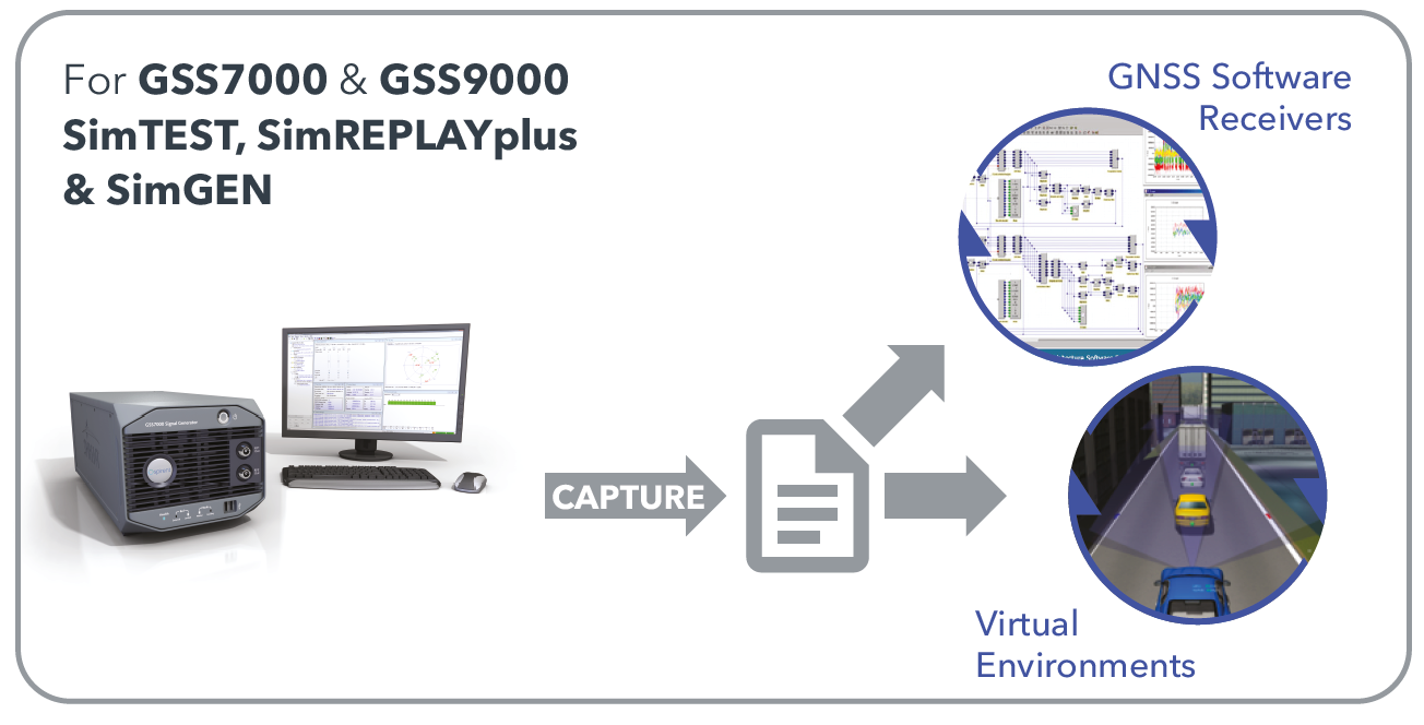
    SimIQ Capture: Record I/Q data from Spirent GNSS simulators into files. (Image: Spirent)
    SimIQ Capture: Record I/Q data from Spirent GNSS simulators into files. (Image: Spirent)
    • SimIQ Replay. Enables the simulator to read any I/Q file containing GNSS data. In addition, it facilitates the generation of RF from pre-recorded interference signals and custom waveforms. The flexibility and unrivalled signal generation architecture of Spirent’s hardware enables the generation of these signals from I/Q files, while maintaining fidelity and quality due to Spirent’s unrivalled signal generation architecture.
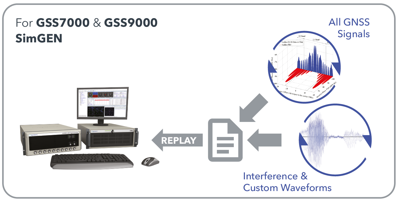
    SimIQ Replay: Generate RF with Spirent GNSS simulators form I/Q files. (Image: Spirent)
    SimIQ Replay: Generate RF with Spirent GNSS simulators form I/Q files. (Image: Spirent)

    Test engineers can accelerate development, and thus save time and resources, by using Spirent simulators during the entire design lifecycle. The new software will bring significant benefits to developers in the defense and aerospace sectors.

    “SimIQ Capture allows developers to test their receiver algorithms in the earliest stages of design, minimizing costs and giving designers confidence as they proceed to the hardware design phase,” said Jen Smith, Spirent Federal’s director of Business Development.

    SimIQ will be available to new and existing customers beginning in the fourth quarter of 2020.
  • VBOX Indoor Positioning System. Speed & position — anywhere.

    Racelogic, the company behind VBOX and LabSat GNSS simulators, has recently launched the VBOX Indoor Positioning System (VIPS) in response to customers’ developing demand to use GPS embedded technology in GPS-denied environments. VIPS delivers <2cm accuracy with an update rate of 100 times a second, making it ideal for dynamic applications, and this accuracy is maintained with seamless transition from GPS to VIPS with reacquisition in less than 0.2 seconds.

    In line with Racelogic’s automotive heritage, VIPS was initially developed for the automotive testing market; however, this has been closely followed by expansion into virtual production motion capture in the film and gaming industry, autonomous robotics, construction, mining and logistics. In fact, this accurate and affordable indoor positioning solution is ideal for almost any application which would normally rely on GPS.

    Learn more.

    Sponsored content by Racelogic

  • GPS World 30th Anniversary Timeline

    GPS World 30th Anniversary Timeline

    Image: GPS World
    Image: GPS World

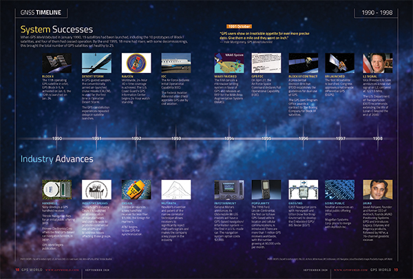
    GPS World’s 30th anniversary GNSS timeline provides highlights in both system and policy development and industry over the past three decades. The timeline originally appeared in the September 2020 Special 30th Anniversary Supplement. Download the PDF.

  • Sept. 17 webinar addresses PNT monitoring of critical infrastructure

    Sept. 17 webinar addresses PNT monitoring of critical infrastructure

    Recent GPS World webinars have focused on a variety of proven, resilient technologies to combat GNSS and positioning, navigation and timing (PNT) vulnerabilities in critical infrastructure.

    Now a Sept. 17 GPS World webinar focuses on how PNT monitoring can further protect critical systems from these vulnerabilities through continuous monitoring and improvement.

    The Orolia-sponsored webinar is free. It is scheduled for 1 p.m. EDT / 10 a.m. PDT / 7 p.m. (1900h) Central European Time. Register here.

    Protecting critical infrastructure is now a national priority for the U.S. and allied countries. Similar to cybersecurity for network systems, effective GNSS and PNT protection involves identifying and monitoring weak entry points, knowing where and when an intrusion occurs, and providing data about new threats to help strengthen the system going forward. Its value applies across all critical infrastructure sectors such as telecom, power grids and data centers.

    Webinar speakers include:

    Photo: Orolia

    John Fischer
    Vice President, Advanced R&D, Orolia

    For more than 15 years, Fischer has been part of Orolia where he works with global navigation satellite systems, wireless, positioning navigation and timing, as well as specialized systems for its customers. Prior to joining Orolia, he specialized in wireless telecom as a founding member of two startups: Aria Wireless in 1990 and Clearwire Technologies in 1997. At Clearwire, he served as chief technology officer in creating wireless broadband equipment for internet connectivity. Early in his career, Fischer worked as a systems engineer in radar, EW, and command and control systems at Sierra Research and Comptek Research. He holds master’s and bachelor’s degrees in electrical engineering and computing engineering from the State University of New York at Buffalo.

    Tim Frost headshot

    Tim Frost
    Strategic Technology Manager, Calnex Solutions

    Tim Frost is a specialist in next-generation synchronisation techniques, having worked with Zarlink Semiconductor, Symmetricom and now Calnex Solutions on packet-based synchronisation technologies. He is an active contributor to the ITU-T, and has also contributed to the AVnu Alliance, Small Cell Forum, Metro Ethernet Forum and IETF. He has a BSc. in Electrical and Electronic Engineering from the University of Leeds, and a MSc. in Computer Systems Engineering from the University of Manchester.

    Francisco Girela headshot

    Francisco Girela
    Americas Tech Responsible, Seven Solutions

    Francisco Girela is the Americas Tech Responsible at Seven Solutions. He holds a Master’s degree in Telecommunications Engineering from the University of Granada. After some time in the private sector, Francisco joined the Timing Keepers group at the same university as a researcher. During his research, he specialized in ultra-accurate time transfer systems and he focused on the development of the White Rabbit technology. He combines his work for Seven Solutions with his studies for a Ph.D. in Telecommunications Engineering. This combination has provided Francisco with a strong technical background on high-accuracy time synchronization and deep knowledge on timing applications in industrial sectors.

    All previous webinars are available on demand and on the GPS World YouTube channel.

  • US Air Force awards $20M to Alion for autonomous navigation

    US Air Force awards $20M to Alion for autonomous navigation

    The U.S. Air Force Institute of Technology (AFIT) has awarded Alion Science and Technology a $20 million task order for a 60-month period to provide Autonomy and Navigation Technology (ANT) development.

    The ANT Center is a forward-looking research center within the AFIT seeking to identify and solve tomorrow’s most challenging autonomy and navigation problems.

    The ANT Center’s goal is to develop navigation technology that ensures the Department of Defense (DOD) can navigate anywhere, anytime, using anything, and to improve the DOD’s ability to conduct autonomous operations.

    Alion will research, assess, analyze and develop the ANT Center’s research in autonomous and cooperative systems, non-GPS precision navigation, and robust GNSS navigation/Navigation Warfare (NAVWAR). This effort supports the AFIT’s mission to advance air, space, and cyberspace power for the nation, its partners, and our armed forces by conducting relevant defense-focused research to enhance technical graduate and continuing education, while supporting the development and evolution of navigation and autonomy technologies, impacting weapon systems across the DOD.

    “Alion has some of the greatest engineering and technology minds in industry partnering side-by-side with our customers to face challenging issues and create technologies, solutions and advancements in innovation to keep our nation ahead,” said Eric Wright, Alion’s vice president of the Integrated Solutions Operation within the Advanced Technology Group. “We are privileged to be working with the U.S. Air Force Institute of Technology to achieve the goals of the ANT Center.”

    This task was awarded under the Department of Defense Information Analysis Center Multiple Award Contract (IAC MAC) issued by the Air Force Installation Contracting Center. This material is based upon work supported by the DOD Information Analysis Center Program Management Office (DOD IAC PMO), sponsored by the Defense Technical Information Center (DTIC) under Contract No. FA807518D0002.


    Photo: U.S. Air Force/Tech. Sgt. Anthony Nelson
    Photo: U.S. Air Force/Tech. Sgt. Anthony Nelson
  • Verizon certifies Quectel’s GNSS smart modules

    Verizon certifies Quectel’s GNSS smart modules

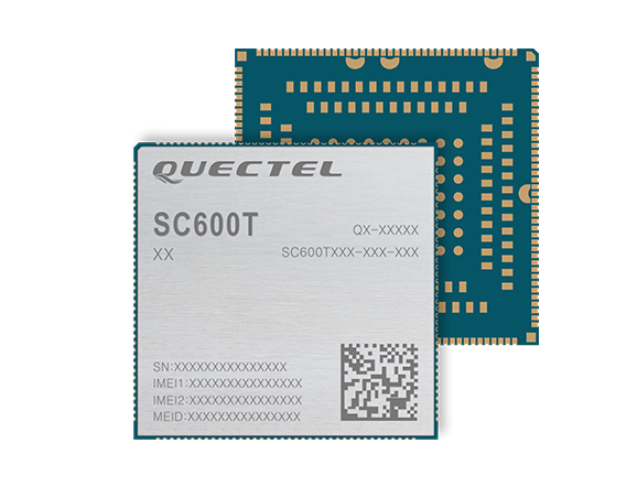
    Photo: Quectel
    Photo: Quectel

    Verizon has approved new-generation “smart modules” offered by Quectel Wireless Solutions for operation on its 4G LTE network.

    The SC600T-NA and SC600Y-NA are industrial-grade LTE Cat 6 modules with an operational and certified built-in Android 9.0 OS.

    The SC600T-NA is based on the Qualcomm Snapdragon MSM8953 and supports Octa-core A53 up to 2.0 GHz, camera 24 MP and video 4K at 30 fps.

    The SC600Y-NA adopts the Qualcomm Snapdragon SDM450 and Octa-core A53 up to 1.8 GHz, camera 21 and video 1080 at 60 fps.

    A multi-constellation GNSS receiver is available in both modules, which is ideal for applications that require fast and accurate fixes, such as in-car video streaming and live video devices, the company said.

    Both modules integrate 2 GB LPDDR3 + 16 GB eMMC flash and support WUXGA display.

    With powerful engines, the two modules are fully integrated with Bluetooth, Wi-Fi capability and strong multimedia functions include support for dual LCDs and dual touch panels with independent display and operation. The modules can support a maximum of four cameras with two working simultaneously. Quick Charge 3.0 technology can facilitate various smart devices, including vending machines, smart cash registers, smart delivery machines and more.

    Designed for North America, both modules work on FDD-LTE bands B2/B4/B5/B7/B12/B13/B14/B17/B25/ B26/B66/B71, TDD-LTE band B41 and WCDMA bands B2/B4/B5.

    “These two modules for North America have passed another industry milestone. They will enable IoT designers, manufacturers and their customers to utilize the latest and leading LTE network technologies from America’s most awarded network,” said Patrick Qian, chairman and CEO of Quectel. “The new generation Cat 6 smart modules are critical for devices to utilize the processing power whenever needed.”

  • Former GPS World advisor Terence J. McGurn passes away

    Former GPS World advisor Terence J. McGurn passes away

    Terry McGurn
    Terry McGurn

    Terence James (Terry) McGurn, former GPS World Editorial Advisory Board member and long-time CIA analyst, died on Aug. 28 at the age of 84, according to an obituary in the Fairfax (Virginia) County Times.

    After a long career in the CIA and U.S. government, McGurn served as a member of the GPS Independent Assessment Team and its successor, the National Space-Based Position, Navigation and Timing Advisory Board. The board provides independent advice to the National Executive Committee on GPS-related policy, planning, program management, and funding profiles in relation to the current state of national and international satellite navigation services.

    McGurn also served as a member of the Independent Review Team sponsored by NASA, which bridged civil and military communities’ GPS issues. He also served on various ad hoc teams that address the criticality of satellite navigation to the nation’s military and civil infrastructure.

    He was a member of the GPS World Editorial Advisory Board and was an active member of the Institute of Navigation. He served the CIA and the broader U.S. government until days before he passed away.

    McGurn was born in Springfield, Massachusetts on Aug. 24, 1935. He grew up in Jersey City, New Jersey, and he graduated from St. Peter’s Preparatory School in 1953. He moved up his draft and served as a radio operator in the 3rd Armored Cavalry Regiment, and then was discharged as an SP-3 in 1956.

    He earned a bachelor’s and masters’ in electrical engineering from the New Jersey Institute of Technology and was Asst. Professor of Physics at NJIT, 1960-69. He earned his doctorate in Electrical Engineering at Stevens Institute of Technology in 1969.

    Terry spent his career at Central Intelligence Agency. A senior analyst and leader, he was appointed to the Senior Executive Service (originally Senior Intelligence Service) where he advised generations of policy leaders and operational leaders of the capabilities of the navigation and positioning of the U.S .and of adversaries and other nations.

    At the CIA, he developed and implemented methodologies that improved the intelligence community’s ability to assess the performance of foreign weapon systems. He also initiated outreach programs to provide the agency’s unique resources to the departments of Defense, State and Transportation in support of U.S. military, political and economic objectives.

    As an expert on the strategic and tactical weapons systems and navigation, guidance and control technologies deployed by potential adversaries, he was able to provide guidance to policy makers regarding the defense of the homeland and of military installations around the world. He briefed at the SECDEF and National Security Council level for decades.

    He retired in 2000, the recipient of the CIA Career Intelligence Medal, and numerous Exceptional Accomplishment and Exceptional Performance Awards.

    As a consultant, he continued to work with CIA and other agencies in the government, including the DOD, State, the newly established Department of Homeland Security and the Department of Transportation, providing technology and analysis for their diverse missions including security issues related to satellite and terrestrial navigation worldwide.

    A long-time resident of Reston, McGurn passed away peacefully at Reston Hospital. He will be laid to rest at Arlington National Cemetery. Reminiscences, condolences and photographs will be posted on this website in the coming months. Memorial donations can be made to the Leukemia and Lymphoma Society or the Animal Welfare League of Arlington.

  • LoRaWAN market projected to grow by 47 percent

    LoRaWAN market projected to grow by 47 percent

    logoThe global LoRaWAN market is projected to reach US$5557.2 million, growing at a very high compound annual growth rate (CAGR) of 47.2% during 2019 to 2027, according to market research firm InForGrowth.

    LoRaWAN is mainly designed for wide range and low-power communications in smart city applications that benefit from wireless battery-operated devices and secure bi-directional communication, mobility and localization services.

    InForGrowth’s LoRaWAN market report provides a detailed analysis of global market size, regional and country-level market size, segmentation market growth, market share, the competitive landscape, sales analysis, impact of domestic and global market players, value-chain optimization, trade regulations, recent developments, opportunities analysis, strategic market growth analysis, product launches, area marketplace expanding and technological innovations.

    Top driving factors

    The report discusses these driving factors in the LoRaWAN market.

    • Growing adoption of smart devices (IoT) in smart cities and smart home projects.
    • The growing adoption of machine-to-machine communication devices due to low cost and less power consumption.
    • Due to the use of IoT in various applications such as smart metering, smart lighting, and livestock monitoring, organizations face challenges regarding the selection of an appropriate connectivity option for specific business use cases.
    • LoRaWAN mainly the private or virtual networks, and connect different endpoints that use different applications (IoT, M2M, smart cities, sensor networks, and industrial automation) in a single data environment. This fuels the demand for LPWANs that offer requisite connectivity, provide long-range access, and extended battery life for connected devices and sensors.

    Market segmentation

    The global LoRaWAN market has been segmented on the basis of deployment, hardware, application and end-user.

    The application of LoRaWAN is based on industry verticals segmented into

    • asset tracking
    • smart metering
    • smart parking
    • smart waste management
    • smart building
    • others.

    Top-end users — those receiving benefits through the LoRaWAN market — can be segmented into

    • agriculture
    • utilities
    • consumer electronics
    • healthcare
    • manufacturing
    • others.

    Region Analysis

    The market is classified into North America, Europe, Asia Pacific, Middle East, Africa and Latin America.

    Europe dominated the market in 2018 and is anticipated to dominate the market in the coming years as well. This is mainly attributed to the rapid adoption of smart agriculture in the region. Large-scale macro-farms are being replaced by family-owned micro-farms across Europe.

    Key players involved in the LoRaWAN market included in this study are Murata Manufacturing Co., Ltd., Link Labs, Microchip Technology Inc., Laird Connectivity, Semtech Corporation, SK Telecom Co. Ltd., Orange S.A. Senet Inc., Comcast Corporation and others.

    Browse the full report.

  • Qualcomm teams with Veoneer on ADAS and autonomous driving systems

    Qualcomm teams with Veoneer on ADAS and autonomous driving systems

    Automotive technology company Veoneer Inc. and Qualcomm Technologies Inc. are working together to deliver scalable advanced driver-assistance systems (ADAS) and collaborative and autonomous driving (AD) solutions.

    The platform will integrate Veoneer’s fifth-generation perception software and driving policy software with the current and future Snapdragon Ride portfolio.

    Qualcomm Technologies intends to make this integrated SoC and software stack platform available to global automakers and Tier-1 suppliers.

    Designed for Tier-1 automakers

    The solutions will be powered by Veoneer’s next-generation perception and driving policy software stack and the Qualcomm Snapdragon Ride ADAS/AD scalable portfolio of systems on a chip (SoC) and accelerators. They solutions range from L1 to L4 systems, designed to create an open platform for Tier-1 suppliers and automakers.

    Designed to address the growing complexities associated with developing ADAS, including safety compliance, the integrated software and SoC platform aims to address the growing needs of the automotive ecosystem for scalable and upgradable solutions, which require highly advanced and power-efficient compute, connectivity and cloud service capabilities across all vehicle tiers.

    Veoneer will serve as a Tier-1 system integrator for the new solution, while continuing its current strategies, which include developing, selling and launching its full line of ADAS and collaborative driving products and systems.

    2024 model vehicles

    The open and programmable platform that both companies intend to develop will be designed to create alternatives for automakers and Tier-1s for more customization opportunities while also charting a course for next-generation automotive architecture evolution. The companies expect the integrated platform to be available through automotive Tier-1 suppliers or directly to OEMs for 2024 vehicle production.

    Veoneer’s software stacks are automotive grade solutions designed to meet the requirements of automakers, regulators and rating agencies globally. It has received top performance ratings and enabled automakers to achieve 5-star safety ratings for European New Car Assessment Program (Euro NCAP) in 2018 and 2020.

    The companies plan to launch a state-of-the-art automotive-grade, functional safety compliant and optimized platform, which will include a full range of optimized NCAP features and up to hands-free driving on highways and slow-moving traffic. The platform will be continuously upgradeable through over-the-air updates.

    The next-generation software stack will be developed in a dedicated organization within Veoneer.

    In January, Qualcomm Technologies announced its latest addition to the company’s growing portfolio of automotive products with the new Qualcomm Snapdragon Ride platform.

    Image: adamkaz/E+/Getty Images
    Image: adamkaz/E+/Getty Images
  • Septentrio expands SECORX-S GNSS receiver product line

    Septentrio expands SECORX-S GNSS receiver product line

    Septentrio’s SECORX-S GPS/GNSS receiver product line offers sub-decimeter accuracy without the need for additional positioning service subscriptions.

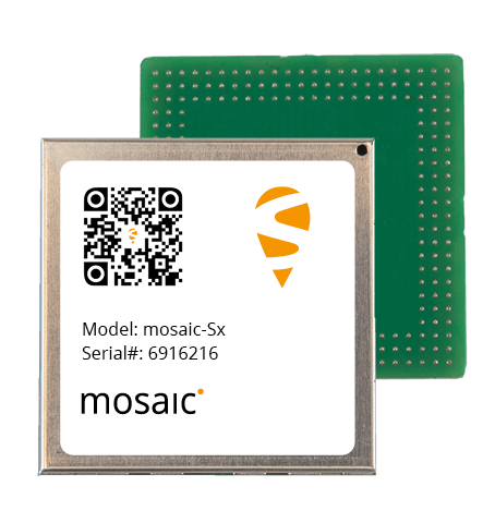
    The mosaic-Sx module. (Photo: Septentrio)
    The mosaic-Sx module. (Photo: Septentrio)

    Septentrio has expanded its SECORX-S product line. The multi-constellation multi-frequency GNSS receivers of the SECORX-S family deliver sub-decimeter positioning out of the box, without the need for any additional correction service subscription or maintenance.

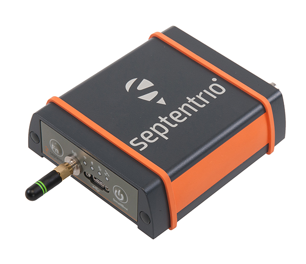
    Users benefit from always-on high accuracy provided by a PPP-RTK correction service integrated directly into Septentrio’s latest core GNSS technology. The SECORX-S product line, already including GNSS OEM boards, now also offers a compact mosaic-Sx module as well as a ruggedized receiver in an IP68 chassis, AsteRx SB Sx.

    By adding modules and boxed receivers to the SECORX-S product line, Septentrio brings its innovative approach of plug-and-play accurate positioning to industrial applications including precision agriculture, UAV, robotics and construction.

    The AsteRs-m2-Sx. (Photo: Septentrio)
    The AsteRs-m2-Sx. (Photo: Septentrio)

    Receivers of the SECORX-S family offer lifelong sub-decimeter accuracy in U.S. and Europe. The PPP-RTK correction service integrated in these receivers uniquely combines near-RTK accuracy with short convergence time.

    “By launching the SECORX-S product family a few months ago, we have taken a ground-breaking step towards easy-to-use and accessible high-accuracy positioning,” said Francois Freulon, head of product management at Septentrio. “Our SECORX-S product range now includes compact modules, versatile OEM boards as well as boxed receivers. With this expansion of the product family our customers now have the flexibility to choose from a wider range of receivers, the one that perfectly fits their needs.”

    For more product details visit the SECORX-S product page or contact [email protected]. To find out more about positioning correction services, see “Septentrio demystifies GNSS corrections.”

  • Harxon introduces X-Survey Pro antenna at Intergeo 2019

    Harxon CEO Jason Yao gives GPS World an overview of the company’s latest developments, including the X-Survey Pro antenna, at Intergeo 2019, which took place Sept. 17-19 in Stuttgart, Germany. According to the company, the X-Survey Pro is a 5-in-1 antenna designed with GNSS antenna, WIFI, BT, 4G and 2.4G, plus 5.8G antennas.

  • U-blox technology platforms support BeiDou-3

    U-blox technology platforms support BeiDou-3

    logoCurrent u-blox GNSS platforms — from u-blox M8 and beyond — support the recently completed BeiDou navigation satellite system modernizations, improving the availability of GNSS positioning services.

    The opening ceremony of the BeiDou-3 global navigation satellite system (GNSS) was held in Beijing on July 31, officially celebrating the expansion of coverage offered by the critical Chinese space infrastructure to a global user base.

    As a global supplier of GNSS positioning and wireless communication technologies, u-blox has been driving technological innovation and deeply involved in the Chinese market for many years.

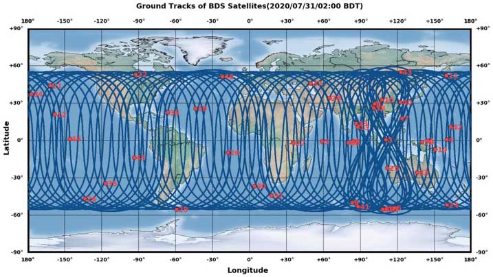
    Tests conducted across China and Europe have shown that including the BeiDou system can improve the positioning accuracy of GNSS receivers when multiple navigation satellite systems are tracked concurrently. When signals are partially obstructed, positioning accuracy can be significantly improved by incorporating the BeiDou system.

    Data shows that in 2019, the overall output value of the Chinese satellite navigation and location service industry reached nearly 345 billion yuan, an increase of 14.4% over 2018, with the output value expected to exceed 400 billion yuan in 2020.

    Chart: China Satellite Navigation System Management Office Test Evaluation Research Center
    Graphic: China Satellite Navigation System Management Office Test Evaluation Research Center

    Additional Services Provided by BeiDou

    The BeiDou system provides a suite of additional services, including satellite and ground-based augmentation services, precise single-point positioning, precise timing and global short message services, laying a solid foundation for BeiDou’s ubiquitous navigation and tracking applications.

    Applications of GNSS technology continue to diversify, leveraging the all-weather, all-time, tracking, navigation and timing services it offers. GNSS technology is penetrating deeper into traditional industrial verticals, such as agriculture, forestry, animal husbandry and fishery, power and energy, as well as in railway and air transportation, including their infrastructure construction and management.

    At the same time, GNSS technology has become an indispensable and “smart” factor in emerging application fields such as the internet of things and the “internet of vehicles,” as well as in innovative applications such as autonomous driving, automatic parking and automatic logistics, and is now commonplace in many industrial and consumer use cases.

    “U-blox has been closely following the modernization of the BeiDou navigation system and is ready to work with partners in various industries to promote the expansion of industry applications, expand emerging markets and jointly create a green industry ecosystem,” said Hamilton Chen, China country manager at u-blox.