NAL Research and VectorNav Technologies — two U.S.-based leaders in assured position, navigation, and timing (APNT) solutions — are joining forces to develop and produce Iridium STL (satellite time and location)-aided inertial navigation systems (INS) designed to meet the increasing demand for resilient PNT in GNSS-denied environments.
Both companies will be exhibiting and discussing the collaboration during the SOF Week Exposition in Tampa, Florida, May 5–8, NAL Research (#3005) and VectorNav (#1941).
Operators of uncrewed systems, in particular, can benefit from implementing an INS solution that leverages NAL’s Iridium STL-enabled APNT receivers to maintain critical operations in areas where GPS/GNSS signals are denied or degraded.
For such applications, VectorNav is leveraging its VN-210E GNSS-aided INS, which combines a tactical-grade IMU with an L1/L2 GNSS receiver in a miniature, board-mount package. Designed for maximum modularity, the VN-210E hosts VectorNav’s tightly coupled INS and includes four serial ports that enable simultaneous integration with multiple external PNT-aiding sources, such as NAL Research’s ALTM Gen2 Mini Iridium STL receiver. When paired, the system provides a high-rate and continuous position, velocity and attitude solution — even in dynamic applications and in GNSS-denied environments.
“This complete offering delivered through our high velocity collaboration with VectorNav will deliver dynamic innovation to the emerging APNT market,” said NAL Research President Robert Bills. “Our partnership streamlines our customers’ implementation of alternative APNT sources. We look forward to helping government and enterprise users achieve operational success by enabling the ability to rapidly implement highly accurate and reliable navigation solutions.”
NAL Research and VectorNav will continue to focus on co-developing product solutions that combine VectorNav’s industrial and tactical-grade INS with NAL Research’s Iridium STL receivers. Future offerings will focus on reducing SWaP-C (size, weight, power and cost), increasing environmental resilience, and supporting MIL-STD compliance for defense and aerospace applications.
“The demand for robust APNT solutions, manufactured at scale and capable of supporting dynamic autonomous systems, is growing rapidly — particularly in the critical maritime domain,” said Jakub Maslikowski, VP of business development for VectorNav. “This collaboration with NAL Research will help to realize the emerging LEO satellite PNT capability and strengthen the U.S. and allied nations’ resilience when operating in contested environments.”
ProStar Holdings, developer of the PointMan Precision Mapping Solutions, and Emlid Tech, European maker of high-precision GNSS equipment, are partnering to bring centimeter-level precision and cost-efficiency to mapping of underground utilities and other critical infrastructure.
The strategic partnership offers ProStar’s PointMan platform, powered by Point One RTK correction services with Emlid’s lightweight and survey-grade GNSS receivers. By combining PointMan’s cloud and mobile precision-mapping solution with Emlid Reach receivers, Emlid’s end-users anywhere in the world have access to an affordable, centimeter-accurate mapping solution.
Emlid offers a range of cost-efficient and lightweight utility mapping equipment. The Emlid Reach RX is a pocket-sized high precision RTK GNSS receiver providing fast setup with no configuration required. For precision mapping trenches in challenging conditions, the Reach RS3 can be used as a base or a rover and provides centimeter-level geopositioning with tilt compensation.
PointMan with Point One RTK corrections provides an easy-to-use mobile mapping solution that uses more than 2,000 base stations communicating with all four major satellite constellations.
“We’re thrilled about this partnership,” said Dmitriy Ershov, Director of Business Development at Emlid. “PointMan mobile mapping software is well-recognized for its versatility and ease of use, and it is exciting to see PointMan continue to evolve, especially with the inclusion of Point One RTK. We are delivering survey-grade accuracy to professionals worldwide in a simple, all-in-one solution.”
Page Tucker, CEO and founder of ProStar, added, “We are strategically aligning with several leading equipment manufacturers to establish a global distribution network. Emlid’s GNSS receivers, combined with PointMan powered by Point One, create a comprehensive and affordable precision mapping solution with unmatched accuracy, coverage, and performance that empowers Emlid’s customers worldwide.”
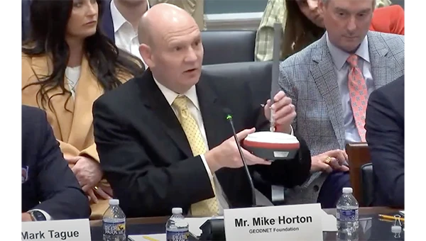
[SPONSORED CONTENT] On April 10, 2025, Mike Horton, project creator of GEODNET, testified before the U.S. Congress on behalf of both GEODNET and the broader DePIN (Decentralized Physical Infrastructure Networks) ecosystem. The testimony showcased how blockchain-powered DePINs are already delivering scalable, cost-effective infrastructure across essential sectors such as internet connectivity, precision navigation, and renewable energy.
This milestone reflects growing recognition from U.S. policymakers and affirms the real-world value and momentum behind decentralized technologies. A proud moment—and a powerful motivator for everyone working to build the future of infrastructure.
A new prototype sensor developed by the NATO Communications and Information Agency has completed a significant round of testing, marking a step forward in NATO’s electromagnetic warfare capabilities. The sensor, GANDALF 4, underwent a series of tests at an advanced anechoic chamber operated by the NATO Support and Procurement Agency. This facility serves as a controlled environment for precise calibration and detailed performance assessment of the sensor’s antenna array, which is critical for ensuring the system’s accuracy and reliability.
GANDALF 4 was developed by specialists at the agency’s Joint Intelligence, Surveillance and Reconnaissance Centre. The system is designed to detect, classify and locate deliberate attempts to interfere with or manipulate GNSS signals. GNSS jamming and spoofing are becoming more frequent and sophisticated, posing challenges to NATO’s operational readiness and resilience. The development of GANDALF 4 is designed to enhance situational awareness in contested electromagnetic environments.
The recent testing phase focused on evaluating the antenna performance of the sensor. Collaboration between the agency’s Electromagnetic Warfare and Surveillance team and the procurement agency’s Ground Based Defence group played a central role in the campaign, facilitating knowledge transfer and improving efficiency, according to the team.
We are pleased to announce that Paul McBurney, Ph.D., has agreed to join GPS World’s Editorial Advisory Board. He is currently CTO and co-founder of OneNav. Prior to that, McBurney was a GNSS architect at Apple. He was co-founder and CTO of eRide, a fabless semiconductor company specializing in high sensitivity GPS and sensor fusion that Furuno acquired in 2009. He also worked for nearly 10 years at Trimble Navigation, as well as Stanford Telecommunications. He received his Ph.D. in Electrical Engineering from Iowa State University in 1988 with a focus on GPS integrity monitoring. He has more than 50 patents in the areas of GPS, AGPS and sensor fusion.
Could new clocks protect planes from spoofing of GNSS signals?
GNSS receiver builders would certainly take advantage of better oscillators. Poor clocks hurt performance, while stable clocks improve performance and provide a source of reliable information. A better oscillator by itself cannot prevent getting spoofed, but it can be an important component of an anti-spoofing regime not only for detection but also for mitigation. At OneNav, we started testing SiTime MEMs oscillators. We are using some SiTime devices that have nearly perfect reference frequency, with less than 100 ppb and amazing shock and temperature stability. They are not cheap, but they are improving the manufacturability for lower cost.
TV broadcasters have petitioned the Federal Communications Commission for permission to provide PNT signals.
In the 1990s, Rosum Corp. of Redwood City, California, first tried to do positioning using TV signals. They were famous for a while and most of their engineers are in GNSS now. The inherent advantages of the multipath mitigation in the signal structure are still unexploited, mainly because TV tower navigation suffers from poor positional dilution of precision as many towers are on the same hilltop. It’s hard to imagine what changed in the manufacturing or business model to put this in the news again. It seems like a tough problem to adopt the silicon in a cell phone to receive this signal. It won’t be an answer for resilience except domestically.
Some claim that quantum systems could transform navigation.
Even navigation-grade IMUs have relatively short viability with meter-level accuracy without GNSS. We are preparing some jamming and spoofing tests with the U.S. Navy’s Stiletto program. The IMU is the limit of the project, and quantum IMUs would make a huge impact.
The Federal Aviation Administration is moving toward approving the use of controlled reception pattern antennas (CRPAs) on aircraft.
This is great news for everyone. It will herald a new movement toward more production, with lower cost and improved performance. We need this technology in everything that moves the public.
On February 24, the sun unleashed an X-class flare, triggering a radio blackout across the Pacific Ocean.
Once again, it’s centered on the equator, where most of the heavy stuff with the ionosphere happens. Research on geomagnetic equatorial ionosphere is on the frontier of ionospheric research. Events like this are wild points that don’t make it into the 3 sigma events. Single frequency receivers that rely on total electron content models for accuracy usually see some impact from these solar storms. The ionosphere has a subtle impact on people all over the world. Did anyone notice their navigation system acting any stranger than usual? Did anyone lose any money on the stock market because the timing accuracy degraded from 5 ns to 20 ns? Did a self-driving car have a blackout? I doubt it. But it’s an important part of a data sheet. Companies such as Novatel and Trimble should comment on how they did.
“Seen & Heard” is a monthly feature of GPS World magazine, traveling the world to capture interesting and unusual news stories involving the GNSS/PNT industry.
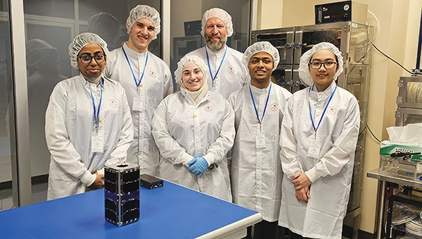
UNB students prepare for second satellite mission
The CubeSat team at the University of New Brunswick (UNB) is developing a second satellite after its first, VIOLET, failed to communicate with Earth. The team is refining its design based on lessons learned from the initial mission. VIOLET, deployed in 2024, was created through a partnership between UNB, the Université de Moncton and the New Brunswick Community College as part of the Canadian Space Agency’s CubeSat Project. This initiative provides students with hands-on experience in designing, building, testing, launching and operating miniature satellites.
GPS technology played a crucial role in preventing disaster during an EasyJet flight, The Daily Mail reported. As the Airbus A320 descended toward Hurghada, Egypt, it approached dangerously close to a mountain range, flying at an altitude of 3,100 ft — just 770 ft above the peak of the mountain. The Ground Proximity Warning System, which relies on GPS-enabled terrain data, alerted the cockpit with warnings such as “pull up, terrain ahead.” This alarm prompted the pilot to perform an emergency maneuver by pulling up the joystick to level off the plane, narrowly avoiding collision and saving all 190 passengers on board.
Gulf of America’ name change leaves decisions for map creators
Photo: TomTom
With the U.S. government now recognizing the Gulf waters as the “Gulf of America” and not the “Gulf of Mexico,” TomTom is introducing a U.S. geopolitical view for its users in the United States; they will see “Gulf of America.” Translations will be available in English, Spanish, French and German, and users searching for “Gulf of Mexico” will find the “Gulf of America.” Map users outside of the United States will see the default map view showing the “Gulf of Mexico.” Users searching for “Gulf of America” will find the existing “Gulf of Mexico” feature. All users will be able to change the view based on their preferences
New ‘surveyor’ app for improved mapping accuracy
Photo: Apple
Apple launched the Surveyor app, a tool designed to enhance the accuracy of Apple Maps by collecting real-world mapping data. According to Apple, Surveyor relies on partner companies and users to gather data along assigned routes. The app focuses on capturing detailed information such as street signs, traffic signals and roadside features, which are then transmitted to Apple for precise map updates. By leveraging community-driven data collection, Apple aims to refine its mapping ecosystem and keep critical details current.
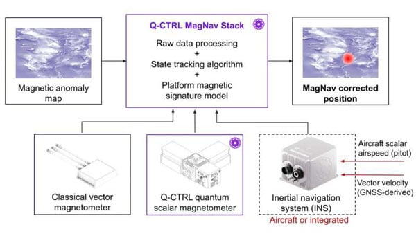
A team of researchers at Q-CTRL, a quantum infrastructure software company based in Sydney, Australia, has completed a successful demonstration of a new quantum navigation system called Ironstone Opal. The group described the system’s operation and performance in a paper posted to the arXiv preprint server.
GPS technology is widely used for navigation in both civilian and military vehicles and aircraft. However, the increasing reliance on GPS has highlighted its vulnerability to outages, which can leave drivers stranded, force pilots to rely on outdated methods and complicate the deployment of military assets. These concerns have driven efforts worldwide to develop robust backup systems or alternatives to GPS.
Q-CTRL’s Ironstone Opal is designed as a backup navigation system and, according to the research team, can deliver accuracy up to 50 times greater than existing GPS backup systems in certain scenarios. The system leverages quantum sensors that are highly sensitive to variations in the Earth’s magnetic field. Because the magnetic field differs depending on geographic location, these sensors can precisely determine an object’s position by reading the field and using artificial intelligence-based software to generate geographic coordinates similar to those provided by GPS.
The research team shared that unlike conventional systems, Ironstone Opal is passive, meaning it does not emit signals that could be detected or jammed by adversaries. The system’s software is designed to filter out noise from vehicles or aircraft carrying the sensors, and the hardware is compact enough for installation in cars, trucks, UAVs and aircraft.
Field trials conducted by Q-CTRL included both ground vehicles and aircraft. The results showed that Ironstone Opal outperformed a high-end inertial navigation system, a standard GPS backup, by up to 50 times in ground tests and by at least 11 times in airborne tests. These trials demonstrated the system’s ability to maintain high accuracy under a range of environmental conditions, altitudes, and maneuvers, with positioning uncertainty as low as 0.01% of the total distance traveled in the best cases.
Q-CTRL’s approach combines proprietary quantum magnetometers with advanced denoising and map-matching software, allowing the system to detect subtle magnetic “landmarks” in the Earth’s structure. The technology is designed to be resilient, unjammable, and suitable for integration into a wide range of platforms, including autonomous vehicles and commercial aircraft.
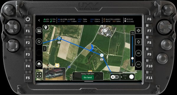
AgEagle Aerial Systems has released its eBee VISION application software, introducing a suite of updates designed to enhance drone navigation in environments where GNSS signals are compromised or unavailable.
The latest software enables autonomous position updates with map referencing, allowing for precise navigation even when satellite signals are jammed, spoofed or blocked, according to the company. This seeks to provide operational continuity for defense personnel, public safety agencies and industrial teams operating in high-stakes, GNSS-denied environments such as dense urban centers, near critical infrastructure or in contested zones with active signal interference.
The update also introduces features such as optical flow stabilization for target lock, which uses visual cues to keep the camera centered on a point of interest during zoom-ins or drone movement. The software allows for adaptive behavior after GNSS recovery or visual repositioning, enabling seamless transitions if the drone’s position suddenly updates due to GNSS recovery or visual geo-referencing.
Additional enhancements include real-time mission duration and return-to-home estimates, optimized cruise speed in windy conditions, high-precision landings using lidar-based altitude calibration, a gimbal auto-recovery mechanism to clear obstructions mid-flight and smart motor speed reduction to prevent overheating during extreme conditions.
AgEagle, founded in 2010, designs and delivers flight hardware, sensors and software for users in energy, construction, agriculture and government sectors worldwide.
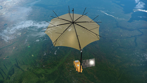
On April 29, the European forest satellite “Biomass” was launched into space from Kourou aboard a European Vega-C rocket operated by Arianespace.
The company Beyond Gravity, based in Zurich, Switzerland, supplied several key products for this mission. Its high-power antenna and navigation receiver will provide the satellite’s precise position in orbit. Also, the satellite will be protected by the company’s thermal insulation.
The European Space Agency’s (ESA) “Biomass” mission will measure forest biomass and will observe the state and development of forests and advance our knowledge of the carbon cycle. Knowing the amount of carbon bound up in forest biomass will sharpen our understanding of climate change and its likely effects on the global carbon cycle. The satellite will orbit Earth at an altitude of 666 kilometers. The mission’s expected lifetime is at least 5.5 years.
“Forests are the green lungs of our planet, providing us with oxygen and storing carbon dioxide,” said Oliver Grassmann, Executive Vice President Satellites at Beyond Gravity. “With the environmental satellite Biomass, we are learning more about the importance of forests to our climate system. Contributing to the functioning of such a groundbreaking climate satellite with key products, like various antennas, our navigation receiver and our multi-layer thermal insulation is a great honor and extremely inspiring for all our colleagues.”
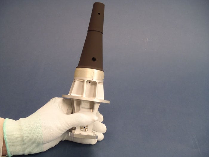
The Biomass mission will feature a new high-power antenna from Beyond Gravity that serves the data downlink needs of new Earth-observing satellites as they gather ever larger quantities of environmental data. The antenna has the size and shape of a large ice cream cone. While more and more Earth observation data from satellites is gathered, the satellite itself becomes smaller. Thus, there was a clear need for a smaller, more powerful data downlink antenna.
The X-band helix antenna design was developed for ESA by Beyond Gravity’s site in Gothenburg, Sweden. Beyond Gravity also provided the S-Band TTC (telemetry, tracking and command) antenna, which acts as a communication and control antenna for the satellite.
A new antenna from Beyond Gravity for data downlink will serve Biomass. It was developed through an ESA General Support Technology program contract with Beyond Gravity in Sweden. (Photo: ESA, Beyond Gravity)
Precise in-orbit position determination. The satellite’s position in space is determined to within centimeters using technology from Beyond Gravity’s site in Vienna, Austria. The more accurate the positioning, the more accurate the data provided by the satellite.
The receiver can process both GPS and Galileo signals. Beyond Gravity’s navigation receivers determine the position of approximately 25 satellites in space. The Beyond Gravity site in Tampere, Finland, produced the Reflector Deployment Interface Unit.
Multi-layer thermal insulation from Beyond Gravity made out of several layers of ultra-thin special polyimide foils will keep the satellite’s instruments at the required operating temperature despite the harsh thermal environment in space. Nearly every European ESA satellite is protected by thermal insulation from Beyond Gravity, which is designed and produced at the company’s sites in Austria. Beyond Gravity also produced the Eddy Current Damper, which is part of the spacecraft’s solar array wing and is providing the damping to slow down the deployment and prevent shocks at deployment completion.
In the letter, the Satellite Safety Alliance (SSA) and 93 companies and organizations stated the need for the Ligado Order to be overturned by President Trump and Congressional leadership.
“The proposed network is designed to inappropriately use spectrum reserved for satellite communications, causing significant interference to other services,” the SSA stated. Interference with GPS is a major concern of the group.
The letter urges the president and the chairs and ranking members of the House and Senate armed services and commerce committees to work with the FCC on granting petitions for reconsideration that will help prevent the building of Ligado’s terrestrial wireless network.
“Ligado’s network would threaten a wide range of critical government and commercial services, including military communications, private satellite communication, GPS, agriculture, aviation, weather forecasting, and more,” the SSA stated.
“For over two decades, Ligado and its predecessors have tried and failed to build a
terrestrial network that wouldn’t harm GPS, national security, and other critical interests,” commented the SSA. “The FCC’s Ligado Order has faced unprecedented opposition, including from 14 federal agencies and over 90 organizations representing huge swaths of the economy — from aviation and agriculture to science and manufacturing. Rarely does any issue garner
agreement from such a wide and divergent group of constituencies.”
Congress found through independent analysis that the Ligado Order poses unacceptable risks of interference to GPS, satellite communications, weather forecasting, and other services, the SSA explained. “Countless federal staff hours and resources have gone to reviewing, debating, and litigating this issue. It is past time the FCC put the issue to rest by granting the pending petitions for reconsideration.”
Merriam-Webster defines a “silver bullet” as a magical weapon, one that instantly solves a long-standing problem. Well, it’s been about 30 years. Despite studies, analyses, tests, demonstrations and much hand-wringing, no silver bullet technology has been identified to back up the myriad GPS dependencies that now permeate U.S. critical infrastructure (CI).
The President, members of Congress, Deputy Secretaries and the President’s National Space-Based PNT Advisory Board have all weighed in to insist that such a backup be put in place to preserve the operational continuity of domestic CI, all to no avail. As a participant in or observer of virtually all these efforts over the past 20 years, I am as familiar with and frustrated as anyone by the lack of progress or urgency.
Now, the Federal Communications Commission (FCC) is the latest to join the fray in late March with a public hearing preceded by a Notice of Inquiry (NOI) on Promoting the Development of PNT Technologies and Solutions, as well as a separate but related Notice of Proposed Rulemaking on improving wireless E911 location accuracy. As with many of the preceding efforts, the NOI is comprehensive and seems all-inclusive regarding both technologies and governance, and it is timely, as it follows many recent press reports on both GPS and CI vulnerabilities. One can hope that its findings will be compelling and capable of implementation, though the sheer range of responses it invites in light of numerous recent industry initiatives for PNT services may only confuse the situation further.
The NOI reflects the recent marketing of PNT services to the government by NextNav, the National Association of Broadcasters (NAB), various commercial SATCOM providers and others. NextNav proposes a commercial PNT service, potentially in conjunction with cellular communications providers, and the NAB proposes a Broadcast Positioning System (BPS) that would include PNT information with television signals using a proposed new broadcast standard. Both entities have separately petitioned the FCC for consideration of rulemaking changes to facilitate their planned solutions. However, their proposals highlight the confusion that can be created by commercial interests that do not take account of some fundamental differences between PNT and communications services.
PNT services have unique requirements for coverage, availability, continuity, integrity and time management that differ from those for communications services, and which dictate how PNT services are provided and employed, particularly when nationwide service is required. This is not to say that the noted PNT initiatives involving market-focused communications providers should not be considered as viable complements to space-based GPS service. However, a viable backup to GPS must be able to provide service in rural and remote portions of the country, where commercial markets are lacking and robust commercial services are not available.
There are significant differences among civil and military PNT service requirements. The Department of Defense (DOD) recognized the reality of this common variation in services, and in its 2019 Department of Defense PNT Enterprise Strategy envisioned a multi-layered PNT architecture consisting of global, regional and local sources of PNT information to support U.S. and allied military systems worldwide. The global PNT layer is space-based and ubiquitous, with 3D position and precise time available worldwide. The regional PNT layer may be space-based or terrestrial with national or international coverage where PNT resiliency must be assured. The local layer may be space-based, terrestrial, and/or autonomous using manmade and natural PNT sources over a limited area based on source design and performance.
In proposing to back up GPS use in domestic CI, both NextNav and the proposed BPS seem to be positioning themselves to serve as the regional layer for the entire country, though both are fundamentally focused on urban markets. NextNav proposes PNT services in urban areas using a network of beacons, potentially partnering with cell phone service providers to provide broader reach, primarily for timing. NextNav also offers a special precise vertical location service for first responders in select metro areas.
The BPS proposal envisions mesh networks of television broadcast antennas, where one TV station is the lead for timing and provides a timing signal to other (follower) stations in a metro area. The PNT information (time, tower location) is contained in a small portion of each main TV broadcast message frame. In effect, it is a new instantiation of a technology demonstrated in 2008 by Naval Academy Midshipman David Taweel in collaboration with Johns Hopkins APL. Using time-managed TV transmissions in Washington and Baltimore, he designed and executed a closed-course UAV flight profile to demonstrate use of signals of opportunity (SOO) for navigation in the absence of GPS. In the same period, a company called Rosum briefly marketed similar PNT services using TV and other SOO transmissions. The technology was stymied by the lack of a nationwide broadcast standard for time-synchronized TV transmissions, which are essential to enable receivers to calculate PNT solutions. This is apparently still a problem today, as the NAB petition to the FCC requests that the latter mandate adoption by TV broadcasters of a new standard that will enable the BPS signal but will also require changes to TV sets and converter boxes. The end user market for a TV-based service is undefined, as is the willingness of station operators nationwide to accept a new standard.
Both NextNav and BPS technologies have performed well within structured demonstrations conducted independently and by the government, and I don’t doubt their technical viability as local layer complements to GPS, particularly for timing. However, as complete backups to GPS positioning and timing services nationwide, issues of adding necessary infrastructure and coordinating precise time management among the range of broadcast system partners and cell network providers become cost prohibitive to serve remote and rural areas where relevant markets don’t exist. Also, TV towers, are sited to provide optimum reception of TV signals in their service areas but not to optimize geometric separation among them that is necessary for positioning services, particularly beyond the margins of metro areas. Finally, neither provider would be able to back up GPS in supporting national security and economic activities in the Alaskan Arctic region and over the northern ocean areas abutting the United States and Canada, where GPS may realistically be threatened in the face of growing competition from U.S. adversaries.
In that context, and with respect to all the studies assessing GPS backups, NextNav stated in an FCC filing, “No one else has proposed a credible solution to the widely recognized and increasingly urgent problem that the United States has no wide-scale [terrestrial PNT] service to complement and back up GPS where the GPS signal is obstructed or when outages occur.”
This is simply not correct, as government studies over years have identified enhanced Loran (eLoran) as the most viable and affordable backup to GPS, and eLoran remains the only terrestrial PNT service that can efficiently back up GPS nationwide, including the Alaskan Arctic and northern oceans. However, since 2015, and despite Congressional support, deliberate political resistance within OMB and resulting DOT/DHS inaction and attempts to shift responsibility to industry have allowed much of the legacy Loran infrastructure to degrade. Costs have risen, and the government is now considering selling the system off, losing access to the valuable sites where eLoran transmissions would be most useful to back up civil GPS use. At the same time, our adversaries in Russia, China and (reportedly) Iran, continue to build out eLoran networks of their own to back up their use of space-based PNT services.
Unless our government accepts responsibility, there will be no PNT silver bullet for domestic CI. Experience shows that industry will not solve this problem alone.
The United States Navy’s Naval Air Systems Command (NAVAIR) has awarded TrustPoint a $1.2 million Small Business Innovation Research Phase II contract. The funding supports the initial delivery and demonstration of TrustPoint’s C-band GNSS service-enabled receivers for the U.S. government. TrustPoint is collaborating with Hexagon U.S. Federal and NovAtel, both part of Hexagon.
This project combines TrustPoint’s C-band services with NovAtel’s GNSS receiver technology, aiming to advance resilient positioning, navigation and timing solutions for military use. The partnership draws on extensive experience in military-grade GNSS equipment and services, and represents a significant step in developing technology that can operate reliably in challenging operational environments.
The contract highlights the increasing importance of frequency and orbital diversity for future navigation and timing needs. With Hexagon as a key partner, TrustPoint is positioned to address the Department of Defense’s evolving requirements for assured PNT, supporting mission continuity even in contested environments