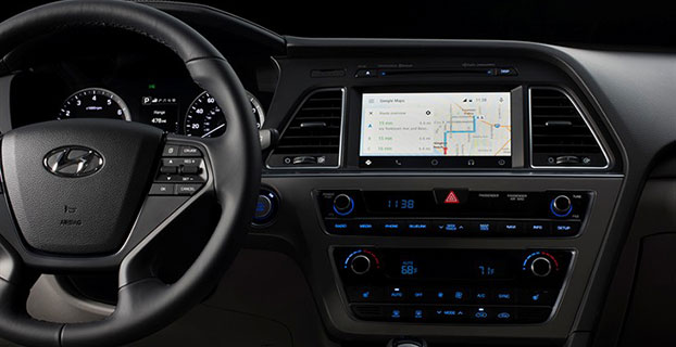
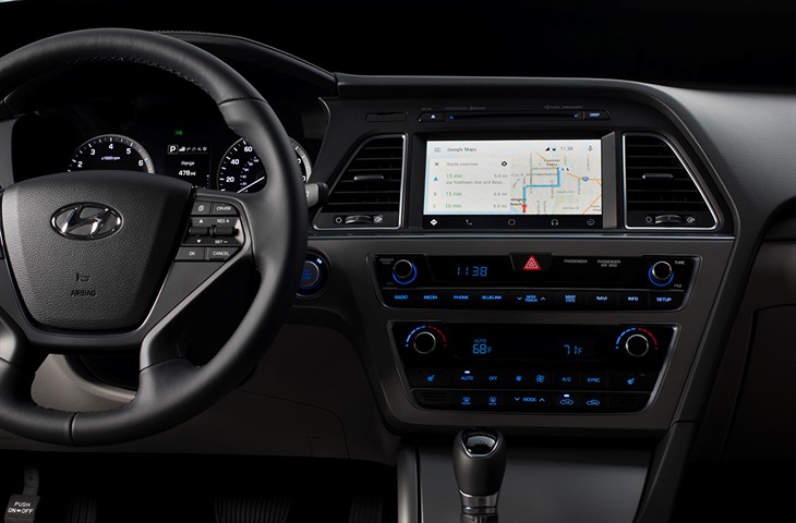
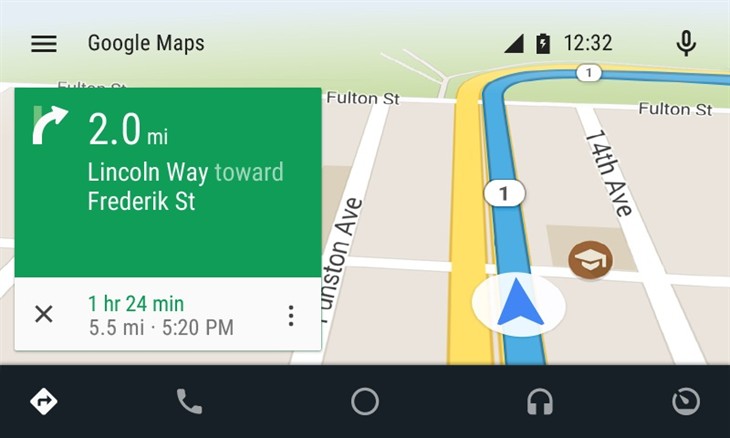
Android Auto in the 2015 Hyundai Sonata. (Photo: Hyundai)
Hyundai has become the first car company to launch Android Auto on production vehicles. Android Auto is premiering on the 2015 Sonata with Navigation at dealerships nationwide, and will later become available on other Hyundai models.
“Android Auto aligns with Hyundai’s core interior design principles of safety, intuitiveness and simplicity,” said Dave Zuchowski, president and CEO, Hyundai Motor America. “We launched this highly anticipated feature on our best-selling Sonata, adding to our promise of value. With the launch of Android Auto, we provide more owners with the experience of cutting-edge technology.”
Android Auto not only brings a high technology experience to Hyundai owners, but also improves safety, Hyundai said. For example, at any given daylight moment across America, approximately 660,000 drivers are using cell phones or manipulating electronic devices while driving, a number that has held steady since 2010. Android Auto helps keep drivers’ eyes and attention on the road by integrating the advanced driving-related functions of the user’s smartphone with the familiar centralized screen, physical controls and microphone of their car.
Furthermore, the smartphone’s screen becomes “locked,” so drivers are not tempted to look down and interact with their phones directly while Android Auto is in use.
Hyundai lists these advantages to Android Auto:
The Google Now card-based experience provides suggested locations and travel times based on the user’s searches, calendar entries and home and office locations, as well as weather information and “now playing” information for music streamed via the phone
App software (navigation, streaming music, etc.) is automatically updated because the apps live on the phone
Natural voice recognition with Google voice actions
Owners can easily bring their personal reminders, suggested destinations, calendar appointments and music preferences with them when they get in their car
Android Auto automatically pairs with the Sonata for phone calls through Bluetooth when connected for the first time via USB
Android Auto has familiar interfaces that are easy to use and have almost no learning curve.
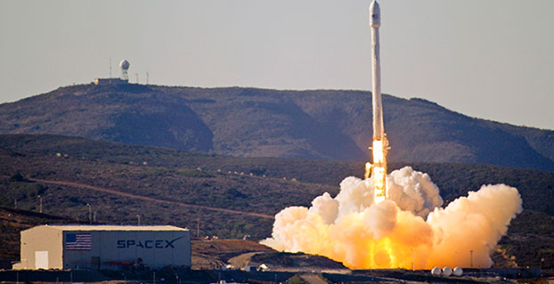
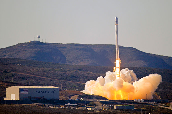
Team Vandenberg launches its first SpaceX launch from Space Launch Complex-4 Sept. 29, 2013. 30th Space Wing’s 1st Air and Space Test Squadron was the lead for all launch site certification activities at Vandenberg for SpaceX as an EELV New Entrant. The squadron evaluated SpaceX’s flight and ground systems, processes and procedures for the upgraded Falcon-9 rocket. (U.S. Air Force photo/Airman Yvonne Morales)
The U.S. Air Force has certified SpaceX’s Falcon 9 rocket to launch military satellites, clearing the way for SpaceX to bid on launches of GPS III satellites. The Air Force announced the decision May 26, which completed a nearly two-year process and establishes a competitor to United Launch Alliance.
SpaceX, based in Hawthorne, Calif., is now eligible for award of qualified national security space launch missions as one of two currently certified launch providers. The first upcoming opportunity for SpaceX to compete to provide launch services is projected to be in June when the Air Force releases a Request for Proposal for GPS III launch services.
“This is a very important milestone for the Air Force and the Department of Defense,” said Secretary of the Air Force Deborah Lee James. “SpaceX’s emergence as a viable commercial launch provider provides the opportunity to compete launch services for the first time in almost a decade. Ultimately, leveraging of the commercial space market drives down cost to the American taxpayer and improves our military’s resiliency.”
This milestone is the culmination of a two-year effort on the part of the Air Force and SpaceX to execute the certification process and reintroduce competition into the Evolved Expendable Launch Vehicle (EELV) program. The Air Force invested more than $60 million and 150 people in the certification effort which encompassed 125 certification criteria, including more than 2,800 discrete tasks, three certification flight demonstrations, verifying 160 payload interface requirements, 21 major subsystem reviews and 700 audits in order to establish the technical baseline from which the Air Force will make future flight worthiness determinations for launch.
“The SpaceX and SMC teams have worked hard to achieve certification, said Lieutenant General Samuel Greaves, commander of the Air Force Space and Missile Systems Center. “And we’re also maintaining our spaceflight worthiness process supporting the National Security Space missions. Our intent is to promote the viability of multiple EELV-class launch providers as soon as feasible.”
“This is an important step toward bringing competition to National Security Space launch. We thank the Air Force for its confidence in us and look forward to serving it well,” said Elon Musk, SpaceX CEO and lead designer.
The certification process provides a path for launch-service providers to demonstrate the capability to design, produce, qualify and deliver a new launch system and provide the mission assurance support required to deliver national security space satellites to orbit. This gives the Air Force confidence that the national security satellites being delivered to orbit will safely achieve the intended orbits with full mission capability.
The SMC, located at Los Angeles Air Force Base, Calif., is the U.S. Air Force’s center for acquiring and developing military space systems. Its portfolio includes GPS, military satellite communications, defense meteorological satellites, space launch and range systems, satellite control networks, space based infrared systems and space situational awareness capabilities.
Fugro has been awarded a contract by subsea contractor DeepOcean for the provision of precise satellite positioning for its fleet.
The contract is valid for three years and also includes the new vessels in DeepOcean’s expanding fleet. The DeepOcean fleet will be equipped with hardware and software developed by Fugro, providing independent positioning solutions on each vessel.
Under the contract, Fugro will supply DeepOcean with three independent decimeter-level satellite navigation systems. Also part of the contract delivery are Fugro’s Starfix.G2+ system, which has a 3D accuracy approaching that of GNSS RTK systems, and Fugro’s Starfix.G4 satellite correction service.
Starfix.G2 is a GPS and GLONASS positioning system based on orbit and clock corrections generated from Fugro’s own expanded network of dual system reference stations. Starfix.G2 is a precise point positioning (PPP) technology, which distinguishes itself from the traditional differential approach as satellite errors are not lumped together but estimated per source, per satellite. The GPS/GLONASS orbit and clock corrections are computed separately, free of ionospheric and tropospheric effects.
Starfix.G4 is a GPS, GLONASS, Galileo and BeiDou positioning system based on orbit and clock corrections generated from Fugro’s network of reference stations. Like Starfix.G2, Starfix.G4 also uses PPP technology. The GPS/GLONASS/Galileo/BeiDou orbit and clock corrections are computed separately, free of ionospheric and tropospheric effects.
DeepOcean is an integrated provider of services and technologies for the subsea industry, including offshore services for oil and gas, offshore renewables and electrical power transmission industries, with offices in Norway, UK, Holland, Brazil, Mexico and Singapore.
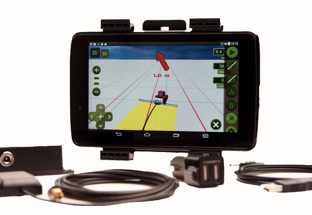
The MachineryGuide package with antenna, receiver and guidance software.
MachineryGuide is a new GPS guidance system for Android that gives farmers the ability to use their smartphones for precision guidance.
With the help of MachineryGuide, the cultivated area and overlaps can be displayed. The guidance application helps farmers in edging along the ideal track by gearing to straight reference lines.
With the application and an antenna from MachineryGuide, farmers can have a simple precision guidance application to improve yield growth, increasing efficiency. Also, fertilizer and pesticide use can be optimized, while machine costs and work hours can be lowered by up to 10 percent, the app designers said.
The application is aimed at managers of small- and medium-sized farms and can be used on a smartphone or tablet. A demo can be downloaded from GooglePlay — the free version can not connect to a real GPS device, but all the functions of the program can be tested.
MachineryGuide sells the software separately; a GNSS receiver + antenna separately; and a package bundle that includes software, GNSS receiver and antenna. The antenna is capable of receiving and processing free corrections (EGNOS, WAAS).
It is heartening to see a burgeoning constellation and its operators move on from doubt to certainty, as Galileo prepares for fuller operational capability and the expectations that scope elicits.
To pick up the thread from last month’s column covering keynote speeches at the European Navigation Conference: plenaries subsequent to the opening session focused respectively on “GNSS for Aeronautical Applications: from GPS to Multi-Constellation with Galileo,” and “GNSS Resilience for Terrestrial & Naval Applications.”
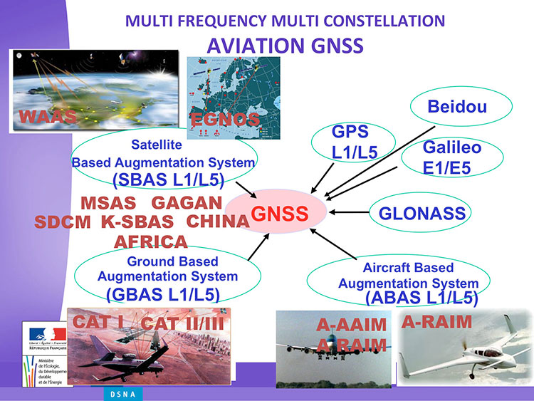
Avionics. Benoit Roturier, GNSS and Performance-Based Navigation program head for the French air traffic control agency, Direction des Services de la Navigation Aérienne (DSNA), reviewed the rather complex assembly of air navigation systems gradually coming together. Not quite — or not nearly — a system of systems, as I understand it, more a conglomeration of systems.
Slide from Benoit Roturier’s presentation on behalf of the French air traffic control agency. (Courtesy of Benoit Roturier)
Multi-constellation GNSS combos, with added context from satellite-based augmentation systems (SBAS), target provision of performance-based navigation (PBN) in all phases of flight, with increased robustness and availability, as well as escalating categories of precision approach and landing. Roturier presaged the SBAS message agreement that also took place in April with his observation that “[The] most benefits are achieved with two constellations — but which ones?” As four constellations and two frequencies deliver “many, many potential navigation modes,” how can air traffic controllers limit complexity while achieving maximum benefits? At the very least, there is a need to agree on main mode and reversion modes.
He gave an overview of upgrades planned, in progress, and completed at airports around France. 141 runways are as of January 2015 equipped with PBN, with GNSS and often EGNOS approaches, compared with 260 still relying on older systems. He concluded with a summary of DSNA views, including “SBAS/EGNOS is seen as a free of charge, performing, mature and here to stay technology, supporting navigation and surveillance (ADS-B) performance requirements.”
By the way, June’s EAGER enewsletter column will cover a recent EGNOS demonstration flight and the current state of runway approaches in Europe. Subscribe here for free.
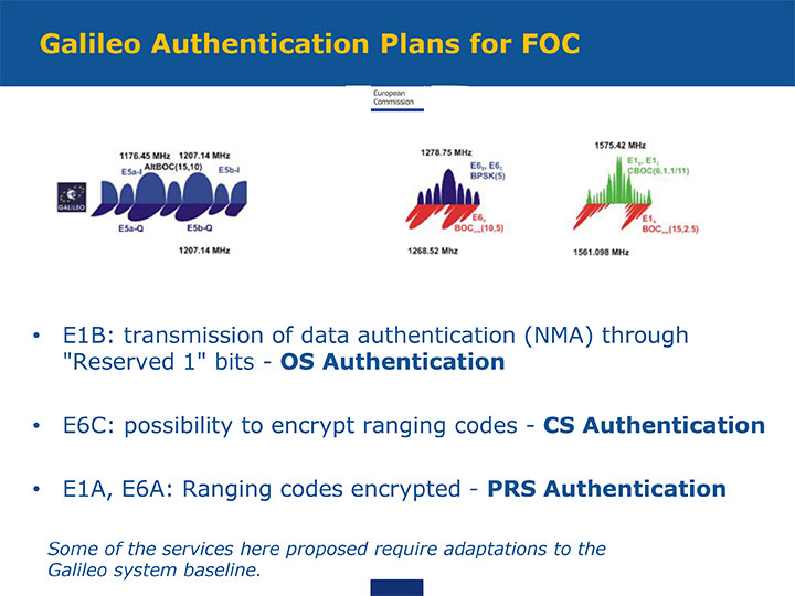
GNSS Resilience. The second plenary, on resilience, brought forth some of the most pointed commentary of the conference. Ignacio Fernández Hernández of the European Commission spoke on Galileo differentiators for resilience: its authentication plans for the Open Service, Commercial Service, and Public Regulated Service, respectively. “The proposed GNSS authentication services are 100 percent backward compatible and interoperable with other receiver-based technologies.”
Slide from presentation by Ignacio Fernández Hernández of the European Commission on Galileo differentiators for resilience. (Courtesy of the EC)
Hernandez proferred the caveat that “some of the required changes to deliver these services (particularly OS authentication) are pending on an impact analysis by industry/ESA and are not yet in the baseline. We hope however to have them in the baseline soon and we’re working hard for it.”
Matteo Paonni of the EC’s Joint Research Centre addressed spectrum management and regulatory issues, specifically the hot-button topic pseudolites. The EC is working closely with the United States and others to limit potential in-band interference risks. Outdoors, pseudolites are clearly undesirable; indoors, they offer some potential, but must be controlled.
Paonni stressed that there is a clear need to protect GNSS spectrum, and that the EC and its member states are doing their utmost to install such protections, and are also promoting GNSS radio-frequency interference detection and mitigation initiatives. Galileo’s PRS is more robust and resilient, but it is not invulnerable. GNSS vulnerabilities should be appreciated and backups put in place for critical systems; backups such as eLORAN, mini atomic clocks, GSM network, and so on.
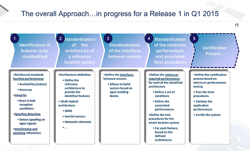
Michel Monnerat of Thales Alenia Space focused on resilience in the road and LBS sectors. With a wide range of environments, devices and applications coming into play, “we need standardization” to specify levels of integrity and levels of performance for each different set of parameters. Thales Alenia is developing just such a set of performance requirements and references, with a first version set for release and discussion soon.
Slide presented by Michel Monnerat of Thales Alenia Space, which is working on a standardization protocol proposal, to be released soon. (Courtesy of Thales Alenia Space)
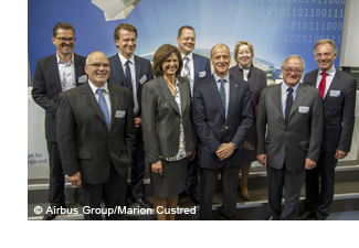
ESA BIC Bavaria, part of the European Space Agency’s Business Incubation Centre (BIC) program, is poised to expand its presence in the aerospace hotbed Bavaria with the opening of another branch office in Ottobrunn near Munich. The Bavarian state government — itself a longstanding ESA BIC partner and supporter — also hailed the program’s new partnership with Airbus Defence and Space at the Ludwig Bölkow Campus in Ottobrunn.
“The new ESA BIC Bavaria branch location in Ottobrunn will enable us to drive the creation of new start-ups based on the research endeavours pursued on-campus,” explained Ilse Aigner, Bavaria’s State Minister of Economics. “Smaller companies in particular have the ability to provide fresh, innovative ideas to Bavaria’s aerospace industry. Much of this sector’s supplier landscape also focuses on the midmarket, which makes these firms’ contributions all the more important.”
Airbus Defence and Space and the ESA BIC program expect their combined efforts to achieve another surge in the commercial use of space infrastructures and technologies.
“The aerospace hub of Ottobrunn and its newly constructed Ludwig Bölkow Campus offer an ideal setting for new companies to grow in collaboration with research and development. This new location promises to integrate Ottobrunn into the ESA BIC Bavaria’s outstanding partner program,” said Thomas Müller, member of the Executive Committee of Airbus Defence and Space and responsible for the Airbus site in Ottobrunn.
“The Ludwig Bölkow Campus is proud to figure amongst ESA’s Business Incubation Centres from now on,” added Alexander Mager, managing director of the Ludwig Bölkow Campus GmbH.
The ESA BIC program now offers start-up entrepreneurs extensive financial and technical support at 20 locations in eight countries: Belgium, France, Germany, Italy, the Netherlands, Portugal, Spain, and the UK.
“ESA’s incubation program has already helped to found 300 companies and is now supporting 100 new start-ups every year, making it the fastest-growing initiative of its kind in the space industry,” said ESA Director General Jean-Jacques Dordain, “and I am glad that the first one created was here in Bavaria with the strong support of the government and of the DLR.”
Anwendungszentrum GmbH Oberpfaffenhofen (AZO), which manages the ESA BIC Bavaria, has been responsible for 98 of these new foundations and the creation of more than 1,200 new jobs, which — along with its impressive network of partners — gives it a place of prominence among ESA’s incubation centers in Europe. Bavaria’s ESA BIC program works closely with the German Aerospace Center (DLR) and the Fraunhofer-Gesellschaft, Germany’s two largest research institutions. Further support is provided by the Wirtschaftsförderung Berchtesgadener Land (a local business-promotion association) and Bavaria’s two most financially sound savings banks, Sparkasse Nürnberg and Kreissparkasse München-Starnberg-Ebersberg.
Start-ups founded through the ESA BIC program benefit from a broad portfolio of space technologies and IP protection services, as well as from their cooperation with the various partners involved, according to ESA BIC Bavaria. “Europe’s space programs in satellite navigation (Galileo), Earth observation (Copernicus), and satellite communications also offer fantastic opportunities to established companies — and especially to those just getting their feet on the ground,” ESA BIC Bavaria said in a statement.
“Airbus Defence and Space is the first industrial aerospace company to join our incubation program,” said Thorsten Rudolph, CEO of AZO. “With its help, we’ll now be able to offer our incubatees and new companies an even wider range of support, from financing and R&D all the way to market launch.”
Sixty seconds may not sound like much, but if given advance warning of an earthquake, people could take cover, trains could stop, and oil rigs could be shut down before the shaking hits.
The earthquake early warning app QuakeAlert, by Early Warning Labs, aims to provide that extra time. The app, with new technology developed in partnership the United States Geological Survey (USGS), will be tested by the USGS, the California Institute of Technology and other university researchers.
QuakeAlert is designed to alert users with a countdown to when shaking will strike their exact location, and tell the user how severe the intensity is expected in their location. The app simultaneously delivers important safety instructions to the user on how to respond if indoors, outside or in a moving vehicle. QuakeAlert will be provided to users free of charge.
The QuakeAlert app uses USGS seismic sensor network data, an Esri GIS backend and the Microsoft Azure cloud to deliver earthquake early warnings. The app is currently in private beta testing with university researchers at CalTech and USGS scientists, and will be available to the public for free once the USGS receives full funding of its early warning program and approves the technology for the public.
Early Warning Labs (EWL) is an Earthquake Early Warning technology developer and integrator in Santa Monica, Calif., and an official research and development partner with the USGS. Early Warning Labs is collaborating with university partners including Caltech, Berkeley and the University of Washington, as well as Esri.
The 2014 Federal Radionavigation Plan, just released from the U.S. Department of Transportation, touches on funding for the Nationwide Differential GPS and the use of eLoran as a precision timing alternative.
The plan is signed by the Secretaries of Defense, Transportation and Homeland Security, and released by the DOT Office of the Assistant Secretary for Research and Technology. A PDF of the document has been posted to the NAVCEN’s website.
Nationwide Differential GPS (NDGPS). The nationwide differential GPS (NDGPS) service augments GPS by providing increased accuracy and integrity using land-based reference stations to transmit correction messages over radiobeacon frequencies. The service has been implemented through agreements among federal agencies including the Coast Guard, DOT and the Army Corps of Engineers, but a decision has not yet been made on funding beyond FY2016:
“The Department of Homeland Security, in coordination with the Department of Transportation, is analyzing the future requirements for the NDGPS to support investment decisions beyond Fiscal Year (FY) 2016. Future investment decisions might include maintaining NDGPS as currently configured, decommissioning NDGPS as currently configured, or developing alternate uses for the NDGPS infrastructure. Contributing factors to these decisions are: (1) the U.S. Coast Guard change in policy to allow aids to navigation (ATON) to be positioned with a GPS receiver using Receiver Autonomous Integrity Monitoring (RAIM), and to allow USCG navigation in all waters using the WAAS receiver; (2) limited availability of consumer grade NDGPS receivers; (3) no USCG DGPS carriage requirement on any vessel within U.S. territorial waters; (4) the Presidential Directive turning off GPS SA; (5) continuing GPS modernization; and (6) the Federal Railroad Administration’s determination that neither NDGPS, nor High Accuracy NDGPS, are requirements for the successful implementation of Positive Train Control.”
eLoran for Timing. eLoran is mentioned in the plan only briefly, in the following excerpt about precision timing alternatives:
“For precise timing applications, chip-scale atomic clocks are now available from at least one company, and others have active research and development programs in the United States and abroad. The U.S. Coast Guard has established a Cooperative Research and Development Agreement to assess a high-power wireless alternative for providing precise time using U.S. government facilities such as mothballed Loran-C sites, upgraded to eLoran capability. If successful, this effort would offer another solution suitable for integration with GPS, or use as an independent complement to GPS, that could together provide highly available and precise timing for many applications.”
One of the marvels of the decade is crowdsourcing. This month I look at crowdsourcing for indoor-location positioning and report findings on GPS in smartphones that provide reliable earthquake warnings. Google has had some issues with mapping crowdsourcing, leading to the temporary suspension of Map Maker. If Google can’t block inappropriate content, it does give pause.
Next, I look at connected cars. Since this fall, four out of nearly 50 self-driving cars driving throughout California have gotten into accidents. With connected vehicles about to start popping out of dealerships, the legality of hands-free driving is belatedly being examined. And, last, INRIX has released an analytics platform that will use the massive data coming from connected vehicles.
Crowdsourcing Indoors. Crowdsourcing has worked for mapping, but what about for indoor location? Sensewhere thinks it can work. The company’s indoor positioning technology learns Wi-Fi mapping through crowdsourcing. The premise is that it gets better over time, with each user’s device adding to the Sensewhere database. For instance, Sensewhere’s ability to determine the location of an office door from the building’s lobby will improve with each trip down the corridor. Although other systems may be more accurate, Sensewhere requires no infrastructure. The company claims accuracy of 10 meters or better.
Sensewhere’s solution doesn’t require the Wi-Fi mapping labor that companies like Skyhook initially undertook. Skyhook engaged in “wardriving,” a peculiar term defined by Wikipedia as “the act of searching for Wi-Fi wireless networks by a person in a moving vehicle, using a portable computer, smartphone or personal digital assistant (PDA).” The term “wardriving” originated from “wardialing,” popularized by the 1983 film War Games in which the lead character, played by Matthew Broderick, has his computer automatically dial phone numbers in search of modems, perhaps the precursor to robocalling.
Crowdsourcing for Earthquakes? The GPS in smartphones can detect the earliest signs of a quake with at least a magnitude of 7. The challenge is to distinguish an earthquake from the usual bouncing and jarring every cell phone encounters. Scientists at the U.S. Geological Survey found that if 103 phones in a defined vicinity record the same displacement, there is an overwhelming likelihood that a quake is occurring. The amount of forewarning is very small and maybe only a few seconds, but it could be enough time for a surgeon to retract a scalpel or a person to take cover.
Is Automated Hands-Free Driving Legal? Given the batch of vehicles with automated driving about to land this year and next, you’d think that the answer would be a resounding yes. But it isn’t clear. Only one state, New York, requires drivers to have one hand on the wheel at all times. The law was enacted in 1967 without the impetus of connected vehicles. A handful of states have legalized automated driving in certain instances. It would be more practical for the federal government to step in to avoid a patchwork of regulation. The automotive industry and other boosters would argue that if automated driving isn’t specifically prohibited, it is legal. However, “drivers” of automated vehicles could find themselves ticketed by police, who could deem hands-free driving as “reckless driving.”
Tapping Big Data from Connected Vehicles. Where you go in your car and what you do in it will be used by INRIX in its new Insights analytics platform. Over the years, INRIX has transformed itself from a purveyor of traffic data to a sophisticated driving and traffic analytics player. The platform will use data from connected vehicles for urban planning, retail site selection and advertising usage, leveraging real-time GPS from a network of 250 million vehicles and devices. INRIX introduced InsightsTrips, a data-as-a-service application for understanding population movement across a metropolitan area. InsightsVolume provides information on how many vehicles typically pass a location.
Android Mascot Defacing Apple’s Logo. Not even Google is impervious to spam attacks and obscene edits. Google has temporarily disabled its crowdsourcing map editing tool, Map Maker. The tool, especially important in countries that lack detailed maps, allows maps to be updated with new geographical features and roads. In April, Google improved its spam detection system in response to escalating hacking, but the company’s efforts were not enough. One recent misdeed was the renaming of a business located near the White House to “Edwards Snow Den,” a play on Edward Snowden. However, the prank that seemed to precipitate Google taking Map Maker offline was an image of the Android mascot urinating on an Apple logo that appeared on a map.
The Android mascot could have used the crowdsourced app Sit or Squat to find a more appropriate venue. Crowdsourcing knows few boundaries.
A number of large companies are making bids to acquire Nokia’s HERE digital mapping company. At least one analyst believes the interest is fueled by future autonomous ambitions. In other location industry news, a new location-based analytics product hits the market.
Signaling the need to control a major location industry segment, Nokia’s HERE digital mapping company is attracting big-name suitors for as much as $3 billion. According to published reports, the bidders include Uber, Audi, BMW, Mercedes, Chinese search engine giant Baidu — and even Facebook.
However, at least one industry insider believes the hoopla for HERE, which is found in a majority of in-dash navigation units worldwide, is being driven by the continued interest in autonomous vehicles.
“Google has been openly working on the concepts required to support AVs for several years and Apple has a skunkworks where they are working on prototypes for an Apple AV. The German luxury car makers realize the bind they could find themselves in — as do all vehicle manufacturers — if Google is able to produce a popular AV-oriented OS that is preferred by owners of AVs over an OS produced by the vehicle manufacturers,” said Mike Dobson, TeleMapics principal, who writes about the topic at www.telemapics.com. “I suspect that Google is really focused on an operating system for autonomous vehicles that can help promote Google’s interest in advertising, but will produce a prototype car to show how the system should work, although avoiding large-scale production. Apple, on the other hand, may be considering producing a vehicle that runs on their OS. So while Google is regarded as a more immediate concern for the automobile industry, the company may also become the vehicle manufacturers’ best friend and trusted supplier, if Apple enters the autonomous vehicle market as a vehicle manufacturer.”
While Dobson believes Uber, which bought mapping company deCarta in March, is playing with fire by bidding for HERE, he says they are clearly concerned what the world of autonomous vehicles might mean for their business. “Within 10 years, Uber will be producing its own fleet of AVs. While owning a map company might be beneficial to them, they might be better off licensing map databases,” he said.
Facebook Not a Good Match
Dobson said that while Facebook, rumored to also be a bidder, can afford the billions to buy HERE, there does not appear to be a significant strategic advantage for them in doing so. “While (Facebook) is experimenting with geographical databases, it is unclear to me that they would significantly benefit from owning a spatial database, as opposed to licensing the data, although their concern may be driven by a fear that the data might not be freely licensed after the company is acquired, say, by a competitor,” he said.
The problem with the automotive consortium and Uber that have surfaced in the quest for HERE, the company once called Navteq — and acquired by Nokia for more than $8 billion in 2007 — is that none are data companies — with the background and nuances of creating spatial databases,” Dobson said.
“From my perspective, that means none of the current bidders are ideal candidates to manage the company. Like Nokia, these companies may not actually know what to do when they win the auction,” he said. “During the eight years that Nokia has owned HERE, the mapping asset has been devalued and improperly positioned for growth. I do not know how much more mismanagement the team at HERE can take before the company and its navigation databases becomes non-competitive.”
Dobson says that Uber, Facebook, Baidu, and the German car manufacturers do not yet understand the expense of upgrading and maintaining HERE’s mapping database for the demands of the autonomous vehicle market. “Buying HERE for ‘internal’ use only would be a significant mistake, so any potential buyer is going to need to continue to sell data to all channels, even those owned by potential competitors. This simple reality will cause any of the buyers who have surfaced so far a lot of heartburn in the future,” he said.
Dobson says the clear winner for the future of HERE is the German automotive consortium of Audi, BMW and Mercedes, with its reported alliance with Baidu. “I do not regard this combo as an optimal owner, but the mix of interest may help keep HERE at the forefront of producing high-accuracy navigation databases — although the extent of map coverage may be a casualty of this ownership team,” he said.
New Location Analytics Product Hits the Market
A new location analytics product is hitting the market in a more and more crowded indoor-positioning field. The differentiator, says Cloud4Wi about its new Fogsense product, is that the unit constitutes the location industry’s smallest Internet of Things Wi-Fi device that is tailored to retail outlets, coffee shops, restaurant chains and shopping malls with presence analytics and location-based services.
The device, which contains Broadcom’s WICED chip, will feature Bluetooth low-power technology in the new version in (the fourth quarter), said Elena Briola, Cloud4Wi’s chief marketing officer. The new BLE version will enable Apple iBeacon and location-aware mobile applications.
“We not only track the position of visitors and customers in the venue, we aggregate this data in valuable analytics and we provide applications to deliver targeted localized services based on these analytics,” she said.
The device is also USB-powered, allowing businesses to scale its integration with both single and small venues, where Fogsense receives power from laptops and point-of-sale (POS) devices, the company said.
“Customers increasingly expect Wi-Fi to be available wherever they go. Businesses can collect valuable data about their customers, better understand their behavior and deliver more personalized marketing initiatives,” Briola said.
Like many location analytics companies, Cloud4Wi believes the new product will enable businesses to design push-targeted, localized marketing and advertising messages based on an assessment of the customer’s behavior at the venue.
The company evokes the much-quoted ABI Research statistics that more than 1 million location retail deployments will occur by 2020.
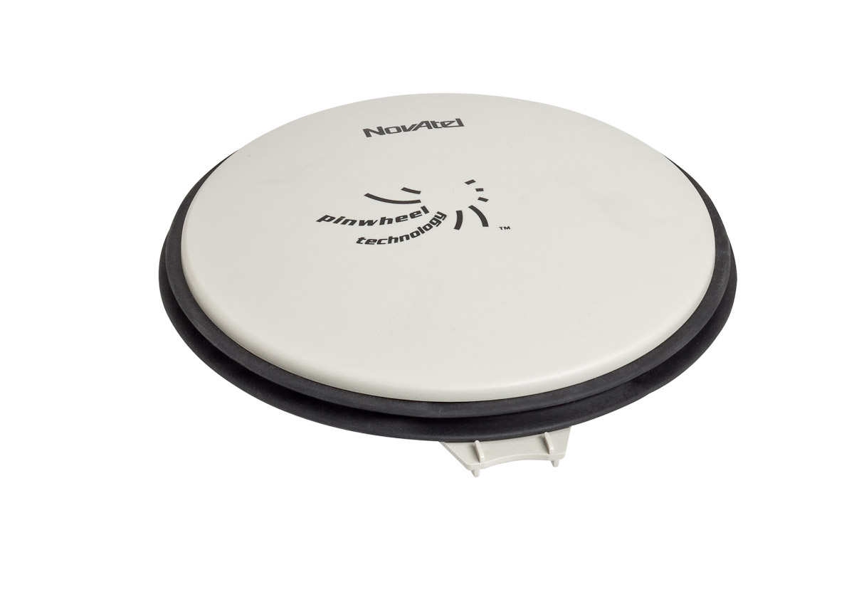
NovAtel Inc. has introduced the GPS-713 pinwheel antenna, available in two configurations: the standard GPS-713-GGG-N and the L-Band capable GPS-713-GGGL-N.
Both antennas provide enhanced Inmarsat interference rejection, allowing tracking of GNSS signals in the presence of high-powered Inmarsat transmitters typically found on marine vessels. The antennas receive GPS L1, L2, L5; GLONASS L1, L2, L3; BeiDou B1, B2; and Galileo E1, E5a/b frequencies, optimizing global satellite tracking capabilities. Customers can use either antenna for GPS-only or multi-constellation applications, providing excellent flexibility and reduced equipment costs, NovAtel said.
Designed for baselines of any length and easy installation, the phase center offset of these antennas remains constant as the azimuth and elevation angle of the satellites change. The antenna shares the same form factor as other NovAtel GPS-700 series antennas, and is enclosed in a durable, waterproof housing. Its compact, lightweight size makes it suitable for a wide variety of environments and applications.