Marketsandmarkets.com is offering a new report on the precision farming market, with forecasts to the year 2020. The report covers various technologies and components, including GNSS.
The report is titled “Precision Farming Market by Technology (GPS/GNSS, GIS, Remote Sensing & VRT), Components (Automation & Control, Sensors, FMS), Application (Yield Monitoring, VRA, Mapping, Soil Monitoring, Scouting) and Geography – Global Forecasts to 2020.”
According to marketsandmarkets.com, “Precision farming is growing rapidly from its infancy towards maturity. Driven by advancements in data management, precision farming has a remarkable impact on traditional approaches to farming. Applying technological developments in data collection and geo-location tracking, precision farming uses technology to optimize yield and detect operating efficiencies as well as deficiencies. Precision farming applications guide farmers about the right time to plant and harvest, and the amount of fertilizers and pesticides needed for better yield production. This information helps cut down input costs, fuel usage, and labor, and negate the environmental impact. Farmers across the globe have been benefitted due to innovations in precision agriculture.
“Major drivers for this market are augmented yield and profitability, which are contributing factors for farmers to opt for precision farming; other drivers like energy and cost saving, and government assistance have also been contributing to the market growth. Major restraints like high initial investments, and lack of awareness and their impact analysis are also covered under this study.
“The total precision farming market size is expected to grow at a CAGR of 12.2% from 2014 to 2020 and reach $4.55 billion by 2020. The report analyzes the precision farming supply chain, giving a very clear insight of all major segments and supported segments to the industry. The report also provides a detailed scrutiny of the Porter’s five force analysis for the market. All five major factors in these markets have been quantified using internal key parameters governing each of them.
“The report also includes company profiles of leading players in this industry with their recent developments and other strategic business activities. The competitive landscape section of the report entails key growth strategies and detailed market share analysis of key industry players. Some of the major players in the precision farming market are AgJunction Inc. (U.S.), Ag Leader Technology (U.S.), Dickey-John Corporation (U.S.), Teejet Technologies (U.S.), Deere & Company (U.S), Trimble Navigation System (U.S.), Precision Planting Inc. (U.S.), ACGO Corporation (U.S.), Topcon Precision Agriculture (U.S.), and Raven Industries Inc. (U.S.).”
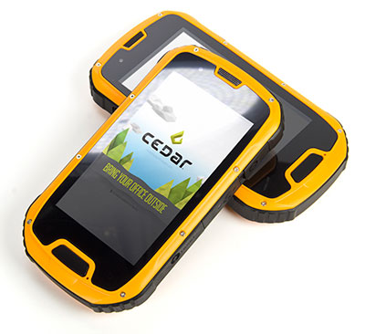
The CT4 and other rugged handhelds by Cedar Tree Technologies will now be available through Juniper Systems.
Juniper Systems is merging its subsidiary company, Cedar Tree Technologies, into Juniper Systems. The move will allow customers to purchase Cedar’s Android-operated rugged handhelds directly from Juniper Systems.
Juniper Systems launched Cedar Tree Technologies as a rugged handheld company in August 2014.
“With a reputation for top-of-the-line, ultra-rugged handheld computers, Juniper Systems aimed to expand its products to meet the needs of customers who may not need the outstanding level of ruggedness or support that Juniper handhelds provide. And that’s how Cedar Tree Technologies began. Cedar handhelds lie somewhere between consumer devices and Juniper Systems’ ultra-rugged handhelds, providing a mesh of both ruggedness and affordability,” said a statement from the company.
Cedar handhelds run on the Android operating system, offering access to thousands of business-ready apps and Google services via the Google Play Store. This provides users with an off-the-shelf product, eliminating the need to download third-party data collection software. Juniper Systems has published a blog post that outlines the differences between Cedar and Juniper handhelds.
The Cedar product line that Juniper Systems will now be carrying includes three new handheld devices:
CT7 Rugged Tablet. Featuring a large, 7-inch display, the CT7 tablet is IP67 waterproof and dustproof, and is priced at $899 USD.
CT4 Rugged Handheld. The CT4 handheld is a more compact device than the CT7. Featuring a 4.3-inch display and an IP68 waterproof and dustproof rating, it is priced at $489.
CMP1 Miniphone. The CMP1 Miniphone is rated IP65 (dustproof and resistant to water), and is ideal for swapping out a regular smartphone for outdoor excursions, for kids, or for use as an emergency phone. The CMP1 sells for $124.
The CT4 and other rugged handhelds by Cedar Tree Technologies will now be available through Juniper Systems.
Juniper Systems is merging its subsidiary company, Cedar Tree Technologies, into Juniper Systems. The move will allow customers to purchase Cedar’s Android-operated rugged handhelds directly from Juniper Systems.
Juniper Systems launched Cedar Tree Technologies as a rugged handheld company in August 2014.
“With a reputation for top-of-the-line, ultra-rugged handheld computers, Juniper Systems aimed to expand its products to meet the needs of customers who may not need the outstanding level of ruggedness or support that Juniper handhelds provide. And that’s how Cedar Tree Technologies began. Cedar handhelds lie somewhere between consumer devices and Juniper Systems’ ultra-rugged handhelds, providing a mesh of both ruggedness and affordability,” said a statement from the company.
Cedar handhelds run on the Android operating system, offering access to thousands of business-ready apps and Google services via the Google Play Store. This provides users with an off-the-shelf product, eliminating the need to download third-party data collection software. Juniper Systems has published a blog post that outlines the differences between Cedar and Juniper handhelds.
The Cedar product line that Juniper Systems will now be carrying includes three new handheld devices:
CT7 Rugged Tablet. Featuring a large, 7-inch display, the CT7 tablet is IP67 waterproof and dustproof, and is priced at $899 USD.
CT4 Rugged Handheld. The CT4 handheld is a more compact device than the CT7. Featuring a 4.3-inch display and an IP68 waterproof and dustproof rating, it is priced at $489.
CMP1 Miniphone. The CMP1 Miniphone is rated IP65 (dustproof and resistant to water), and is ideal for swapping out a regular smartphone for outdoor excursions, for kids, or for use as an emergency phone. The CMP1 sells for $124.
Antenova announces its first antenna for consumer applications — the tiny Weii 2.4-GHz ceramic antenna. Measuring 1 mm x 0.5 mm x 0.5 mm, the company believes the Weii could be the smallest antenna in the world.
The new Weii miniature ceramic antenna is designed for 2.4-GHz, Bluetooth, Wi-Fi, Zigbee and industrial, scientific and medical (ISM) applications.
While all of Antenova’s antennas and antenna module products are small surface mounted devices, this antenna is the smallest that Antenova has created so far. It is designed specifically for the consumer, Internet of Things (IoT) and machine-to-machine (M2M) markets.
Colin Newman, Antenova’s director and vice president of sales, explains how Antenova has miniaturized the antenna. “Ceramic antennas offer low dielectric losses and high isolation. Our engineers have used this technology to greatly reduce the antenna volume without sacrificing performance. The challenge in building antennas for today’s small consumer devices is to achieve high isolation and frequency selectivity while maintaining good efficiency. This antenna is resistant to detuning from environmental effects, and combining this with its ultra-small size, makes it ideal for today’s wearable products.”
The Weii is an omni-directional, surface-mount device (SMD) mounted dielectric antenna that can be used to add wireless connectivity to any small electronic device, such as wearables, headsets, medical devices, personal navigation devices, dongles and sensors.
A ceramic antenna offers several advantages for these emerging applications. Its tiny footprint is designed for the new, scaled-down printed circuit boards (PCBs) that are being developed for consumer devices in M2M. It offers a highly efficient antenna that is powerful over indoor ranges, and that performs well when sited close to the human body, Antenova said.
Antenova says it takes a unique approach to the design of antennas, which it calls “Design For Integration” (DFI). Because the antennas are always embedded within a customer’s design, the successful operation of the customer’s device depends upon obtaining the correct performance from the antenna when it is placed on the PCB; therefore, Antenova is designing its antennas with this difficult RF integration in mind.
The Weii is designed to be easily integrated into all kinds of PCB designs and various ground plane sizes — it has been engineered so that it can simply be dropped into the design, using CAD footprint files, which are provided free of charge. To ensure that customers can harness the antenna successfully and achieve the optimal performance of the antenna, Antenova provides engineering assistance along with advice on RF design layout and the integration of the antenna, and customer support.
The antennas are available through distributors worldwide. See www.antenova-m2m.com for more details, or to request a sample board for the Weii antenna.
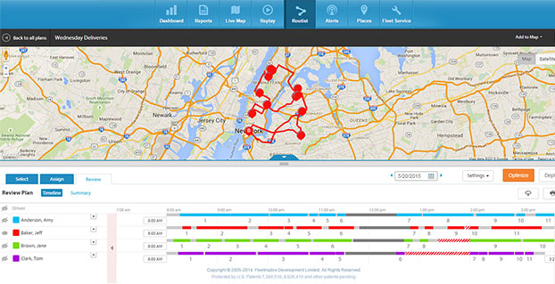
A new routing program from Fleetmatics Group is coming this summer. Fleetmatics Routist is an intelligent routing optimization solution that systematically builds the most cost-effective, customer-friendly routes for fleets.
Fleetmatics Routist seamlessly calculates and deploys route plans to drivers in the field, and features real-time and historical data that gives users the most holistic view into routing performance, the company said.
Fleetmatics Routist operates by taking locations, vehicles, time windows, technician skills, and costs and capacities into consideration, among other inputs, while remaining simple and intuitive for customers to use. Fleetmatics Routist also incorporates historical traffic data into its algorithm, elevating traffic and routing optimization effectiveness for customers operating in metropolitan areas.
“Inefficient routing wastes minutes, miles and money, leaving on-time arrivals and important elements of customer satisfaction to chance,” said Jill Ward, president and chief operating officer of Fleetmatics. “Customers that choose Fleetmatics Routist won’t have to worry about manual or time-consuming routing, and we fully expect the benefits will extend to their customers, as well.”
Fleetmatics Routist’s robust feature set, offered to customers as an add-on module, will integrate into the Fleetmatics REVEAL fleet management solution, helping it to become one of the most effective routing optimization solutions known to be available today. Customers can import work orders from electronic files or integration with their order management software, select the drivers involved in the plan, and get a cost efficient and customer satisfying route, Fleetmatics said.
Route planners can make adjustments to the plan based on their own business insight, and then deploy to the field. Route plans can be delivered effortlessly to drivers via the Fleetmatics REVEAL Field Application for smartphone and mobile devices, via Garmin integrated devices or simple route sheets printed at the office.
Once the routes are live, dispatchers and managers stay current on a driver’s progress against route stops in real-time on the Fleetmatics REVEAL live map and can make real-time adjustments as needed. When the day is done, actual versus plan analysis is available to compare the stops made by drivers against the work orders provided, so managers can provide appropriate coaching around route deviations and the impact of field activity on customer satisfaction.
Register here to receive additional information and notice of Fleetmatics Routist’s availability.
The Robotics in Action drone flying area at the AUVSI show.
The AUVSI show in Atlanta, held May 4-7, drew significantly more attention from TV media this year, as several of the major networks provided live coverage from the show floor. NBC’s Today morning show opened with a live shot of a drone hovering in front of an opening house door, as if patiently waiting to deliver a package from Google or Amazon — the potential good side of drones for consumers.
Then their coverage recalled the DJI drone crashing onto the White House front lawn in the early morning hours (perhaps an unfortunate loss of user control, but an odd time and place to be out flying a drone), and airline pilot reports of lighted drones appearing above nighttime final approach paths — the bad side of drones in common usage.
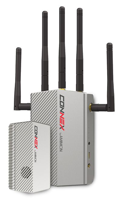
The Connex wireless system.
Then Brian Wynne, president and CEO of AUVSI, provided a positive insight on the latest forecasts of UAV’s contributing $82 billion to the U.S. economy. Wynne’s estimates included the generation of more than 100,000 new high-paying technical jobs within 10 years’ time. But in an effort to urge faster progress towards regulations, Wynne also suggested that for every day of delay in Federal Aviation Administration (FAA) rulemaking to allow open use of drones, the U.S. loses $27 million daily in economic impact.
There was similar encouraging coverage by Fox News from the Atlanta Convention Center show floor, followed by Brian Wynne again pitching for rapid introduction of commercial drone use in the U.S. Fox chose to broadcast from the Robotics in Action drone flying area, and to feature real-time, zero latency HD video transmitted via Amimon’s Connex wireless system. A good demo over live TV, and Amimon’s chance to tell the world about its wireless transmission system that can transmit HD video over up to half-a-mile away with zero latency — good news, incidentally, for Fox, NBC, CNN and other news gatherers.
This year, it also seems that the terminology battle with the U.S. media over the common usage of the term drone or drones, rather than the more accurate UAV or UAV, has been conceded. So now we can talk about drones no matter how much it pains us to do so.
But the FAA is not standing still. Well over 200 Section 333 exemptions have now been granted to allow commercial UAS applications to undertake or investigate revenue-generating business. FAA representatives came to the show to let people know they are working hard to progress towards the safe use of drones in U.S. airspace. Through a media-only press-conference, the FAA announced the B4UFly smartphone app to inform recreational drone operators if it’s safe to fly. Features include:
A clear “status” indicator that immediately informs operators about their current or planned location.
Information on the parameters that drive the status indicator.
A “Planner Mode” for future flights in different locations.
Informative, interactive maps with filtering options.
Contact information for nearby airports.
Links to other FAA UAS resources and regulatory information.
The app will access the user’s location to automatically generate this information. There is also a planning mode for what data could be available for a potential future location to which you may be preparing to go.
But the main news from FAA Administrator Michael Huerta at the press conference was about the Pathfinder program, which involves three U.S. companies undertaking research with the FAA to expand unmanned aircraft operations in the United States. Each project has a key element where boundaries are being stretched to gain experience and to develop new capabilities to overcome restrictions for UAVs.
CNN (Cable News Network) will use visual line-of-sight (LOS) drone newsgathering in urban areas. There have previously been heavy restrictions in most of the Section 333 exemptions on operating in populated areas. So, it would seem that care will be taken in how news coverage will be generated around and over people, but the news will still be working to get the live overhead video we are now seeing more often on TV.
PrecisionHawk and BNSF Railway will investigate operations in rural areas, flying outside LOS. This is big news, as most UAV operators want to extend their areas of operation much further than visual LOS. In particular, Amazon has been most critical about LOS restrictions — the retailer wants package delivery to be virtually automated. But more on that later.
Beyond visual LOS, investigations in largely unpopulated areas by PrecisionHawk and BNSF could result in safe technology and procedures that could be commonly used in populated area for other operators. This is clearly the FAA’s desire, and of course, its intent is also to deflect earlier criticism of lack of progress in this area.
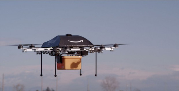
Onto Amazon. The company filed a UAV delivery patent with the U.S. Patent Office, where drone deliveries would be navigated by pulling location data from a customer’s smartphone — and real-time routes and directions would be constantly updated to guide the delivery process.
Amazon’s Prime Air “Delivery Drone.”
Amazon smart aircraft could interact between each other, passing on traffic and weather conditions. Delivery options for the consumer include a tool to deliver packages to your home, workplace or even to vacation locations.
Various safety precautions and caveats appear to have been appropriately addressed in the patent. Use of a number of sensors, including, radars, acoustic sensors and an infrared camera, are outlined in the patent to ensure safe navigation and landing. The patent also proposes a number of different types of unmanned aircraft with different shapes and weight for its delivery system.
And then on Tuesday, May 12, just after the AUVSI convention had wound down and left Atlanta, two U.S. senators jointly proposed a new bill that could expedite the commercial introduction of drones.
The senators believe the U.S. is falling behind other countries when it comes to creating rules for commercial drones. Sen. Cory Booker (D-N.J.) and Sen. John Hoeven (R-N.D.) introduced the Commercial UAS Modernization Act, which would set temporary rules for those who want to fly commercial unmanned aircraft systems before the FAA establishes permanent laws regarding drone use.
Sen. Corey Booker
The Commercial UAS Modernization Act outlines basic rules for commercial use around registration, certification, insurance, tests and safety. Operators would be required to keep the drones under 500 feet, fly only in daylight, and operate within visual line of sight (LOS). However, the proposal also creates a deputy administrator position that would be able to make an exemption for a commercial drone operator for beyond visual LOS and for “heavier unmanned vehicles.”
“Not later than 90 days after the date of the enactment of this Act, the Deputy Associate Administrator, in consultation with the Administrator, shall expedite and expand exemptions from the interim operating restrictions otherwise applicable to unmanned aircraft under section 337,” the act reads.
Sen. John Hoeven
When I talked with Sen. Hoeven this week, he emphasized that this bill seeks to accelerate the commercial use of drones in the U.S. and to make more use of the UAV test centers that the FAA has set up. These centers are capable of doing more, and can be the points that prospective drone operators visit to register their craft and take knowledge and proficiency qualification tests.
The bill gives tight timescales to the FAA to set up accessible locations to achieve registration and set up these operator qualification programs. In addition, the bill establishes a new deputy administrator position responsible for the safe integration of UAS in U.S. airspace, while also streamlining regulations that currently slow the industry’s ability to innovate new aircraft technologies.
In essence, the bill takes the core elements of the FAA’s past Section 333 approvals — less the requirement for a private pilot’s license — and makes them law. Operators would no longer need to ask the FAA for an exemption.
I asked Sen. Hoeven if the FAA has responded to the proposed bill, and he said he would be meeting with FAA Administrator Michael Huerta on May 14. “This follows their rules,” the senator said, so his message is let’s move forward together.
So, it would seem that momentum is at last gathering to overcome what would seem to be a lengthy period of FAA intransigence, including new innovative efforts by the agency itself to find ways to move forward more rapidly. Innovation in UAV technology, products and applications has been going on at a rapid pace, and the pent-up demand seems to be spilling over.
With more than 4,000 comments in hand for the FAA to deal with on its proposed rulemaking for small UAVs, it’s doubtful we’ll have any FAA regulations any time soon. So the Section 333 exemptions will probably continue, unless they are not totally overwhelmed by the new rules proposed by Senators Hoeven and Booker, who hope to see their bill approved sometime this year.
The coming leap second on June 30 sounds as scary as the (turns out not-so-scary) Y2K bug. But the world has experienced leap second issues before, and most affected industries are taking steps to prepare.
The world’s clocks will be adjusted by one second on June 30, when a leap second will be inserted into Coordinated Universal Time (UTC), the standard international time scale. In theory, all UTC clocks should insert a second labeled 23h 59m 60s (the leap second) following one labeled 23h 59m 59s UTC. This is equivalent to having all of the clocks in the world stop for one second at that time, as explained in May’s Expert Advice column.
A problem with some GPS receivers implementing the extra second caused the U.S. Civil GPS Service Interface Committee (CGSIC) to issue a notice in February. But GPS receivers aren’t the only thing that could be affected.
The Wall Street Journal is reporting that financial regulators and market participants are worried enough about the leap second that they’re planning for potential disruptions. The adjustment could present technical difficulties for traders and exchanges, as some computers might not be programmed to account for the adjustment, according to a Dow Jones report.
“These guys are agonizing over it,” Steve Allen, a programmer-analyst at the University of California’s Lick Observatory, told Dow Jones. “It is definitely a hassle.”
A U.S. Commodity Futures Trading Commission spokeswoman said that “For the most part, we’re not too worried,” told Dow Jones. “But of course as the regulator, we do need to ensure folks are ready.”
The last leap second occurred on June 30, 2012, and that leap second caused technical problems for websites and computing systems — including Reddit, Mozilla, Gawker, FourSquare, Yelp and LinkedIn.
Google had prepared ahead of time and was unaffected. Google gradually adds a couple of milliseconds to its servers’ clocks throughout the day when a leap second is to occur. According to a 2011 Google blog, “We modified our internal NTP servers to gradually add a couple of milliseconds to every update, varying over a time window before the moment when the leap second actually happens. This meant that when it became time to add an extra second at midnight, our clocks had already taken this into account, by skewing the time over the course of the day.”
But many web services didn’t follow Google’s lead in 2012 and experienced disruptions. Qantas‘ computer system went down for hours, forcing employees to check in passengers by hand. For background on the 2012 event, and a good explanation on the reason for a leap second, read “Time to Get in Sync” by Richard Langley, GPS World Innovation editor.
Amazon Web Services said it plans to “implement alternative solutions to avoid the ‘:60’ leap second. This means that AWS clocks will be slightly different from the standard civil time for a short period of time.”
In the U.S., stock exchanges such as the New York Stock Exchange and Nasdaq are working around the leap-second time (8 p.m. in the U.S.) by closing its after-hours trading a half-hour early, which is scheduled for 8 p.m.
The Hong Kong Observatory is advising stakeholders and operators in information technology, telecommunication, transport, and finance to review whether systems under their management can handle leap seconds properly, and if necessary, consider testing and adjusting their systems to ensure normal operation during and after the introduction of the leap second.
Time and frequency company EndRun Technologies is offering leap-second information on its website, and Cisco is offering its customers guidance on how to deal with it.
Racelogic, who make the LabSat simulator, will be recording the Leap Second as it happens and will then have the scenarios available for customers to replay. A variety of recordings will be taken: GPS, GLONASS, and BeiDou constellations will each be captured as a single channel, and also as a simultaneous triple-constellation recording. These will then be available to use with the LabSat.
Spatial Wave Inc. has released Field Mapplet Version 8.0 and Mapplet 8.0, which support ArcGIS 10.2 and 10.3.
Field Mapplet is a mobile solution for managing utility assets. It is designed to optimize utility workflows with features that are easy to use and implement, Spatial Wave said. The latest release includes enhancements in the mobile and console client, additional features to USA and Redline Extensions and Mapplet Manager, and support for Windows Server 2012R2, SQL Server 2014, and HTTPS secure service. A crucial upgrade of FM8.0 is that is supports ArcGIS 10.2 and 10.3.
With the core Field Mapplet framework, users can upgrade from FM Version 7.1 to 8.0 with minimal effort and downtime. FMv8.0 was built for day-to-day operations such as dispatching, navigation, routing, access to as-builts, engineering drawings, and redlining of location aware data. FMv8.0 is a configurable platform for building mobile applications such as customer requests, work orders and field data collections. FMv8.0 is touch-gesture-enabled and can be used on PCs, laptops and tablets.
Mapplet 8.0 is an advanced GIS viewer for viewing utility operational data and has unique capabilities to link to external data sources such as related engineering documents or tabular data. Users from an organization can gain access to business-critical data from the entire enterprise, including Customer Service, Field Operations, Engineering and Finance. The latest features include map tips, cluster symbology and heat maps. Mappletv8.0 supports ArcGIS 10.2 and 10.3 to enhance the user experience.
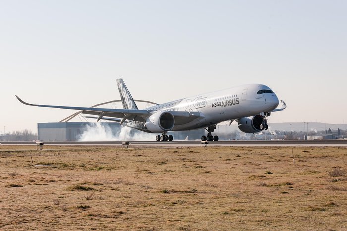
The twin-engine, wide-body Airbus A350 XWB, seen here at Spain’s Adolfo Suárez Madrid-Barajas airport, comes with EGNOS capability.
News by the European Space Agency
The EGNOS system, developed by the European Space Agency (ESA) for sharpening the accuracy of satnav across Europe, has been adopted by a growing number of airports to enable satellite-guided landing approaches. The new Airbus A350 airliner, currently entering service, comes fitted with it as standard.
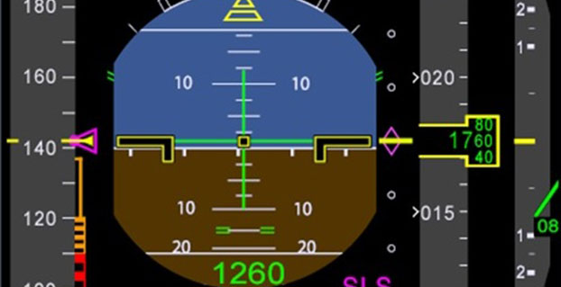
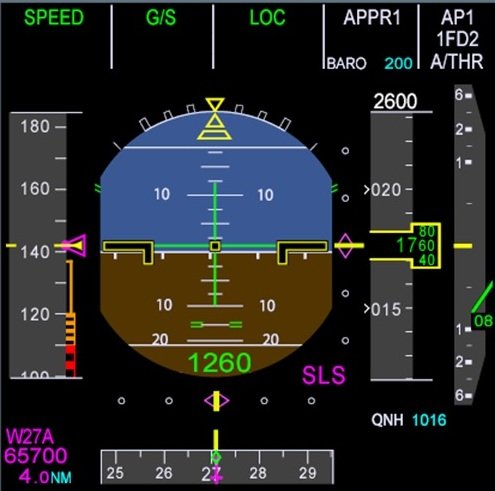
“For the first time on the A350 we have a new system called the Satellite Landing System,” explained Jean-Francois Bousquie, an Airbus flight-test engineer focused on avionics. “This allows pilots to perform precision landing approaches guided by EGNOS or its U.S. equivalent, WAAS, offering vertical guidance down to a minimum of 60 meters before the pilot sights the ground to make the go/no-go decision on the final landing descent.”
The A350’s Satellite Landing System allows pilots to perform precision-landing approaches guided by EGNOS or its U.S. equivalent, WAAS. The capability offers vertical landing guidance down to a minimum of 60 miles before the pilot sights the ground to make the go/no-go decision on the final landing descent.
The European Geostationary Navigation Overlay System, or EGNOS, can provide horizontal and vertical guidance to anywhere in Europe, without the need for any additional airport-hosted infrastructure. By using three geostationary satellites and a 40-strong network of ground stations, EGNOS improves the accuracy of GPS signals over European territory, while also providing continuous updates on their integrity.
The result is that the EGNOS-augmented signals are guaranteed to meet the extremely high performance standards set out by the International Civil Aviation Organisation standard, adapted for Europe by Eurocontrol, the European Organisation for the Safety of Air Navigation. The signals from space can therefore be relied on routinely for the safety-critical task of vertically guiding aircraft during landing approaches.
A total of 131 airports in Europe offer some 225 EGNOS-based approach procedures. By 2020, 582 landing procedures are expected across 20 European countries. The largest international airports use Instrument Landing System (ILS) infrastructure, with radio beams offering a truly precision landing capability, including the ability to autoland when visibility is at its worst.
But ILS is expensive to install and maintain, so smaller regional airports often forego it. The same is true of many new or expanding airports. Even with larger airports, in many cases only their busiest runways are equipped with ILS. So EGNOS offers a cost-effective way of safely increasing use of remaining runways, boosting the flexibility of any given airport.
“By reducing the value of the minima — the lowest safely guided altitude — for non-ILS runways, EGNOS increases the efficiency and safety of aircraft landings,” added Bousquie. “The take-up of EGNOS by European airports remains relatively low for now, but this should change over time. And with the A350, we are really designing for the long term — each aircraft will have a working life of 25 to 30 years.”
“Every qualified commercial airline pilot has been trained on ILS, to follow its radio beam,” Bousquie said. “So the Satellite Landing System works by having them follow the same type of cues as much as possible on a ILS ‘look-alike’ basis, employing all available navigation data including EGNOS.”
A pair of onboard Multi Mode Receivers manage the A350’s radio sensors, compute the deviations and ensure interface with display and guidance systems.
The deadline for abstract submission has been extended from May 15 to May 21. Since 2007, the worldwide scientific community has met every two years to discuss the scientific possibilities of Galileo and other Global Navigation Satellite Systems (GNSS).
This colloquium will bring together members of the European scientific community and their international partners involved in the use of GNSS signals in their research, specifically Galileo signals. Major academic players will meet with institutional and industrial executives to share innovative ideas and influence the future evolution of Europe’s own GNSS.
The colloquium focuses on four major areas of research:
Scientific applications in meteorology, geodesy, geophysics, space physics, oceanography, land surface and ecosystem studies, using either direct or reflected signals, differential measurements, phase measurements, radio occultation measurements, using receivers placed on the ground, in aircraft or on satellites.
Scientific developments in physics, dealing with future GNSS, particularly in testing fundamental laws in astronomy and in quantum communication. Relativistic reference frames and relativistic positioning will be addressed — also taking into account the scientific opportunities in tracking the first two Galileo Full Operational Capability satellites in their elliptical orbits.
Aspects of metrology such as reference frames, onboard and ground clocks, and precise orbit determination.
Scientific aspects of satellite navigation and positioning such as signal propagation, tropospheric and ionospheric corrections and the means to model and mitigate multipaths and interference.
The various possibilities to use navigation satellites such as Galileo for scientific purposes will be reviewed, and the contribution of scientific applications to making the most of the present systems and defining their evolution will be scrutinized.
For those interested in submitting papers, online submission of abstracts opens May 15 through the colloquium website, where other details of the event can also be found.
Apple has acquired Coherent Navigation, according to various media reports.
Coherent Navigation is a Bay Area GPS firm founded in 2008 by engineers from Stanford and Cornell. One of its areas of focus was high-integrity GPS (iGPS), an enhanced version of GPS that uses both normal, high-altitude GPS satellites and lower-altitude voice and data satellites from Iridium to increase the accuracy of a consumer’s GPS reading from the ground.
The acquisition seems to be Apple’s latest efforts to bolster its mapping capabilities.