Blog

  • Geodetics Teams with Velodyne for Real-Time Mobile Mapping Systems

    Geodetics-SolPark-W

    Geodetics Inc. has teamed up with Silicon Valley’s Velodyne Lidar. Velodyne and Geodetics will work on a variety of initiatives to enhance each others technologies and products with the goal of offering a small-size integrated inertial navigation and LiDAR-based mobile mapping payload for UAVs and other autonomous platforms.

    Payloads will include Velodyne’s HDL-64E, HDL-32E and VLP-16 real-time LiDAR systems combined with Geodetics’ Geo-iNAV inertial navigation systems.

    Geodetics and Velodyne are exhibiting this week at AUVSI’s Unmanned Systems Show in Atlanta, being held May 4-7 (booth 1500J and booth 2838 respectively). See our show coverage page for more information.

    Velodyne’s LiDAR sensors are the highest performance LiDAR systems on the market in their size, weight and power class. Geo-iNAV is a fully-integrated GPS-aided inertial navigation system that provides real-time, high-precision positioning and navigation for manned and unmanned air, sea and ground vehicles. It combines GPS and proprietary sensor fusion technologies to achieve centimeter-level real-time positioning and navigation for dynamic platforms.

    “We’re delighted to work with Geodetics to ease the integration process for our customers,” said David Oroshnik, Technical Sales Engineer, Velodyne LiDAR. “Our decision to support Geodetics is based upon the growing demand for cost-effective, small-sized, fully-integrated mobile mapping payloads that deliver performance traditionally associated with higher-end systems.”

    “Velodyne’s LiDAR systems enable Geodetics’ products to reach new markets and customers by delivering high performance in a smaller package and for a lower cost than competing devices,” said Lydia Bock, Geodetics president and CEO.

    With recent advances in unmanned vehicle technologies, the GNSS ecosystem has expanded to support such mission-critical applications as mobile mapping. These applications increasingly require more accurate navigation to accomplish their mission. The Geo-iNAV family of inertial navigation products delivers this capability with features that support reliable and precise navigation with a low SWaP (size, weight and power) profile for autonomous vehicles and payloads on manned vehicles.

    Geo-iNAV is offered in several configurations designed to meet a wide range of requirements. It is available in commercial as well as SAASM configurations, meeting a wide range of inertial navigation application requirements.

  • Hemisphere GNSS Releases Next-Generation GNSS RTK Engine

    Hemisphere GNSS has released Athena, its next-generation GNSS engine. Offering significantly enhanced performance, Athena provides Hemisphere with a new, future-oriented foundation providing strong performance, flexibility and reliability, according to the company.

    Athena has yielded outstanding performed in virtually every environment where high-accuracy GNSS receivers can be used, the company stated. Hemisphere customers have tested Athena’s performance in long baseline, in open-sky environments, under heavy canopy, and in geographic locations experiencing significant scintillation.

    Hemisphere has designed its new core engine to maximize the company’s ability to excel at the rigorous GNSS requirements in multiple market segments, supplying its customers in machine control, survey and GIS, with a design for now and in the future, Hemisphere said in a statement.

    The release of Athena is a significant milestone for Hemisphere, which promises another new product entry into the market in the coming months.

    Features of Athena include these capabilities:

    • Initialization time — A reliably consistent initialization performance, less than 15 seconds at better than 99.9 percent reliability.
    • Robustness in difficult operating environments — Extremely high productivity under the most aggressive of geographic and landscape oriented environments for GNSS, while delivering up to 50 percent better performance in user tests matched against competitive systems.
    • Performance on long baselines — Position stability for long baseline applications, with position quality often times exceeding the performance of other leading RTK systems on the market.
    • Performance under scintillation — Sustained accuracy under ionospheric scintillation activities, providing one of the most reliable means to work with GNSS in scintillation-affected areas.

    Rodrigo Leandro, Hemisphere’s director of engineering, GNSS Positioning Systems, gave this description of the design process for Athena.

    “Development of Athena started shortly after I came to Hemisphere in August of 2013. The company has been a leader in RTK solutions for many years. During those years, we focused in certain specific market segments such as agriculture, and under new leadership we determined there was a need to address a wider spectrum of market segments, with very high accuracy and feature rich capabilities built on the strong legacy platform we had already established. So, working with Mike Whitehead, the company CTO and our main RTK technologist, we identified the goal of reengineering our RTK engine to match the needs of RTK for the next 10 years, and to provide a foundation for future product development.”

    Leandro continued, “As part of this, we made a decision to build an expanded, world-class software development team, pulling great talent from around the industry to create a group of 11 totally focused on what we should do to move GNSS technologies forward — looking at all types of positioning techniques, not just RTK. Athena is just the first result of that work to become publicly available — you will see plenty more coming from the team over time.

    “Looking at Athena specifically, we did a complete review, touching every part of the engine — from how we deal with the atmosphere, quality-control of the data, modeling the clock of the receiver, and so on, through to how to do external corrections, whether single-based or network-based. We even looked at and modified the receiver system, improving the multitasking architecture to more actively use the CPU for our computational work,” Leandro said.

    I’m proud to say that the results of all that work match up to what we envisioned. RTK is a pretty mature technology at this point, so improving on what is available in the industry is a tough ask. However, our extensive competitive testing shows that the engine performs really well in terms of initialization, accuracy, and stability across a range of different environments, for instance in long baselines and under tree canopy, and our tests of scintillation are showing great results as well. Overall, we have seen excellent accuracy coming out of this engine compared to legacy as well as others in the marketplace. It’s hard to win every single time in a toe-to-toe comparison, as systems and conditions differ in every test, but our broad testing shows us not only matching, but beating competitive systems pretty consistently.”
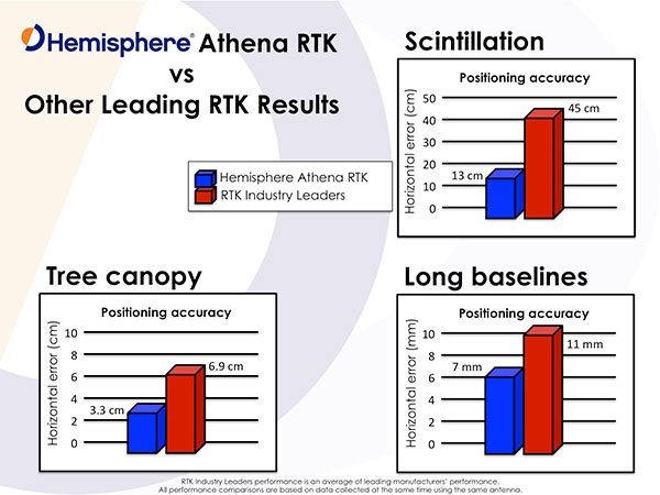
    Photo: Hemisphere GNSS

    “In our user base, both Hemisphere branded products and our OEM boards, we get exposed to a wide variety of applications and environments, from agriculture and marine, through machine control applications and survey systems,” Leandro said. “Our goal from the start was to build a system that performed across that user base, and we are proud to say that we have delivered with Athena.”

    “In terms of availability, we want to get the Athena engine on as many current and legacy systems as possible, so our users have the best possible experience. However, we have also been improving the legacy engine as well, delivering gradual steps of improvement to our customers, so whatever version they are using, their experience should be much improved,” Leandro concluded.

    Test Reports

    Hemisphere GNSS provided the following statements by an independent tester and from customers, widely distributed around the industry.

    “I’ve had an opportunity to thoroughly test Athena in both moderate and extreme environments,” said Andy Carbognin, an independent GNSS test specialist at Vecto Geomatics of Ottowa, Canada. “I’m very impressed with the performance, and we’ve tested alongside the current industry leaders’ top-of-the-line products. In every situation, Athena is proving to be a tremendous improvement over Hemisphere’s most widespread legacy firmware versions, at a minimum, matching the industry’s best while in many cases exceeding their performance.”

    “Carlson Software has extensively tested Hemisphere’s new Athena RTK engine on the Carlson BRx5 GNSS receiver,” said Butch Herter, director of Hardware Development, Carlson Software. “The Athena RTK engine provides precise, reliable, and repeatable positions. Athena exceeds or matches the performance of all other GNSS receivers it has been tested against. We have been particularly impressed with the performance of the Athena engine, when using a long baseline or in areas where there is a limited view of the sky. Athena is a first class RTK engine.”

    “We’ve been working with Hemisphere’s technology for a number of years,” states Randy Noland, vice president of business development and director of Machine Control, Carlson Software. “I’m amazed at the team they’ve brought together and how they’re radically modernizing their technology. Collaborating with the ‘new’ Hemisphere has been an eye-opening experience, and I’m excited at how their innovative technologies will positively impact our future business.”

    “In the marine construction and hydrographic survey markets, time is money. We’ve seen very high system reliability and impeccable results using the Athena RTK engine, which ensures we are achieving maximum up-time,” said Harrison Steves, operations manager at Cable Arm. “As well, not being tied to a specific make of RTK base gives us flexibility with our equipment deployment.”

    “We’ve found Athena to offer exceptional performance, especially their RTK fix times and maintaining RTK lock on long baselines,” said David Vaughn, CEO, Novariant. “With the latest competitive performance testing completed, Novariant is excited about adding Hemisphere’s Athena offering to the list of the Novariant-recognized certified receivers that, when combined with our precision steering solution, can assure centimeter-level steering control in the toughest environments in the world.”

    CEO Statement

    “Our goal is to be nothing short of the best GNSS technology partner in the industry, and a key component of that is delivering market-leading technologies tailored to our customer’s needs,” said Chuck Joseph, Hemisphere GNSS CEO and president. “To that end, we have put together a world-class team that is totally rethinking our product family, and our new Athena engine is just the first, powerful proof of our fresh approach. Watch this space!”

    Availability

    Before the end of this month, Athena will be included in all Hemisphere multi-frequency, RTK-capable products, such as the A325, R330, S320 and VS330. To download and install Athena, visit Hemisphere’s Software page.

  • TerraGo Edge: Every Soldier a Data User and Data Collector

    For years, when I was the GIS manager for the Atlanta Regional Commission (ARC), I’d get an annual visit from the Layton Graphics sales rep trying to sell me something. Layton Graphics was an Atlanta blueprint company. I never needed blueprint services so I politely listened and sent the sales rep on his way. In 2005 that changed when the sale rep demonstrated his company’s eye-opener GeoPDF, a significant leap in GIS-enabled map publishing. With the invention of the GeoPDF, the company was reformed as TerraGo, and the rest, shall we say, is history.

    Screenshot of Edge on an iPhone showing data capture points in red and current location in blue.
    Screenshot of Edge on an iPhone showing data capture points in red and current location in blue.

    Until GeoPDFs, we published our GIS data as Shapefiles on CDs and relied on users to display the data correctly using their own GIS software. Since many new GIS users had no cartographic training the resultant maps frequently looked terrible or, even worse, completely misrepresented the data. As the publishers of the raw data, we frequently got blamed for some very crappy-looking maps- including those created by our own ARC transportation and land-use planners. GeoPDFs changed that since the cartography remained intact. Not until Esri’s Map Publisher, now ArcGIS Publisher, and subsequent cartographic tools was cartography preserved as the originator intended.

    A GeoPDF was a single Adobe document that bundled GIS data, imagery and resultant maps into one compact file with no lost data files, no improperly displayed data and no incorrect data pointers. The Acrobat file was, in effect, an interactive GIS map display that permitted a user to pan, zoom, turn layers on and off, view, import social media and navigate 3D models and many other functions in one single compact file. GeoPDFs proved so valuable that they became the Army’s and other federal agencies’ geospatial publication method of choice.

    The Next Geospatial Leap

    Recently, TerraGo made another geospatial technology leap, doing for geospatial data collection what the company did for geospatial data display. TerraGo streamlined and sped up geospatial data collection with its new product, TerraGo Edge. TerraGo Edge is a cloud-based application that works on PCs, tablets and even smartphones. A user downloads the app and can then build a data-collection environment that is completely tailored to the needs of an organization. Field personnel can then rapidly collect enterprise data using a PC, tablet or smartphone with very little training and no additional software. The application permits the collection of tabular data, photographs, video clips and more that are georeferenced using the mobile device’s built-in GPS to locate each data point. All data is saved in the cloud and instantly shareable with designated users.

    Now the even better news: If the network connection is lost or weak, the field collection can continue in the disconnected environment. The collected data is stored locally, then automatically synced when the connection is restored. The simplicity of the system and disconnected use may help make the Army’s Future Combat Systems vision, in which each soldier is a data user and data collector, a cost-effective reality.

    Field Test

    Bryan Burns of TerraGo collects data with his iPhone and Bluetooth-connected Bad Elf GPS.
    Bryan Burns of TerraGo collects data with his iPhone and Bluetooth-connected Bad Elf GPS.

    I had to see the system in actual operation, so I paid a visit to the TerraGo Atlanta offices last week. Scott Lee and Bryan Burns of TerraGo gave me a full demo. I previously loaded the TerraGo trial app on my iPhone, which you can also do by going to your app store and downloading the free trial application. The software is fairly intuitive, and I was able to shoot a georeferenced picture and record some notes on my own. Bryan and Scott demonstrated the more advanced Edge features, especially the creation of custom collection forms that greatly speed data collection by field users.

    Form creation is an important aspect of Edge, because it not only speeds data collection, it also reduces the chance of errors. As most of you know, sloppy data capture can really corrupt a database. Poor spelling, missed keystrokes, etc., can make database searches difficult and even result in missed records. Developers have found that entry errors can be minimized and collection speed enhanced with several simple data collection tools and techniques that are part of TerraGo Edge. Some of these include the use of pull-down menus for frequently used terms, numeric/alphanumeric entry key restrictions, checkboxes, the use of “radio buttons” for multiple choices, and others. As a result, field users can collect data as quickly as they can walk from one location to another with minimal data entry errors or corruption.

    How Much Does It Cost?

    $360 per year, with up to three devices. If you want TerraGo to host your operation, storing and backing up your data, that’s another $360 per year. The only additional cost, assuming you already have a smartphone, is additional GPS hardware to achieve better accuracy than the native 5 meters of a smartphone. The additional hardware cost depends on your accuracy needs. A Bad Elf plug-in device gives you 2-meter accuracy for $300 and 1-meter accuracy for $600. Better is a sub-meter accuracy iSX Blue II for $2,000, and even an RTK centimeter system, the EOS Arrow 200, for $6,000. This graph shows the hardware comparisons.

    Keep in mind that the GPS units permit data collection even if disconnected, and all available GPS metadata is captured with each fix, so additional post-processing could be done at a later date if needed. The system also comes with a ton of GeoPDF maps, vector data such as OpenStreetMap, WMS feeds and imagery to serve as a backdrop for your data collection. As you would expect, the data you collect can be saved and exported in popular formats such as Esri Shapefiles, KML and GeoPackage, the new OGC handheld standard being supported by AGC and NGA.

    How Good Is It?

    This image shows the water fountain in front of the TerraGo offices.  The green dots show the data points I captured with the Bad Elf Bluetooth GPS.
    This image shows the water fountain in front of the TerraGo offices. The green dots show the data points I captured with the Bad Elf Bluetooth GPS.

    We then went outside for a short data-collection test using the Bad Elf Bluetooth GPS. It was easy to pair the Bad Elf to my iPhone, and I was able to collect data as fast as I could walk from one location to another.  Since this was a short test in the open, I couldn’t judge how quick data collection would be in less than ideal conditions such as building canyons or tree canopy cover. I’d certainly want to spend a day collecting under different conditions to get an accurate feel for the speed, accuracy and reliability of each hardware option in a production environment.

    Go to the TerraGo website for a much deeper dive. Edge looks like it will give the competition a real run for the money, not to mention the very significant smartphone accuracy improvements being tested in the labs. So, in short, you can have in your hand a networked GPS datalogger with up to cm accuracy that can operate in a disconnected environment. It seems like smartphones are slowly replacing our stand-alone devices — watches, media players, digital/video cameras, car navigation, compass, level, PC and flashlight. I can even use my iPhone as a magnetometer. Now, even high-end GPS dataloggers are in the smartphone crosshairs.

    A good way to see TerraGo Edge in action will be the GPS World webinar at 1300 EDT May 28. Registration is free.

    P.S. With Mother’s Day and Memorial Day coming up soon, I’d like to call your attention to my column last year. We frequently read about the bravery and hardships of our military, but the families at home not so much. The mother in the column was so selfless I can’t forget her. You won’t either.

  • Sky-Watch Partners with General Dynamics on UAVs for Defense

    Sky-Watch Partners with General Dynamics on UAVs for Defense

    Artist's concept of the proposed Airborne Swarm Protection Shield by GDELS and Sky-Watch.
    Artist’s concept of the proposed Airborne Swarm Protection Shield over a GDELS armored vehicle (image courtesy of Sky-Watch).

    General Dynamics European Land Systems (GDELS) has signed a Memorandum of Interest (MOI) with Danish UAV company Sky-Watch in Støvring, which allows the two companies to explore potential areas of cooperation within next-generation applications of UAV technology in the battlefield.

    “Sky-Watch is constantly striving to be at the forefront of the rapidly developing UAV technology,” said Michael Messerschmidt, Sky-Watch chief business development officer. “We offer our vast accumulated know-how within sensor fusion to our partners, in the pursuit of finding new ways to solve tomorrow’s challenges. We constantly rethink and redefine the value proposition, of our own as well as our partners’ ideas and concepts and I believe that we can identify some very exiting avenues of cooperation with General Dynamics European Land Systems.”

    Sky-Watch offers the Huginn X1 multi-purpose Quadrotor UAV deployed all over the world and is developing the Muninn X1, a next-generation fixed-Wing VTOL UAV. The future of UAVs in the battlefield will be explored by Sky-Watch Labs, the research and development arm of Sky-Watch, in cooperation with partners such as the Technical University of Denmark on a variety of projects.

    With regard to the acquisition of new Armored Personnel Carriers (APC) for the Danish Army, General Dynamics European Land Systems is prepared to take its partnerships with Danish industry to the next level and explore business in adjacent markets like the one of Sky-Watch. GDELS has signed Industry Cooperation agreements with 40 Danish companies of all sizes across the country, and has already defined projects in excess of 3,7  billion  kroner covering all of the technology areas defined in the Danish Government’s Defence industry strategy.

    “Throughout the past 20 years, GDELS Industry Cooperation program has been one of the catalysts for the development of the Danish defence industry. We have executed projects of almost 1,7 billion kroner with the industry, which has helped to contribute to the development of new products and technologies in a variety of companies. By engaging with an innovative and creative company such as Sky-Watch, we help plant the seed for the future of the Danish defence industry,” said Jens Bauer, GDELS Senior Director International Business & Services, responsible for Industrial Participation.

    GDELS’s Industry Cooperation plan for the APC program is based on 20 years of experience and partnership with Danish industry. The program expands relationships beyond production and sustainment contracts to also include research & development projects, which will lay the foundation for growth in the Danish Defence industry for decades to come.

  • Mapping the Nation’s First Mothers for Mother’s Day

    FirstMothers-Esri-W

    Forty-four women gave birth to the most influential men in U.S. history — presidents. This Mother’s Day, Esri highlights these “First Mothers” in an interactive story map.

    Navigating the Story Map uncovers interesting facts, such as:

    ·        At 18 years old, Stanley Ann Obama became the youngest First Mother.

    ·        The seven presidents born in Ohio were Republican.

    ·        Presidents John Adams and John Quincy Adams were born .2 miles apart.

    View the story map here.


  • FAA Pathfinder Initiative Opens Door for Industry UAS Use

    The U.S. Department of Transportation’s Federal Aviation Administration (FAA) today announced a partnership with industry to explore the next steps in unmanned aircraft operations beyond the type of operations the agency proposed in the draft small unmanned aircraft systems (UAS) rule it published in February.

    “Government has some the best and brightest minds in aviation, but we can’t operate in a vacuum,” said U.S. Transportation Secretary Anthony Foxx. “This is a big job, and we’ll get to our goal of safe, widespread UAS integration more quickly by leveraging the resources and expertise of the industry.”

    FAA Administrator Michael Huerta announced the initiative today at the Association for Unmanned Vehicle Systems International Unmanned Systems 2015 conference in Atlanta, Ga. See more coverage of the show from Geospatial Solutons.

    The FAA is working with industry partners on three focus areas, including:

    • Visual line-of-sight operations in urban areas: CNN will look at how UAS might be safely used for newsgathering in populated areas.
    • Extended visual line-of-sight operations in rural areas: This concept involves UAS flights outside the pilot’s direct vision. UAS manufacturer PrecisionHawk will explore how this might allow greater UAS use for crop monitoring in precision agriculture operations.
    • Beyond visual line-of-sight in rural/isolated areas: BNSF Railroad will explore command-and-control challenges of using UAS to inspect rail system infrastructure.

    “Even as we pursue our current rulemaking effort for small unmanned aircraft, we must continue to actively look for future ways to expand non-recreational UAS uses,” Huerta said. “This new initiative involving three leading U.S. companies will help us anticipate and address the needs of the evolving UAS industry.”

    The three companies reached out to the FAA to work on research continuing to expand use of UAS in the nation’s airspace. CNN and the FAA already have been working together through a Cooperative Research and Development Agreement (CRDA). BNSF has a draft CRDA that is nearly complete and PrecisionHawk has been working with the FAA on a possible research partnership.

    Further developing these operational concepts supports the FAA’s overall strategy to expand UAS access, which currently includes rulemaking, reviewing operational data from the six national UAS test sites, expanding commercial operations via the Section 333 exemption process, and issuing operational authorizations for type-certified UAS.

    The FAA published a proposed rule for small UAS on February 23, 2015 and received nearly 4,500 public comments by the end of the comment period on April 24. The agency will work as quickly as possible, but must address all the comments submitted before finalizing the rule. The number and complexity of the comments will play a role in determining the timeline for a final rule.

    For more information on the FAA and UAS, go to http://www.faa.gov/about/initiatives/uas/.

  • Trimble’s New OEM Module Combines GNSS with MEMS Inertial

    Trimble’s New OEM Module Combines GNSS with MEMS Inertial

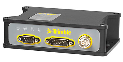
    Trimble BD935-INS module.
    Trimble BD935-INS module.

    Trimble has introduced the Trimble BD935-INS module that features precision GNSS with an integrated 3-D Micro-Electro-Mechanical Systems (MEMS) inertial sensor package. As part of Trimble’s GNSS OEM portfolio, the new compact module augments real-time precise positioning with 3-D orientation.

    The BD935-INS module’s simple connectivity and configuration capabilities allow system integrators and OEMs to easily add GNSS and attitude to specialized or custom hardware solutions, Trimble said in a news release.

    Trimble made the announcement at AUVSI’s Unmanned Systems 2015 Conference and Exhibition.

    “The OEM and system integrator communities demand high performance, reliability and support for their positioning solutions,” said Dale Hermann, general manager of Trimble’s Integrated Technologies Division. “The Trimble BD935-INS delivers the latest GNSS and inertial technology in an easy-to-integrate form factor for demanding conditions and applications such as lightweight robotic or unmanned vehicles. With the BD935-INS module, customers are purchasing a robust navigation solution, extending performance beyond that of a GNSS receiver only.”

    Taking advantage of Trimble’s expertise in both GNSS and inertial technologies, the Trimble BD935-INS module has been designed for applications requiring both RTK and orientation in a compact package. By integrating inertial sensors onto the GNSS module, users can experience more robust performance in a variety of challenging environments, Trimble said.

    The BD935-INS features triple frequency for both GPS and GLONASS constellations, as well as dual frequency for BeiDou and Galileo. The module delivers fast and reliable RTK initialization for 1–2 centimeter positioning. For applications that do not require centimeter accuracy, the BD935-INS integrated GNSS-inertial engine delivers high-accuracy GNSS and DGNSS positions in challenging environments such as urban canyons, tunnels, heavy canopy or other GNSS-denied environments, the company said.

    Trimble also announced the new BX935-INS, which is an environmentally rugged enclosure for OEM or system-level integration. The BX935-INS houses the Trimble BD935-INS module for easy installation and immediate access to high-rate position and attitude data for a variety of applications.

    The Trimble BD935-INS and BX935-INS is expected to be available in the third quarter of 2015 through Trimble’s Integrated Technologies Precision GNSS sales channel.

  • AUVSI Announces Rebrand of Annual Trade Show

    AUVSI Announces Rebrand of Annual Trade Show

    AUVSI-Xponential-show

    Annual Conference Renamed Xponential to Reflect Innovative and Expanding Industry  

    The Association for Unmanned Vehicle Systems International (AUVSI) today announced the rebranding and evolution of its premier global industry event for unmanned systems, drones and robotics, the AUVSI Unmanned Systems show, taking place this week in Atlanta, Ga. With nearly 600 exhibitors and 8,000 attendees, AUVSI’s event attracts leaders in all aspects of the industry, from manufacturers to end users.  

    GPS World is covering the AUVSI Unmanned Systems show this week from Atlanta. See our coverage here.

    “Xponential encapsulates the tremendous growth and innovation in the unmanned systems industry, as well as the broad societal benefits of the technology,” said Brian Wynne, president and CEO of AUVSI. “Xponential will help the world understand the potential of this industry by providing a single gathering place where people can see and interact with the technology and systems that will soon become part of our everyday lives.” 

    Xponential will continue to serve as the experience hub for business and investment for this $48 billion industry, AUVSI said. This technology is already being used by farmers, first responders and firefighters to help save time, save money and save lives.

    Over the next few weeks and months, AUVSI will be working to expand the event offerings to bring a new level of community to the growing industry it serves. Many of these new programs were launched this year, including advanced educational tracks and innovative experiences that bring together the industry’s leading experts and organizations.

    For more information visit www.xponential.org. 

  • Model Plane Fliers to Get Real-Time, Location-Based Flight Safety Info

    Model Plane Fliers to Get Real-Time, Location-Based Flight Safety Info

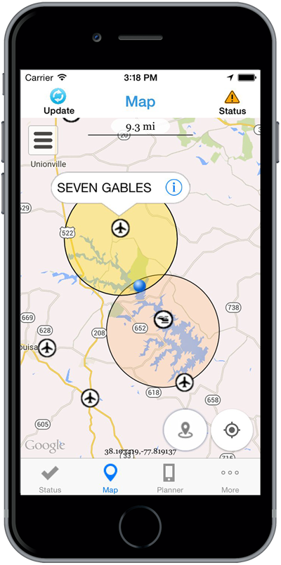
    Photo: B4UFLY iOS appToday’s second announcement of a new UAV-related initiative by the Federal Aviation Administration (FAA) was directed at private citizens: model airplane enthusiasts and hobbyists, also called modelers — not at industry or commercial use. See this story for information on the Pathfinder program for commercial drone use.

    A soon-to-be released smartphone app will proved users with real-time information on flight regulations, and restrictions for the user’s actual location; alternately, for a location to which the user is planning to travel to for a model plane flight. Named B4UFly, the app is designed to answer for users, “Is it safe and is it legal to fly my model aircraft based on where I am right now?” The overall goal is to encourage responsible use of model aircraft.

    The B4UFLY iOS app will be made available to 1,000 iPhone beta testers this summer. The first 700 emails received by [email protected] will make up the initial limited beta test group. The email is for model aircraft hobbyists only, who want to sign up for beta test. B4UFLY Version 1 for iOS will go out to the general public later this year. An Android app will come later.

    “Someone who got their first UAV as a gift probably does not know [the rules governing flight and airspace operation],” said Jim Williams, the manager of the FAA’s Unmanned Aircraft Integration office. “It’s a knowledge gap that is very very important that we fill. Hobbyists and modelers need to know that there are very real consequences if you don’t have that knowledge. The recent Incident on the White House lawn provides a perfect case in point.”  

    The app was developed in cooperation with the MITRE Corporation. Key features of the B4UFLY app include:

    • A clear “status” indicator that immediately informs operators about their current or planned location.
      Information on the parameters that drive the status indicator.
    • A “Planner Mode” for future flights in different locations.
    • Informative, interactive maps with filtering options.
    • Contact information for nearby airports.
    • Links to other FAA UAS resources and regulatory information.

    The FAA’s Know Before You Fly campaign launched just prior to Christmas last year was a preliminary step in this effort.

    Williams prefaced his remarks with, “These model planes and copters are ready to go, right out of the box.  I know, I have one.” He then guided press through a brief look a clips and demo of the app’s key features. The app will provide real-time access to rules, requirements and restrictions based on location, and suggests specific actions to take if the user is:

    • within five miles of an airport 
    • within a national park
    • within a restricted airspace (such as Washington, D.C.); and so.  

    The app will access the user’s location to automatically furnish this information. There is also a planning mode to see what data is available for a planned location to which you are preparing to go, although you are not there yet.

    “Unmanned aircraft should always yeild the right of way to manned aircraft,” Williams stressed. “This is not the be-all and end-all of when and where you can fly. It does not alleviate the user’s responsibility to operate safely.”

    In response to questions, FAA Administrator Michael Huerta clarified that the FAA currently issues flight restriction covering large public events, such as the Master’s golf tournament.

  • FAA, Industry Partners Launch Pathfinder Program to Define UAV Integration into Airspace

    FAA, Industry Partners Launch Pathfinder Program to Define UAV Integration into Airspace

    CNN will use Drone Aviation's tethered drones to gather footage in in urban areas from never-seen-before angles and heights. The company's WATT-200 was unveiled at the AUVSI this week.
    CNN will use Drone Aviation’s tethered drones to gather footage in in urban areas from never-seen-before angles and heights. The company’s WATT-200 was unveiled at the AUVSI this week.

    Federal Aviation Administration (FAA) Administrator Michael Huerta announced two new initiatives related to unmanned aircraft systems (UAS) today at the Association for Unmanned Vehicle Systems International (AUVSI) Unmanned Systems 2015 conference in Atlanta, Ga.

    Pathfinder, the first initiative, announced in the morning, is reported here. The second initiative is an app in development to enable drone hobbyists to fly their craft safety.

    Administrator Huerta told the large gathering of national journalists, “The unmanned aircraft industry is changing faster than any segment in the aircraft industry. A new project to harness that energy, the Pathfinder program, is partnering with three leading U.S. companies to expand unmanned aircraft operations in the United States.”

    Photo: Federal Aviation AdministrationThe FAA is working with industry partners on three focus areas:

    • CNN (Cable News Network) will research visual line of sight (LOS) operations for newsgathering in urban areas. CNN will continue working with Georgia Tech University to improve newsgathering for all organizations.
    • PrecisionHawk will investigate agricultural operations for rural areas, flying outside LOS.
    • BNSF Railway, second-largest freight railroad network in North America, will undertake inspection of rail infrastructure, also beyond visual LOS.

    Huerta said that the partners, collectively, “are trying to push the envelope, what can we accommodate, accommodate safely, and what can we learn from that.  We’ll test a little, learn a little, then test some more. How do we see a staged implementation? To integrate unmanned aircraft, but to do it safely, as directed by Congress.  We’re trying to push the edges of what we can allow, working with partners who have specific uses and resources that they will apply to those.”

    When asked for a timeframe to reach  new UAV regulations, he replied, “I can’t comment a lot on the rule itself, but it’s fair to say that in the rulemaking comment process [which closed on April 24], we received more than 4,500 comments. It’s too early to say how those comments will shape what the final rulemaking will take.  Assessment will be done in the coming months, perhaps by the end of the year, but that’s an aggressive timetable. This effort will go on as long as the partners want us to go on doing it.  That’s not accomplished in six months, nor should it take a million years.”

    As to LOS restrictions, and beyond LOS, he replied,  “The framework of the previously published rule was focused on LOS, and on the use of visual observers in addition to the operator.  Now we’re taking the next step, to explore beyond LOS uses. What are reasonable applications for that, and what mitigations for safety should be put in place for that? Everyone wants to get there. It’s important to figure out how we get there safely.”

    What mitigations will be put in place for beyond LOS? A vice president of BSNF Railway said that the company is “working with FAA and several vendors around command and control infrastructure. This is yet to be fully defined.  The railroad is a very safe an unforgiving environment.  This doesn’t replace anything we’re doing today, it’s an addition.” He defined the operating environment as ” a 300 or 400-mile capability, to fly looking for broken rail, etc., beyond the visual, on-the-ground inspections that rail crews already do. ” He anticiated the use of “sense-and-avoid technology [for the UAVs], not using chase planes but perhaps using communications capabilities from cell towers and railway infrastructure along the right of way.”

    The CEO of PrecisionHawk commented similarly, “We’re not changing much of our operational flow, just extending the baseline for it.  We will implement a traffic-management technology, called Lattice, leveraging to ensure safety and reliability beyond the operator’s LOS.”

    Gregory Agvent, CNN’s director of News Operations, said he looked forward to “some camera shots that were previously impossible for us, that now we’re going to be able to do.” Under the terms of the Certificate of Authorization (COA), Agvent said that “We’re capable of doing it [undertaking UAV missions] without asking for (FAA) permission” for specific flights. 

    The three industry participants concurred that they will work with their [UAV] partners in parallel with the rules to develop a certification process, so that the FAA can determine their vehicles are uniformly safe, the same way the y do with piloted aircraft currently. Both the railroad and PrecisionHawk have one currently operating flight platform each, and are looking at others, as theirs do not fit all applications.

    “These are not exclusive [agreements],” emphasized Huerta, “limited to particular platforms or applications. This is a practical research effort to apply, learn, and integrate on the broadest scale.” When asked about possible further participants in the Pathfinder project, Huerta indicated the three companies represented on the briefing platform with him: “They came to us.  You can interpret that as an invitation. We’re casting a very wide net. How do we et to a broader integration and implementation?  We need multiple ways to gather information.”

    Agvent urged, “It’s critical for manufacturers to come to the table, to get certified by make as opposed to individual models, to get free access to the sky.”

    Huerta concluded, “We are learning together, as an industry and as a regulator.  How can we collectively, as an industry, learn more in order to see a much more robust integration of unmanned aircraft into our aviation industry?  We’re all interested in pushing the boundaries, and sharing the information broadly across the industry.”

    The surprise preview of the pending announcement drew scores of curious and concerned industry representatives and exhibitors at the massive AUVSI show, who gathered anxiously outside the press briefing room, to which they were not admitted.

    “The FAA is moving ahead with safe integration of UAS into the busiest, most complex airspace in the world,” according to an FAA statement issued prior to the briefing.”Even as the agency proceeds with rulemaking for small UAS, it continues to look at new ways to foster safe UAS operations by both hobbyists and businesses.”

  • Welcome to AUVSI’s Unmanned Systems 2015

    The Association for Unmanned Vehicle Systems International’s (AUVSI’s) Unmanned Systems 2015 show, held May 4-7 in Atlanta, convenes the global community of commercial and defense leaders in intelligent robotics, drones and unmanned systems.

  • Avyon Offers Precision Mapping for Microdrones md4 Fleet from Applanix

    Avyon, a sUAS (Small Unmanned Aircraft Systems) integrator and distributor, is using the Applanix APX UAV for its md4 fleet, to provide users with cost-effective direct georeferencing technology.

    The integration of the Applanix APX-15 UAV on the md4-1000 and md4-3000 microdrones will offer solutions for unmanned aircraft while complying with weight and size restrictions for payloads. The APX-15 works seamlessly with all other airborne sensors such as digital cameras, LIDAR and other sensors, Avy0n said.

    The APX-15 on the md4-1000 microdrone is on display at booth 1803 at the AUVSI Unmanned Systems 2015 show, being held May 4-7 in Atlanta, Ga.

    “The integration of the APX-15 with md4-1000 and md4-3000 will provide users with a precision mapping capability, minimizing or eliminating the requirement for ground control points and making mapping missions more efficient,” said Mike Hogan, Avyon’s business development manager.

    The APX-15 UAV on the md4 fleet will improve aerial mapping by eliminating GCPs (ground control points) for triangulation, as well as reduce the amount of overlap in the surveying process. This will increase efficiency and effectiveness for area flown per mission and the post-mission data processing, Avyon said.

    “We recognize the need to provide the growing UAS mapping market with the same highly efficient solutions that we pioneered for airborne mapping over 15 years ago,” said Joe Hutton, director of Inertial Technology and Airborne Products at Applanix Corporation (xyHt pg. 14). “We are now offering a cost-effective solution that meets the size, weight, power and cost requirements of small UAS, and maintains the Applanix pedigree for quality and performance. We are pleased Avyon has partnered with us. The md4-1000 DMS-UAV is a powerful new solution.”