Kairos Autonomi produces solutions that can be retrofitted or “strapped-on” to any existing optionally unmanned vehicle or vessel.
Kairos Autonomi is displaying its latest autonomous technology designed for use with heavy equipment and machinery. Kairos’ robotic applique kits are add-on vehicle autonomy systems that provide unmanned capabilities to current manned vehicles, rendering them optionally unmanned.
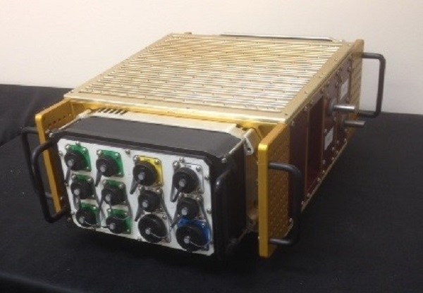
Equipped with larger gear faces, stronger actuators than its predecessors and a pathing upgrade, the Pronto4 Heavy delivers the increased torque needed to control the traction, braking, throttle and implements in heavy vehicles and equipment, as well as smarter robotic functions such as GPS path following and supervised autonomous behaviors.
The Pronto4 Heavy Planar Robotic Applique Kit For Heavy Equipment. (PRNewsFoto/Kairos Autonomi)
The robotic applique kit is platform independent, meaning it can be installed in any heavy vehicle or machine, rendering that vehicle optionally unmanned, which means the equipment can still operate manually as needed.
The Pronto4 Robotic Applique Kit manufactured by Kairos is used throughout the world to convert existing man-operable ground vehicles and surface vessels into unmanned systems. Applications include government or academic research and development; military training and test and evaluation; range clearance; mining; and tactical military applications.
Trimble is partnering with unmanned aircraft system (UAS) manufacturer Multirotor service-drone, GmbH. The collaboration will allow Trimble to expand its existing UAS portfolio to provide its customers with additional solutions to choose from based on their aerial imaging project needs.
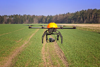
Multirotor service-drone, based in Germany, is a manufacturer of multi-rotor systems. Trimble will be Multirotor service-drone’s exclusive provider of multi-rotor vehicles for aerial mapping use in surveying, construction, mining, agriculture, oil and gas, and utilities. The combination of Multirotor service-drone’s stable and reliable platforms with Trimble’s industry-leading sensor technology and workflow efficiencies will provide customers with best-in-class solutions for aerial data capture.
Unmanned multi-rotor systems are powerful solutions for visually documenting smaller areas, vertical structures or environments where holding position is important. High-resolution imagery, orthophotos, terrain models and normalized difference vegetation index (NDVI) map deliverables created from multi-rotor data provide valuable information for the survey, engineering and agriculture industries that Trimble serves.
“We are very excited to partner with Multirotor service-drone. At Trimble we’re always looking for ways to meet our customer’s needs and enable them to solve the complex problems they encounter every day,” said Todd Steiner, product marketing director in Trimble’s Geospatial Division. “The collaboration will enable our customers to use a technology rapidly growing in popularity due to its flexibility and productivity.”
Swiss professional drone maker senseFly has launched the eXom, its new quadcopter UAS for mapping and inspection. The eXom is available to pre-order immediately and ships this summer.
The eXom is a sensor-rich system, sensefly said. Developed by experts working across numerous fields of robotics, this lightweight quadcopter offers professionals such as civil engineers and land surveyors the situational awareness, imaging flexibility and durability they need to complete challenging tasks safely, accurately and efficiently.
“We believe the eXom’s level of application-focused technology is unique in the civilian drone market,” said Antoine Beyeler, CTO and co-founder of senseFly. “This platform tightly integrates several one-of-a-kind features, such as TripleView imaging, advanced situational awareness and full flight mode flexibility — to provide inspection and mapping professionals with the functionality they desire from a rotary system.”
eXom is a future-ready platform with a quad-core computer onboard, senseFly said. Like senseFly’s fixed-wing drones, it offers users evolving performance through regular software updates, adding the latest drone tech innovations to keep the eXom at the cutting edge for years to come, the company said.
eXom’s low take-off weight of 1.7 kg (3.7 lb) ensures its users will, in many countries, have less flight authorization paperwork to deal with than those who use heavier systems.
The eXom’s advanced integrated sensors work together to provide the user with full situational awareness and support obstacle avoidance:
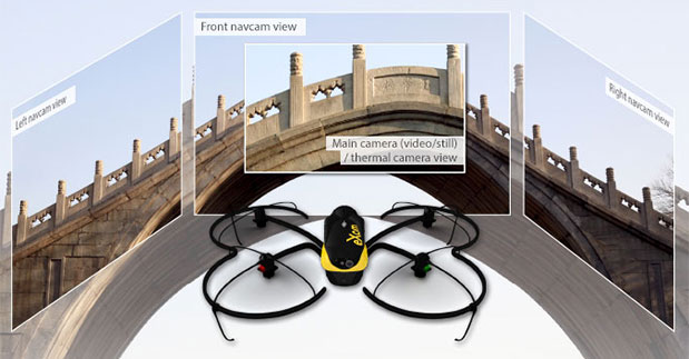
Five navcam vision sensors allow the operator to see in the direction the drone is moving, automatically via its flight control software, without needing to turn the system’s TripleView camera head. This technology is similar to the visual parking sensors in modern cars, but brought into a 3D flight environment.
Five ultrasonic proximity sensors work in harmony with eXom’s navcams to ensure the operator always knows the drone’s distance from nearby objects. (The drone’s shock-absorbent carbon fibre shrouding is also always on hand to protect its rotors in case of surface contact.)
Numerous other sensors, including inertial measurement units, barometers, magnetometers, GPS and magnetic encoders, maximize the drone’s stability and safety.
eXom’s autopilot-controlled TripleView camera head enables the user to view and record three different types of imagery during a single flight without needing to land to change cameras:
HD video
Ultra high-resolution stills
Thermal still/video
Because the TripleView head faces forwards, eXom can fly up close to target structures such as building walls and dams to achieve sub-millimeter data resolutions. Plus, with the head’s 270-degree vertical field of view, users can document objects positioned directly above and below the drone — crucial for tasks such as bridge and roof inspections.
eXom offers various flight modes:
Autonomous mode — for mapping projects. First, create a flight plan using eMotion X’s mission blocks. eXom then launches, flies, acquires geo-referenced imagery and lands itself.
Interactive ScreenFly mode — this streaming video mode is for live inspection tasks. Use the supplied joypad to navigate and orient the drone via computer screen. This mode includes flight assistance features such as cruise control and distance lock.
Create a flight plan, launch in autonomous mode, then go live on demand.
No matter which mode is activated, RC-based manual control always remains available as a backup function and for experienced pilots.
Visit senseFly at Unmanned Systems 2015: Hall B2, Booth 519. The eXom will be demonstrated in flight at the senseFly booth at at the show’s Air & Ground Demo Area (demo timings: May 6, 12:15 and 14:15, May 7, 11:45 and 14:15).
Drone Aviation Holding Corp., a developer of specialized lighter-than-air aerostats and tethered drones, today announced that its wholly owned subsidiary, Drone Aviation Corp. (DAC), has received an order from specialized defense contractor Troll Systems for a set of Winch Aerostat Small Platform (WASP) aerostat systems.
Under terms of the award, DAC and Troll will jointly form a working group to integrate the L-3 Wescam MX-10 advanced optical sensor system into the WASP platform for an international customer. The working group plans on commencing integration in May with initial flight testing expected to take place by Q3 2015.
Drone Aviation also announced that CNN is working with the company to explore how their tethered drone technology might be used in newsgathering operations in urban areas, as part of its FAA partnership, also announced at the AUVSI show. CNN selected Drone Aviation to leverage its WATT-200 tethered drones to gather footage from never-seen-before angles and heights. WATT-200 was unveiled at the AUVSI this week.
DAC develops and manufactures the WATT Electric Tethered Drone, Blimp in a Box (BiB) and WASP aerostat product lines. The WATT Tethered Drone, as well as the BiB and WASP aerostats, utilize a secure, high strength tether line that remains connected to the ground for safe and reliable operations.
DAC’s systems are intended to provide semi-persistent, mobile intelligence, surveillance, and reconnaissance (“ISR”) and extended communications for various applications. Each system can provide low cost, mobile ISR and mobile communications for days, weeks or months. BiB and WASP aerostats are currently in use in a number of U.S. Department of Defense (DoD) applications as well as at State and Local Police and Departments of Transportation where they provide silent, cost effective day and night monitoring and mobile communications.
Drone Aviation is exhibiting this week at AUVSI Unmanned Systems 2015 in Atlanta.
DoD-owned WASP systems are currently participating in sponsored exercises and are part of future capability studies as part of the DoD’s evaluation of the WASP as a highly mobile, tactical aerostat for ISR and communications. The DoD-owned WASP systems have successfully completed operations in a series of the United States Army Network Integration Experiments (NIEs) and have been recognized by the Army as a tactical battlefield solution that can support soldiers on the ground.
“Drone Aviation is pleased to partner with Troll Systems to expand the capabilities of our WASP platform and to help them meet the stringent requirements of their overseas customers,” said Felicia Hess, CEO of Drone Aviation Holding Corp. “With the addition of the L-3 Wescam MX-10 optical package, we are greatly expanding the operational capabilities of the WASP tethered aerostat system, further demonstrating the platform’s ability to flexibly deliver simple, secure and cost effective tactical surveillance and communications to customers.”
Exelis has improved the way its CorvusEye 1500 wide-area airborne system processes and analyzes the vast amount of data it collects, which is crucial in helping customers make critical decisions, the company said.
CorvusEye 1500 is one of the programs Exelis is featuring at Association for Unmanned Vehicle Systems International’s (AUVSI’s) Unmanned Systems 2015 May 4-8 in Atlanta (booth #2449). From an altitude of 15,000 feet, CorvusEye 1500 provides color and infrared imagery of a city-sized area unavailable with comparable airborne systems. At Unmanned Systems 2015, visitors will see how users work with the real-time analytics and processed data to search for vehicle tracks based on location and time.
“It’s all about context,” said Dwight Greenlee, director, regional persistent surveillance, Exelis Geospatial Systems. “Conventional video surveillance systems with their ‘soda straw’ views can miss critical activities, making it hard to understand what’s happening over a wide area. CorvusEye now has real-time analytics that automate certain tasks. For example, users can set ‘watch boxes’ or ‘trip wires’ in as many as 10 areas of interest. Users are then alerted if anything moves in or out of that area, and they can automatically track that moving object. Because of the context provided by CorvusEye, users can be more confident in the data to make decisions.”
Another new capability in CorvusEye is the ability to cue a second sensor, such as a hyperspectral sensor, to scan a location for certain spectral “signatures” indicating the presence of a material or gas. Analysts also can easily integrate full-motion video sensors into the cueing capability.
Processing CorvusEye data post-flight provides analysts with a database of all moving objects in the entire scene, allowing them to gather critical forensic intelligence and enabling a better understanding of behaviors and patterns across the region.
At 15 inches in diameter and weighing less than 95 pounds, the CorvusEye turret and sensor package can fit on most midsize unmanned and manned aircraft and uses standard interfaces to swap into virtually any 15-inch airframe mounting location. CorvusEye is exportable to many military, intelligence and security customers around the world, Exelis said.
With Exelis RangeVue, a high-performance GIS visualization engine provides real-time updates of critical operational elements.
Exelis has signed agreements with four Federal Aviation Administration (FAA)-designated unmanned aircraft systems (UAS) test sites for airspace situational awareness and research. The research will focus on using the Exelis Symphony RangeVue sense-and-avoid tool towards safe integration of unmanned aircraft into the national airspace system.
Under the terms of the agreements, the test sites will gain valuable real-time and historical situational awareness of the range airspace via Symphony RangeVue, while Exelis gains critical product feedback through operational usage. Participating test sites are:
Pan-Pacific UAS Test Range at University of Alaska, Fairbanks
Northern Plains UAS Test Site at University of North Dakota
Northeast UAS Airspace Integration Research Alliance at Griffiss International Airport, N.Y.
Mid-Atlantic Aviation Partnership at Virginia Polytechnic Institute
“The partnerships with these test sites are win-win arrangements,” said Ed Sayadian, vice president of Civil & Aerospace Systems for Exelis. “The test sites receive air traffic control quality surveillance data, increasing safety and enabling beyond-line-of-site operations, while Exelis gains critical product feedback, which will be used to shape and validate our service offerings.”
Symphony RangeVue enables UAS operators and test range personnel to have access to both real-time and historical aircraft surveillance information via a web-hosted platform, helping to manage mission operations across multiple locations.
Symphony RangeVue can be used as command center decision support and post-event analysis tool, or in the field as a sense-and-avoid addition to UAS ground control stations. Flexible geo-fencing tools alert operators when a UAS approaches airspace boundaries or other aircraft are in the vicinity.
Additionally, Exelis is pursuing research and development opportunities with the test sites exploring detect-and-avoid algorithms; non-cooperative target tracking; command and control systems; infrastructure inspection and monitoring; big data analysis for air traffic; and integration of non-FAA surveillance sources. Exelis will leverage capabilities across multiple test sites for a wide range of operational testing and collection of safety data.
The next version (0.93) of the “gfzrnx” RINEX-2/3 Tool is now available. Because of user feedback, the developers have fixed bugs and have added these new features:
strict epoch interval handling via -sei command line parameter
support of the upcoming RINEX version 3.03 (BDS B1 obs. types, IRNSS support)
The software is still in a beta state, according to the GFZ IGS Analysis team. Any feedback (such as suggestions or bugs) is welcome and can be sent to [email protected].
The United States will reach one million unmanned aircraft systems (UAS) flights per day within the next 20 years, given the right regulatory environment, according to new economic research from the Consumer Electronics Association.
Brian Markwalter, senior vice president, market research and standards, CEA, shared the association’s domestic UAS economic analysis at the Unmanned Systems 2015 Conference in Atlanta, Ga.
“This is a billion-dollar technology market literally just waiting to take off,” Markwalter said. “We see a dynamic market with tremendous growth potential, once we have final Federal Aviation Administration (FAA) rules to allow commercial UAS operation, combined with continued industry and FAA cooperation to achieve low-risk, beyond-line-of-sight flights.”
“With the right regulatory environment, drones will be safely integrated into our transportation system — displacing noisy trucks, reducing urban traffic, cutting our fuel consumption and carbon emissions,” said Gary Shapiro, president and CEO, CEA. “This will allow for game-changing innovations such as the quick delivery of life-saving diagnostics and medicine, improvements in crop production and efficiency, and safer work environments for those who inspect and maintain our buildings and bridges.”
According to the CEA research, the U.S. UAS market is indeed growing, but risks falling behind in the global market because of fewer or more progressive regulations in other countries. In fact, as the U.S. awaits further FAA rules regarding the commercial use of UAS, CEA’s research estimates a pent-up market demand of $150-$200 million in UAS sales for “line of sight” operations.
Only hobbyists and the do-it-yourself community now are allowed to fly UAS in the U.S., enough to fuel a robust U.S. consumer market with the potential to reach $250 million by 2018. However, if the FAA remains on track to complete its line-of-sight rules for commercial operators within three years, CEA’s research foresees another $200 million in growth. Additionally, with the continued development of “sense and avoid” technology and FAA rules that foster “beyond-line-of-sight” operations, the United States’ UAS industry could become a $1 billion market.
“The ability for beyond-line-of-sight is the true game changer—opening the door to autonomous UAS operation and unleashing a remarkable economic potential,” said Markwalter. “The United States has a long history of being a technology leader—and we’ve led the world at almost every stage of flight innovation. But we have more work to do on UAS. Realizing these economic gains will require ongoing FAA and industry cooperation, as well as a commitment to the necessary infrastructure.”
CEA market research expects 2015 to be a defining year for unmanned systems, with the category ideally positioned for steady growth. According to CEA projections, the global market for consumer UAS will approach $130 million in revenue in 2015, increasing by more than 50 percent from 2014; with unit sales of consumer UAS expected to approach 425,000, an increase of 65 percent.
“Right now, more than six billion packages are delivered every year in the U.S., weighing less than three pounds apiece on average — perfect candidates for drone delivery,” said Markwalter. “The autonomous operation of UAS for the delivery of everyday items would not only lower the cost for consumers and improve delivery times, but also be a significant driver of our tech economy.”
This year CEA debuted the Unmanned Systems Marketplace at the 2015 International CES, with 15 UAS companies — almost four times as many as last year — covering 7,600 square feet of exhibit space. At CES, Shapiro announced CEA’s support of the UAS safety campaign “Know Before You Fly,” which provides prospective UAS operators with the information and guidance they need to fly safely and responsibly.
The gvSIG project team is asking for the gvSIG community to help test and debug version 2.2 as soon as possible so the final version can be released. The gvSIG team encourages users to test the software and send them any errors and suggestions in the users mailing list.
The main new features of this version are:
New editing extension, including new functionalities
Labeling by scale
Legend by scale
Hyperlink to folders
OGC services publishing
Seismic formats
Sailing symbols library
The development team says the new version represents a marked change from the previous version, and therefore may have still-unidentified errors. A new manual has also been developed.
Trimble has announced a series of new software enhancements that enable photogrammetry, GIS, geospatial and remote sensing professionals to streamline workflows, achieve faster results and gain increased value from highly accurate geospatial data. Enhancements include the Trimble Inpho version 6.1 photogrammetric suite, UASMaster version 6.1 and UASMaster Lite for Unmanned Aircraft System (UAS) applications, and eCognition version 9.1 and eCognition Essentials version 1.1 image analysis software.
The announcement was made at the Imaging and Geospatial Technology Forum (IGTF), formerly ASPRS, held May 4-8 in Tampa, Fla.
“Optimizing software workflows for our customers to gain value from imaging data is critical for the success of geospatial professionals and a continued focus of Trimble Geospatial,” said Alain Samaha, business area director of GIS and Geospatial Software Solutions for Trimble’s Geospatial Division. “The new enhancements will enable customers to streamline processes and increase their efficiency and productivity, which translates to increased cost savings and decreased operational expenditures.”
Photogrammetry professionals generating high-quality deliverables, with Trimble’s Inpho software, such as 3D CAD line work, GIS layers and DTMs, can now reduce production time by days through optimized geo-referencing capabilities and new tools for CAD object creation. The Inpho version 6.1 enhancement allows snapping-to-elevation and draping lines-to-elevation models—for greater efficiency in creating CAD data layers—while maintaining the highest level of accuracy.
The UASMaster version 6.1 software enhancement offers greater productivity through new support for precise GNSS data that allows users to reduce the number of ground control points required without compromising accuracy. For professionals new to the UAS market, UASMaster is now also available in an entry-level “Lite” edition. The new UASMaster Lite edition allows users to quickly extract high quality deliverables within a simplified workflow, while obtaining the same industry-leading quality offered with Inpho software.
Inpho version 6.1 and UASMaster version 6.1 now also include a direct interface connection to Trimble’s eCognition analysis software, making it easier to obtain actionable and valuable information from imagery data in land classification maps, GIS layers and change analysis.
eCognition version 9.1, an object-based image analysis software, now includes enhanced multi-core processing, allowing GIS, geospatial and remote sensing professionals to extract valuable information from satellite and aerial based data faster than before. New GIS-based analytic tools and improved tools for packaging applications make it easier to create customer solutions.
eCognition Essentials version 1.1 provides up to 50-percent faster processing than previously, including improved flexibility and control of classification workflows for professionals generating land-cover mapping deliverables.
NavCom’s StarFire Network is a global satellite-based augmentation system (GSBAS) that provides five centimeter positioning accuracy on a worldwide basis. (more…)
Editor’s Note: This month, we introduce a column by David Doyle, one of our two new survey editors. Doyle brings to GPS World more than 40 years of experience as a geodesist and surveyor with the National Geodetic Survey — see his full bio at the end of this article. He will be joined by coeditor Dave Zilkoski, who will contribute the June column.
David Doyle
Since the mid-1980s, thousands of articles have appeared in peer reviewed journals, trade magazines and professional organization publications that describe the phenomenal capabilities of contemporary space-based positioning systems. The majority have been about various uses of the United States Global Positioning System (GPS) and increasingly include the potential for the inclusion of the Russian GLONASS, European Union Galileo and China’s BeiDou collectively referenced as Global Navigation Satellite Systems (GNSS).
Without meaning to understate the process, the ability for almost anyone, anywhere, at any time to determine a three-dimension position accurate to within a few centimeters is well established. I often comment that the systems are generally so easy to use that if you have the IQ of a squirrel you can obtain pretty good quality data. A feat that until recently was achievable only by the small community of geodesists and geodetic surveyors is now a near-trivial process for anybody who can make a modest investment in some form of positioning system device — and it’s getting better, faster, cheaper and more accurate all the time.
Our ability to collect, manage and display monumental amounts of positional data is also enhanced by the advances in Geographic Information Systems (GIS).
I have been privileged to be a part of this revolution since my initiation into the world of geodetic positioning in 1967, courtesy of the Selective Service System and the U.S. Army, and their use of geodetic triangulation combined with emerging artificial satellite systems such as SECOR (Sequential Collation of Range). These introductions to geodesy eventually led me to a position with the National Geodetic Survey and a career that spanned 40+ years.
During that time, we watched as the centuries-old method of triangulation was replaced by GPS, and as the prices of equipment plummeted with the integration of this technology into a multitude of public, private and academic disciplines — everything from geophysical sciences to weather prediction, precision agriculture, improved marine and aeronautical navigation. The list goes on and on and is well known to those who read this magazine.
So where is this going? What does the title of this article mean?
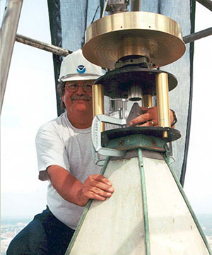
Doyle working on the Washington Monument.
If we accept, which we do, that all these things are true, then why is it that the world of sharing positional information is filled with scenarios that go something like this? “I got a cm and you got a cm, but our centimeters differ by a meter.” What this means is if these systems are so capable, then virtually all positional data integration should be a snap — everything should fit like a bespoke shirt. Unfortunately, that is often just not so.
Take the case of a decree issued by the U.S. Supreme Court in December 2014 delineating the offshore boundary between the United States and the state of California. The boundary is defined as a set of Universal Transverse Mercator (UTM) grid coordinates published to the nearest mm and referenced simultaneously to the North American Datum of 1983 (NAD 83) and the World Geodetic System 1984 (WGS 84), which the decree states are interchangeable. At the mm level, this is not true. In this area, they differ by approximately 1 m.
The decree provided no information on how these positions were derived, how accurate they really are, and who performed the computations — it certainly was not the Supreme Court. Without pointing fingers at the responsible agency, these all-too-common occurrences seems to be rampant among the many users of high-accuracy positional data, both horizontal and vertical. The crime is often the sin of omission.
The failure in many cases is a lack of knowledge on the part of many GNSS users of some of the basic principles of geodesy and geodetic surveying guidelines and providing complete metadata such as:
what geodetic datums and potentially which realization of those datums were referenced?
what are the units of measure?
how accurate are the positions/heights really?
It’s important to note that the number of digits to the right of a decimal point have nothing to do with accuracy. Land surveyors are taught from their first day on the job that they are following in the footsteps of the surveyor that went before them. It is not unusual for surveyors to struggle with incomplete information from previous surveys to be able to make accurate interpretations of what the original or other previous surveyors intended — a lack of complete metadata.
Today, the massive amount of coordinate and height information being generated by thousands of surveyors, engineers and other disciplines are those footsteps — albeit digital. The multitudes of high-quality data being collected around the world is only as good as the associated information about those values.
As we rapidly approach a time when there will be vastly improved GNSS constellations and very likely cm-level positioning available to millions if not billions of people in cheap handheld devices, the issues of professional education and attention to detail are more important than they have ever been. While it would be really nice if everyone who picked up a GNSS receiver had an advanced degree in geodesy, obviously that is not only unrealistic, it’s senseless. What does need to happen is a comment that I’ve made in hundreds of seminars on these topics — those in professions and disciplines where high-accuracy coordinates are important should know enough to qualify for the Junior Geodesist Secret Decoder Ring!
There are efforts in the works at this time that may bring us a step closer to making this a reality. The American Association for Geodetic Surveying (AAGS) is working on a geodetic surveying certification initiative in collaboration with the National Society of Professional Surveyors (NSPS). This effort will be aimed at anyone who is inclined to collect, manage, distribute and/or utilize the increasing amounts of high-quality positional information.
Watch this space for more details next time.
David Doyle joined the National Geodetic Survey in 1972, and held the position of chief geodetic surveyor for 12 years before his retirement in January 2013. He was responsible for the development, technical design and management of plans and programs that enhanced the United States National Spatial Reference System. During his career with NGS, his experiences included all phases of geodetic triangulation, astronomic positioning, leveling, GPS data collection, data analysis, datum transformations, network adjustments, data publication and outreach in the form of seminars, workshops and webinars. His efforts also included extensive activities to direct and coordinate the modernization of national geodetic reference frames in countries in Africa, Central, Caribbean and South America, Eastern Europe and the Pacific.
Doyle is a past president of the American Association for Geodetic Surveying and a Fellow member of the American Congress on Surveying and Mapping. He has served on the U.S. delegation to the International Federation of Surveyors and is an active member of the District of Columbia, Maryland and Virginia professional surveyors associations. Doyle now operates Base 9 Geodetic Consulting Services.