NavCom Technology’s Jim Williams explains the precise positioning and navigation solutions offered by the company for UAS (unmanned aerial systems) at Unmanned Systems 2015, held May 4-7 in Atlanta. It offers GNSS aerial antennas, RTK positioning and its StarFire global satellite-based augmentation system (GSBAS).
Blog
-
Trimble Details New OEM Module at Unmanned Systems 2015
Akshay Bandiwdekar of Trimble Integrated Technologies details the company’s BD935-INS module that features precision GNSS with an integrated 3-D Micro-Electro-Mechanical Systems (MEMS) inertial sensor package at Unmanned Systems 2015, held May 4-7 in Atlanta. As part of Trimble’s GNSS OEM portfolio, the new compact module augments real-time precise positioning with 3-D orientation.
-
NovAtel Showcases FlexPak6, FlexPak-S Receivers
At Unmanned Systems 2015, held May 4-7 in Atlanta, NovAtel’s Peter Soar talks about the company’s FlexPak6 receiver that houses its OEM628 triple-frequency plus L-Band GNSS receiver board. It has a highly configurable interface to ensure precise positioning for UAV (unmanned aerial vehicle) applications. Soar explains that its “sister unit,” the FlexPak-S, contains a real time kinematic (RTK) GPS receiver with an L-3 XFACTOR Selective Availability Anti Spoofing Module (SAASM). The two receivers are both the same size and fit.
-
NovAtel Talks GPS Anti-Jam Technology for Use in UAVs
NovAtel’s Peter Soar shares on the company’s GAJT (“Gadget”), a single unit GPS anti-jam antenna for use in UAVs (unmanned aerial vehicles). GAJT nullifies jammers, ensuring satellite signals necessary to compute position and time are always available.
GAJT may integrate into unmanned vehicle platforms or can be retrofitted with GPS receivers and vehicle navigation systems on military fleets.
-
Spirent Federal Systems GSS9000 GPS/GNSS Constellation Simulator
Jeff Martin of Spirent Federal Systems talks about how its GSS9000 simulator can help with unmanned aircraft system (UAS) development while at Unmanned Systems 2015, held May 4-7 in Atlanta. The GSS9000 simulator supports multi-system, multi-constellation GNSS testing for UAS.
-
Racelogic Highlights GNSS Simulator, VBOX Speed Sensor IMU
Jim Lau of Racelogic details the company’s GNSS Simulator and VBOX Speed Sensor IMU while at Unmanned Systems 2015, held May 4-7 in Atlanta. VOBX is a 100Hz dual antenna GPS/GLONASS speed sensor (VBSSISL) that combines signals from an integrated inertial measurement unit (IMU) with those from GPS to provide smoother output data even when satellite reception is interrupted.
-
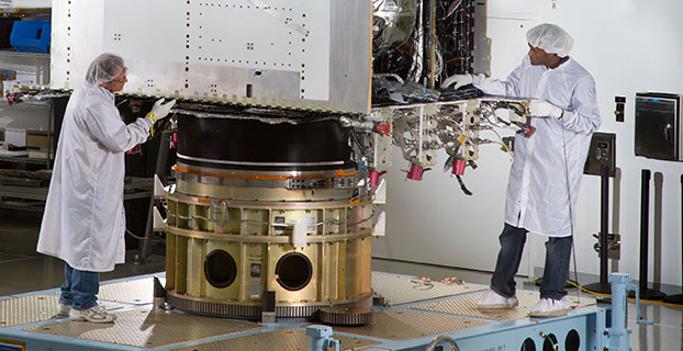
First GPS III Satellite Ready for Harsh Environment Testing
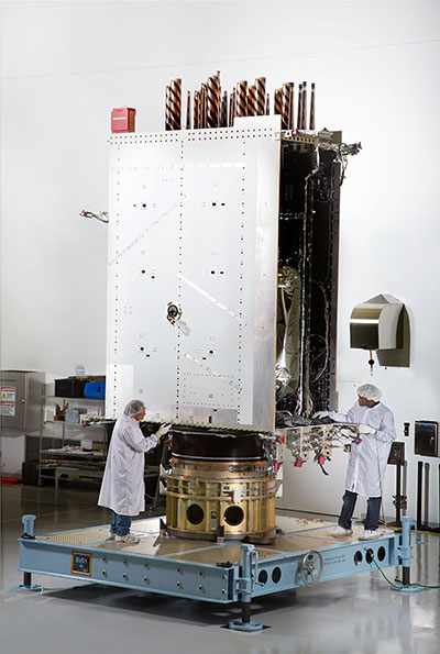
First Photo a GPS III Satellite: In April, Lockheed Martin fully integrated the U.S. Air Force’s first next-generation GPS III satellite. GPS III Space Vehicle One is now preparing for system-level testing this summer. Using a 10-ton crane, Lockheed Martin engineers and technicians gently lowered the system module of the U.S. Air Force’s first next generation GPS III satellite into place over its propulsion core, successfully integrating the two into one space vehicle.
The April systems integration event brought together several major fully functional satellite components. The system module includes the navigation payload, which performs the primary positioning, navigation and timing mission. The functional bus contains sophisticated electronics that manage all satellite operations. The propulsion core allows the satellite to maneuver for operations on orbit.
“The final integration of the first GPS III satellite is a major milestone for the GPS III program,” said Mark Stewart, vice president of Lockheed Martin’s Navigation Systems mission area. “This summer, SV 01 will begin Thermal Vacuum testing, where it will be subjected to simulated harsh space environments. Successful completion of this testing is critical as it will help validate our design and manufacturing processes for all follow-on GPS III satellites.”
Lockheed Martin is under contract to build eight GPS III satellites at its GPS III Processing Facility near Denver, a factory specifically designed to streamline satellite production.
GPS III space vehicle one (SV 01) is the first of a new, advanced GPS satellite design block for the Air Force. GPS III will deliver three times better accuracy, provide up to eight times improved anti-jamming capabilities, and extend spacecraft life to 15 years — 25 percent longer than the satellites launching today. GPS III’s new L1C civil signal also will make it the first GPS satellite interoperable with other international global navigation satellite systems.
The GPS III team is led by the Global Positioning Systems Directorate at the U.S. Air Force Space and Missile Systems Center. Air Force Space Command’s 2nd Space Operations Squadron (2SOPS), based at Schriever Air Force Base, Colorado, manages and operates the GPS constellation for both civil and military users.
-
Septentrio Launches UAS Receiver, Software for Drone Market
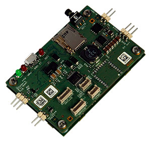
The AsteRx-m UAS by Septentrio. Septentrio has launched the AsteRx-m UAS, an RTK-accurate GNSS receiver solution specially designed for the drone market. The AsteRx-m UAS provides high-accuracy GNSS positioning with low power consumption, according to Septentrio.
The launch of the AsteRx-m UAS board is complemented by the release of GeoTagZ software suite. The GeoTagZ suite works with the UAS camera and image-processing solution to provide centimeter-accurate position tagging of images without the need for a real-time data link.
The AsteRx-m UAS will be on display at booth #635 during AUVSI’s Unmanned Systems 2015, held May 4-7 at the Georgia World Congress Center in Atlanta.
Despite being Septentrio’s smallest receiver, the AsteRx-m UAS provides consistent, robust and accurate positioning from to Septentrio’s in house GNSS+ algorithm technology. The receiver delivers cm-level accuracy at less than 600 mW with GPS and less than 700 mW with GLONASS. LOCK+ technology guarantees tracking under heavy usage and IONO+ guarantees no interference in challenging ionospheric conditions, Septentrio said.
Integration into Any UAS. One of the key characteristics of AsteRx-m UAS and GeoTagZ is the seamless integration into any UAS. AsteRx-m UAS features standard connection functionality that directly connects to a UAS autopilot, such as Pixhawk and Ardupilot. The power comes directly from a number of power sources, including micro USB, a 9-30V external power supply or the vehicle power bus. GeoTagZ is available as a library of software to integrate into an UAS image-processing tool chain.
“We want to make UAS-based data collection and processing extremely simple. AsteRx-m UAS and GeoTagZ do just that,” said Jan Leyssens, commercial product manager at Septentrio. “The GNSS board connects seamlessly to standard hardware and cameras used on a drone. Together with our software, we provide a data collection solution that provides cm-level accuracy without the need for ground control points or real-time data links, and that integrates effortlessly with an existing UAS image processing software solutions.”
-
IFEN’s v3.0 of SX3 GNSS Software Receiver Adds Functions
IFEN has launched the latest software release, v3.0, for its SX3 GNSS Software Receiver Generation.
The newly released software version 3.0 offers the following new features:
- Real‐time P‐code generator and P‐code aiding for GPS L1/L2 cross‐correlation
- Full dual‐antenna support for SX3 Black Edition
- KML file output for Google Earth real‐time visualization
- better performance through switch from 32-bit to 64-bit version
- support of new SX3 RF front‐end with up to 12 IF streams
IFEN’s SX3 multi‐GNSS software receiver now tracks all known and in future upcoming GNSS signals in view in real‐time on a standard laptop (up to 1,000 channels in parallel on a core i7 desktop PC). The included RF front‐end offers four RF frequency chains with 50 MHz bandwidth each, covering the entire GNSS L‐band spectrum.
The USB 3.0 interface enables high‐speed data transfer with up to 8 bit quantization. Customers can fully concentrate on their applications instead of dealing with potentially obscure code when using open source. The professional support is specifically dedicated to sophisticated applications as well as SX3’s capability for additional customizations. This makes IFEN’s SX3 GNSS software receiver a powerful tool for research and development, IFEN said.
In addition a dual‐antenna input RF front‐end (SX3 ‘Black Edition’) has been released in February 2015. This system can for example be used for heading determination, reflectometry and other applications requiring the synchronized input from two antennas.
-
Lockheed Martin Displays K-MAX Cargo UAS Helicopter at AUVSI Show
Lockheed Martin Corporation and Kaman Aerospace Corporation transformed Kaman’s K-MAX power lift helicopter into an unmanned aircraft system (UAS) capable of autonomous or remote controlled cargo delivery. Jon McMillen explains at Unmanned Systems 2015, held May 4-7 in Atlanta, that its mission for the last three years has been to resupply battlefield cargo for the U.S. military in Afghanistan. McMillen says another possible application for K-MAX is firefighting.
-
GPS Data Show How Nepal Quake Disturbed Earth’s Upper Atmosphere
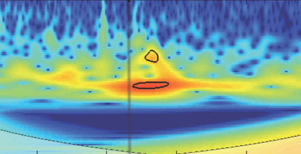
The April 25 magnitude 7.8 earthquake in Nepal created waves of energy that penetrated into Earth’s upper atmosphere in the vicinity of Nepal, disturbing the distribution of electrons in the ionosphere. These disturbances were monitored using GPS signals received by a science-quality GPS receiver in Tibet, a neighboring region to Nepal.
The data show that after the initial earthquake rupture (indicated by the vertical black line on the graphic), it took about 21 minutes for the earthquake-generated ionospheric disturbance to reach a GPS station (LHAZ) about 400 miles (640 kilometers) away from the epicenter in Lhasa, Tibet, China.
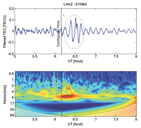
Image Credit: NASA/JPL/Ionosphere Natural Hazards Team The disturbance measurements, known as vertical total electron content (VTEC) (depicted in blue in the upper panel), have been filtered using processing software developed by NASA’s Jet Propulsion Laboratory in Pasadena, Calif., to show wave-like disturbances (circled in red) in the distribution of electrons in the ionosphere. The waves have periods of between two and eight minutes in length. The disturbance measurements following the earthquake rupture are circled in black in the lower panel. The colors represent the relative strengths of the earthquake-induced ionospheric disturbances as captured by the GPS signals, with red being high and blue being low.
Attila Komjathy, a principal investigator of the Ionospheric and Atmospheric Remote Sensing group at JPL and adjunct professor at the University of New Brunswick, is leading this effort. Komjathy is also a GPS World annual award winner and named a Fellow of the Institute of Navigation in January.
The LHAZ GPS station is hosted at the Tibet Autonomous Regional Bureau of Surveying and Mapping Institute. The site collects both GPS and GLONASS (the Russian global navigation satellite system) data at a rate of 1 Hertz and is part of the International GPS Service (IGS).
Scientists study ionosphere-based measurements caused by natural hazards such as earthquakes, volcanic eruptions and tsunamis to better understand wave propagation in the upper atmosphere.The ionosphere is a region of Earth’s upper atmosphere located from about 37 miles (60 kilometers) to 621 miles (1,000 kilometers) above Earth’s surface.
The disturbances caused by earthquakes help scientists develop new first-principle-based wave propagation models. These models may become part of future early warning systems for tsunamis and other difficult-to-detect natural hazards.
The data is available on this FTP site.