Blog

  • The System: All Systems Go, with a Spring into Space

    Planet Earth gained five new navigation satellites in late March, for four satellite systems.

    GPS. The U.S. Air Force’s ninth GPS Block IIF satellite (GPS IIF-9) launched on March 25 from Cape Canaveral, Fla. The IIF-9 rode aboard a Delta IV rocket, the workhorse of the GPS fleet for successful launches. The satellite was declared operational on April 21.

    “Many thought the Delta IV and GPS days were long gone, but the recent questions concerning reliable and proven launch vehicles have brought them back online, so to speak,” said GPS World Defense Editor Don Jewell. “The 20-year milestone for GPS space vehicles on orbit that occurred on April 27 translates to approximately 500 orbital years just for the IIR and IIF constellations alone. The IIAs may account for that many orbital hours as well.

    “This is by far the most successful launch record ever put together by any nation or government. No other space-faring nation even comes close. The U.S. Air Force and all the players should be proud of all these records and more, plus we have one more GPS asset on orbit, providing GPS signals to the world and all they enable, courtesy of the USAF.”

    Galileo. Two days later, March 27, a duo of Galileo satellites was successfully launched from Europe’s Spaceport in French Guiana. The seventh and eighth Galileo satellites rode aboard a Soyuz ST-B rocket. Both are in their planned orbits.

    IRNSS. The next day, March 28, the fourth satellite (IRNSS-1D) of  the IRNSS satellite navigation constellation was launched onboard PSLV-C27, and reached its orbital slot April 9. The Polar Satellite Launch Vehicle blasted off from the Satish Dhawan Space Center on India’s east coast, in the 28th consecutive successful PSLV mission.

    BeiDou. On March 30, China launched the first of a new generation of navigation satellites, BeiDou-3 M1, for its BeiDou constellation. BeiDou-3 M1 is the first of 17 next-generation Beidou navigation satellites. It will have a new navigation signal system with inter-satellite links and other tests to verify the satellite navigation system. The new series of satellites is expected to mark an advancement in the completion of Beidou Phase III several years ahead of schedule, by as soon as 2017 rather than 2020.

    GLONASS. Not making the March launch cut, GLONASS kept its hat in the orbit ring, so to speak, by issuing some far-sighted predictions. Nicholas Testoyedov, CEO of Information Satellite Systems Reshetnev, said that the first GLONASS-K2 spacecraft will be launched into orbit in 2018. “New code division (CDMA) signals will be emitted, so it will provide more accurate positioning for users.”

    The GLONASS budget for 2015 will be cut by more than 5 billion rubles, a drop of more than 10 percent. GLONASS is also suffering through an embezzlement scandal, related to construction of a new ground control center.
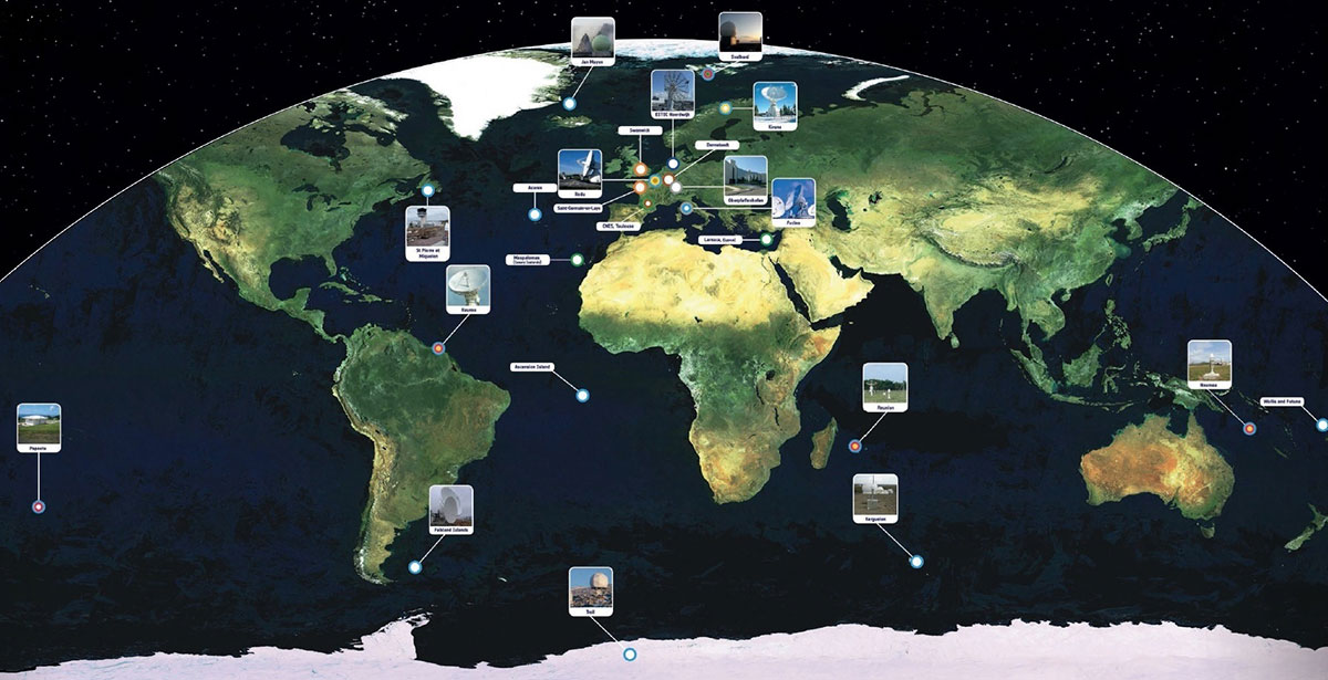
    Galileo's worldwide ground segment as of March 2013.
    Galileo’s worldwide ground segment as of March 2013.

    Galileo Ground Upgrade

    On April 9, the European Space Agency announced completion of a full-scale hardware and software migration to version V2.0 of its global Ground Mission Segment providing all Galileo navigation messages. The Ground Mission Segment was turned off Jan. 26, allowing the migration to take place over the month of February. March was taken up with detailed checking by operations and system, concluding in a final check on March 31 to validate the successful migration.

    “The upgrade has provided better overall performance and availability, along with improved robustness, security and operability,” explained Martin Hollreiser, overseeing mission segment development for ESA, with Thales Alenia Space France as prime contractor. “An overall 25 percent performance improvement is confirmed.

    “Three new sensor stations, Kiruna, Ascension and Azores — used to monitor the satellite navigation signals — were added to the operations chain, as well as a new uplink station in Papeete, to uplink corrections incorporated in the navigation message to the satellites for broadcast to the users.”

    The Ground Mission Segment at its core is determining the exact satellite orbits and synchronizing all the satellite and terrestrial elements of that clock: the relevant control center is linked to a global network of ground stations (sensor and uplink stations). The Galileo signals currently undergo technical testing, with early services for the public projected for 2016. “A further update is foreseen for the end of this year,” Hollreiser added, although this will occur with no interruption of services.

    GPS Glitch Dates from 2011

    On April 15, the U.S. Air Force GPS Directorate said data analysis shows that a technical error affecting some GPS IIF satellites first appeared in 2011. The error affects the way the ground control system builds and uploads messages transmitted by the satellites, but does not affect the accuracy of GPS signals. It involves the ground-based software used to index messages. “A GPS message indexing issue was recently identified that affects a limited number of active GPS IIF satellites, but does not degrade the accuracy of the GPS signal received by users around the globe. The result is an occasional broadcast not in accordance with U.S. technical specifications. ”


  • The Business — May 2015

    The Business section from the May 2015 issue. Download the PDF.

    Includes:

    • Furuno Receiver Adopted for Parrot Bebop
    • NovAtel Launches Relay RTK Radio Module
    • Phantom 3 Has Indoor Positioning
    • SBG Systems Selects Septentrio AsteRx4 for Apogee Series
    • Hemisphere GNSS Offers RTK-Capable Antenna
    • Applanix Offers Three New Marine Products
    • Cobham Aeroflex Tester Used for ADS-B
    • Briefs
    • Events
  • Phase One Releases iX Capture 2.0 Software for Aerial Photography

    Phase One Industrial, a manufacturer of medium format aerial photography equipment and software solutions, has released Phase One iX Capture 2.0, a control, capture and RAW conversion application designed specifically for aerial photography.

    Features include:

    • Support for up to six cameras. iX Capture 2.0 can support full oblique/nadir arrays with multiple Phase One aerial cameras or dual-camera arrays, such as RGB/NIR or arrays to capture wide swaths.
    • Auto Exposure mode. After a user selects a priority with specific ranges set for each parameter, the camera can evaluate the current image and adjust the ISO, aperture and shutter speed for subsequent captures. Auto exposure mode helps operators avoid post flight adjustments in exposure when light conditions change.
    • Offline processing of files and complete folders. iX Capture can now process images post flight, enabling users to process files previously captured or even process the same files, but with different settings applied. With a choice of three offline processing recipes, individual images or folders can be processed individually or simultaneously.

    Learn more at the Phase One website.

  • AirMap Digital Map Enables Safe, Legal Drone Flying

    AirMap-O

    AirMap — a free, comprehensive digital map — allows unmanned aircraft system (UAS) operators to visualize the airspace around them, including areas where they may not be permitted to fly.

    AirMap removes barriers to compliance of complex airspace rules by providing the low altitude airspace information that unmanned aircraft operators need. AirMap was cofounded by aviation expert and entrepreneur Ben Marcus and Gregory McNeal, a legal scholar on drones, public policy and air rights.

    AirMap integrates multiple sources of reliable data and gives UAS operators an easy-to-use, yet detailed, solution providing a single view of the restricted areas around an area of operations, its makers said. The beta version of the site is now live in the U.S. and will launch soon internationally, enabling UAS operators to immediately start benefiting from the free service. AirMap also features a feedback function that will allow beta testers to request additional features.

    AirMap is a fully digital map that shows only the airspace rules that impact UAS operators. By focusing on airspace information from ground level up to 500 feet, AirMap strips away the clutter of higher altitude airspace labels found on charts that were created for manned aviation, its makers said.

    When using AirMap, an operator can customize their display based on the type of operation they are involved in. Operators can select layers depicting the following:

    • Recreational use, which will display the airspace areas around airports which are limited by community-based guidelines;
    • “Blanket COA” rules applicable to holders of FAA Section 333 exemptions for commercial UAS operations; and
    • Controlled airspace (Class B, C, D, and E) at 500 feet and below, allowing UAS operators to voluntarily comply with the airspace rules proposed in the FAA’s recent Notice of Proposed Rulemaking on the Operation and Certification of Small Unmanned Aircraft Systems.

    “As UAS use continues to expand, the airspace in which operators are flying is also growing more complex. With this in mind, we’ve launched AirMap, which will serve as a resource for drone operators to immediately fly safely and in compliance with legal requirements. We want to make safe flying easy,” Marcus said.

    Marcus and McNeal teamed to launch AirMap after they realized that operators needed a tool that would let them understand the complexities of restricted airspace for unmanned aircraft operations. Marcus, who co-founded aircraft brokerage firm jetAVIVA, will lead development and business growth functions. McNeal will apply his expertise and research in local regulatory environments to help AirMap reach and educate users throughout the country. In addition to his role with AirMap, McNeal is an associate professor of law and public policy at Pepperdine University and a Forbes contributor.

    “As a drone operator I found it hard to know what the airspace rules were in the places where I wanted to fly. There were no accurate visuals or reliable electronic tools that could tell me and other operators where we can and cannot fly. AirMap solves this problem and helps to educate operators about this complex regulatory environment,” said McNeal. “The demand for AirMap is clear, as it is the most thorough resource for drone operators to ensure safe, legal and hassle-free flight.”

    AirMap’s advisory board includes Steve Crocker, chairman of the ICANN; Stuart Banner, UCLA law professor and author of Who Owns the Sky?; Tom McInerney, former scientist at Apple; and Mike Mothner, founder and CEO of WPromote.

    In February 2015, AirMap launched its first service, NoFlyZone.org, which accepts registrations from property owners who prefer UAS not overfly their land. These parcels are displayed in AirMap to help operators avoid sensitive areas, and minimize the hassles associated with disputes about where unmanned aircraft should be operating. AirMap also displays hospitals, schools and helipads and will be adding other sensitive sites in the future.

  • Out in Front: Good News for Modern Nav

    This year’s European Navigation Conference in Bordeaux, France, got underway with “Good news from up there .…”

    Galileo’s seventh and eighth satellites launched successfully in late March, the European Space Agency (ESA) plans four more satellites to reach orbit in 2015, and space maneuvers for Galileo 5 and 6 have been completed, with a recovery plan currently under study. ESA happily confirms that satellites 7 and 8 are in good position, under control, and behaving very well.

    Fiammetta Diani, deputy head of Market Development for the European GNSS Agency (GSA), followed her keynote opener with “… some good news also from down here.”

    Galileo_Ionospheric_Model-WThe GSA has just published a new document on the NeQuick Ionospheric Model to compensate for ionospheric errors on Galileo and other GNSS signals. The document, “European GNSS (Galileo) Open Service Ionospheric Correction Algorithm for Galileo Single Frequency Users,” contains detailed description and results from years of research. NeQuick improves accuracy levels globally when using single-frequency services, even during hyperactive periods of the 11-year solar cycle, according to the GSA. This document gets further discussion in my April GNSS Design & Test e-newsletter column.

    The GSA predicts that the installed base of GNSS devices will triple by 2023, with per capita rates of 2.5 in North America, and 2.3 in Europe and Russia. Around the rest of the world, in eight years nearly every person, on average, will possess a GNSS device.

    Axelle Pomies of Galileo Services, an association of industry players active in GNSS applications, stressed the need for a comprehensive, assertive industry policy to support the development of EGNOS/Galileo downstream sector, leading to growth, job creation and autonomy for Europe. She previewed the mid-May publication of a draft position paper in this regard, for wide consultation within the European downstream sector. Follow www.galileo-services.org for its first appearance.

    Concluding the ENC plenary, Florence Ghiron of Topos Aquitaine, a regional council of satnav and intelligent transport companies in southwest France, focused on opportunities and risks for small-to-medium enterprises. One of her points: the long development paths of public and regulatory policy do not help SMEs grow.

    The Galileo Services and Topos Aquitaine presentations receive more lengthy treatment in my online column mentioned above.

    Diani and Ghiron closed with a call to return to Bordeaux in October for the Intelligent Transport Systems World Congress, themed “Towards Intelligent Mobility: Better Use of Space.” GNSS looks to take a more central role than ever in this far-reaching economic segment. Good news — for us — indeed.

  • Expert Advice: Sensor Fusion for Highly Automated Driving

    High-Precision GNSS Needs Help for Continuous Localization Reliability

    By Siamak Akhlaghi

    Automotive safety and comfort functions, known as Advanced Driver Assistance Systems (ADAS), have become an essential part of modern vehicles. These functions assist drivers in the driving process, providing capabilities such as adaptive cruise control or highway driving mode. To achieve a desired level of performance, the position of the vehicle must be known. Precise positioning supports the vehicle’s systems with planning, executing and monitoring of a particular maneuver.

    Position determination, or localization, is the estimation of the location, heading, velocity and acceleration of a vehicle with respect to a fixed coordinate system. High-precision GNSS provides an excellent, worldwide, absolute position reference for localization. However, GNSS technology alone has limitations that must be overcome to make it suitable for use in autonomous systems. For instance, GNSS signals may become blocked or lost due to: obstructions such as in urban canyon or tunnels; multipath, where signals are reflected off the vehicle body; or signal interference from other RF signal sources.

    Siamak Akhlaghi
    Siamak Akhlaghi

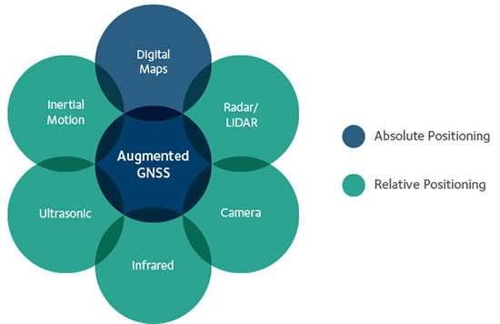
    GNSS correction data and data from other sensors on the vehicle can be used to improve the accuracy and reliability of the vehicle localization solution both globally and with respect to the local environment. To achieve the localization performance, accuracy and integrity required for autonomous vehicles, a multi-system, sensor fusion approach seems to be the most promising. Localization systems will require absolute positioning references like precision GNSS as well as local or relative positioning inputs from inertial sensors, odometers, radar, LiDAR, cameras, infrared and ultrasound sensors. It is clear that no single technology will make highly automated driving possible. Rather, the fusion of the entire vehicle’s sensing technologies will provide the localization accuracy and reliability required.

    Achieving Accuracy and Reliability with GNSS

    GNSS has revolutionized localization in many applications, from precision survey to agricultural guidance. For autonomous driving applications, localization accuracy of 30 centimeters (cm) or less is required. The single-frequency, auto-grade GNSS receivers that have been used in vehicles up to now cannot achieve this level of accuracy. Multi-frequency GNSS receivers utilizing Precise Point Positioning (PPP) correction techniques can achieve accuracies better than 10 cm. PPP algorithms combine GNSS satellite clock and orbit correction data from a global reference station network with high precision GNSS receiver satellite observations to yield robust sub-decimeter positioning without the need for local base stations. Since the PPP corrections can be delivered via satellite, the solution is ideal for highly automated driving where communications infrastructure is costly and in some areas may not be available. Recent advances in PPP techniques provide robust positioning and the ability to quickly regain full accuracy following a temporary loss of GNSS signals, for instance under foliage or highway overpasses.

    Figure 1. High precision / localization with sensor fusion.
    Figure 1. High-precision / localization with sensor fusion.

    Sensor Fusion

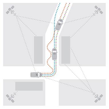
    Occasional instantaneous irregularities and temporary outages of GNSS can be compensated for by incorporating measurements of the vehicle motion from inertial sensors mounted in the vehicle. An advantage of a tightly coupled GNSS-inertial solution is that the low frequency errors inherent to inertial sensors can be compensated for and removed from the solution. As a result, sensor fusion algorithms provide a highly robust and stable localization solution at data rates as high as 200 Hz. Other sensors in the vehicle, such as odometers, cameras or LiDAR, can also give information about the relative motion of the vehicle and can add to the redundancy, reliability and stability of the localization solution.

    Figure 2. With a tightly coupled GNSS-inertial solution, low-frequency errors can be removed from the localization solution. The brown dots are the GNSS solution, the blue dots are the inertial solution, and the combined colors represent the tightly coupled solution.
    Figure 2. With a tightly coupled GNSS-inertial solution, low-frequency errors can be removed from the localization solution. The brown dots are the GNSS solution, the blue dots are the inertial solution, and the combined colors represent the tightly coupled solution.

    High-Precision GNSS Antenna

    Antennas play a critical role in achieving precise localization with GNSS. While GNSS antenna requirements differ depending on the application, ideally the antenna should receive only signals above the horizon, have a known and stable phase center that is co-located with the geometrical center of the antenna, and have perfect circular polarization characteristics to maximize the reception of the incoming signals. Highly automated driving applications demand high performance as well as compact size and strong interference rejection. Achieving the required performance amidst these challenging constraints will require innovative new GNSS antenna designs.

    Autonomous driving will be a reality in the not-too-distant future. Innovation in the suite of sensors and fusion algorithms used for solving the localization challenge will be paramount to making safe and reliable autonomous vehicles. Further, innovation developed for automotive autonomy will support new autonomous vehicle applications in other segments.

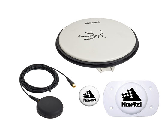
    High-precision antennas are key.
    High-precision antennas are key.

    Siamak Akhlaghi is segment manager for Autonomous Systems at NovAtel. He has 20 years of professional experience working for high-tech sectors with broad experience in inertial sensors and navigation systems.

  • TopoDrone-100 Captures Near Infrared Mapping Data

    DroneMetrexNIRfarm

    DroneMetrex has captured high-quality near-infrared (NIR) mapping data with its TopoDrone-100 UAV. DroneMetrex said in a news release that this is the first time such high quality NIR imagery has been captured by a UAV.

    High-quality NIR data is a tool to detect chlorophyll. Because chlorophyll is emitted by all vegetation to various degrees, experts from land and forest departments, agronomists, vignerons and pastoralists will be able to discriminate between health and vigor of vegetation and between different types of vegetation. The data collected helps determine vegetation stress, disease, pest infection, irrigation faults and nutrient variations.

    “We say ‘unique high-quality mapping’ because the data are both radiometrically and geometrically unparalleled from a drone,” said Thomas Tadrowski, managing director of DroneMetrex. “From the one-flight sortie, TopoDrone-100 users are able to perform vegetation analysis mapping as well as accurate 3D contours/DTM mapping. The pixel resolution is unsurpassed. The data geometry is unsurpassed. The radiometric mapping is unsurpassed.”

    DroneMetrex offers its Extended Spectrum Mapping (ESM) camera modification as an option with the TopoDrone-100. After ESM modification, the camera is supplied with three external screw-on lens filters. Simultaneously using the NIR filter and a high-accuracy L1/L2/L5/GLONASS/COMPASS (BeiDou-2) PPK direct georeferencing solution, the TopoDrone-100 captures three-band imagery, with the near-infrared band recording unparalleled radiometric quality and chlorophyll discrimination.

    The high radiometric quality is achieved because DroneMetrex specialists perform the necessary camera modifications themselves, and have designed the external filters specifically to match the requirements of accurate, discriminative vegetation mapping, DroneMetrex said.

    DroneMetrexVeg01NIR
    Burnt vegetation.
    DroneMetrexBurntVeg01NDVI
    Burnt vegetation NIR.
  • 4D Inspector for Building Monitoring Comes to MundoGEO

    Gexcel’s 4D Inspector will be officially presented to the South American market during MundoGEO, to be held in Brazil May 5-7.

    4D Inspector software can remotely manage any Focus3D laser scanner and run an automatic 3D monitoring session of buildings and infrastructures. 4D Inspector automatically transfers the scans to a remote PC where automatic deformation check runs and alarm emails can be sent to the site managers.

    If required, 4D Inspector can also control a protective enclosure (ScanArmor) that can protect the Focus3D from damages.

    The 4D Inspector+ScanArmor system has won the FARO Asia Pacific Product Innovation Award 2014. Designed for real-time monitoring of indoor application, 4D Inspector is has easy-to-use interface and installation procedures, according to maker Gexcel Software Solutions.

    Gexcel will provide will provide an interactive demo at its booth, #187, at MundoGEO.

  • TomTom’s New Devices Have Lifetime Maps, Speed Cameras

    TomTom’s New Devices Have Lifetime Maps, Speed Cameras

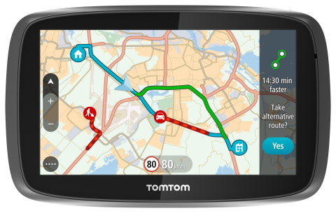
    TomTom is introducing Lifetime World Maps and Lifetime Speed Cameras to drivers with the launch of four new TomTom navigation devices.
    TomTom is introducing Lifetime World Maps and Lifetime Speed Cameras to drivers with the launch of four new TomTom navigation devices.

    TomTom is introducing Lifetime World Maps and Lifetime Speed Cameras to drivers with the launch of new TomTom navigation devices. Lifetime World Maps allow people to drive with maps from around the world at no extra cost, for the lifetime of their TomTom GO device2. Lifetime Speed Cameras let drivers know the locations of all speed cameras — both fixed and mobile, also for the lifetime of the device.

    The TomTom GO 510, 610, 5100 and 6100 feature a fully interactive screen to pinch, zoom and swipe — as well as a rich user interface, simplified user interaction, 3D Maps and a Click & Go mount. Drivers can also choose between a 5-inch or a 6-inch screen size, TomTom said. The new TomTom GO devices also include “Drive Home” and “Drive to Work” buttons in the main menu, for faster, simpler navigation.

    TomTom GO devices combine real-time traffic information with routing technology, to always offer drivers the fastest route available. TomTom Traffic covers all mapped roads and combines data from millions of data sources, from all over the world, to deliver traffic information so accurate that, with each new update, it can pinpoint the start and end of a traffic jam, precisely, down to 10 meters.

    “With the addition of Lifetime World Maps and Lifetime Speed Cameras to our new TomTom GO devices, we’re offering the most comprehensive package to drivers that we’ve ever launched,” said Corinne Vigreux, co-founder and managing director, TomTom Consumer. “Our aim is to help you avoid the jams, getting to your destination faster, wherever in the world you might be.”

    Lifetime TomTom Traffic is available via a smartphone connection on the TomTom GO 510 and 610. The TomTom GO 5100 and 6100 offer Lifetime TomTom Traffic via a built-in SIM with unlimited data and roaming at no extra cost.

    The new TomTom navigation devices are compatible with TomTom MyDrive4. For the first time, drivers can use their smartphone, tablet or PC to review real-time traffic information, plan routes, and send destinations to their TomTom GO, before they get in the car. Previously launched TomTom GO devices5 are also compatible with MyDrive though a simple software update. Find out more about TomTom MyDrive here.

    The new TomTom GO devices are now available online and in-store from €199.95.

  • Esri CityEngine 2015 Provides Advanced 3D City Design

    esri-cityengine-2015-provides-advanced-3d-city-design-lg
    Modern layer management and enhanced real-time shadows based on daytime and location are available in the latest release of CityEngine.

    The release of Esri CityEngine 2015 allows GIS professionals, architects, planners, and urban designers to create 3D city models faster and share them easily via ArcGIS Online. These new features open the use of 3D models for every day, real-world simulation, emergency response, urban planning, and entertainment scenarios.

    “CityEngine 2015 is faster, sports higher-quality visuals, and introduces an innovative and unique 3D design experience. The latter is possible with Procedural Handles, a novel user interface for the intuitive editing of 3D models. We worked very hard on this and are excited to release it,” said Pascal Mueller, director of the Esri R&D Center, Zurich AG.

    Companies like Esri partner SmarterBetterCities use CityEngine to help clients view and investigate building development proposals in a true 3D environment.

    “CityEngine provides decision makers with the opportunity to do more advanced planning than when they are using a typical CAD or spreadsheet system,” said Antje Kunze, CEO, SmarterBetterCities. “We are now able to help our clients better visualize rules and regulations and perform analytics that no one has been able to address in the past.”

    Advancements from user requests—including a modern editor for managing layers, real-time shadows based on daytime and location, faster data export, and improved publishing workflows—have been implemented. More information can be found in the release notes.

    “With CityEngine 2015, we made a huge step forward in user experience and speed, resulting in less coding and more designing,” said Dominik Tarolli, director of international business development for 3D geodesign at Esri.

    CityEngine 2015 is available for Windows, Mac, and Linux platforms. A free 30-day trial with full export capabilities can be downloaded at esri.com/cityengine.

    Esri-CityEngine-O
    Credit: Esri website.
  • FAA Awards Harris $238M Contract for Weather Support

    The Federal Aviation Administration (FAA) has selected Harris Corporation for an eight-year, single-award indefinite delivery/indefinite quantity (IDIQ) contract with a potential value of $238 million to design and implement a system that will disseminate real-time, comprehensive weather pictures to all aviation users across the National Airspace System.

    The Common Support Services–Weather (CSS-Wx) program will help minimize flight delays and cancellations by providing additional weather data with increased accuracy to more aviation consumers, supporting real-time operational planning and decision-making.

    “About 70 percent of flight delays are caused by weather,” said Carl D’Alessandro, vice president and general manager, Civil Programs, Harris Government Communications Systems. “The enterprise-wide, data-sharing design of the CSS-Wx solution will reduce these delays, saving the FAA and flying public precious time and money.”

    The Harris CSS-Wx system is scalable, with Open Geospatial Consortium standards for common weather formats, and highly advanced geospatial- and temporal-based filtering methods to process meteorological data. It applies expertise the company has gained from work on mission-critical weather programs for the FAA, the National Oceanic and Atmospheric Administration and the Department of Defense.

    Harris has a long history of developing and integrating system solutions for the FAA in support of the National Airspace System (NAS). The company is the prime contractor for the FAA Telecommunications Infrastructure (FTI) program, which provides critical voice, data and video communications for NAS operations and mission support functions. FTI securely connects more than 4,500 national and international FAA and DOD facilities, manages over 26,000 services, and supports more than 50,000 users. Other FAA programs developed by Harris include:

    • The Weather and Radar Processor, which provides weather processing dissemination and display capabilities to air traffic controllers in the en-route air traffic control environment;
    • Datacomm, which provides air-to-ground digital data link networks to connect FAA air traffic control sites and data communications-equipped aircraft;
    • The NAS Voice System, which provides a secure, IP-based voice network for critical communications between air traffic controllers, pilots and ground personnel nationwide;
    • The Operational and Supportability Implementation System, which serves the General Aviation community in Alaska by providing weather briefing and flight planning services; and
    • The National Air Space Enterprise Messaging Service, which will provide the FAA with the network-centric, collaborative information-sharing capabilities afforded by System Wide Information Management.
  • Optech to Exhibit LiDAR, Imaging for UAVs at AUVSI

    Optech Galaxy LiDAR system.
    Optech Galaxy LiDAR system.

    Optech will be exhibiting its latest lidar and imaging solutions at the Unmanned Systems 2015 Conference in Atlanta, Ga., May 4-7, at the Teledyne Booth 2311. Optech’s solutions include a fully implemented lidar/camera workflow for UAV operations, as well as other airborne, mobile and stationary sensors.

    Visitors can drop by the booth to learn more about Optech’s UAV solution, which combines the rugged Optech ILRIS terrestrial laser scanner and the new Optech XR6 photogrammetry small UAV with an integrated software workflow. The solution merges aerial camera imagery from the UAV with high-resolution data from Optech lidar to deliver comprehensive, georeferenced and highly accurate 3D planimetric data. The ILRIS lidar system can also be operated remotely through a web interface.

    For advances in airborne sensing and surveillance using mid-size to larger UAVs, Optech will discuss the features of the compact Optech Galaxy lidar system and its PulseTRAK technology, which ensures a continuous operating envelope and steady point density even in rugged terrain, vastly simplifying mission planning, and eliminating “blind zones” — overcoming a long-standing limitation inherent to lidar sensors lacking PulseTRAK technology. Galaxy is compatible with all Optech mounts for integrating digital metric cameras, enabling clients to customize their solution with the right mix of LiDAR, multispectral, LWIR, MWIR and RGB sensors for their application.

    Optech will also be showcasing the Optech Titan, a commercial multispectral airborne lidar, which accomplishes highly automated land classification using its separate 532, 1064 and 1550 nm laser channels, and performs combined topographic/bathymetric mapping down to a depth of 15 meters in clear conditions.

    Visitors who need rapid coastal monitoring and object detection will be particularly interested in the new Optech CZMIL Nova, Optech’s upgrade of the award-winning CZMIL airborne bathymetric mapper. CZMIL Nova maintains its predecessor’s sensing power, including its unmatched turbid water penetration, while boosting installation flexibility and cost savings with a more efficient laser and much lighter hardware, facilitating operation in smaller aircraft.