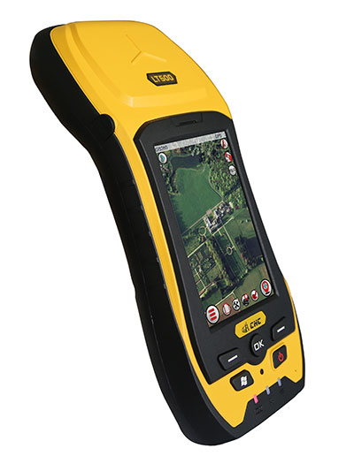
CHC has launched the LT500 series of handheld GPS receivers. The LT500 series LT500N /LT500T/LT500H covers three accuracy ranges from sub-meter to centimeter accuracy and is a cost-effective full GNSS positioning solution for survey, construction and GIS professionals.
Powered by the Windows Embedded Handheld 6.5 operating system, the LT500 is accurate, rugged and versatile, CHC said. User productivity is enhanced with the built-in gyroscope, an innovative laser plummet for positioning the accurate handheld receiver over a point, an E-compass for showing the direction and G-sensors for leveling.
The LT500 series is competitively priced and comes with several bundled software programs, including SurvCE, DigiTerra, MapCloud and other third-party software.
“CHC’s LT500 series is our brand-new GNSS handheld, which has amazing features and specifications. It meets more customers’ needs with more options and affordable prices,” said George Zhao, CEO of CHC. “The introduction of the LT500 demonstrates CHC’s commitment to provide the GIS community with a full spectrum of rugged, cost-effective professional GPS handhelds.”
The CHC LT500.
The LT500 series features these specifications:
1-GHz high-speed CPU with 512-MB RAM and 16-GB flash memory built-in
Compare pre- and post-earthquake imagery from Airbus Defence & Space to explore damage around Nepal. This map includes several bookmarks to help users navigate around key points of interest and landmarks that were damaged or destroyed.
Users can interactively explore demographic information about the people affected by the earthquake. The map fuses demographic data with the Shakemap from USGS to provide estimates about the population in each shake zone. Click a zone on the map to see how many people live in that area.
Compare pre- and post-earthquake imagery from Airbus Defence & Space to explore damage around Nepal. This map includes several bookmarks to help users navigate around key points of interest and landmarks that were damaged or destroyed.
Users can interactively explore demographic information about the people affected by the earthquake. The map fuses demographic data with the Shakemap from USGS to provide estimates about the population in each shake zone. Click a zone on the map to see how many people live in that area.
Students still have time to join the ESA International Summer School on Global Navigation Satellite Systems, which will take place in Barcelona, Spain, at the end of August.
The 10-day course — lasting from the afternoon of Aug. 31 to the morning of Sept. 10 — will cover all aspects of satellite navigation, up to and including the creation of a satnav-based business.
Hosted by the University of Barcelona at the four-star Hotel Alimara, the Summer School is open to graduate students, PhDs and postdoctoral researchers, as well as young engineers and academics working within industry or agencies, aged 35 or younger.
Internationally renowned scientists and specialists will be giving lectures as well as overseeing practical exercises and lab work. Participants will receive a full-spectrum overview of satellite navigation, starting from the theoretical basis of the Global Navigation Satellite System (GNSS), its signals, the processing performed by signal receivers and how the position-navigation-time solution is worked out.
Discussion will also be made of threats to satnav systems, such as spoofing or jamming, and the countermeasures available against them, along with back-up navigation solutions for a GNSS-denied environment.
Practical exercises will include receiving the various satnav constellations now in orbit — including Europe’s eight-satellite Galileo, the foundation of the full system soon to come — to give course members direct, hands-on experience.
In addition, lectures will cover business aspects, including patents and intellectual property rights.
The main emphasis of the course will be the development of a group business project, building on an innovative idea to take in the planning of the product or service, its technical realization and finally its marketing to customers.
Register before the end of May to benefit from an early registration discount. The number of participants is limited to 50, on a first-come, first-served basis.
The ESA International Summer School is taking place in conjunction with the GNSS Summer School of the Joint Research Centre of the European Commission, and is organized by Universitat Politecnica de Catalunya (UPC) in cooperation with Stanford University in the US, the Institut Supérieur de l’Aeronautique et de l’Espace in France, Graz University of Technology in Austria and University FAF Munich in Germany.
Aeryon Labs, GlobalMedic and Monadrone are working together to deploy three unmanned aerial systems (UAS) in Nepal to help locate earthquake survivors. The drones are outfitted with thermal cameras and the Aeryon HDZoom30 camera, which has an extended zoom, to look at targets from more than 1,000 feet away.
On Saturday, April 25, a 7.8 magnitude earthquake struck Nepal — the largest quake in 81 years in the region. More than 4,000 people have died, with death tolls expected to rise as the rubble is cleared.
In response, Aeryon Labs deployed three of its sUAS (small UAS) and a qualified Aeryon pilot to the affected region. Aeryon is collaborating with partners GlobalMedic and Monadrone to provide aerial support to international disaster relief teams on the ground.
The Global Medic UAV team responded immediately to the crisis in Nepal. “sUAS provide us the unmatched capability to get onsite and into the air immediately to start determining how and where to provide support to the people,” said Rahul Singh, executive director of GlobalMedic.
Damage to, or the complete loss of, fundamental infrastructure such as airstrips and refueling facilities can make manned aircraft operations in disaster relief scenarios very challenging. Sending rescue workers into damaged structures, or rubble piles, to search for survivors also puts them in harm’s way. sUAS enable ground-based rescue teams to collect critical visual intelligence and deploy rescue resources quickly, carefully and exactly where they are most needed, the companies said.
The Aeryon HDZoom30 is a fully-integrated, ruggedized, high performance electro-optical camera payload for UAS.
The Aeryon sUAS being sent to Nepal are equipped with thermal cameras to help locate survivors by detecting body heat, as well as the companies newest imaging payload, the Aeryon HDZoom30, which can be used at extended distances to zoom in to see a target with clarity and detail. For example, operators are able to recognize a face from more than 1,000 feet (300 meters) away. The team will also undertake aerial mapping of the affected areas, building 2D and 3D maps, so that further response efforts can be planned.
“At Monadrone, we see sUAS as mission-critical tools that not only support day-to-day military, police and fire department needs, but can also play a vital role when disaster strikes,” said Robin Morris, director at Monadrone, Monaco. “The images the Aeryon sUAS will capture will enable the creation of up-to-date maps required to aid the disaster relief in Nepal.”
Aeryon sUAS were also deployed in the aftermath of the August 2014 landslide that devastated the region along the banks of the Sunkoshi River in northern Nepal. Despite the high altitude of Nepal, which is challenging for many aircraft, and the rugged terrain, Aeryon sUAS proved effective and more than up to the task.
“UAS are uniquely able to provide immediate support for disaster relief, like the earthquake in Nepal, helping rescue teams search more effectively, efficiently and safely,” Dave Kroetsch, president and CEO of Aeryon Labs, told AUVSI News. “It’s an honor to see the technology you create make such a difference. We are privileged to be able assist the aid workers who are helping the people of Nepal.”
u-blox, a wireless and positioning module maker, has become a member of the CAR 2 CAR Communication Consortium. The industrial-driven consortium is dedicated to the development and deployment of Cooperative Intelligent Transport Systems (C-ITS).
The consortium’s ultimate goal is to improve road traffic safety and efficiency. It is working to develop roadmaps for vehicle-to-vehicle (V2V) and vehicle-to-infrastructure (V2I) communications and to harmonize related standards. Lane-accurate positioning and short-range communication technology, both a focus of u-blox, play an important role for ITS applications.
u-blox is a provider of wireless positioning and communications modules and chips to the automotive industry. “We see the work of the CAR 2 CAR Communication Consortium as pivotal to the success of C-ITS deployment, both in Europe and further afield,” u-blox CEO Thomas Seiler said. “Its working groups and technical committee are undertaking very important work to ensure that vehicle communications technologies will contribute to saving lives and reduce injury by making our roads safer. We’re delighted to be able to contribute to that effort.”
CartoDB and DigitalGlobe are partnering to bring satellite data to mapmakers everywhere in order to help them visually explain the events and information shaping the world. The new offering will provide users of all levels with access to the latest satellite content from DigitalGlobe, enabling journalists, publishers, bloggers and web developers to easily incorporate high-resolution imagery into their online content in a matter of minutes.
CartoDB is an open-source mapping and visualization tool that allows anyone to create interactive maps with their own data. The cloud-based solution includes the CartoDB Editor, an online tool that enables anyone to analyze and visualize location data, enabling publishing features and collaboration tools. Those looking to do even more with their data can use the CartoDB Platform, a mapping engine that offers a set of APIs and libraries to help users create maps, manage their data and run geospatial analyses. For examples of maps created using CartoDB, visit the Map Gallery.
“Our collaboration with DigitalGlobe is a significant development for anyone who publishes stories about our world,” said Javier de la Torre, co-founder and CEO of CartoDB. “This partnership will democratize access to high-resolution satellite imagery and data on-demand, incorporating satellite images into interactive stories and content at an affordable price point. The combined power of DigitalGlobe’s extremely current satellite imagery and CartoDB’s easy-to-use platform will enable creative storytellers to communicate and contextualize data with the simple click of a button.”
The platform enables access to high-resolution imagery captured as recently as 24 hours ago, and archive imagery dating back to 2011. A CartoDB Enterprise account is availale.
“Seeing a better world just got easier and faster for journalists, media outlets, and researchers who want to add geospatial context to their online content,” said Josh Winer, sales manager of DigitalGlobe. “With the ease of CartoDB’s mapping tools and platform, customers of any size can quickly and easily integrate high-resolution satellite imagery into their online maps and stories. We’re thrilled to partner with CartoDB and look forward to empowering their community.”
Following Nepal’s devastating magnitude 7.8 earthquake on Saturday, Airbus Defence and Space has acquired Pléiades satellites imagery to support the International Charter and Copernicus Emergency Management Service. The data acquired will assist in assessing the damage and help rescue organizations in the delivery of humanitarian aid.
The before and after Pléiades images over Kathmandu (full image can be downloaded here) show the devastation caused by the earthquake. The below “before” Pléiades image was acquired on Nov. 29, 2014, and the “after” Pléiades image was acquired on April 27, 2015, two days after the earthquake.
Kathmandu, viewed by Pléiades satellites, before and after the earthquake. (Image: Airbus Defence and Space)
The Airbus Pléiades 1A and Pléiades 1B satellites operate as a constellation in the same orbit, phased 180 degrees apart. The identical twin satellites deliver high-resolution optical data products and can revisit any point on the globe, according to Airbus.
UPDATE:
Esri has created a Nepal Earthquake Swipe Map, which allows users to compare the pre- and post-earthquake images from Airbus Defence & Space to explore damage around Nepal. This map includes several bookmarks to help users navigate around key points of interest and landmarks that were damaged or destroyed.
Great view of the Pentagon while departing from the U.S. Hydro conference held in Washington, D.C.
I’ve attended five conferences in the past couple of months; Esri Water Conference (first one!), Esri Partner Conference, US Hydro 2015, APSG (Association of Petroleum Surveying & Geomatics) and the Esri Petroleum User Group (PUG) conference. It may look Esri-heavy, but the fact is that Esri is doing a really good job of organizing vertical market GIS conferences, and people are showing up. Even with crude oil prices in the cellar (relatively speaking), 1,200 people still showed up at the PUG.
There were a lot of good presentations at these conferences, and I’ll post links to some of them below. Not surprisingly, drones are a major topic of discussion at most GIS conferences. There was even a drone demo (I missed) at the Esri Partner conference showing Esri’s workflow in working with drone-collected data.
If you don’t follow me on Twitter, you might consider it. Twitter is easy and free. When I’m at a conference, I send tweets (most with a photo) in near real-time when I see something of interest. For example, I tweeted when Jack Dangermond showed up at the Esri PUG (he usually doesn’t, but did this year because it was the 25th annual conference) and had something interesting to say (read below). You can sign up for Twitter here, and then choose to follow me at https://twitter.com/GPSGIS_Eric. I get that you may be hesitant to invest any time in this, but it looks like Twitter is becoming the standard for near real-time news (as opposed to other social media such as Facebook or LinkedIn.)
Of all the new technology I’ve heard about over the past few months at these conferences, two subjects continue to excite me.
Drone Mapping. Of course, one of them is drone technology for mapping. It seems like I’ve beat this horse to death over the past few months, but it continues to get juicier and juicier. Technology development in this industry is moving really fast. It seems like new drones are being announced as frequently as new smartphones, maybe more so.
Other ancillary technologies are being developed to support commercial drone operations. For example, in my hometown (Portland, Ore.), a company called Skyward just raised $4+ million in venture capital funding to provide “professional services for UAV operations.” Essentially, the company’s software helps drone operators stay within FAA regulatory compliance.
Last year, the Oregon Unmanned Systems Business Enterprise was formed “with a two-year $882,000 state grant from the Oregon Business Development Department and the Oregon Innovation Council and will be working to match the government money with private investment and other grants.” The organization will award grants up to $75,000. The point is, the money is flowing and it’s a wide-open market.
The drone market is so wide open, in fact, that most drone companies are just buying common airframes and associated parts, putting their brand name on them, and selling them. Perhaps oversimplified, but the point is there’s not much “special sauce” (technology) being added. The manufacturers that aren’t innovating and adding valuable “special sauce” will eventually disappear. Essentially, following are the parts needed for a fixed-wing drone for mapping:
Aircraft components:
Airframe (off the shelf)
Motor (off the shelf)
Servos (off the shelf)
Propeller (off the shelf)
Radio (off the shelf)
GPS (off the shelf)
Autopilot (off the shelf)
Batteries (off the shelf)
Camera trigger (off the shelf)
Camera (off the shelf)
Ground compoments:
900-MHz controller (off the shelf)
Battery chargers (off the shelf)
Mission planning software (off the shelf)
Propeller balancer (off the shelf)
As you can see, all of these components are available off the shelf. You can order each component (maybe all of them from Amazon!), have them shipped to you, and assemble your own UAS for mapping. That said, someone who has gone through the process of building, flying and producing a valuable deliverable that you can make decisions from can add value. But, as competition increases, there’s no doubt that the companies that don’t offer much added value will not be able to operate a sustainable business.
Finally, the U.S. Federal Aviation Administration (FAA) is being surprisingly nimble, approving “333 Exemption” requests at record pace and moving towards using a “summary grant” process to issue bulk approvals of 333 Exemption requests for commercial operations.
UAS presentation from Texas A&M University, one of six FAA-designated UAS test sites.
You may want to take a look at some of the other presentations at the APSG meeting. They were very good. Here’s a quick summary of each by Jon Stigant, long-time member of APSG:
This was a primer in LiDAR technology and methodology — while most of the paper is well understood in the survey community, it is and excellent overview. A reminder for some and a way to fill in the gaps for those not so close to this technology.
Integration of UAVs into O&G Operations — Stacey Lyle, BP (presentation forthcoming)
Stacey provided a valuable summary of the direction in which the FAA is going to regulate the emerging UAV technology. A “must read” for any company that intends to either provide or use this technology. As with most government regulation there is a lot of detail, the devil is in them. Stacey recommended that the APSG engage by developing some standards for the oil and gas industry.
Ron Hughes theme is massive data and managing it — also something of a common theme for all the talks. He focused on automating data processing and recommended a concept of doing this in an automated way with 80 percent of the data. This requires careful procedural development in collaboration with a given client’s business workflows. He gave an example of a large utility company, and how the development of an enterprise metadata server had functional impact for individual business units, but also had the knock on impact of improving inter-functional/inter-community collaboration within the enterprise.
Mike provided input on Geiger mode LiDAR, differentiating Harris’ approach from the more regular LiDAR methodology. The major difference is in data density, data frequency, volume and speed used from higher flying aircraft covering a larger area faster. Providing 10-cm accuracy and expecting 7-cm acuracy development using a/c at 25,000-ft height. Focus on fast processing of immense data volumes (pedabytes) – 24-hour delivery using Harris proprietary processing. Achieve higher density at lower cost.
Mark introduced developments in GIS associated with Common Operating Picture (COP), focusing on the combining of video and data in GIS system. DPFOS mnemonic: Data Management, Planning & Analysis, Field Mobility, Operational Awareness, Stakeholder Engagement. A new SIMOPS (SIMultaneous OperationS). The key is a single source of approved data. Examples of data required in COP from specific disciplines are provided — ROVs, shore clean-up, life of field data, asset and material tracking, live/recorded video, RT data and weather integration, “in the field’” vessel implementation.
GIS, Geospatial, Geomatics…Organizational Capability Evolution — Brian Boulmay, BP (presentation forthcoming)
Rethinking Geospatial Data Management at a major operator. One Map program — not physical, one-way provision. Focus on users vs. geospatial specialists. Users business driven, specialists IT and S driven. Geospatial data integrity and analytics – people, processes and technology. ID goals — massive deployment worldwide — has to be automated. Federated system — regions only have to deal with their own regional data, not be overwhelmed by whole enterprise on their doorstep. IT has the role of providing/maintaining a worldwide solution.
Update on Spring 2014 APSG meeting — All major networks launching satellites. Very soon will have 30 live in-view satellites (U.S., Russia, Europe and China). RTK coverage in China is the best due to BeiDou, supplemented by both Indian and Japanese systems SBAS. $100 RTK on cell phone giving centimeter accuracy eventually, and changing the commercial dynamic!
Set up for managing and analyzing LiDAR data in Global Mapper. Workflows: terrain modeling, visibility, biomass (change monitoring); asset: inspect and maintain pipelines, as-built modeling, simulation. High-accuracy at relatively low cost, outpacing regulatory management. Much public data available — earthexplorer.usgs.gov. xyz values — minimum height threshold, dense RGB point cloud (almost photographic).
Automated dashboard approach, reducing pilot distraction risk, speeding up RT transfer and operational activity reporting.
Esri Conferences
Here are a couple of neat things from the Esri conferences.
First, Jack Dangermond was his usual visionary self at the Esri PUG conference, making his appearance for the 25th annual PUG. He is a master at communicating his GIS vision.
The Evolution of GIS.
In speaking about the evolution of GIS, Mr. Dangermond spoke about the far-reaching impact of email and stated that eventually web-based GIS will be deployed organization-wide, just like email. I agree with this vision. I believe the only question is timing. Is it two years from now? Five years from now? 10 years?
Onto the less visionary and more tactical tidbits…
Of particular interest to me is high-precision GNSS in the Esri environment. A lot of people I talk to are screaming for this. What does high-precision GNSS in the Esri environment mean?
support for high-precision metadata in ArcGIS Collector (ArcPad already supports this).
support for high-precision horizontal (eventually vertical) datum transformations in ArcGIS Collector.
This is important because Esri is supporting ArcGIS Collector across all mobile platforms (Android, iOS and eventually Windows), and people want to use their smartphones and tablets. ArcPad will never run on iOS or Android, so Collector is the GIS collection tool of choice, at least for the Esri environment. It needs to support high-precision GNSS, and by the looks of the following slide, it will. It’s just a matter of timing…
ArcGIS Collector to support high-precision GNSS.
The other potentially neat product Esri announced was Navigator for ArcGIS. Imagine trying to guide a work crew to a buried valve across town (or in the next neighborhood). Displaying a system or region-wide map of valves would not be an efficient way of driving your way across town to find the valve. However, giving a crew turn-by-turn street directions to the street-level, then displaying the valves on that street section, might be a very efficient way of finding the valve.
In response to the devastating 7.8-magnitude earthquake that struck central Nepal on April 25, DigitalGlobe has made high-resolution satellite imagery of the affected areas freely available online to all groups involved in the response and recovery effort through the company’s FirstLook initiative.
The below before and after images show the destruction of the nine-storey Dharahara Tower, which was built in 1832 and was a UNESCO World Heritage site.
The Dharahara Tower in Kathmandu, in a DigitalGlobe satellite image taken in October 2014. (Image credit: DigitalGlobe)The Dharahara Tower is shown leveled following the earthquake (Image credit: DigitalGlobe).
Specifically, DigitalGlobe activated FirstLook, the subscription service that provides emergency management and humanitarian workers with fast, web-based access to pre- and post-event images of the impacted area. DigitalGlobe captured imagery of the area April 26 through heavy cloud cover with its WorldView-1, and WorldView-3 and GeoEye-1 satellites. WorldView-2 and WorldView-3 have been tasked to image the area again April 28. Pre-event imagery dating back to April 1 is also available to aid understanding and coordination for on-the-ground missions.
In addition, DigitalGlobe has activated Tomnod, the crowdsourcing platform that allows web-connected volunteers around the globe to help disaster response teams by mapping damage from this earthquake. While satellite imagery on its own is useful, greater benefit comes from extracting meaningful information that can be used by first responder and recovery agencies.
By visiting the Tomnod website, users can participate in the Nepal campaign by tagging damaged buildings, roads, and areas of major destruction to inform disaster response teams on the ground. Whether a person donates five minutes or five hours, anyone can analyze DigitalGlobe imagery to help make a difference.
Topcon Positioning Systems has received a national exemption from the Federal Aviation Administration (FAA) that allows for operation of its unmanned aerial system (UAS) in the United States. The exemption covers the operation of the Sirius Basic and Sirius Pro for aerial data collection.
The Sirius Pro and Sirius Basic systems are designed to produce accurate solutions for the automated mapping of a wide range of sites — regardless of terrain — including construction sites, mines and quarries. The UAS are designed for land surveying, transmission line and pipeline inspection, and agricultural operations such as field mapping and livestock management. With the Sirius Pro model, Topcon eliminates the need for ground-control points by combining real-time kinematic (RTK) GNSS solutions with precision timing technology to provide accurate mapping results, Topcon said.
“This exemption is exciting news for the U.S. marketplace,” said Eduardo Falcon, executive vice president and general manager of the Topcon GeoPositioning Solutions Group. “It allows Topcon to be a resource for end-users and provide UAS demonstrations and training. Aerial data collection has a strong impending impact on all the industries we serve, and the possibilities for survey, construction, and agricultural applications are seemingly limitless.
“Building on the success the Sirius models have already seen in the European and Australian markets, this exemption allows Topcon to expand on that momentum in the U.S.,” Falcon said.
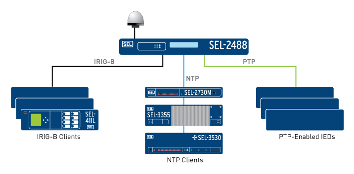
Schweitzer Engineering Laboratories, Inc. (SEL) has added support for the Precision Time Protocol (PTP) to its SEL-2488 Satellite-Synchronized Network Clock. In a single clock, users can now synchronize end devices with sub-microsecond accuracy using demodulated IRIG-B and/or PTP. The SEL-2488 can meet all the timing needs of industrial and utility applications.
The SEL-2488 offers security features, including Satellite Signal Verification in which the clock uses two satellite constellations to validate time signals, providing a layer of protection from GPS spoofing attacks. For fault tolerance, customers can opt for a second, redundant hot-swappable power supply, which can be connected to a second power input source. If GPS is lost, the clock switches to a standard TCXO holdover with 36-microsecond-per-day accuracy or an optional OCXO holdover with 5 microsecond average accuracy. The clock operates over a wide temperature range of –40° to +85°C (–40° to +185°F) and is backed by SEL’s 10-year, no-questions-asked worldwide warranty.
In addition to providing IRIG-B and NTP outputs, the SEL-2488 can now serve as a PTP grandmaster clock, supporting both the default profile (IEEE 1588-2008) and the power system profile (IEEE C37.238). The SEL-2488 is capable of synchronizing time for up to four independent networks with a time-stamp accuracy of 100 nanoseconds. Existing users of the SEL-2488 can purchase this as a firmware upgrade.
“Now there’s a choice,” said Shankar Achanta, R&D manager for precise time and wireless networks at SEL. “You can use different timing protocols based on your infrastructure and application needs. The SEL-2488 is the one network clock that can meet all our customers’ timing needs.”
The SEL-2488 was first released in September 2014. SEL included several security features such as Syslog, the Ethernet standard for event messaging, which allows the SEL-2488 to integrate smoothly into a customer’s existing event system; role-based accounts and Lightweight Directory Access Protocol (LDAP) for user authentication; and a secure HTTPS web interface, which provides a graphical SkyView display for troubleshooting signal or antenna issues. The SEL-2488 also meets and exceeds IEEE 1613 Class 1, an electric transient and interference standard for communications products.
Designed, tested and manufactured in Pullman, Wash., a standard SEL-2488 configuration, including a dual-constellation, high-gain GNSS antenna, retails for $2,700. The PTP firmware upgrade option for existing users costs $1,750. To learn more about the PTP enhancement in the SEL-2488, visit www.selinc.com/p222.