Blog

  • Google Maps Takes Street View Camera through Amazon

    The Street View Trekker on a zipline in the Amazon Rainforest.
    The Street View Trekker on a zipline in the Amazon Rainforest.

    New imagery of the highest canopy in the Amazon rainforest is now available on Google Maps. The Amazon rainforest is one of the most diverse ecosystems in the world, with many species high in the canopies of the forest still undiscovered.

    “Starting today, with the help of our partners at the Amazonas Sustainable Foundation (FAS), you can begin to unlock some of the wonders of the forest, by traveling from the upper canopy to the forest floor with Google Maps’ first zipline Street View collection,” wrote Karin Tuxen-Bettman, program manager, Google Earth Outreach on a March 1 blog.

    The project is part of Google’s partnership with FAS, who three years ago invited Google Maps to the Rio Negro Sustainable Development Reserve. “Their hope is that sharing the imagery of their local communities, rain forests and rivers with the world will raise awareness and support for their efforts to conserve these areas,” Tuxen-Bettman writes.

    The imagery was collected through Google Map’s Trekker Loan Program, which loans out the Street View camera and technology to tourism boards, non-profits, universities, and research organizations to help collect imagery of remote places.

    The Amazon map imagery was gathered through boat travels on 500 kilometers of rivers, hiking on 20 kilometers of forest trails and ziplining through forest canopies.

    “We hope it inspires you to embark on your own virtual expedition of the Amazon (you can leave the bug repellent at home!),” Tuxen-Bettman writes.

    The map on this page  shows where Google Maps has yet to collect Street View imagery.

    Google_trekker_river-W

  • Google Maps Takes Street View Camera through Amazon Canopy

    Google Maps Takes Street View Camera through Amazon Canopy

    The Street View Trekker on a zipline in the Amazon Rainforest.
    The Street View Trekker on a zipline in the Amazon Rainforest. (Photo credit: Google Maps)

    New imagery of the highest canopy in the Amazon rainforest is now available on Google Maps. The Amazon rainforest is one of the most diverse ecosystems in the world, with many species high in the canopies of the forest still undiscovered.

    “Starting today, with the help of our partners at the Amazonas Sustainable Foundation (FAS), you can begin to unlock some of the wonders of the forest, by traveling from the upper canopy to the forest floor with Google Maps’ first zipline Street View collection,” wrote Karin Tuxen-Bettman, program manager, Google Earth Outreach on a March 1 blog.

    The project is part of Google’s partnership with FAS, who three years ago invited Google Maps to the Rio Negro Sustainable Development Reserve. “Their hope is that sharing the imagery of their local communities, rain forests and rivers with the world will raise awareness and support for their efforts to conserve these areas,” Tuxen-Bettman writes.

    The imagery was collected through Google Map’s Trekker Loan Program, which loans out the Street View camera and technology to tourism boards, non-profits, universities, and research organizations to help collect imagery of remote places.

    The Amazon map imagery was gathered through boat travels on 500 kilometers of rivers, hiking on 20 kilometers of forest trails and ziplining through forest canopies.

    “We hope it inspires you to embark on your own virtual expedition of the Amazon (you can leave the bug repellent at home!),” Tuxen-Bettman writes.

    The map on this page  shows where Google Maps has yet to collect Street View imagery.

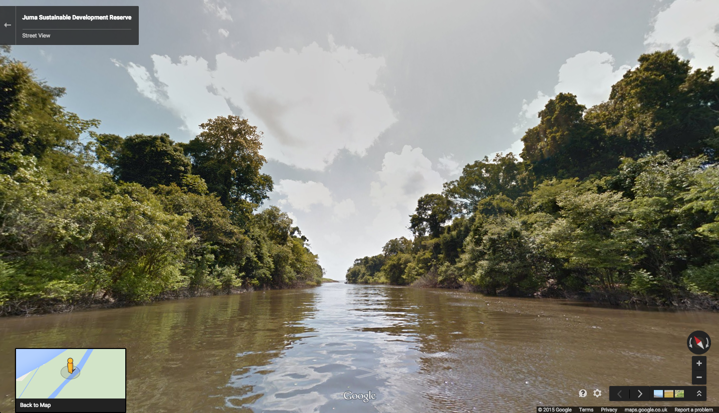
    Rio Mariepauá, Brazil. (Photo credit: Google Maps)
    Rio Mariepauá, Brazil. (Photo credit: Google Maps)
  • Harris Offers Geiger-Mode Lidar Sensor

    Harris Corporation has developed a commercially available Geiger-mode lidar sensor. The Harris IntelliEarth Geospatial Solutions Geiger-Mode LiDAR sensor will provide customers with the ability to collect high-quality, wide-area elevation data faster and more affordably than before, Harris said.

    Additionally, the company’s fully automated, high-volume production capabilities allow for rapid processing of large amounts of raw sensor data and automates quality control. Thousands of square kilometers of data can be processed in a few hours.

    Harris is applying technology and processing methods it has perfected over the past 15 years in support of the U.S. Department of Defense to deliver superior, LiDAR-based data and derived products to commercial users at cost-effective prices, the company said.

    With 10 times the collection speed and resolution of today’s best traditional lidar sensors, the Geiger-Mode lidar sensor makes wide area collections affordable for the first time.

  • Report: Esri Has 43 Percent Share of GIS Market

    ARC Advisory Group reports that Esri has a 43 percent share in the geographic information system (GIS) market, compared to an 11 percent share from the second-largest supplier. ARC Advisory Group published its findings in an October market study and forecast through 2018.

    “Esri is, without a doubt, the dominant player in the GIS market,” the Geographic Information System Global Market Research Study authors stated.

    The Esri business model relies on a constantly improving core GIS, on which more than 2,000 partners develop Esri industry-specific solutions, Esri said. In electricity transportation and distribution, Esri’s partner-driven solution model, which combines Esri and Schneider Electric software, amounts to a total market share of 29 percent.

    “Our success in the utility sector stems from Esri’s platform technology, which makes it easy for companies to share, communicate, and collaborate on location information throughout their businesses,” Esri utilities solutions manager Bill Meehan said. “Partner solutions, such as those Schneider Electric provide, add additional capability to an already powerful platform.”

    Esri’s core GIS is used by more than two-thirds of Fortune 500 companies, helping businesses add a location strategy to operations, Esri said. Esri’s ArcGIS platform has grown during the past 45 years to include cloud, mobile, server, dashboard, and firewall components in addition to desktop applications.

    Partner products target utility-specific issues (such as regulatory compliance or critical-infrastructure management). Partners include Apple, Microsoft, Intel, Oracle, Dell, HP, Citrix, and Lenovo.

    Esri — with its partners — plays a leading role in more than 10 industries: electric power transmission and distribution (with partner Schneider Electric), engineering and business services, government, public health and safety, health care, natural resources, oil and gas refining, retail, telecommunications, transportation and logistics, and water/wastewater.

    Esri is privately held by founders Jack and Laura Dangermond. ARC Advisory Group is a separately owned and operated business and is not affiliated with Esri.

  • Air Pollution Monitoring Rocket Set for Second Launch Attempt

    air_pollution_rocket_blueskyScientists at the University of Leicester will make a second attempt to launch a rocket equipped with air pollution monitoring equipment on June 11 at the university’s Capesthorne Hall in Cheshire. The first launch attempt on Feb. 4 failed, according to airqualitynews.com.

    As part of a wider air pollution mapping project supported by Bluesky, an aerial survey company, a pollution monitoring system was developed by scientists at the University of Leicester to record how dangerous gases such as nitrogen dioxide dissipate with vertical distance from the earth. The micro sensors will be integrated with other technologies and launched into the atmosphere using Starchaser Industries‘ Tempest Research Rocket. The launch follows previous work mapping air pollution across entire cities from planes, cars and ground sensors.

    “We have already had great success mapping air pollution from an aerial survey plane giving us a better understanding of how dangerous gases, such as nitrogen dioxide, operate in the vertical plane,” says James Eddy, Bluesky’s technical director and industrial associate at the University of Leicester. “However, we hope this launch will take air pollution monitoring to another level.”

    The Tempest is a 14-foot-tall rocket that can reach speeds of up to 200 miles per hour and will hit an altitude of 3,000 feet on its flight before being safely recovered via parachute. In addition to the air pollution monitoring sensors, Tempest will also be carrying vital electronic systems that will be used aboard Starchaser’s future Space Tourism Rockets, an experimental GPS package with video cameras.

    “Air Quality continues to be a critical issue in our urbanising society, requiring us to explore novel solutions for monitoring, management and damage mitigation. We are grateful to Starchaser Industries for the opportunity to test our novel air quality monitoring techniques as part of this spectacular launch event,” says Dr. Roland Leigh, academic supervisor at the University of Leicester. “This project builds on work to date of Starchaser Industries, key academic expertise in instrument design and data manipulation, and once again benefits from a strong industrial partnership with Bluesky.”

    The latest phase of the Bluesky supported air pollution monitoring project will add to results already obtained from trials of the University of Leicester’s Compact Air Quality Spectrometer. Originally mounted on a dedicated aerial survey aircraft, the device monitors visible light and measures how much light is lost at specific wavelengths absorbed by nitrogen dioxide. The technology has previously been used as part the CityScan project with devices mounted on tall buildings in Leicester, Bologna and London during the Olympics to build 3D maps of pollution across the cities, according to the company.

  • Meitrack Offers GPS Tracker for 3G Networks

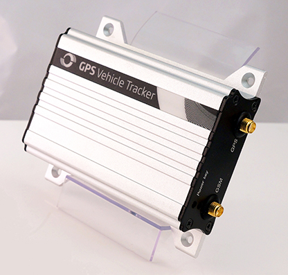
    Meitrack-T1-VEHICLE-TRACKER-WGPS tracking manufacturer Meitrack Group is introducing a tracker that runs on 3G networks. GPS trackers have been running on 2G networks, but soon many wireless carriers will discontinue the outdated 2G technology. Meitrack said it is hard at work making the transition to make all of its current trackers work on the 3G network standard.

    The first model released is the T333 GPS tracker, which offers real-time tracking, history reports, assisted GPS tracking, geofence creation, and an S.O.S. panic button. The tracker can be installed in vehicles ranging from everyday family cars, to construction and commercial trucks.

    The strong outer aluminum casing effectively secures the internal components from exposure to the elements and heat. At 190 grams, the T333 is lightweight and small enough to be securely installed in areas of minimal space, the company said. Meitrack has installed the u-Blox 7 GPS module, upgrading the processing speed and sensitivity. Not only does the T333 GPS tracker run on 3G networks, but it can also run on 2G as a backup if a 3G network is not available.

    The T333 also comes equipped with digital and analog inputs that transform the GPS tracker into a central hub where other accessories can be simultaneously attached and synced. These accessories include fuel sensors, RFID card readers, handset phones, cameras, and even LCDs and LEDs displays.

  • Deadline for ION JNC Abstracts Is Wednesday

    Abstracts are due Wednesday, March 4, for the Institute of Navigation (ION) Joint Navigation Conference (JNC), scheduled for June 22-25 in Orlando, Fla.

    The ION Joint Navigation Conference, sponsored by the ION’s Military Division, is the largest U.S. military positioning, navigation and timing (PNT) conference of the year with joint service and government participation, ION said. The event will focus on technical advances in guidance, navigation and control (GN&C), with emphasis on joint development, test and support of affordable GN&C systems, logistics and integration.

    From an operational perspective, the conference will also focus on advances in battlefield applications of GPS; critical strengths and weaknesses of fielded navigation devices; warfighter PNT requirements and solutions; and navigation warfare.

    For Official Use Only (FOUO), United States only, sessions will be held June 22-24 at the Renaissance Orlando at SeaWorld, Orlando. The U.S. only classified sessions will be held June 25 at Shades of Green Walt Disney World.

    The ION JNC features more than 200 operational presentations on a diverse array of topics. Abstracts are being accepted through March 4.

  • ASPRS Releases New Accuracy Standards for Digital Geospatial Data

    The American Society for Photogrammetry and Remote Sensing (ASPRS) has released new Positional Accuracy Standards for Digital Geospatial Data. The PDF is available here.

    The new ASPRS accuracy standards fill a critical need for map users and map makers alike. For centuries, map scale and contour interval have been used as an indication of map accuracy. Users want to know how accurately they can measure different things on a map, and map makers want to know how accurate maps need to be in order to satisfy user requirements. Those contracting for new maps depend on some form of map accuracy standard to evaluate the tradeoff between the accuracy required vs. how much time and expense are justified in achieving it, and then to describe the accuracy of the result in a uniform way that is reliable, defensible, and repeatable, ASPRS explains in a statement.

    The new ASPRS standards address recent innovations in digital imaging and non-imaging sensors, airborne GPS, inertial measurement units (IMU) and aerial triangulation (AT) technologies. Unlike prior standards, the new standards are independent of scale and contour interval, they address higher levels of accuracies achievable by the latest technologies (such as unmanned aerial systems and LiDAR mobile mapping systems), and they provide enough flexibility to be applicable to future technologies as they are developed. Finally, the new standards provide cross references to older standards, as well as detailed guidance for a wide range of potential applications.

    No prior U.S. accuracy standard comprehensively addresses the current state of mapping technology, which is why the new ASPRS standards were developed. The National Map Accuracy Standards (NMAS), developed in 1947, are still used because they are simple, but there is no scientific correlation between those standards and current mapping methodologies.

    The ASPRS 1990 Standards were an improvement over NMAS; however, they did not do well in representing the capabilities of LiDAR, orthoimagery, digital mapping cameras or other current technologies in wide-spread use today.

    The National Standard for Spatial Data Accuracy (NSSDA) is a reporting standard that references the old ASPRS 1990 standards and is cross-referenced in the new ASPRS standards.  NSSDA provides no accuracy thresholds and does not by itself provide any new or updated guidance on how to select or specify an appropriate accuracy for intended applications.

    The new ASPRS standards were developed by the ASPRS Map Accuracy Standards Working Group, a joint committee under the Photogrammetric Applications Division, Primary Data Acquisition Division and LiDAR Division, which was formed for the purpose of reviewing and updating ASPRS map accuracy standards to reflect current technologies. A subcommittee of this group, consisting of Qassim Abdullah, David Maune, Doug Smith, and Hans Karl Heidemann, was responsible for drafting the document.

    Draft versions of the standard underwent extensive review, both within ASPRS as well as through public review by other key geospatial mapping organizations, prior to final approval by the ASPRS Board of Directors on November 17, 2014.

  • MWC 2015: Geotab Offers Add-On Extender for All-Vehicle Support

    Geotab, a telematics engineering company, has released its IOX-CAN extender, a plug-and-play solution that allows partners to send data from their device over a private CAN network in the vehicle, supporting integrations on all vehicle types.

    Geotab is exhibiting at Mobile World Congress 2015, at Hall 3, Stand 3J20.

    According to Geotab, Fortune 500 companies, including 40 percent of the top ten fleets and 18 percent of the top 100 fleets in North America, rely on Geotab’s solutions to improve productivity, optimize fleets through the reduction of fuel consumption, enhance driver safety, and achieve stronger compliance to regulatory changes.

    A number of companies are already leveraging the IOX-CAN extender to send data from their devices to the MyGeotab system. Geotab’s integration with Mobileye, a technology company that develops vision-based Advanced Driver Assistance Systems (ADAS) providing warnings for collision prevention and mitigation, has been upgraded with the IOX-CAN extender allowing full support for all vehicle types, including OBDII (on-board diagnostics II) vehicles.

    Geotab’s new add-on solution allows Mobileye devices to plug into Geotab’s GO6 and GO7 devices, allowing Mobileye data to be sent to the MyGeotab software platform, where it can be viewed and analyzed by dispatchers and fleet managers.

    “Our solutions are designed to make the roads safer for everyone as the issue of distracted driving continues to be a problem,” said Elad Serfaty, vice president and general manager of Mobileye Aftermarket. “Working with Geotab allows us to not only provide feedback to the driver, and with managers who can effect change where needed, but we can do this across all vehicle types.”

    “Expanding our integration capabilities and continuing our work with Mobileye is a natural evolution as more and more companies realize the benefits of fleet management,” said Neil Cawse, CEO, Geotab. “Providing collision warnings to drivers just before a crash is the first step to creating a safer driving environment for everyone.”

  • Agency9 Brings WebGL Streaming of 3D Cities to iOS and Android

    Agency9-2

    Agency9, a provider of online 3D visualization, is extending its 3DMaps WebGL support to iOS and Android devices. Large, highly detailed 3D city models can now be streamed to web browsers on both tablets and smartphones with both high performance and visual quality, the company said.

    Mobile support substantially improves reach in GIS and planning applications, Agency9 said. Using WebGL and HTML5 improves usability with plugin-free viewing of 3D directly in a web browser, eliminating the need to download and install dedicated apps.

    Most WebGL 3D solutions on the market are pure “model viewers,” limited to show a CAD model and its closest surroundings or simple untextured LOD 1,2 models. Agency9 3DMaps is capable of smoothly visualizing large scale terrain and detailed textured building models on a national or global basis. For example, huge photorealistic 3D models created with tools such as Smart3DCapture by Acute3D, recently acquired by Bentley Systems, can now be published online using WebGL without limitation in size or resolution, the company said.

    Agency9 3DMaps supports common 3D scenery in common GIS formats (including ArcGIS and CityGML) and is also validated with output from tools as Smart3DCapture, PhotoScan from AgiSoft, and StreetFactory from Airbus Defence and Space, as well as LiDAR/imagery tools from TerraSolid.

    Agency9-1

    The Agency9 3DMaps developer platform enables the customization of portals as well as integration into existing applications to leverage ubiquitous support for streaming large 3D data to users across all formats including tablet, mobile, Windows and MacOS.

    Rendering substantial 3D data sets in the browser using 3DMaps with advanced gaming effects such as ambient occlusion, real time sun and shadows, and god rays ensures the finest realism and user experience, the company said. 3DMaps also supports integration of spatial data and databases for intelligent models and visualisation of statistics. Visit the 3DMaps developer portal at http://developer.agency9.com.

    Mobile support will also be available in Agency9 CityPlanner, the cloud service for creating and sharing 3D project information and citizen dialogues in urban development. Smart Cities can more easily reach citizens and stakeholders on the web with interactive visualisation of projects in 3D. An example of a large project model created in ESRI CityEngine and visualized in the huge photorealistic 3D scene above.

    Photos: Agency9

  • MWC 2015: RAD Demonstrates IEEE 1588 Grandmaster

    RAD-grandmaster-MiCLK
    Photo: RAD

    Telecom company RAD will be expanding the timing synchronization capabilities of its Service Assured Access (SAA) solution when it introduces MiCLK, an IEEE 1588 grandmaster clock with a built-in GNSS receiver.The grandmaster clock is SFP-based (small form-factor pluggable).

    RAD is demonstrating the MiCLK at Mobile World Congress 2015, being held this week in Barcelona, Spain.

    “LTE and LTE-A’s stringent synchronization requirements and the growing use of small cells in 4G networks create synchronization challenges in the backhaul segment, but existing solutions are either too expensive or do not provide full network coverage,” said Ulik Broida, RAD’s vice president of marketing and business development. “With the revolutionary MiCLK, RAD makes it easy to upgrade existing backhaul networks to support LTE-A at an affordable price.”

    Many network operators prefer to use IEEE 1588-2008 (also known as Precision Time Protocol, or PTP) and synchronous ethernet to deliver accurate frequency and time throughout 4G backhaul networks. They are reluctant to install GNSS at every cell site because of practical and cost reasons, as well as concern about possible GNSS jamming and spoofing. However, accurate time distribution requires every network element between the time reference — the grandmaster — and the cell site to support IEEE 1588. This could be an expensive and complex endeavor when the grandmaster is located in a central PoP. “MiCLK allows network operators to avoid costly upgrades by bringing the grandmaster to the base station,” said Broida.

    RAD’s patent-pending MiCLK is a miniature pluggable device that responds to the needs of next-generation cellular backhaul networks, the company said. Its SFP design allows simple installation to upgrades any network device with a fully featured IEEE 1588 grandmaster, including a GNSS receiver and various redundancy options to sustain its operation in case of GNSS failure, RAD said.

    “Easily installed with minimal technical intervention, MiCLK is a versatile add-on anywhere in the network,” Broida concludes. “It is a valuable addition to mobile equipment vendor portfolios, and an ideal solution for 4G service providers in search of a quick, cost-effective way to bring accurate synchronization to small cell backhaul.”

    RAD  is exhibiting at Hall 2, Stand 2D50 at Mobile World Congress.


  • MWC 2015: Rx Networks Updates GNSS Extended Ephemeris Solution

    Rx Networks Inc., a mobile location technology and services company, announced the upcoming release of its GPStream PGPS v8 extended ephemeris solution at Mobile World Congress 2015, taking place this week in Barcelona, Spain.

    The patented technology, being used in hundreds of millions of devices, is designed to speed up the time-to-first-fix (TTFF) of any GNSS chipset while improving acquisition sensitivity in challenging environments.

    Compared to the previous version, GPStream PGPS v8 effectively doubles accuracy performance while supporting all four global GNSS constellations. GPStream PGPS v8 will be available for integration testing in the second quarter of 2015, with commercial release in the fourth quarter of 2015. (Full commercial support for Galileo will remain subject to the readiness of the constellation).

    All major GNSS semiconductor vendors are now offering or developing multi-constellation support to improve availability in challenging environments. Quad-constellation support also enables OEMs and GNSS chipset manufacturers to meet any national or regional market requirement. Availability of extended ephemeris across the four constellations is required to ensure fast TTFF and optimal sensitivity. Early lab access to the latest GPStream PGPS v8 solution from Rx Networks can help chipset manufacturers validate performance early in the development cycle and thus accelerate the time to market for their new multi-constellation chipsets.

    A key component of any extended ephemeris solution is the accuracy of the orbit and clock predictions. This accuracy is often presented as an error in meters compared to the native broadcast ephemeris transmitted by the satellites. The latest version of GPStream PGPS improves this accuracy by a factor of two, compared to its previous release. For example, day 1, 7 and 14 accuracies for GPS are now 2.8 m, 4.5 m and 11.4 m compared to 6.3 m, 12.5 m and 30.2 m previously. BeiDou and Galileo will experience similar performance. GLONASS is also significantly improved, with day 1, 7 and 14 accuracies of 1.8 m, 6.5 m and 13.7 m compared to 7.3 m, 13.4 m and 27.2 m previously.

    “Rx Networks continues to expand its relationships with major OEMs and GNSS chipset manufacturers to help them deliver innovative, multi-constellation and highly accurate GNSS performance,” said John Carley, senior product manager at Rx Networks. “This latest release reaffirms our commitment to provide best in class Assisted-GNSS solutions for the mobile market.”

    Rx Networks is exhibiting in Booth 5H75 at Mobile World Congress.