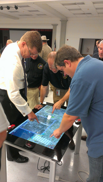
Two new apps developed at Texas A&M University-Corpus Christi use social media to help police officers, news stations, and the public navigate the many incidents and minor emergencies that may occur on a daily basis.
Richard Smith, creator of the two emergency response apps, is collaborating with Michelle Maresh-Fuehrer, assistant professor of Communication at A&M-Corpus Christi, to identify how the apps could aid first responders during emergencies.
“With the combination of SituMap and PhotoSorter, the public can be encouraged to submit photos and videos that may be helpful during an investigation,” said Smith, assistant professor of Geographic Information Science and Geospatial Surveying Engineering at the Island University. “For example, during an active shooter event, photos and videos of the suspect or their location can be taken with a cell phone and easily sent to responders. This could drastically improve response time and ultimately save lives.”
Photo credit: Texas A&M
Smith developed the mapping applications to provide a way for first responders to rapidly, and easily, receive and map information so they could have a more comprehensive awareness of emergency situations. Maresh-Fuehrer is working on extending the use of Smith’s social media mapping applications to enhance communication before, during, and after a crisis.
“A crisis event is typically a time of high stress and increased uncertainty for organizations and responders,” said Maresh-Fuehrer, who studies crisis communication strategies. “The applications developed by Dr. Smith have several features that allow for more informed and efficient crisis response.”
SituMap acts as a tablet-like digital command center that shows officers maps of the crisis area. With the touch of a finger the table-size display can be zoomed, rotated and drawn on. Like a personalized version of Google Maps, officers can search for locations and measure distances. But it goes further than Google Maps. A pin can be created in the application that could represent a person, police car, or groups of people. The pin can be strategically positioned around the area and directions can then be relayed to officers at the emergency location.
“An organization’s crisis team, along with emergency responders, can use SituMap to identify where people should be during a specific crisis,” said Maresh-Fuehrer. “With this application, responders can even view floor plans. This could help to identify safe locations such as fire exits and stairwells.”
PhotoSorter works in tandem with SituMap by allowing emergency responders, crisis planners and community members to share pictures or video of the crisis. Emergency responders can then upload the photos and video into SituMap to help in important decision-making situations.
SituMap and PhotoSorter were designed and developed at the Island University by Smith. The University Police Department is currently using a beta version of SituMap in training sessions.
In today’s digital world, people all over the globe can be connected through social media and, with the touch of a button, information about a major accident can be shared worldwide. With SituMap, important responders, as well as the community, can see real-time information on traffic congestion, roadblocks, and closed roads, which will aid in faster response times. The app also has a weather feature built into it which could be used during severe weather events such as a hurricane.
Lawyers for 11 Pennsylvania residents injured in 2013 when their charter bus slammed into an overpass in Boston, Mass., are suing GPS device manufacturers TomTom and Garmin, seeking more than $15 million in damages.
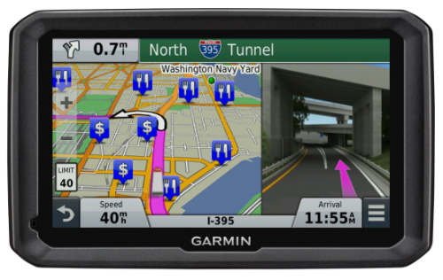
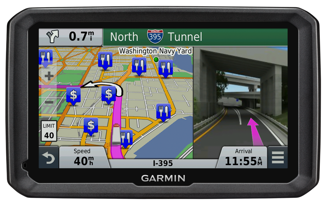
The bus driver was using both a Garmin and a TomTom satnav, neither of which were intended for use by commercial vehicles, but the lawsuit filed in January claims that the GPS units were at fault for not providing road height restrictions.
The bus driver, Samuel J. Jackson, told police he drove the 11-foot-high bus onto Soldiers Field Road, which is off-limits to vehicles more than 10 feet high, because he was “following the GPS.” At least one sign warning of this restriction was missing or damaged, and construction on the Harvard Street overpass obstructed other warning signs, the suit said.
Passengers were injured when the bus roof crushed backwards in the crash dropping the luggage rack and television onto the heads of the passengers, the Boston Globe reports.
Both TomTom and Garmin manufacture GPS units for professional drivers which feature information on bridge underpass height restrictions.
The new RX520 dual-frequency GNSS receiver from TeeJet Technologies brings reliable, upgradable accuracy and performance to precision farming applications, TeeJet said. It features an integrated L1/L2 GPS+GLONASS receiver and antenna in a single compact enclosure. Integral magnetic mounting allows for a clean, low-profile installation.
All RX520 receivers include ClearPath technology, which ensures smooth, consistent position data even if brief signal losses occur. The standard L1/L2 SBAS receiver offers +/- 5-8 in pass-to-pass accuracy for a wide variety of field operations. Optional precise point positioning (PPP) provides improved +/- 2-4 in pass-to-pass accuracy and year-to-year repeatability, making it suitable for strip-till and other high-precision operations. PPP accuracy is delivered via TerraStar subscription signal and is offered in 1-, 3-, 6- and 12-month packages.
“This is a very versatile receiver that is compatible with TeeJet and many third-party guidance and auto steer products,” said Tim Stuenkel, global marketing manager with TeeJet Technologies. “Another great feature is the ability to pay for only the accuracy you need today, with the flexibility to upgrade to higher performance down the road as your needs change.”
TeeJet Technologies manufactures a comprehensive line of products including agricultural spray nozzles for various pesticide/fertilizer applications, boom components, valves/manifolds, strainers, and spray guns, as well as GPS guidance systems, sprayer control systems, ISOBUS job computers, assisted steering systems and other precision farming products. In addition, TeeJet Technologies continues to invest in research and development to advance precision application and control technology.
Antenna maker Maxtena has launched an L1 L2 GPS/GLONASS active helix antenna for GNSS satellite applications. The new antenna M1227HCT-A2-SMA antenna will replace its predecessor the M1227HCT-A-SMA antenna, which made its debut in 2010.The new antenna has been mechanically upgraded. It is packaged in a high-quality, durable IP67/68 sealed radome housing and terminated with a gold-plated SMA connector for RF feed/input and DC bias/power typically powered from the applications’ GNSS RF module.
The M1227HCT-A2-SMA active helix design features Maxtena’s patented compact and light-weight Helicore Quadrifilar antenna technology and a built-in dual-stage low noise amplifier (LNA) and filtering, offering up to 30-dB gain for GNSS applications that use GLONASS and GPS in one radome housing with a single 50-Ohm SMA connector.
The tiny antenna is designed for applications across various markets such as UAVs, GIS and wearable GNSS.
ClearTerra‘s Jeff Wilson gives a snapshot of the company’s Locate XT software while at the 2015 Esri Federal GIS Conference, held Feb. 9-10 in Washington D.C. The LocateXT software extracts unstructured textual documents into structured spatial output for GIS and spatial viewing platforms, including Esri ArcGIS and Google Earth.
The German Galileo test and development infrastructure GATE has been recertified to serve as a Galileo open‐air test laboratory, for receiver integrity testing (RAIM) for safety‐of‐life (SoL) applications, and for Galileo SIS ICD conformance of signal characteristics and signal quality.
The GATE facility, in Berchtesgaden, is operated by IFEN GmbH. Certification was conducted by TÜV SÜD, an international service corporation focusing on consulting, testing, certification and training.
GATE consists of eight transmitting stations that emit Galileo signals in the GATE test area in Berchtesgaden, as well as two monitoring stations that receive and process these signals.
For application tests, it is essential for GATE to provide constant Galileo specifications for tests, including position accuracy, signal spectrum and navigation data. This is necessary for both test types: tests with the eight “GATE satellites” only and tests with simultaneously usage of the already-existing Galileo satellites in orbit.
The compliance to the specification was verified by the company NavCert GmbH from Braunschweig, Germany, in a recertification of the GATE test bed. Compared to a full certification, taking place every three years, a recertification only verifies the compliance to the specification by the use of random inspections though tests in GATE.
The recertification also includes an audit of the operation processes of the operating company IFEN GmbH. Here, the implementation and adherence to process procedures for GATE operation were verified. This includes questions such as whether a sufficiently technical skilled team is available for operating GATE, if the performed application tests are documented in a reproducible way, and how the GATE team handles non‐conformances to the specification and improvements to the system.
With finalization of the recertification work, the GATE certificate was extended by TÜV SÜD to January 2016. Because of this, GATE customers can rely on the independent verification of the GATE test and development environment for upcoming testing activities, IFEN said.
As an add‐on, customers of IFEN’s NavX‐NCS GNSS simulator benefit from the recertification by obtaining a confirmation from an independent organization (TÜV Süd), reassuring the functionality of GPS and Galileo signal characteristics and signal quality as per SIS ICD, IFEN said.
Esri Managed Cloud Services (EMCS) has achieved Federal Risk and Authorization Management Program (FedRAMP) compliance at the moderate level, Esri president Jack Dangermond announced during the Esri Federal GIS Conference in Washington, D.C.
EMCS is the first program tailored specifically for a GIS to offer a cloud environment compliant at the FedRAMP moderate level, meaning it satisfies the stringent security requirements that federal agencies must meet before operating in a cloud computing environment.
“We look forward to continue working with vendors like Esri who have demonstrated FedRAMP compliance through the CSP Supplied path,” said Matt Goodrich, FedRAMP director. “This approach facilitates federal agency security authorization demands as the complete security package for Esri Managed Cloud Services is available in the FedRAMP repository today.”
EMCS provides ready-to-use instances of ArcGIS in the cloud. Customers can adapt it to best suit their needs, either as an alternative in their own infrastructure or in conjunction with their own servers. The scalable, secure environment is supported by experienced GIS professionals to ensure GIS data and services are available whenever needed, Esri said.
FedRAMP is a government-wide program that provides a standardized approach to security assessment, authorization, and continuous monitoring for cloud products and services. Being FedRAMP compliant means a cloud computing system has established and documented a highly secure environment that has withstood comprehensive, rigorous review before federal agencies are authorized to engage the system. Currently, compliance can be met at either the low or moderate level.
EMCS is the first geospatial cloud-service provider reviewed under the latest FedRAMP and NIST 800-53 Revision 4 security controls. This expanded set of security controls represents the most comprehensive update to the government security controls catalog since its inception in 2005 to better address the increased frequency and persistence of today’s cyber attacks.
With Esri Managed Cloud Services, customers can use ArcGIS Online, Esri’s online GIS platform, as their primary discovery mechanism and easily supplement it with Esri’s FedRAMP-compliant GIS hosting tools, ArcGIS for Server and Portal for ArcGIS, to meet more advanced security needs. The program provides a standardized, demanding security protocol that customers can review themselves and that federal agencies can use for the government assessment and authorization process to expedite compliance.
EMCS also supports federal agencies seeking to comply with the White House Cloud Computing Strategy. Adopted in 2011 to save money, the Cloud First policy requires federal agencies to evaluate safe, secure cloud computing options before making any new investments.
Because EMCS was designed from the ground up to meet the needs of federal customers, it can also meet the robust security demands of users from other sectors such as law enforcement, health care, and retail, Esri said.
GIS users are moving to the cloud in large part to take advantage of the flexibility and potential cost savings it provides. Using EMCS helps users reduce risk, speed deployment, improve performance, and reduce operational costs in a secure environment.
PD Ports is streamlining the way it shares hydrographic data by using GIS software from British software developer Cadcorp. PD Ports is a port, shipping and logistics company headquartered in Middlesbrough, UK, where it owns and operates Teesport — a major deep-water complex and one of the largest container ports in the North of England.
Teesport is a major deep-water complex and one of the largest container ports in the North of England, handling around 40 metric tons of cargo per year, according to Captain Jerry Drewitt, Harbor Master for Teesport and Hartlepool. “Our first priority is to ensure the safe movement of the considerable amount of river traffic handling this cargo. We rely a lot on hydrographic survey charts which provide an up-to-date record of the depth of the river in berths, approaches, and channels.
“Until recently, our survey department not only carried out hydrographic surveys, but also produced the associated charts. This is changing as we have come to recognize that having surveyors spend time on creating cartography was an unnecessary step in the sharing of hydrographic data, and was actually delaying data publication.“
Drewitt continues, “Hydrographic charts don’t only depict depth data. They also show topography and contextual data about features and boundaries along the river. The position of these features and their attributes, tend to be relatively stable — certainly when compared to the constantly changing topography of the riverbed. We wanted the survey department to concentrate on recording this more dynamic hydrographic data.”
“The less dynamic data — topography, assets, boundaries, Admiralty Charts, Ordnance Survey MasterMap, and aerial photography — can be managed as separate overlays in our GIS, Cadcorp SIS Map Modeller,” Drewitt said.
“We now create composite hydrographic charts by displaying the hydrographic data the surveyors capture, against whatever reference layers are appropriate for a task in hand,” Drewitt said. “This is done in the knowledge that all features will be represented in their true location. We now take XYZ soundings directly from the survey department; drag and drop this data into the Cadcorp GIS, and pass it through a simple filter to indicate three categories of depth zones. Red indicates where the river is too shallow, blue where it is OK, and white where it too deep. “
The outcome of these changes allows the harbor master to share information with the Vessel Traffic Service and pilots much more quickly than before. For example, whenever there is suspected slippage in the river bed, the survey department can be alerted to make a new survey of the affected area. The outcome of their echo-soundings will exported as XYZ files to Map Modeller. The GIS is used to delineate any areas which are deemed to be out of bounds. It is then a simple matter to insert a map into a Word document as a “Shoaling Notice” that can be distributed by email.
Drewitt hopes his deputy harbor masters and pilots eventually will be able to accept map data from Teesport directly in digital form and in real time. However, for the moment, GIS is playing a transitional role somewhere between a map creator and a map viewer. This can be seen in current project where Captain Drewitt is using GIS to match vessels to available berths. He uses the GIS to create and display templates of vessels originally designed as DWG files in AutoCAD. By superimposing these templates, along with tugs and towlines, over maps and charts, it becomes possible to assess the maximum size of vessels that can be accommodated in different berths.
“It is easy to generate a family of templates, and a simple matter to superimpose them against maps,” Drewitt said. “While I can’t yet share them online, I can take map representations to meetings, where the serve an important evidential role.”
“GIS applications don’t have to be complex to deliver real business benefit,” said Mike O’Neil, CEO of Cadcorp. “Teesport have shown this. Their use of GIS isn’t about intricate analysis and modelling. On the contrary, it is about the value you get by bringing together different data sets, quickly and easily. The combined value of these different data sets is often much greater than the sum of its parts.”
The Coalition of Geospatial Organizations (COGO) has released its Report Card on the U.S. National Spatial Data Infrastructure (NSDI), and given the NSDI a C- grade. The NSDI aims to promote sharing of geospatial data throughout all levels of government, the private and non-profit sectors, and the academic community.
“Federal agencies have worked for many years to improve their geospatial programs, but the COGO member organizations believe that the national data sets and delivery systems (the NSDI) generally need improvement,” said Michael Vanhook, COGO chairman. “It is time for the federal government to more effectively engage the entire stakeholder community to ensure that America has the highest quality geospatial infrastructure. Doing so will allow us to more efficiently and effectively deal with society’s needs, and to reduce duplication of effort.”
The Executive Summary of the report calls out the need for greater data sharing between government and the private sector.
“The federal government jump-started many of the innovations and collaborations that create the current geospatial environment. However, as noted in the 2009 National Geospatial Advisory Committee (NGAC) report ‘The Changing Geospatial Landscape,’ the federal government is no longer the dominant data producer. Federal providers of geographic information cannot continue to think of themselves as players separate from the community of private sector, state, local, tribal, and other stakeholders…
“The relative shifts in data production from the federal government to the private sector and state and local government call for new forms of partnership. Furthermore, the hodgepodge of existing data sharing agreements are stifling productivity and are a serious impediment to use even in times of emergency. There is an urgent need to reexamine the relationships between data providers and users to establish a fair and equitable geospatial data marketplace that serves the full range of applications.”
According to the Executive Summary, “The Expert Panel concludes that the Framework requires attention, and that several actions need to take place.
The concept of the Framework needs to be reaffirmed.
A new model for Framework data needs to be adopted, and this new model must acknowledge the importance of local partners.
The Federal Geographic Data Committee (FGDC) needs to emphasize that the Framework is part of its Strategic Plan, and that it will work in collaboration with non-federal and non-governmental partners to build an effective NSDI Framework.”
As stated in the report’s foreword, COGO “recognizes the individual contributions of all federal, state, regional, tribal, and local government agencies that have worked in concert with the private and academic sectors to develop the National Spatial Data Infrastructure (NSDI) as it exists today. This work has spanned entire careers, and COGO applauds the sincerity of their efforts and the value of their contributions.”
COGO represents 170,000 individual geospatial practitioners. “Together, the coalition is delivering this assessment to help Congress, the administration, federal agency executives, and others understand the importance of geospatial data to the nation, as well as shortcomings of the NSDI,” COGO said in a statement.
Anthony Gage from Canon Solutions America details the Océ ColorWave 650 at the 2015 Esri Federal GIS Conference, held Feb. 9-10 in Washington, D.C. The machine can print up to 1,300 square feet per hour in both black and white and color. It can hold up to six media rolls, and prints come out dry and cut to size.
The long-anticipated 2016 President’s Budget (PB) was submitted to Congress in early February. The PB is the spark that ignites the lengthy and often contentious congressional budget process, including: adopting a budget resolution framework, developing numerous discretionary spending bills, reconciling legislation between the House and Senate, approving continuing resolution stop-gap measures and finally, hopefully, appropriating funds for various programs — including the Global Positioning System (GPS) as part of the Department of Defense’s (DoD’s) U.S. Air Force (USAF) budget request.
For FY (Fiscal Year 1 Oct – 30 Sep) 2016, the U.S. Air Force requested a topline budget of $122.2 billion in Air Force controlled funding that exceeds funding levels recommended by the OMB (Office of Management and Budget) and laid out in the Budget Control Act by almost $10 billion. Several well-meaning friends still in high places in the government immediately sent me copies of the USAF budget while it was still warm, so to speak, and thought that I would be “properly incensed” — proffered one old friend — over the so-called $10B overdraft. I hate to disappoint my friends, but in the spirit of the USAF policy of putting the Bottom Line Up Front, I applaud the Air Force action and personally think it may be too little, too late. The supplemental request or overdraft should probably have been more on the order of $20B, not $10B.
Hollow Force
This is not an emotional reaction, but a reasoned statement by a seasoned veteran airman of 30 years in the USAF, yours truly, who served through at least two periods of a “hollow force” that were devastating not only to the USAF as an institution, but to the DoD as a whole and to all the personnel who served during these austere and dangerous times. And, yes, I am equating a hollow force with a dangerous force. Indeed, the term “hollow force” officially refers to military and government forces that certainly, on the surface, appear to be “mission ready,” but upon close examination suffer from moderate to severe shortages of personnel and equipment as well as deficiencies, to varying degrees, in training.
Gen Mark A Welsh III, Chief of Staff, USAF, testifying before the Senate Armed Services Committee 201 (Photo courtesy of USAF – SSG Sean K. Harp).
In recent testimony before the Senate Armed Services Committee, along with his fellow service chiefs, General Mark A. Welsh III, chief of staff of the United States Air Force, laid out the dangers inherent in the hollow force when he stated:
“Last year, our readiness levels reached an all-time low. As we struggle to recover, we don’t have enough units ready to respond immediately to a major contingency, and we’re not always able to provide fully mission-ready units to meet our combatant commanders’ routine rotational requirements.
“The Air Force’s modernization forecasts also are bleak. About 20 percent of [our] aircraft flying today were built in the 1950s and 1960s, and more than half of the rest are 25 years old or older.
“And now, due to sequestration, we’ve cut about 50 percent of our currently planned modernization programs.”
To someone who lived through the hollow force in the past, this is a scary description and prospect for our airmen. In describing the results of budget cuts and difficult decisions regarding program terminations that result in a hollow force, General Welsh put it this way:
“Without these tough calls, the Air Force ‘will be neither ready to fight today, nor viable against the threats of tomorrow’.”
Indeed, a hollow force puts every ones lives in danger. During the post-Vietnam hollow force created by the peanut farmer, there were times when there were B52 aircraft sitting alert just for the spy satellite photo ops that did not have engines in the nacelles nor certified crews to fly them. Aircrews were lucky if they were able to fly four hours per month, and believe me, that made us all less than proficient. I remember one incident specifically. My oxygen (O2) mask had failed on a previous flight and I needed a new one. In the high-performance aircraft in which we flew, regulations required an O2 mask be attached to our helmet and actually in place with crewmembers in the cockpit breathing pure (100%) O2 above a certain altitude. Because of budget cuts, I was issued a waiver, a piece of paper that said I was legal to fly without a fully functioning O2 mask. Fortunately I never was forced to fly without a fully functioning O2 mask, but what if I had been? What if I had passed out from O2 deprivation? What about the other members of the crew? What purpose did the piece of paper serve, other than mollifying a paper pusher’s conscience? Would the Air Force crash investigators have found it in the wreckage and said, “Oh, it’s OK, he had a waiver!” These are the types of things that can happen with a “hollow force.” We don’t need to go there again, and if nothing else, the extra $10B may be just the ticket to keep the aircrews proficient and equipment maintained.
The Color of Money
I know that budgeting and spending other people’s money seems like a simple issue, but with the government, nothing is ever simple. Consequently, the DoD has established an entire university system, known as the Defense Acquisition University (DAU), to train acquisition, program and financial officials in handling government acquisition funds, along with other procurement activities. Under the Budget Control Act guidelines and the Congressional cost-cutting exercise known as Seques-castration, 2016 is another cost-cutting year. That is significant when you understand that the USAF and all of DoD are still reeling from more than ten years of war, on more than one front, along with previously mandated significant budget and manpower cuts that seriously impacted the ability of the USAF to accomplish its multitude of missions.
Consider that budget cuts have a lingering, insidious and costly effect in equipment not maintained or replaced, training not accomplished, R&D not conducted, new technologies not developed, and inevitably the inability to accomplish the mission. A lot of the complexity in these budget-cutting moves relates to what the government refers to as the color of money. For example budgetary funds are appropriated and obligated for the USAF, and most other services, according to the following formula:
O&M – Operations and Maintenance – Obligated for 1 year
MILPERS – Military Personnel – Obligated for 1 year
RDT&E – Res Dev Test & Eval – Obligated for 2 years
PROC – Procurement – Obligated for 3 years
MILCON – Military Construction – Obligated for 5 years
As you can see, all funds are not obligated for just one year and then the money expires. Indeed, there are several colors of money, and failing to fund an RDT&E effort can have catastrophic results on the future of that program and associated programs that might benefit from the technology not developed. At any one time, the USAF is juggling budgets stretching across years and programs and moving money or robbing Peter to pay Paul.
FM (Financial Management) or financial and program management gurus at any one time are managing funds that originated as many as five years previously, plus the current year’s budget, while planning on how to use funds that might carry over to next year. They have just submitted the FY16 budget, which also means they are now hard at work on the FY17 budget without knowing what will be obligated for FY16. Across all those budget years, they have to deal with the arcane rules concerning the color of money. Yes, they are professionals (I’ve been married to one of the best for 35+ years), and they do a great job, but face it — sometimes they are just taking a well-educated guess and hoping for supplemental funding just to meet basic requirements.
Seriously, FM’ers live for the fairytale that one day a combatant commander will say, “Hey, your mission is more important than mine, so I will ‘MIPR’ (a one-time financial move) my funding to your budget line for your project.” Let’s see — a pig is not aerodynamically designed to fly…
Space
Funding for all space programs is especially critical, as the entire space arena is known as a force multiplier, in that satellites and space platforms provide and enable capabilities that increase the effectiveness and reach of all military and government personnel. Therefore, when space programs are not funded, delayed or are cut, the impact ripples across the entire DOD. This is especially true of GPS and PNT (Position, Navigation and Timing) systems which have become so ubiquitous, they are considered a must-have utility for billions of users around the globe, not just the U.S. government. In fact, military and government users may be the smallest segment of users for GPS and PNT services today, which is ironic when you consider that, as General John Hyten (USAF), commander of Air Force Space Command, loves to remind us, “GPS is provided to the world, and over three billion plus users, free of charge 24/7, by the United States Air Force.”
OCX – Next-Generation Space Control Segment
Unfortunately, a couple of major GPS-related programs are in trouble. For OCX, the Next-Generation Control Segment for GPS, my sources tell me, and 2016 budget documents clearly show, that current costs attributable to the prime contractor greatly exceed the contract award specification of ~$886M by a factor of 100% ,with a delivery date still far out on the horizon — somewhere around 2020 with a total program costs of $3.6B. That’s the bad news; the good news is there are definitely sound alternatives, and my sources tell me they are being belatedly explored.
Sometimes the behemoth primes are just that: too big and too expensive. Oftentimes the real subject matter experts (SMEs) reside in the smaller, boutique, more agile companies that can do the job in 24 months for $200M, which is a price that was quoted to me recently by a company with skin in the game, since their software products are responsible for launching and controlling all of the GPS satellites launched in the last eight years without a single failure. Plus, sources inside the company tell me that they have already developed a complete launch and initial checkout system for GPS III, which the OCX prime contractor is still struggling to construct.
This is where the USAF and OSD must step back and assess the OCX program for all its merits versus costs. GPS is not that complicated a satellite system, and yet we are on course to spend $3.6B for a ground C2 (Command and Control) system that will still have significant shortcomings. If it were the perfect C2 system in the end, that would be one consideration, but in fact, as the prime has admitted, it will be far from what was initially envisioned, and the total program costs will have grown by almost 400%.
This scenario begs the question: As the GPS acquisition authority, which product would you trust, a known product derived from a proven government and commercial satellite launch and C2 capability in operation today from a reliable company that has a flawless track record of GPS launches for the last eight years? Or a brand-new unproven product costing billions of dollars from a company that is clearly struggling technically and financially and has, at the end of the day, never launched or controlled a single GPS satellite? The answer seems clear to me. Obviously, there are valid alternatives, and in this budget environment the USAF needs to take a look at replacements, alternatives, supplements and backups, however you choose to phrase it, to OCX.
As we were going to press, we learned that Mr. Kendall has given the OCX Program a green light, but with several caveats indicating the program will be closely watched in the future. Mr. Kendall confirmed that while the OCX costs had indeed doubled, he was going to stay the course for now.
Major General Roger Teague, director of space programs for the Air Force acquisition chief, said a review by chief arms buyer Frank Kendall went well, but program officials and the contractor got “tough marching orders” to stick to schedule and cost targets. That is well and good, but history shows us that it has never happened in the past with the OCX program, and so some tough changes are going to have to be made if they are going to stay on track. We wish them well.
GPS III – Next Generation Space Segment
On the satellite or hardware side of the house, the GPS III — or next-generation GPS satellite — is also having problems, but in this case it centers on development and delivery issues with a subcontractor having serious technical issues and who has failed to deliver on cost or schedule. That subcontractor was just last week bought by a bigger prime, so we will have to wait and see what happens. In this case, however, the whole satellite program is not failing just a component, albeit an important one, the Mission Data Unit or MDU. Although again the answer seems simple, there are bigger forces at play, and one of them is wrapped up in a new government initiative known as Better Buying Power 3.0.
Better Buying Power 3.0
The current GPS III+ budget input states: “In an effort to implement Better Buying Power 3.0 (BBP 3.0) to control production costs, the [U.S.] Air Force intends to create a competitive environment. Options for the GPS III competition continue to be explored by USD (AT&L) [Under Secretary of Defense for Acquisition, Technology and Logistics], Mr. Frank Kendall.
Frank Kendall, under secretary of Defense for Acquisition, Technology and Logistics; the Under Secretary flag.
The Under Secretary of Defense for Acquisition, Technology and Logistics, or USD (AT&L), is a senior civilian official in the Office of the Secretary of Defense within the Department of Defense. USD (AT&L) is the principal staff assistant and advisor to the Secretary of Defense and the Deputy Secretary of Defense for all matters concerning departmental acquisitions and the general management of the department as a whole, which means he is a significant decision-maker where DoD acquisitions are concerned, and he has something to say about the plans for those acquisitions. Obviously, those plans need to make sense, financially, operationally and hopefully logically. Mr. Kendall, who has been in his current position for almost four years, has brought a much needed common-sense approach to government acquisition, and we can only hope he continues to make judicious, practical and logical decisions.
For GPS III+, the U.S. Air Force’s published notional plan is for a two-phased competition process. Phase one is a Production Readiness competition for up to three firm-fixed price contracts to mature competitors’ production designs for a competition in Phase two. Phase two will be a full and open competition for up to 22 GPS III Production SVs [satellite vehicles] with an expected award in FY17/18. The [U.S.] Air Force GPS Directorate received USD (AT&L) approval to purchase GPS III SV09-10 from the incumbent Lockheed Martin (LMCO) at the December 2014 Defense Acquisition Board (DAB), in order to sustain the GPS constellation while competitive options are pursued.” [Bold added for emphasis.] See the budget document here.
The “government speak” sounds great if you need an entirely new GPS III system, which consists of, at a minimum, a new payload, satellite, launcher and ground C2 system (remember OCX is only designed to work with current and planned GPS SVs, and it doesn’t even do that today). But, in fact, the U.S. government only needs an MDU, which is a critical part of the payload. Indeed, failure to produce the MDU on time has delayed the entire GPS III program by about 18 months to date.
Even more troubling to me is the seemingly innocuous phrases from the government plan that states “create a competitive environment…firm-fixed price contracts to mature [up to three] competitors’ production designs,” which is nothing more than government speak for “We are going to pay competitors to mature their technology so they can compete against the current prime (LMCO), who is currently building the first 10 GPS III satellites.” In effect, the government is saying the competitors on their own cannot compete against LMCO so we, the government, are going to give them contracts and lots of money to help them get to a point where they can compete, and then we are going to have a recompetition. Of course, this is going to take at least three years and cost hundreds of millions of dollars, and LMCO may well win again in the end, but at least we will have conducted a competition. Does this approach make sense? Does it pass the financial, operational, and logic tests? Does it pass the Washington Post test? I guess we will have to wait and see if Frank Kendall agrees.
BBP 3.0
So, what exactly is the initiative known as Better Buying Power 3.0? It’s DoD’s mandate to “do more with less”:
“DoD’s Mandate To Do More Without More
“Better Buying Power (BBP) is the implementation of best practices to hopefully strengthen the Defense Department’s buying power, improve industry productivity, and provide an affordable, value-added military capability for the warfighter and government user. Launched in 2010, BBP encompasses a set of fundamental acquisition principles to achieve greater efficiencies through affordability, cost control, elimination of unproductive processes and bureaucracy, and promotion of competition. BBP initiatives also incentivize productivity and innovation in industry and Government, and improve tradecraft in the acquisition of services.”
Sounds great, doesn’t it? Now for the rest of the story.
We can all agree that defense budgets are tight, so it will be interesting to see how BBP 3.0 plays out in the arena for GPS SVs. Will the U.S. Air Force initiate a competition to acquire an entirely new GPS III SV, or fix the problem with the current GPS III program, the MDU? Recall my previous column concerning the GPS III Sources Sought, in which the GPS III MDU was compared to an aircraft engine and the GPS III satellite was compared to an aircraft. In this analogy, the Air Force didn’t ask for companies/competitors to produce a new aircraft just because it needed an alternate engine. It simply contracted for another engine supplier — the most cost-effective competition that adheres to the principles of BBP 3.0. However, from the GPS Directorate budget language quoted earlier, it appears as if the Air Force is looking to pursue an entirely new GPS III system to include SVs, rather than just procure an alternate MDU.
In my humble opinion, stringently applying BBP 3.0 to GPS III issues means simply to employ competition at the correct level (i.e., for the engine rather than the entire aircraft). An interesting feature and significant added cost to the GPS budget, which I briefly mentioned earlier, concerns the need for a new ground C2 system if the total new systems approach is taken. For, indeed, if preliminary elements of the GPS space segment are developed without cross-checking the impact to the GPS control segment, the technical, operational, budgetary and schedule impacts will be significant. For example, the already troubled next-generation GPS ground control system, OCX, budget likely has not considered the integration costs of a newly developed, yet-to-be-procured “production ready” GPS III+ SV. Indeed, OCX today is geared for the GPS III already contracted for and it is failing to meet that challenge in a spectacular and expensive way. So it is possible, even probable, that OCX integration costs for yet another new model of GPS III family of satellites would increase the OCX budget significantly…unless of course one assumes that the U.S. Air Force acquires a perfectly matched, new GPS III satellite that integrates seamlessly with OCX. In other words, an entirely new GPS III SV would need to be perfectly matched to the current GPS III SV — and what are the chances of that, and why would you spend hundreds of millions of scarce acquisition dollars to procure an exact and more expensive replica?
Budget constraints are tight and getting tighter. BBP 3.0 mandates the Air Force “do more with less” in every context. For GPS III SVs, this means developing an alternate MDU rather than buying a new block of GPS SVs.
Until next time, Happy Navigating, and remember: GPS is brought to you free of charge by the United States Air Force.
The company PlanetiQ plans to use GNSS to make real-time weather forecasts. PlanetiQ plans to launch a commercial weather satellite constellation by 2017, composed of 12 to 18 small satellites that will capture data as GNSS satellites pass through Earth’s orbital horizon.
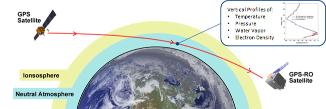
The satellites will use radio occultation to collect data that will supplement computer models on weather, producing more accurate and timely weather forecasts and assessments, PlanetiQ said. The satellites will measure how GPS, GLONASS, and BeiDou radio waves bend as they travel through the atmosphere, a technique that provides snapshots of temperature, pressure and water vapor, as well as insight into whether solar storms are active in the ionosphere, reports Discovery News.
Figure credit: PlanetiQ.
More than 30,000 occultation measurements can be collected each day.
PlanetiQ is one of five companies in the United States looking to commercialize weather forecasting. GeoOptics is working on a similar system and plans to launch its first satellite this year.
Explore further:
PlanetiQ President and CEO Anne Hale Miglarese discussed the project on The Weather Channel in August 2014.
Attila Komjathy, a NASA Jet Propulsion Laboratory principal investigator and adjunct professor in the University of New Brunswick’s Department of Geodesy and Geomatics Engineering, was named a Fellow of the Institute of Navigation in January for his work on remote sensing of the Earth’s ionosphere using signals from GNSS.