After much criticism in the mainstream and technology media about the commercial use of UAS (unmanned aerial systems), the Federal Aviation Administration (FAA) has been remarkably proactive in integrating the commercial use of UAS in the United States National Airspace System (NAS) the past two months. Just last summer, media like the Washington Post, fueled by a government audit, were reporting that the FAA will miss the September 2015 deadline, which is spelled out in the FAA Reauthorization and Reform Act of 2012, to integrate commercial UAS usage into the NAS.
By proactive, I mean the rate at which the FAA is issuing UAS exemptions for commercial use. Two weeks ago, the FAA issued eight more commercial UAS exemptions, bringing the total to 24 since June 2014, with the vast majority of those being issued in the last two months. The latest exemptions issued were for aerial mapping, motion picture and television production, and bridge inspection. You can view the entire list of exemptions and the intended applications here. All of the exemptions have more than 30 conditions and limitations the operator must follow, of which a FAA private pilot (or better) certificate and a FAA third-class medical certificate is required, as well as a second person, the Visual Observer (VO). That’s fine. There’s nothing new on that front since I last reported on this.
However, earlier this week, the FAA issued an NPRM (Notice of Proposed Rule Making) for commercial operations of “small” UAS, with surprisingly lightweight conditions compared to the exemptions granted thus far. Following are the key points of the NPRM:
Pilot must be 17 years of age or older.
Pass an FAA-approved aeronautical knowledge test and retest every two years.
Obtain an unmanned aircraft operator certificate with a small UAS rating.
Obtain an FAA Class II airman medical certificate.
Be vetted by the Transportation Security Agency (TSA).
Maintain visual line of sight without aids (except corrective lenses).
Not operate over any person who is not part of the mission.
Maximum UAS weight is 55 pounds.
Maximum airspeed of 100 mph.
Maximum altitude of 500 feet above ground level.
Minimum weather visibility of three miles.
Yield right-of-way to other manned and unmanned aircraft.
Contact air traffic control or airport operator when flying within five miles of an airport.
These conditions are certainly lighter than the conditions imposed on the exemptions issued thus far. However, instead of requiring an FAA private pilot certificate, the FAA proposes creating a new type of certificate named an “unmanned aircraft operator certificate.” Digging into the documentation, the new “small UAS pilot certificate” consists generally of the following:
At least 17 years of age, although the FAA seems open to reducing it to 16 years of age.
Read, write, speak English (with exceptions).
Pass an initial aeronautical knowledge test, which tests the applicant’s understanding of FAA regulations, airspace, flight restrictions, collision avoidance, weather/meteorology, weight/balance calculations, emergency response, aeronautical decision-making, airport operations, and drug/alcohol impairment.
Demonstrate flight proficiency and aeronautical experience. The FAA is asking for suggestions on these two.
For a summary description of the proposed Small UAS Limitations and Certifications, click here.
For a detailed description of the proposed requirements for the FAA small UAS pilot certificate, click here.
The FAA Class II Airman medical certificate requirement is somewhat surprising because it’s more stringent than the Class III medical certificate required in the exemptions issued thus far. Perhaps the FAA is rethinking this because of the line-0f-sight requirement that puts a premium on sharp vision for UAS pilots. Class II requires distance vision of 20/20 in each eye separately while Class III only requires distance vision of 20/40 in each eye separately. Click here to see the requirements for Class I, II and III medical certificates. To give you some idea, I had an FAA Class III medical exam completed last month. It took about an hour. Although I have an FAA private pilot certificate, one is not needed to obtain an FAA medical certificate.
FAA Class III Medical Certificate
Perhaps a bigger challenge than passing the FAA medical exam, which wasn’t difficult, was finding a certified FAA medical examiner near you. You can search for an examiner near you by clicking here.
So, it seems the FAA is making progress, and we should give them credit for that. But, we are still very early in the process, and as the mainstream and other media predict, the FAA will likely burn through the September 2015 deadline well into next year, albeit chipping away and issuing exemptions on a regular basis as they have been for the past two months. You can bet that exemption applications are piling up. To view the growing list of exemption applications, click here. In reading the FAA Reauthorization and Reform Act of 2012, it states “The FAA is required to initiate a Notice of Proposed Rulemaking (NPRM) for site integration of UAS within 18 months of the date of enactment of the integration plan.” Hmmm, 18 months from now = October 2016, and this NPRM is for small UAS only. Stay tuned….
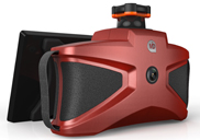
Pufferfish, a multitouch digital display technology company, displays its PufferSphere product at the 2015 Esri Federal GIS Conference, held Feb. 9-10 in Washington, D.C. PufferSphere is spherical, 360-degree display system made for multinational corporations, public and private institutions. It is innovating the understanding of trends, phenomena and correlations in global data.
LizardTech, a provider of software solutions for managing and distributing geospatial content, has released an updated version of its GeoViewer and GeoViewer Pro for Windows application.
The application allows users to view MrSID and JPEG 2000 imagery and includes broad file format support.
GeoViewer is available as a free application enabling users to display raster imagery, LiDAR point clouds and vector overlays. New features include the ability to connect to online base maps, combine local data with web map service (WMS) and JPIP sources, export imagery, save projects, and includes advanced display options such as dynamic range adjustment.
GeoViewer Pro is available for $50 and allows access to additional functionality, including support for printing, additional projection systems and advanced area measurement tools.
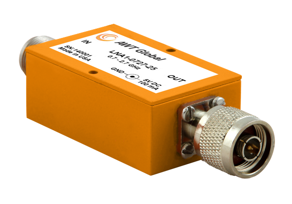
AWT Global has launched a new product line of low noise amplifiers: the LNA1 Series.
The new compact Low Noise Amplifiers (LNAs) are suited as RF measurement amplifiers and for signal boosting applications. LNA1 amplifiers cover telecommunications frequency bands from 700 to 2700 MHz. High gain of 25dB (+/-3) makes them perfect for applications like interference hunting.
“Due to its small form factor, LNA1 is well suited for mobile applications,” said Wolfgang Damm, president of AWT Global. ”LNA1 has been designed with power requirements of 5V/100mA, so it can be supplied by any USB port, standard at most portable instruments like spectrum analyzers.”
LNA1-0727-25 covers a frequency range of 700 to 2700 MHz. Impedance is 50 Ohms and VSWR ratio is 2.2:1. LNA1 features 25 dB (+/-3) of gain and 2.0 dB NF. Size is: 1.5” x 1.0“ x 2.5” ( 38 x 25 x 64 mm). Both, input and output comes standard with N-Type connectors, INP N(f) / OUT N(m). Other connector types are available on request. Power is supplied with a common 5.5 OD, 2.1 ID connector. AWT Global’s LNA1-0727-25 LNAs are available for sales immediately.
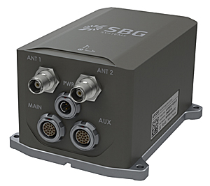
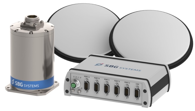
SBG Systems has released the Apogee Series, its most accurate inertial navigation systems based on robust and cost-effective MEMS technology. The INS/GNSS integrates the latest generation of MEMS sensors and a tri-frequency GNSS receiver. Apogee achieves 0.008° in roll and pitch in real-time and 0.005° in post-processing. With two antennas, it delivers a robust and accurate heading.
Four models compose the Apogee line.
The Apogee-A provides only orientation data.
The Apogee-N additionally embeds a GNSS receiver; it is a compact solution with one antenna for land and aerial applications.
The Apogee-D embeds a dual-antenna GNSS receiver for accurate heading under low dynamics conditions.
The Apogee-E delivers navigation data when connected to an external GNSS receiver or to the SplitBox with integrated GNSS.
Mobile Mapping. Apogee can be precisely synchronized with LiDAR equipment because of a UTC time-stamping accurate to 1 microsecond. This integrated INS/GNSS provides optimal position in multipath environment or during GNSS outages, thanks to a tight GNSS integration and the continuous fusion of inertial and odometer data. To get the required positioning accuracy, Apogee supports RTK and Precise Point Positioning services (Omnistar, Terrastar, and more).
Aerial Mapping and Remote Sensing. With very low noise gyroscopes, low latency, and high resistance to vibrations, the Apogee allows aerial surveys by plane or helicopter. It provides real-time orientation and position data with direct fusion of inertial and GNSS information. Compact, lightweight and low power, the Apogee is easy to install, and has an embedded web interface for configuration.
Post-processing. Orientation and position data can be recorded in the Apogee data logger. At the office, the user imports data in the post-processing software. This tool gives access to several RTK networks and reference station offline data (such as VRS and CORS.) Additionally, it enhances orientation and position accuracy by a complete “backward/forward” calculation.
“SBG Systems manufactures inertial systems from the concept to the production. The Apogee benefits from our high level of expertise in integrated design, IMU calibration, testing, and filtering,” said Alexis Guinamard, CTO of SBG Systems.
All models are available for order. Below is a promotional video with more information.
Editor’s Note: Tony Murfin is managing consultant for GNSS Aerospace LLC and editor of GPS World’s monthly Professional OEM newsletter. The views expressed are his own.
Another year has gone by, with another year of further improvements in navigation performance of micro-electro-mechnical systems (MEMS) inertial products. SBG Systems in France is now fielding a new generation of MEMS inertial products for much higher accuracy applications.
SBG Systems is based in Rueil-Malmaison, less than eight miles west of the center of Paris. Founded in 2007, SBG has developed a number of innovative MEMS inertial products over the last seven years, along with a respected reputation in the navigation industry, and by 2014 the company was recognized as the 26th fastest growing company in France.
The roots of the company began to form at the end of 2004, when a group of ECE School of Engineering students in Paris put a team together for a new UAV competition. The goal was to build a UAV of less than 1 kg, capable of flying autonomously indoors — at the time, a significant technical challenge. In 2004, miniature INS was not commercially available, so the team decided to build one, as well as other electronic parts such as the autopilot. The competition ran out of money, but the design was a success and led to a working UAV. The INS was by far the most advanced part of the project.
The students went back to their studies and took internships at UAV companies and ONERA (French aeronautics, space and defense research labs), but they still believed in the need for low-cost navigation solutions for the emerging civilian UAV market.
So, in 2007, three of the students — Raphaël Siryani, Thibault Bonnevie and Alexis Guinamard, S, B and G — formed SBG Systems with the goal of providing affordable, highly accurate MEMS inertial navigation systems for UAVs.
SBG quickly received its first Innovation Award from the French Research Ministry, and with this funding launched the IG-500 series of MEMS AHRS and INS in December 2008.
The company has since grown into a worldwide player with a strong product innovation focus. UAVs are still an important part of revenue, but the company has diversified into:
Aerospace and defense applications (UAVs, gimbaled cameras, antenna tracking, etc.)
Marine and offshore activities (ROV/AUVs, buoys, etc.)
Survey (hydrography, mobile mapping, aerial LiDAR, etc.)
SBG Systems has a small staff of mostly development and sales engineers — graduate students and experts. SBG has recruited navigation experts and some sales people from key players in the inertial business. Most (95%) have at least a master’s degree in engineering — R&D has 45% of the staff, and 40% are in sales, marketing and technical support. Production has been extremely automated and requires very few staff for in-house system assembly, calibration and final acceptance test. They do expect to double in size over the next two to three years.
The company is owned by the three founders, who still lead operations. SBG grew 1,304% over the last five years, and last year was ranked the 26th fastest growing company in France on the Deloitte Fast50. Today, SBG Systems has fielded more than 4,000 attitude and heading reference systems (AHRS) and INS (mostly INS), with almost a third of those delivered last year. The company forecasts growth for the next five years to be at this same phenomenal rate! SBG Systems currently offers a line of MEMS inertial sensors that include AHRS, inertial measurement units (IMU), and INS with embedded GPS (INS/GPS).
Ellipse-D dual-antenna mini INS/GNSS.
Not only have MEMS sensors improved in performance, but SBG has also developed advanced calibration capabilities that allow it to reach high-precision performance approaching high-end ring laser gyro accuracies in much smaller, less expensive packages. SBG owns an extensive set of temperature chambers combined with rotary tables and vibrating tables. Each SBG system gets to stay two to five days inside these calibration tools. But the “secret sauce” is in a state-of-the-art SBG developed calibration algorithm…
SBG buys MEMS gyros and accelerometers from MEMS manufacturers such as Colibrys, Analogue Devices and Silicon Sensing and builds complete inertial systems. The team embeds different GNSS receivers, depending on the product line and intended application — from miniature automotive-grade chipsets from u-blox to the very best from the key survey-grade players such as Septentrio, NovAtel and Trimble. Some customers may already have their own GNSS receiver, so SBG has developed and tuned their systems to work with any of these big manufacturers. The antenna employed depends on the receiver being used — from Tallysman Wireless and Antcom to Trimble, Septentrio or NovAtel — a very diversified range of antennas.
Ellipse-E.
SBG announced the Ellipse-D dual-antenna mini INS/GNSS earlier this month. The Ellipse-D is a miniature INS with an embedded dual-antenna survey-grade GNSS receiver for high-accuracy orientation and positioning.
Independent hydrographic testing in October 2014 of earlier model designs has already shown accuracy improvements, and the latest D version promises even better performance. The products tested were:
Ekinox-D
Ellipse-E, miniature inertial navigation system connected to a Hemisphere VS330 GNSS with two antennas.
Ekinox-D, inertial navigation system integrating a dual-frequency GNSS receiver with two antennas.
The test was a typical marine survey, with each leg about 550 meters long. Attitude performance was compared to a fiber-optic gyro compass reference system with much higher roll and pitch accuracy than the two SBG products under test.
Ellipse-E roll and pitch accuracy is better than the specs. The use of an RTK GNSS receiver additionally improves the sensor’s performance. The Ekinox-D also has good results — around 0.03° in both roll and pitch. SBG claims that low-noise gyroscopes and advanced algorithms are the basis for this performance.
The SBG list of 250 customers in 30 countries includes some impressive names, many outside Europe, and the company claims to have nearly 4,000 inertial sensors in the field. So this is not a prototype shop, but more a fully equipped production facility. SBG has opened an office in Chicago to address the North American market.
So, what are people doing with these devices? There are a number of applications in aerospace, land, marine and sub-sea.
In the aerospace industry, SBG sensors are used for UAV navigation and flight analysis — they could eventually be incorporated in certified avionics. They are also used for antenna tracking, camera stabilization and more demanding applications such as LiDAR orientation and data georeferencing.
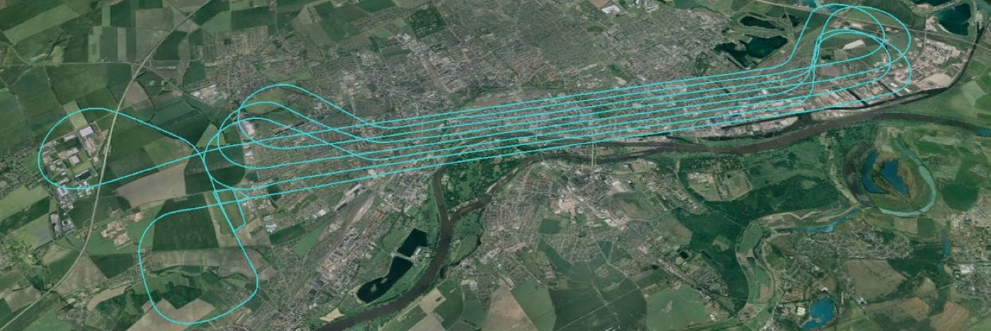
An Ekinox-N INS with embedded GNSS receiver was installed for the tests in a single-engine general aviation aircraft flying out of Magdeburg, Germany. A typical airborne survey-type flight was flown under mixed weather conditions with some turbulence, and roll, pitch, and altitude data was collected for real-time analysis and was also post-processed. A high-grade FOG-based AHRS was used as reference unit — with very high accuracy gyroscopes.
The flight pattern was typical of survey applications, with parallel straight lines of about 8.5 km. Altitude was 600 m and cruise speed was about 200 km/h.
Roll
Pitch
RMS Error Real Time (max)
0.043° (0.16)
0.043° (0.16)
RMS Error Post Processing (max)
0.017° (0.19)
0.025° (0.20)
Real-time accuracy remained below 0.05° RMS for roll and pitch. Post-processed output had a lower RMS error and a better stability over the whole flight. Only one GPS antenna was used in this test with Ekinox-N; nevertheless, heading reached an estimated accuracy of 0.06° when post-processed. The Ekinox-D model provides more accurate heading thanks to its integrated dual-antenna and GNSS receiver.
The Ekinox-N has been integrated on a UAV by Headwall in the U.S. for remote-sensing applications.
Headwall is a leading designer and manufacturer of high-performance hyperspectral imaging sensors for harsh environments. As a pioneer for remote-sensing applications, Headwall is the first to market a fully integrated remote-sensing solution combining hyperspectral and LiDAR sensors on a small UAV. This “total solution” approach has been welcomed by the remote-sensing market because it quickens time to deployment, decreases implementation costs, and enables operations in harsh environments.
The multi-rotor UAV carries Headwall’s lightweight Micro-Hyperspec VNIR hyperspectral sensor and a Velodyne LiDAR unit. The LiDAR collects a point cloud that reflects the field’s topographic relief, and the hyperspectral sensor delivers a picture showing spectral signatures of every object within the field of view. The SBG inertial navigation system has an embedded GPS and is used to provide positioning and orientation data. Weight is a key factor — Ekinox-N weighs only 500 grams, even though it integrates a survey-grade L1/L2 GNSS sensor to provide accurate positioning and precision roll, pitch, and heading data.
Mounted on the UAV, the Ekinox-N provides LiDAR and the hyperspectral camera with orientation and position during the whole flight. This and other data is recorded in real time at 200 Hz within the onboard computer. On the ground, the Headwall post-processing Hyperspec software fuses all sensor information. Ekinox-N data allows every scanned point and every pixel to be georeferenced and be tilt compensated to within a centimeter.
SLAM-based Indoor Mapping System by VIAmetris.
For miniature inertial sensors, smaller and lighter applications are possible at less cost. One of these applications includes the SLAM-based Indoor Mapping System by VIAmetris.
Simultaneous localization and mapping (SLAM) is becoming increasingly important to enable efficient indoor mapping. VIAmetris has created a different spin on indoor mapping with the “MID” portable SLAM-based scanner. This handheld system integrates a 2D LiDAR, a camera, an SBG Ellipse-A AHRS, and a tablet PC that shows the map being drawn while the user walks around inside the building. The AHRS also compensates for movement while orienting the generated maps to the north.
While the user walks, the 2D LiDAR scans in a horizontal plane by measuring 43,000 points per second across a 270° field of view. The SLAM technology progressively builds the map in the shape of lines made of points. At the office, the surveyor imports the data into the post-processing software and uses the lines of points to design the map. If there is any doubt about a specific shape — whether it is actually wall or furniture, for example — a photo of the location is available as MID automatically takes contextual pictures every meter, or whenever there is a change of direction, or manually.
The centimeter-level accurate map is then ready to be imported into most CAD software. As the system works without GPS, the generated map is not georeferenced or in a local coordinate reference system. To do so, the user links MID’s points cloud to a known point and all data is automatically referenced. MID is much easier to use than a laser distance meter, a tachometer, or a 3D scanner, and significantly reduces the time required for indoor mapping.
SBG is now working more often in the marine industry, equipping boat, cranes, or instrumented buoys. The company has even developed a specific solution for the hydrographic market. The SBG Ekinox Hydrography Solution integrates Ekinox-U which operates to a depth of 200 meters, and incorporates a SplitBox with a built-in tri-band RTK GNSS receiver and uses Terrastar, OmniSTAR, or Marinestar corrections.
The SBG Ekinox Hydrography Solution.
For subsea operations, positioning is required for ROVs and AUVs that navigate for minutes or sometimes for hours underwater. GPS fixes are only available when the vehicle comes close to the surface. But operators usually try to expend the time they are able to operate close to the seabed. To avoid typical INS drift, different aiding sources are used — the three main ones are acoustic positioning, Doppler velocity loggers (DVLs) and depth sensors.
Acoustic position is far more noisy and unstable than GPS.
DVL is a kind of 2D odometer, providing speed over the seabed.
The INS and the Kalman filter therefore play a key role to provide reference heading and reliable position data.
It’s a major concern when you have a massive ROV working on pipes under an offshore platform. Any mistake can cause severe damage and cost millions.
So SBG is moving along and taking on new, challenging applications with a range of MEMS inertial products that appear to be growing quite rapidly, with ever-improving performance. Once upon a time, we couldn’t stay anywhere within RTK-level performance during GPS outages because of the high drift-rate of MEMS inertial devices. Now, SBG has introduced its latest Ellipse-D dual-antenna mini INS/GNSS spec’ed at 0.1° real time for pitch and roll, with 2-cm RTK position.
The Apogee INS/GNSS.
And just today, SBG Systems has even bigger news with the release of the Apogee series, which is Apogee’s most accurate, robust and cost-effective MEMS technology inertial navigation system. The Apogee INS/GNSS integrates the very latest generation of MEMS sensors along with a triple-frequency GNSS receiver, achieving 0.008° in roll and pitch in real time, and 0.005° in post-processing. With two antennas, it also provides reliable and accurate heading.
Amazing what scientific skill, focused investment and time has done for MEMS inertial technology!
Apple is working on its own autonomous car, according to Reuters. An auto industry source told Reuters that the tech giant is gathering information and parts to make a prototype for the autonomous electric vehicle — the entire car, not just automotive software or components.
“They don’t appear to want a lot of help from carmakers,” said the unnamed source.
Apple is gathering advice on parts and production methods, focusing on electric and connected-car technologies, while studying the potential for automated driving, the source told Reuters.
“Fully automated driving is an evolution. Carmakers will slowly build the market for autonomous cars by first releasing connected and partially automated cars,” the source said. “Apple is interested in all the potential ways you can evolve the car; that includes autonomous driving.”
Meanwhile, Sony is also turning to autonomous vehicles, according to USA Today. The electronics giant is teaming up with Japanese robotics company ZMP to develop self-driving automobiles, reports the Financial Times. Sony invested 100 million yen (about $842,000) in ZMP.
Lockheed Martin and Esri have deployed commercial software to the Amazon Web Services Commercial Cloud Services (C2S) environment for the first time with an intelligence community customer, the National Geospatial-Intelligence Agency (NGA). The move enables government agencies to better share geospatial intelligence.
The deployment of the portal for Esri’s ArcGIS geographic information system (GIS) provides a single environment for analysts to securely organize and share data throughout the intelligence community and Department of Defense. It’s also the foundational step in consolidating multiple geospatial intelligence portals into the single NGA-provided portal, resulting in technology and license cost savings.
This is NGA’s second pioneering step in the cloud, after the agency moved its Map of the World application to the C2S environment late last year.
“Deploying Esri’s Portal for ArcGIS to a commercial cloud environment securely organizes existing data and facilitates collaboration across intelligence agencies,” said Jason O’Connor, vice president of Analysis and Mission Solutions for Lockheed Martin. “This cloud implementation also further shapes the government’s processes for architecting and implementing enterprise class services within a cloud environment.”
ArcGIS connects users to maps and geographic information. Users can create and view maps, compile geographic data, analyze mapped information and share geographic information in a range of applications.
“Working with Lockheed Martin and the NGA on this strategic implementation for national security is particularly meaningful,” said Jack Dangermond, Esri president. “It recognizes the importance of consolidating geospatial intelligence information into a single portal to facilitate rapid situational awareness and response by our intelligence community.”
Lockheed Martin and Esri have partnered for eight years on the Geospatial-Intelligence Visualization Services (GVS) program, which helped NGA and the Intelligence Community achieve this cloud migration milestone. The Total Application Services for Enterprise Requirements (TASER) GVS contract vehicle, which was originally awarded in 2012, conveys geospatial visualization context and analytic capabilities to warfighters, intelligence officers and policy-makers through classified and unclassified computer networks.
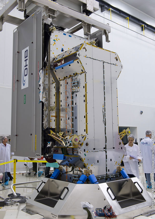
The Flight Model #3 (FM3) spacecraft is moved for positioning on the payload dispenser. (Photo credit: Arianspace)
The third and fourth Galileo Full Operational Capability (FOC) satellites are a confirmed “fit” for their Arianespace Soyuz launch March 27, having made initial contact with the mission’s dual-payload dispenser in French Guiana, according to Arianespace.
The fit check was completed over a two-day period inside the Spaceport’s S1A payload preparation building. The two satellites were installed separately, with the Flight Model #3 (FM3) spacecraft integrated on — and subsequently removed from — the dispenser on Feb. 9. Flight Model #4 (FM4) underwent the same process the following day.
The payload dispenser for Galileo was developed by RUAG Space Sweden for Arianespace, and carries one satellite on each side. It will deploy the spacecraft during the Soyuz launch by firing a pyrotechnic separation system to release them in opposite directions at the orbital insertion point.
Flight Model #4 (FM4) after its integration. (Photo credit: Arianspace)
Final integration on the dispenser is to be performed during upcoming processing at the spaceport, and will be followed by the completed unit’s installation on Soyuz.
The March 27 mission — designated Flight VS11 in Arianespace’s numbering system — will be the company’s fourth launch carrying spacecraft for the Galileo constellation. FM3 and FM4 were built by OHB System, with Surrey Satellite Technology Ltd. supplying their navigation payloads.
The Galileo network’s complete operational and ground infrastructure will be deployed during the Full Operational Capability phase, which is managed and funded by the European Commission. The European Space Agency has been delegated as the design and procurement agent on the commission’s behalf.
OxTS has released the xNAV550, its new compact and lightweight GNSS-aided inertial navigation system, along with an OEM board set version, the xOEM550.
xNAV550. The xNAV550 is the latest model in the xNAV family and the first to offer a position accuracy of 2 cm, yet remains a compact GNSS-aided inertial navigation system at 425 grams. Suitable for all applications where size and weight as well as performance matter, it is designed for use on UAVs and in other weight-constrained applications.
Featuring dual GNSS receivers and a custom-built inertial measurement unit, the xNAV550 constantly monitors position, orientation and velocity with high accuracy in real-time. Four gigabytes of on-board storage is available, automatically logging data for an added layer of protection. Data can be downloaded from the system and post-processed using OxTS’s advanced software, which is included as standard at no extra cost.
Integrating the xNAV550 with cameras, laser scanners or other sensor arrays is easy using the NMEA outputs, OxTS said, with 1-PPS and event input triggers for synchronization and time stamping. These features and the convenience of the one-box solution ensure that the xNAV550 make it quick and easy to acquire accurate data required for direct georeferencing, the company said.
xOEM550. The xOEM550 is designed for system integrators looking for a high-performance INS to build into a complete scanning and georeferencing system. Weighing 165 grams, it won’t add bulk to a system, and the free and distributable OxTS post-processing software enables system integrators to offer a turnkey solution at a competitive price, the company said.
OxTS will be exhibiting at ILMF 2015 in Denver, Colo., Feb. 23-25. Stop by Booth #30 to take a look at the xNAV and xOEM systems or contact [email protected] for more information.
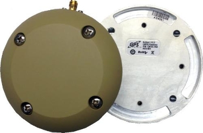
GPS Source has released a new GNSS antenna that is robust, lightweight, and suitable for harsh environments. It is designed for long-term, high-precision applications worldwide, the company said.
The antenna was engineered for the demanding aviation environment, in both commercial and military applications. Built to military standards (MIL-STD), it is impact resistant, tolerant of exposure to dust, chemicals and jet fuels, and has the ability to withstand shock and vibration.
Signal reception is unaffected by antenna placement. Designed to operate in the most extreme and demanding applications, it gives outstanding results, enabling maximum satellite reception, with ultra-low Dilution of Precision (DOP), GPS Source said.
“We are very excited about the new GNSS antenna,” said Robert Horton, CEO of GPS Source. “Our advanced technology provides superior performance in both GPS L1/L2 and GLONASS L1/L2. This is the best solution for technically demanding users.”
The antenna is available in multiple colors and with multiple connector options.
Fugro has launched the G4 service, designed to provide GNSS augmentation for offshore positioning applications. The new satellite correction service takes advantage of all four GNSS: GPS, GLONASS, BeiDou and Galileo.
By using all available GNSS satellites, Fugro’s G4 service is designed to improve availability and reliability of offshore positioning and thus enhance the safety and productivity of a wide range of survey and other activities offshore. G4 represents a significant advancement compared to augmentation systems which are based on GPS-only or GPS + GLONASS, the company said.
The BeiDou system operated by China currently provides coverage in the Asia-Pacific region. Fugro’s G4 service already utilises the first BeiDou satellites and is ready to start using the Galileo satellites as soon the EU announces Initial Operational Capability (IOC) status for this system. Galileo and future BeiDou satellites will be automatically included as they come online, steadily increasing availability and robustness of the integrated augmentation service.
The new G4 service will be particularly beneficial when the line-of-sight to certain satellites is obstructed by offshore structures – a key consideration during critical positioning operations. The G4 augmentation signals, transmitted via seven high–powered communication satellites to provide at least two independent broadcast channels anywhere in the world, will offer Fugro’s customers unrivalled coverage and availability.


 LizardTech