Blog

  • Global Asset Management, 11 Years On

    By Gary Naden, Geoforce Technology
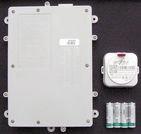
    A decade’s progress: on the left, the 2004 AXTracker. On the right, the 2014 GTO.
    A decade’s progress: on the left, the 2004 AXTracker. On the right, the 2014 GTO.

    Over a decade ago GPS World covered the introduction of the first battery-powered asset tracking device that operated over satellite networks, the AXTracker (“Going the Distance,” October 2003). More than ten years later, the technology has proven the market, and opened new markets. Battery powered tracking devices today are used for the expected, like enterprise asset tracking for trailers, containers, and field equipment, to the unexpected like tracking sea currents, ranging sheep, and weather balloons.

    The newest products are dramatically smaller, have much longer battery life, and pack accelerometers and Bluetooth for mobile phone connectivity and wireless sensor interface. Yet power management, cellular and satellite communications, and environmental ruggedness remain the technical challenge.

    Battery Technology. Advances have occurred in rechargeable technologies, largely driven by cellular telephones, military and automotive, but advances in primary batteries for industrial use are limited. Environmental operation is the problem. It remains extremely difficult to produce a primary cell that retains power for a decade while exposed to industrial temperature extremes. Global GPS tags for industrial use must operate in industrial temperature ranges of -40 C to + 85 C (-40 to + 185 F) while limiting self-discharge to enable operation over many years. Primary cells providing utility over the industrial temperature range with low self-discharge rates remain the same as available ten years ago.  LiMnO2 (lithium/manganese dioxide) and Li-SOCl2 (lithium-thionyl chloride) are still the leading chemistries. 

    Lessons learned from field deployments have produced quality improvements and better field longevity and yield. Not all AA batteries with the same paper specifications survive equally, so developers must be wary. Through power reductions in satellite communications and GPS technology discussed below, the asset tag of today can enjoy a volumetric and cost reduction for batteries while achieving the same service duration.

    GSatellite Network Technology

    Ten years ago, the available global commercial satellite machine-to-machine (data) networks included Iridium, Orbcomm, INMARSAT and Globalstar. Though several of the satellite network service providers are replacing retired satellites, the technology remains unchanged and developers are left with the same choices today as ten years ago. Each satellite network offers different strengths and weaknesses for specific M2M field applications with different power budgets required. The AXTracker of a decade ago utilized the Globasltar simplex capability specifically because of the power budget profile for data delivery. From a satellite network power perspective, the limitations of one-way (field to cloud) satellite solutions employed by that first tracker continue to out-weigh other satellite network offerings.

    In order to utilize the available satellite networks, the asset tag must integrate satellite communication circuitry. In a world of continuous technology improvements, the satellite transceiver evolution has been slow. Over the past decade most of the major satellite network providers have next-generation transceivers. However, the new technology has only marginally improved the power issues for battery-powered industrial GPS tags. For example, Iridium’s first OEM transceiver, the 9601, required peak power of 7.5W, with average power of 1.8W. Their latest transceiver, the 9603, is much smaller physically but still requires the same 7.5W peak, though average power is now 1W. Average power for an Iridium data packet delivery is the measure of the power used over message transmit and receive as well as idle times while accessing the satellite network. This average power for Iridium is the parameter used for calculating message delivery per a given battery capacity but peak power must also be supplied in any design that seeks to use the data service. Orbcomm and INMARSAT technology have similar power budgets due to their communications handshake requirements to access the network. For these systems, it remains difficult to source this power capacity and peak current requirements at -40C environmental temperature using batteries only.
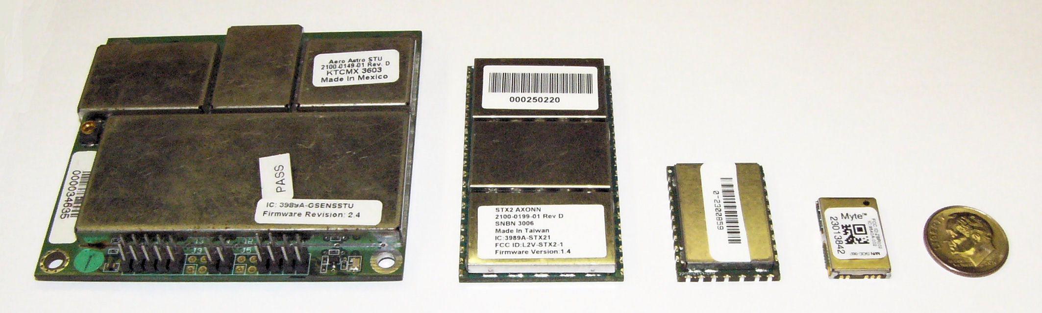
    (From left) STX1, STX2. STX3, MYTE.
    (From left) STX1, STX2. STX3, MYTE.

    Similar power improvements are available in the Globalstar simplex system. The Globalstar system is different than the other commercial M2M satellite networks in that data is merely transmitted one-way from the GPS tag to the network, thus removing the power needs for handshaking with the network to deliver data. The STX1 radio transmitter of eleven years ago required a whopping 6W during transmit, but thankfully was soon replaced with the STX2 radio transmitter. The STX2 is still the primary simplex transmitter in use today and requires 1.65W during the one-way short-packet bursts. The much lower and short duration requirements for power were, and are, the deciding factor for network selection for the original battery operated GPS tag. Today, the Geoforce MYTE radio transmitter embedded in the GT1 and GT0 devices requires 1.1W peak, an 82% reduction from the short-lived STX1 and a 33% reduction from the STX2. For simplex service, the peak power is used to calculate message delivery per available battery capacity since there are no network access or receive power requirements. Ten years of simplex transmitter evolution and size reduction enable fundamentally smaller asset tags while providing a 30% to 40% reduction in power required for satellite data delivery.

    GPS Technology. Improvements here have made the greatest power budget impact for tag developers, greatly reducing the total power and current required to ascertain a location. GPS chipsets of ten years ago would kill today’s smartphones in hours. The newest GPS cores operate at much lower voltages and operating currents. The GPS engine of the first AXTracker operated at 3.3V and required 70 mA operating current for an average cold-fix time of 45 seconds (10.4 Wsec of battery power). Geoforce’s GT1 and GT0 embed the Origin Spider GPS module that incorporates the SiRFstarIV GPS chipset. This GPS engine operates at 1.8V with 37 mA operating current and an average cold-fix time of 35 seconds (2.3 Wsec). Even for challenging GPS field deployments, this represents a conservative 75 percent power reduction for location determination.

    The power budget rule of thumb ten years ago was 20 percent went into idle sleep current, with the remaining 80 percent split roughly equally between satellite communications and GPS location determination. Improvements in satellite transmitter and GPS power technology have shifted the power budget ratio to 40 percent satellite communications and roughly equal power between idle sleep current and GPS location determination, for a net overall power reduction of roughly 33 percent.  This means that the tag of today can last 50 percent longer than the tracker a decade ago with the same battery capacity. Alternatively, today’s tracker can have 33 to 50 percent fewer batteries to achieve the same service life depending on operational configuration.
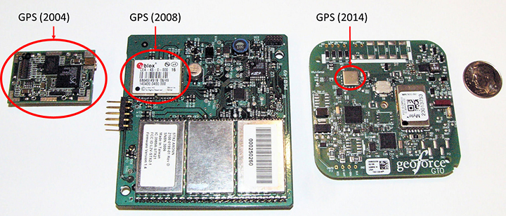
    GPS chipset evolution: from 2004 (left) to 2008 (center) to 2014 (right).
    GPS chipset evolution: from 2004 (left) to 2008 (center) to 2014 (right).

    What about Cellular? Ten years ago cellular M2M systems were as much in their infancy as satellite systems. The advance of cellular telemetry tracking systems has exploded far faster than satellite systems for powered fleet-type assets, yet there are far fewer battery-powered cellular systems than satellite today. Two primary contributing technology factors impede the introduction of battery-powered cellular systems: network availability and network power requirements. Cellular tracking services have good availability as long as the asset operating area greatly overlaps consumer cellphone service.  International and industrial applications have lower cellular regional overlap. As a result, battery powered cellular asset tracking devices remains a niche market. 

    Even if network coverage is acceptable, power budget asserts real technical problems for the developer. Cellular transceivers have similar power requirements as two-way satellite network, with high peak currents and relatively long network access dwell times. A multi-year, industrial temperature GPS asset tag operating over cellular is similar to a two-way satellite, requiring large capacity primary batteries, or rechargeable configurations that require frequent access to line power. For this reason, these battery-powered cellular asset tag technologies are seeing slower market insertion, leaving unpowered, industrial and international asset management applications to simplex satellite solutions.

    Environmental Packaging

    The largest product evolution observed in battery-powered asset tag technology is industrial packaging. Electronic and battery technology has remained fundamentally unchanged, however the packaging of these devices has changed significantly. Over the past ten years, the GPS asset tag has transitioned through many design and package iterations, all seeking to improve the reliability and service life of the industrial tag. Conflicting use-case requirements have contributed to field failures. Customers often demand features similar to commercial electronics systems such as rechargeable or replaceable batteries, or connectivity of remote sensors. While these features are highly desirable, they also lead to field failures in rugged, industrial environments. Chief among environmental failures is water intrusion.

    Customer expectations for wired sensor connectivity or battery replacement require connectors for wiring or panels to access the battery compartment with gaskets to prevent water intrusion. The stressors of industrial, multi-year fielded devices are unlike consumer electronics systems. Industrial tags are subjected to directed pressure washing, often at forces sufficient to cut plastic. And unlike commercial electronic systems, the industrial tags see the full temperature range of automotive-grade electronics while still providing compartments for battery replacement (something that most automotive electronics products do not require). Beyond liquid water intrusion, many products succumb to water vapor intrusion that subsequently condenses inside the device due to large temperature swings. Gaskets designed to prevent water are less able to prevent passage of small amounts of atmospheric vapor due to a vacuum created on temperature drop. The effect is easy to visualize if we apply the ideal gas law, PV = nRT where P is pressure, V is volume and T is temperature (n and R are constants). For a given volume inside the tag, the pressure changes proportionally with temperature, thus a tag that experiences a drop in temperature will also experience a drop in relative pressure and will pull in minute amounts of water vapor, which over time will condense and cause product failure.

    Several obvious solutions exist, starting with removal of internal air volume through encapsulation (potting).  Encapsulation seeks to take V to zero, thus making the device impervious to vapor intrusion caused by temperature swings.   Additionally gaskets can be removed at the tradeoff of inaccessible batteries.

    Putting It All Together

    The Geoforce GT0 leverages over a decade of lessons learned. It incorporates the smallest, lowest power simplex transmitter, salvaging 33% of power required for satellite communications. It also uses the Origin Spider GPS module, which includes the latest SiRFstarIV GPS chipsets, harvesting 50% of the power for location fixes. The GT0 also incorporates the latest circular polarized antenna technology from Tallysman, with unparalleled performance compared to previously available commercial patch antennas.

    The combined antenna design and power savings enable the GT0 to require only half of the batteries with an 85% reduction of device volume to achieve the same or better field service life compared with the tracker of ten years ago. The lower volume alone reduces the risk for water intrusion, but the risk is further reduced by the use of encapsulation and non-replaceable batteries. The GT0 is therefore fully sealed, disposable and encapsulated. This packaging concept makes the GT0 extremely rugged and impervious to directed water or water vapor intrusion. Thus, the GT0 is truly in a class of its own. The technology advancements and lessons learned over the past decade have enabled mechanical footprint and volumetric reduction of the global, battery-powered GPS asset tag.

    The GT0 combines the smallest, lowest power satellite and GPS engines with innovative packaging to create the smallest, industrial-grade global satellite asset management tag available anywhere, setting the bar for size, value and performance.

    Asset managers today need more than dots on a map. They need asset utilization metrics that provide actionable information for improving operations. Knowing where an asset is and where it is moving is sometimes enough, and for these applications GPS enabled, battery-powered tags provide supreme value. New tags provide the value of track and trace, but also can relay data from nearby sensors using short-range Bluetooth wireless interfaces.  This capability will evolve the utility of yesterday’s global tag, closing the gap from location only toward satellite-based telematics, but that is a story for another day.


    Gary Naden serves as Chief Technology Officer at Geoforce, manufacturer of satellite telemetry asset tags for oilfield and hazardous environment use.
  • The System: ESA’s Second FOC Moves Up

    The System: ESA’s Second FOC Moves Up

    The fifth Galileo satellite is now pointing toward Earth.
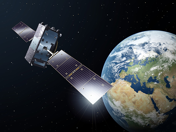
    Milena, or Galileo-FOC FM2, moves above the dangerous Van Allen Belt to rejoin Doresa, Galileo-FOC FM1, in a partially usable orbit. Photo: Galileo

    By Tim Reynolds, GPS World European correspondent

    Director General Jean-Jacques Dordain of the European Space Agency (ESA) announced Jan. 16 that the second errant full-operational capability (FOC) satellite, launched in August, had started its orbital change maneuver the previous day. He anticipated that the orbital change would be completed and the final orbit — “albeit somewhat lower in height than the one into which it was supposed to go” — achieved in “a few weeks.” He confirmed that both in-orbit FOCs work well, are fully operational, and provide excellent on-spec positioning data.

    Two more FOC satellites are ready for launch, and a third has undergone thermal vacuum testing. Dordain said four will be available to launch soon, and he anticipated up to six FOCs being ready for launch in 2015 [word came at press time that all 2015 launches would be aboard the previously problematic Soyuz vehicle, and not on heretofore reliable Ariane]. The previous plan had called for four in 2015, but the total now includes two that were held back from a December 2014 launch. The actual schedule and launch vehicles are still under discussion, according to Dordain; the European Commission (EC) will make a decision at the end of January on this. He refused to comment on what ESA would recommend to EC on this front.

    Read Tim Reynolds’ Brussels-based reporting the in EAGER quarterly enewsletter; free at gpsworld.com/subscribe.

    OCX, GPS III Pass Key Test

    Raytheon Company and Lockheed Martin successfully completed the fourth of five planned launch and early orbit exercises to demonstrate new automation capabilities, information assurance, and launch readiness of the next-generation GPS III Operational Control System (OCX).

    The completion is a key milestone towards end-to-end capability to automatically transfer data between Raytheon’s OCX and Lockheed’s GPS III satellite. One more readiness exercise, five launch rehearsals, and a mission dress rehearsal are planned before launch of the first GPS III with OCX.

    The exercise demonstrated mission planning and scheduling capabilities with the simulated Air Force Satellite Control Network (AFSCN) for the first time, including a replan scenario that would occur in the event of a launch slip.

    The system also automatically generated antenna pointing angles for the simulated AFSCN — until now, manually generated. Exercise 4 introduced maneuver planning and reconstruction capabilities, as well as advanced planning and scheduling with AFSCN assets. Automation of these capabilities will allow GPS operators to optimize system performance rather than focus on routine operations.

    Brigadier General Cooley

    Colonel William Cooley, director of the GPS Directorate, has been nominated to the rank of brigadier general, United States Air Force. He wrote a December GPS World article on “What It Takes to Make a Gold Standard.”

  • Out in Front: Yes, We Have No Bananas

    What if the U.S. government stepped in and confiscated all your bananas? Grown foreignly, they lack proper accreditation to enter this country. That they have done so for years is no excuse. They are illegal. Those who consume said bananas engage in unlawful activity. Those who facilitate such consumption — you, in this case, whom we imagine to be a vendor of shakes, smoothies, and fruit juices — are aiding and abetting, colluding, conspiring, something like that.

    Bananas are no more above the law than anyone or anything else. They must fill out the proper forms.

    And the same goes for all you other tropical fruits out there! If you spring from foreign soil, and if you pack exotic flavors unfamiliar and most important, unapproved, in the land of apple pie.

    Today’s bananas are GLONASS signals, and the other fruits, those from other international GNSS. The PNT user community within the United States who use such multi-GNSS signals, other than GPS, technically do so illegally.

    These revelations come via the U.S. Federal Communications Commission (FCC) and the National Telecommunications and Information Administration (NTIA). Some in the industry-user community have been aware of this technicality, and have been patiently awaiting a blanket waiver that would take care of the matter. The waiver will appear, we have been told, any day now.

    We are waiting. Sitting, and waiting. Like good citizens of the republic.

    A spokesperson for the the GPS Innovation Alliance (formerly the U.S. GPS Industry Council) stated that it, too, is very patiently waiting. “The process for securing a waiver of FCC regulations requiring authorization to receive international RNSS satellite signals was identified in an FCC Public Notice released in 2011. This process is initiated by National RNSS System providers, which have the satellite information needed to secure a waiver. GPSIA members remain fully committed to producing  multi-GNSS signal user equipment consistent with U.S. policy, and to working with the FCC and NTIA in considering these requests.”

    To review the FCC/NTIA briefing: “Radio Regulator Spectrum Management Perspectives & Priorities: Emerging Trends in Spectrum-Efficient Technologies,” see www.gps.gov/governance/advisory/meetings/2014-12/.

    The NTIA and FCC perform these functions on our behalf:

    • Allocate spectrum, while promoting new technologies and services.
    • Develop service rules: share spectrum while minimizing interference risks.
    • Assign frequencies, for interference protection among authorized stations.
    • Enforce rules.

    Some of the frequencies used by GLONASS, Galileo, and other foreign PNT systems are not authorized for use in the United States, as they may interfere with other signals. Since they are not authorized or certified, they have no guarantee of protection in the United States. The NTIA and FCC protect users from unauthorized foreign PNT signals.

    The European Union and Galileo have formally asked for a waiver and are completing the necessary paperwork.

    Let’s hope that common sense prevails soon over international gamesmanship, a waiver is granted, and this all goes away. Such a waiver reportedly sits on the desk of the appropriate person. Sits and has sat.

    To our mantra of location, location, location, we must add a corollary.

    Education, education, education.

  • The Business — February 2015

    The Business and Hey, AU sections from the February 2015 issue. Download the PDF.

    The Business includes:

    • GeoOptics Study Supports GNSS-RO
    • SkyTraq Offers Module for Wearables
    • Ford Autonomous Vehicle On the Way
    • U.S. Army Explores eLoran PNT
    • Briefs

    Hey, AU: Autonomous Unmanned includes:

    • FAA Grants UAS Exemptions
    • OriginGPS Module Powers Tiny Drone


  • OxTS Offers Core Module for Inertial, GNSS

    OxTS Offers Core Module for Inertial, GNSS

    Oxford-Oxts-Core_hand Photo: Oxford Technical Solutions
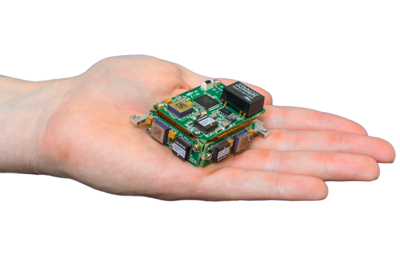
    Oxford Technical Solutions’ xOEMcore. Photo: Oxford Technical Solutions

    The xOEMcore, now being offered by Oxford Technical Solutions (OxTS), is an inertial navigation system that can also serve as a framework for other positioning systems.

    The xOEMcore is a combined six-axis inertial measurement unit and navigation system with sensor fusion in one compact OEM module. In its base form, the xOEMcore measures and outputs raw accelerations and angular rates with small, high-grade MEMS gyros and accelerometers. With a simple upgrade, the xOEMcore is turned into a full inertial navigation system, able to take aiding data from external sources such as GNSS and blend it in the on-board Kalman filter. It is desgined for integration inside any solution that requires robust, high-performance position and orientation.

    xOEMcore provides continuity from one point to the next, so detecting unexpected measurements from other devices is easy, the company said. It has deterministic error growth for accuracy, a high update rate and low delay, enabling easier control of vehicles and robots.

    As a framework, the xOEMcore can be merged other technologies, such as GNSS and vision positioning. The xOEMcore solves conflicts between the two systems, removing timing mismatches, delays, jumps and inconsistencies.

    The xOEMcore is small, light and low power. The inertial sensors have low drift rates — less than 5-meters drift after 60 seconds can be achieved in real-time with only odometer aiding. Heading, roll and pitch can be accurate to 0.05 degrees, exceeding magnetic heading and vertical reference system performance.

    For a demonstration or for more informtion, contact [email protected]..


  • Blue Marble Releases 2015 Dates for Training Sessions

    Blue Marble Geographics is hosting a series of training sessions, starting with a session in March in Washington, D.C.

    The sessions are aimed at GIS professionals, or those just starting a career that requires the use of GIS software training. All attendees who successfully complete the required courses will be recognized as a certified Global Mapper or Geographic Calculator user. For detailed information on the class content, see the register link below.

    Washington, D.C., Area

    Topics: Global Mapper, Applied Geodesy & the Geographic Calculator
    Registration Deadline: March 2, 2015
    Dates: March 16-20, 2015
    Time: 8 a.m. to 5 p.m.
    Location: Westfields Marriott Washington Dulles
    14750 Conference Center Drive, Chantilly, VA 20151

    Sign up Options: Sign up for one class or all four.

    Cost

    Length

    Title

    Date

    FREE

    8 hrs

    GM1: Introduction to Global Mapper

    March 16, 2015*

    $996 pp

    24 hrs

    All 3 Days of Global Mapper Certification Training

    March 17-19, 2015*

    FREE

    8 hrs

    GM1: Introduction to Global Mapper

    March 17, 2015*

    $498 pp

    8 hrs

    GM2: Advanced Data Processing

    March 18, 2015*

    $498 pp

    8 hrs

    GM3: LiDAR, 3D Modeling, & Terrain Analysis

    March 19, 2015*

    $498 pp

    8 hrs

    Applied Geodesy & Geographic Calculator Training

    March 20, 2015*

    2015 Public Training Locations

    Area

    Date(s)

    Registration Deadline

    Washington, DC

    March 16-20, 2015*

    March 2, 2015

    Ottawa, ON

    April 27-May 1, 2015*

    April 13, 2015

    San Diego, CA

    July 20-24, 2015*

    July 6, 2015

    Orlando, FL

    November 2-6, 2015*

    October 19, 2015

    * Dates are subject to change.

    For more information, visit Blue Marble’s Public Training page.

  • Pirker Drone Case Reaches Settlement

    Aerial photographer Raphael Pirker has settled the civil penalty proceeding brought by the U.S. Federal Aviation Administration in 2013 concerning his flight of a styrofoam Zephyr II model aircraft (or “drone”) at the University of Virginia at Charlottesville in October 2011.

    The $1,100 settlement  “does not constitute an admission of any of the allegations in the case or an admission of any regulatory violation,” Pinker’s attorney Brendan Schulman said in a statement.

    On December 1, the National Transportation Safety Board ruled in favor of the FAA, when the FAA appealed a decision by an NTSB Administrative Law Judge in Huerta v. Pirker after the judge dismissed the FAA’s order requiring Pirker to pay a civil penalty of $10,000 for operating an unmanned aircraft in a careless or reckless manner at the University of Virginia in October 2011.

    Pinker was said to have been hired to supply aerial photographs and video of the university campus and medical center. He had argued that his aircraft, which was described as an UAS, was in fact a model aircraft.

    Schulman wrote: “We are pleased that the case ignited an important international conversation about the civilian use of drones, the appropriate level of governmental regulation concerning this new technology, and even spurred the regulators to open new paths to the approval of certain commercial drone operations.

    “The decision to settle the case was not an easy one, but the length of time that would be needed to pursue further proceedings and appeals, and the FAA’s new reliance on a statute that post-dates Raphael’s flight, have diminished the utility of the case to assist the commercial drone industry in its regulatory struggle.”

    Read the full settlement agreement below.

    pirker-faa-settlement.pdf

  • IS-GNSS 2015 Issues Call for Papers for Kyoto Conference

    The organizers of the International Symposium on GNSS (IS-GNSS 2015) are seeking paper submissions. The symposium will be held Nov. 16-19 in Kyoto, Japan.

    The International Symposium on GNSS is designed to bring together experts engaged in PNT and GNSS technologies — including industry professionals, practitioners, academics and researchers — to disseminate their latest research results and allow cross-disciplinary exchange of knowledge to further advance the fields.

    The program will include keynote addresses, oral presentations, interactive poster sessions, panel sessions, open interactive forums and an informative trade exhibition.

    The Asia and Pacific Rim meeting of the CGIC (Civil GPS Service Interface Committee) will be co-located with ISGNSS 2015 to help improve understanding of world trends in developing and deploying GNSS.

    Kyoto is the ancient capital of Japan and a top tourist destination, organizers said, with the conference scheduled during the best sightseeing season.

    Registration will open April 1, along with a hotel booking page. The logistic information will be announced later.

    A student scholarship is being offered to the student with the most promising paper. “If you have students, please encourage them to apply,” said Akio Yasuda, president of Institute of Positioning, Navigation and Timing of Japan.

    For more information on the conference, including sponsorships and exhibits, email [email protected].

  • U of Michigan Wins ION’s Fifth Autonomous Snowplow Competition

    U of Michigan Wins ION’s Fifth Autonomous Snowplow Competition

    The University of Michigan's snowplow. (Photo: Rory Thomas).
    The University of Michigan’s snowplow earned the team $7,000 and a Golden Snow Globe Award. (Photo: Rory Thomas).

    A team from the University of Michigan took home the fifth Institute of Navigation (ION) Satellite Division’s Autonomous Snowplow Competition. The competition was held Jan. 22-25 at Rice Park in downtown Saint Paul, Minn., in conjunction with the 129th Saint Paul Winter Carnival.

    Sponsored by The ION Satellite Division and held in cooperation with the ION North Star Section, the ION Annual Autonomous Snowplow Competition is a international event open to college and university students, as well as the general public, that challenges teams to design, build, and operate a fully autonomous snowplow using state of the art navigation and control technologies to rapidly, accurately and safely clear a designated path of snow.

    Eight teams participated during the four day competition, each using state of the art navigation systems to plow two different snowfields.

    Teams included students, partners from private industry and faculty advisors from Case Western Reserve University; Dunwoody College of Technology; North Dakota State University, University of Calgary, University of Michigan, Dearborn, and The University of Minnesota – Twin Cities.

    The winning snowplow by the University of Michigan team. (Photo: Kristen Sheikh)
    The winning snowplow by the University of Michigan team. (Photo: Kristen Sheikh)

    Teams were judged based upon their cumulative scores earned throughout the competition phases: 75% of the total score was based upon the plowing competition; and 25% of the total score was based upon the presentations and pre-event report.

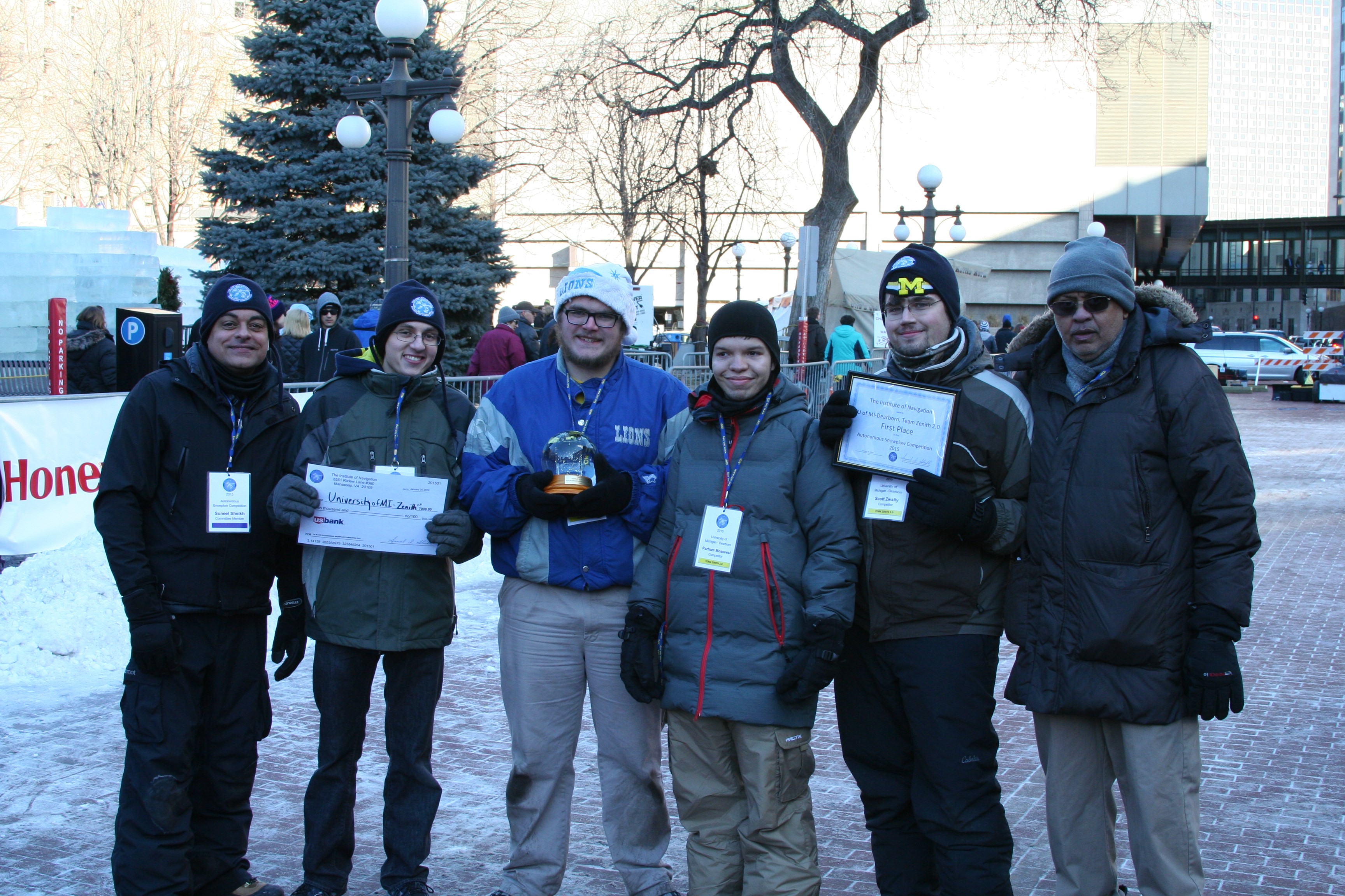
    • First place was awarded to the University of Michigan, Dearborn’s team “Zenith 2.0.” The first place prize included $7,000 and a Golden Snow Globe Award.
    • Second place was awarded to the University of Michigan, Dearborn’s team “Yeti 5.0.” The second place prize included $4,000 and a Silver Snow Globe Award.
    • Third place was awarded to the Dunwoody College of Technology’s team “Snow Devils 01012.” The third place prize included $2,000 and a Bronze Snow Globe Trophy.

    In addition, the first place team, University of Michigan, Dearborn, has been invited to display the winning snowplow during ION GNSS+ 2015 conference Sept. 14-18 in Tampa, Florida.

    Sponsors of the Fifth Annual ION Autonomous Snowplow Competition included Lockheed Martin Corporation, ASTER Labs, Inc., Honeywell, Inc., Alliant Techsystems Inc. (ATK), UTC Aerospace, US Bank, Space Exploration Technologies Corp. (SPACEX), The Toro Company, John Deere and Company, Proto Labs, Inc., Nuts and Volts Magazine, Servo Magazine, and Achievement Rewards for College Scientists Foundation (ARCS).

    The competition received national media attention in addition to considerable local coverage helping to advance the goal of driving innovation for the future of autonomous robots.

    The Sixth Annual ION Autonomous Snowplow Competition will be held in January 2016 at the Saint Paul Winter Carnival, St. Paul, Minnesota. For more information, visit www.autosnowplow.com.

    inning team from the University of Michigan, Dearborn’s “Zenith 2.0.” From left: Suneel Sheikh, Jason Spurlock, Benjamin Pollatz, Paraham Moassesi, Scott Zwally, Narasimhamurthi (Nattu) Natarajan (team advisor).
    inning team from the University of Michigan, Dearborn’s “Zenith 2.0.” From left:
    Suneel Sheikh, Jason Spurlock, Benjamin Pollatz, Paraham Moassesi, Scott Zwally, Narasimhamurthi (Nattu) Natarajan (team advisor).
  • 2, 4, 6, 8 — Who Do We Appreciate?

    Galileo, that’s who! For dogged determination and persistent pushing-forwardness in the face of adversity, obstacles, and the occasional technical difficulty. That there may be occasional confusion, as well, or mixed messages as to just what the future may bring, is certainly understandable. In fact, it is to be expected, given the circumstances.

    Let’s review the math.

    Two

    Two for the two launch vehicles that Galileo may use in the near future, Soyuz Fregat and Ariane 5. The Soyuz rocket can lift two satellites of the Galileo punching weight. The Ariane 5 rocket can carry four into space.

    Soyuz Fregat has a losing record so far with Galileo, being responsible for the August 2014 loosening of the first two full-operational capability (FOC) satellites into the dangerous Van Allen Belt. The first of these satellites has been successfully repositioned by the European Space Agency (ESA) into a mostly-but-not-totally useable orbit, and the second is currently en route to a similar spot.

    We do not wish to say we told you so, but we will. Back on March 26, 2014, we wrote on these virtual pages, “ESA’s year-end plan calls for two more dual-satellite launches in October and December on Russian Soyuz rockets — new partners to the Galileo dance, bringing perhaps new technical connectivity issues.”

    “Rockets are tricky,” said Tesla/SpaceX CEO Elon Musk, after his Falcon 9 Reusable rocket exploded over Texas at roughly the same time that Soyuz Fregat mis-delivered two Galileo satellites into wrong orbits.

    Musk meant tricky in actual operation, but we may also add, tricky in scheduling, in getting a cargo aboard a spacebound vehicle. Arianespace’s calendar is particularly filled with telecomm satellites impatient to be put aloft, with Ariane 5 being the preferred launcher of many. Soyuz availability, understandably, is somewhat more open.

    Four

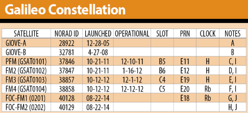
    Four for the total of four Galileo satellites now orbiting and broadcasting useable signals at all times for all users. These four come from the in-orbit validation (IOV) generation.

    Galileo-chart-Jan2015

    The two added FOC satellites, no longer in a bad orbit, now in a sort-of-pretty-good orbit, should be useable at some times, for some purposes, by some people. Peter Steigenberger and André Hauschild, researchers at the German Aerospace Center (DLR) / German Space Operations Center, wrote in this magazine in January that:

    “Despite the orbit injection error, the new Galileo FOC satellite has now been successfully activated and added to the Galileo constellation. Unfortunately, the current orbit is incompatible with the standard Galileo almanac format, which may cause restrictions for some commercial receiver types.

    “Nevertheless, the satellite can already be tracked by a wide range of geodetic receivers with existing firmware versions and it will, in fact, be possible to use the new satellite for diverse applications in surveying, precise positioning, and geodesy, as well as in general multi-GNSS studies. We now look forward to the activation of the second FOC satellite, which can be expected in early 2015 and will, for the first time, offer multi-frequency signals from a total of five Galileo satellites.”

    If you have four fully useable satellites and two partially useable satellites, what do you have? Does six = five functionally in this case? Or perhaps 5.5?

    Six

    Six for the oncoming new Galileo FOC satellites to be launched in 2015, according to some schedules and some official announcements.

    On a year-opening preview of operations given on Jan. 19, Thomas Reiter, Head of the European Space Operations Centre (ESOC) in Darmstadt, Germany, outlined the launch schedule for Galileo in 2015. Six new FOC satellites in total:

    • Galileo L4 with two on March 26
    • Galileo L5 with two in September
    • Galileo L6 with two in December.


    Now, six satellites divided by three launch dates gives two satellites per launch. Seeming to indicate a Soyuz rocket for all three dates. Reiter did not mention any rocket by name, but this would be the inference.

    That’s putting a brave face on the situation. Back in May, Russia suffered its fifth rocket launch crash in the past four years, raising serious concerns about the reliability of Russian rockets and launch procedures. Subsequently, the August Galileo launch that went so wrong was controlled by Arianespace, but it did use the Russian equipment.

    It strains credulity that an omission or oversight in the system thermal analysis  during stage design of a million-dollar rocket, designed to carry million-plus-dollar satellites in a 21st-century endeavor, could permit the creation of a thermal bridge between two feed lines, causing one of them to freeze during a crucial phase of space operations — but that is what apparently happened at some point at NPO Lavochkin in Russia, and that is what ultimately caused Galileo such misfortune. All parties concerned swear that this problem has been corrected in every other Soyuz Fregat, but who knows what other anomalies lie undiscovered therein?

    So putting all your 2015 money aboard Soyuzes is really rolling the marbles. Even if, as Elżbieta Bienkowska, Member of the EC in charge of Internal Market, Industry, Entrepreneurship and SMEs stated at this week’s 7th European Space Conference: EU Space Policy Confronted With the Rising Demand for Services and Applications, “We agreed to contract insurance for the next launches.”

    Eight

    Eight for the oncoming new Galileo FOC satellites to be launched in 2015, according to other schedules and other official announcements.

    “2015 will be a crucial year for the European space industry. We have big plans,” said Maros Sefcoviv, vice-president of the EC in charge of Energy Union, earlier at the very same 7th European Space conference, EU Space Policy Confronted With the Rising Demand for Services and Applications.

    “On the biggest one, we are planning five launches, which will bring up to space 10 satellites: eight for our Galileo constellation, and two for Copernicus. This is something that will put these programs over, I would say, over the edge, in a way, to be able to offer early services from Galileo, and to develop the program of Copernicus. It would prove the resilience and competitiveness of the European space industry, and its ability to serve the businesses, and what I think is most important, to offer new kinds of services to the citizens.”

    “For our flagship programs like Galileo and EGNOS, our priority must be to deliver services as soon as possible. That is why the satellites have to be delivered and operations must be ready as soon as possible.”

    Now, if you have eight satellites to go up in three launches, that would mean one of them has to go with four aboard. Thus, an Ariane 5 Galileo launch this year after all? Or possibly four Soyuz launches, although one more launch date could just just as hard to come by as a launch vehicle.

    Hard to tell. Very hard to tell. Extremely hard to tell, from the outside.

    Those who do not study history are condemned to repeat it, goes the dictum. Those who do study GNSS history, in this case, are likely only to repeat past pronouncements without any perceptible advance in clarity.

    Way, way back in March 2013, an EC program manager told GPS World, “Then, in 2014 [after four FOC satellites were to rise in 2013, which did not happen] we will see three Soyuz launches of two satellites each. We do not have the precise launch dates yet, but they are likely to be in April, June, and September. In December 2014, we expect to have the first launch using the Ariane 5 launcher, which is capable of deploying four satellites in one go. This means that by the end of 2014 Galileo will have deployed 18 satellites in orbit.”

    Now, the target has moved several times since then, and the schedule has slid accordingly.

    “In 2015, there will be two Ariane 5 launches, one in the middle of the year, one at the end, each carrying four satellites.”

    Six or Eight?

    Either number this year, we would surely appreciate. To return to Ms. Bienkowska, she left a little fudge room in her presentation: “We aim to launch at least six satellites this year.”

    Well, at least we are all moving forward. Resolutely.

    ——————————–

    I am indebted to Tim Reynolds, GPS World’s Brussels-based European correspondent, and to Peter de Selding, Paris bureau chief of SpaceNews, for their assistance in gathering diverse intelligence on this topic. Tim Reynolds will have an up-to-date view of this and other Galileo developments when we publish the next issue of the EAGER* newsletter at the end of March. Subscribe for free.

    * The European GNSS and Earth Observation Report

  • FAA Warns Super Bowl Fans: Leave Drone at Home

    The Federal Aviation Administration (FAA) declared today that Super Bowl XLIX will be a “No Drone Zone.”

    “Many familiar sounds are associated with the Super Bowl: Cheering fans. Referee whistles. The spectacular halftime show. Booming fireworks,” the FAA wrote. “But one sound you shouldn’t hear is the whirring of an unmanned aircraft overhead. The Super Bowl is strictly a ‘No Drone Zone’.” The restriction applies to University of Phoenix Stadium in Glendale, Arizona, during the game.

    The FAA bars unauthorized aircraft — including drones — from flying over or near NFL regular- and post-season football games. The same restriction applies to NCAA college games in stadiums seating 30,000 or more fans, Major League Baseball games and many NASCAR events. Other unauthorized aircraft include airplanes, hang gliders, hot air balloons, and model rockets.

    The FAA Notice to Airmen makes it crystal clear that anyone violating the rules may be “intercepted, detained and interviewed” by law enforcement or security personnel. Besides possibly landing a violator in jail, flying an unmanned aircraft over a crowded stadium could result in an FAA civil penalty for “careless and reckless” operation of an aircraft.

    The agency also produced a YouTube video with the same message.

  • USAID Issues RFI to Expand Geospatial Technologies

    The United States Agency for International Development (USAID) is seeking services from companies to expand its existing geospatial technologies. USAID’s mission is to support developing nations, and its GeoCenter geospatial tools help map and manage its global projects.

    In a request for information issued on Jan. 20, USAID said: “The purpose of this RFI is to solicit input from organizations involved in managing, analyzing and visualizing data, particularly for the purposes of informing policy and decision-making in international development. In this RFI, we seek to gather information about the scope of a draft Statement of Work (SOW) and the community’s capabilities to fulfill these requests. In particular, we want to understand the available expertise, the feasibility, and challenges faced in responding to the services outlined in our draft SOW.”

    USAID’s Data and Analytics team is seeking to partner with external organizations to provide support for data management, analysis, and visualization, particularly in the following five areas:

    • Data analysis and visualization
    • Research to contextualize development efforts and challenges
    • Data infrastructure and information sharing
    • Futures analysis and scenario planning
    • Training and support to build agency and host-country capacity in data and analytics.

    Learn more on its Federal Business Opportunities page.