Blog

  • Visual Intelligence, Cardinal Systems Agree to Combine Image Collection, Data Processing

    Visual Intelligence and Cardinal Systems have entered a strategic agreement that the companies say will combine high-quality and affordable aerial image collection with the processing and delivery of intelligent data for large-scale and UAV imaging applications. The combination will enable unprecedented positional accuracy for oblique and 3D products, the companies said.

    The Visual Intelligence iOne Sensor System is reconfigurable, and supports various image types including nadir and oblique. The Cardinal Systems triangulation solution efficiently handles the aero-triangulation of oblique and nadir images together, correlating the orientation points in both sets of imagery simultaneously, achieving better than 2 pixel absolute accuracy.

    The two companies plan to release a large-scale production solution in early 2015.

    “Visual Intelligence is pleased to team with Cardinal Systems to integrate the Vr Mapping software suite with our iOne Sensor System solutions. Using Cardinal Systems’ powerful mapping tools with an iOne Sensor System will give image providers a highly-effective end-to-end workflow that will significantly enhance the collection, production, and use of oblique aerial images to generate 3D models in industries such as insurance, real estate, construction, urban planning, utilities, and public safety,” said Visual Intelligence President and CEO Armando Guevara.

    A provider of high-quality multipurpose digital sensor systems for airborne geo-imaging applications, Visual Intelligence’s technology innovations include sensor systems that are field-configurable to support a variety of applications, including large-area collection to oblique for 3D applications.

    “We are impressed with the quality imagery that is produced using the iOne Sensor System. Aerial image providers can benefit from the system’s versatility and performance and, together with Cardinal Systems’ Vr Mapping software, we provide an ideal turnkey solution for stereo and oblique airborne acquisition customers,” said Mike Kitaif, manager of Software Development for Cardinal Systems.

    The vertical and oblique imagery collected with the iOne Sensor System is extremely precise, which contributes to the high-quality image data produced by the Vr Mapping software suite, the companies said. In addition, integrating the software and hardware solutions bring new and efficient aerial imaging technologies that use the same base architecture and software processing suite.

    “Aerial image providers will now have a coordinated hardware and software bundle that will give them a cost-effective and modernized workflow that will produce highly-accurate images that are rich in data,” said Jane Smith, managing member of Cardinal Systems.

    Visual Intelligence and Cardinal Systems will be available to discuss benefits of their combined products at the MAPPS Winter Conference January 25-29, 2015 and the International LiDAR Mapping Forum February 23-25, 2015.

  • Chinese BeiDou/GPS Module Aims to Serve Civilians

    A new module produced by a Chinese company combines GPS and BeiDou for civilian positioning, especially for automobiles. The module has been in development for years, and offers improved accuracy and reliability, according to its makers.

    “GPS is a single-mode application. But we what are offering with our new module now is a system that can combine Beidou and GPS services, so that the accuracy and reliability can be improved,” Lin Hongzheng, China Electronics Tech. Group Corporation, told CCTV.

    The module is expected to improve accuracy to better than one meter, which is now achievable by the current BeiDou system, according to the module’s developers. Ground stations would improve the accuracy even further. “Hopefully, it will be able to position vehicles in different lanes of a road,” said Hu Jinmin, Shenzhen Road Rover Technology.

    Pricing has always been a struggle for Beidou hardware, CCTV said. The market price of the new module has come down to less than 30 yuan, or US$5, similar to that of a GPS module.

    “This year, from modules to end products, the Beidou system is ready for massive production and ready to compete in the market,” Hongzheng told CCTV.

  • Drinking and Droning Has Consequences

    Drinking and Droning Has Consequences

    Firmware Fixes Coming from Phantom Maker DJI

    A drone that crashed on the grounds of the White House had evaded radar detection. Photo: U.S. Secret Service
    The quadcopter that crashed on the White House lawn. Photo: U.S. Secret Service

    A government employee who crashed his friend’s drone on the White House lawn was apparently drinking while droning.

    The employee, who works for the National Geospatial-Intelligence Agency (NGA), was questioned Jan. 26 by the Secret Service as the operator of the drone involved in Monday’s incident at the White House. On Monday at 3 a.m., the drone quadcopter crashed on the White House lawn.

    The employee contacted authorities, according to the NGA. The employee was off duty and is not involved in work related to drones or unmanned aerial vehicles in any capacity at NGA, the agency said in a statement.

    “Even though the employee was using a personal item while off duty, the agency takes the incident very seriously and remains committed to promoting public trust and transparency,” the statement reads.

    The Secret Service is investigating the incident.

    Firmware to Force No-Fly Zone Compliance

    The drone is a Phantom made by Chinese company DJI. The company plans to roll out firmware within days to prevent any of its drones from flying over the D.C. area, in accordance with Federal Aviation Authority guidelines. This will help hobbyists who aren’t aware of or unable to comply with “no-fly zones,” such as the one that covers most of the D.C. area.

    Once updated, the DJI drones will not be able to take off from or fly into the nation’s capital or a 15-mile radius around it. GPS technology in the drones will be able to identify the no-fly zone, warn the operator and then stop at the no-fly zone’s border. DJI’s flight software currently prevents flights within a radius of major airports.

    “With the unmanned aerial systems community growing on a daily basis, we feel it is important to provide pilots additional tools to help them fly safely and responsibly,” said Michael Perry, DJI’s company spokesperson. “We will continue cooperating with regulators and lawmakers to ensure the skies stay safe and open for innovation.”

    The mandatory firmware update is for the Phantom 2, Phantom 2 Vision, and Phantom 2 Vision+ models. It adds a No-Fly Zone centered on downtown Washington, D.C., extending for a 15.5-mile radius in all directions. Phantom pilots in this area will not be able to take off from or fly into this airspace.

    “The restriction is part of a planned extension of DJI’s No Fly Zone system that prohibits flight near airports and other locations where flight is restricted by local authorities,” DJI said. “These extended no fly zones will include over 10,000 airports registered with the International Air Transport Association (IATA) and will expand no fly zones to ensure they cover the runways at major international airports.

    “DJI is also continuing to update its no-fly zone list in compliance with local regulations to include additional sensitive locations and to prevent flight across national borders. These new safety features will be released across DJI’s flying platforms in the near future.”

  • Rextorm Rugged Tablet Designed for Field Work

    RuggON-tablet
    Photo: RuggON 

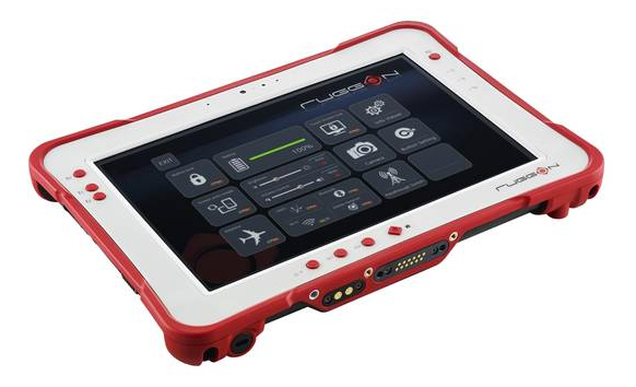
    Taiwan-based company RuggON is launching the Rextorm series of rugged tablets. With an ultra-bright 1000 Nit optically bonded display, high speed 802.11ac connectivity, hot swappable dual-battery design, and capacitive glove touch capability, the 10.1-inch fully ruggedized tablets are ready for use in the field.

    With the latest communication technology including GNSS Positioning (GPS/GLONASS/Beidou), 802.11 ac, Bluetooth 4.0 and optional 4G LTE, mobile workers can experience precise positioning, fast processing, broad coverage and more stable data transfer even around buildings or trees, RuggON said. For in-vehicle usage, a dual pass-through port allows users to connect via vehicle dock for improved GNSS, WLAN, or WWAN reception. Standard I/O ports include USB 3.0, 2.0, RS232, RJ45, Micro-HDMI, and Micro-SD.

    The Rextorm series is a fully ruggedized tablet that meets and exceeds MIL-STD-810G standards for shock and vibration, offers IP65 rating, wide operating temperature range and superior drop resistance of 5 feet on to a concrete surface.

    Using the Intel Core i5 Haswell processor, the PX-501 has the fastest processor of the series and is a rugged workstation that can be taken to the field. High-capacity 120GB or 240GB SSDs are available, as well as 4GB or 8GB of DDR3 RAM. A precision digitizer allows accurate input for illustrations and technical work in the field. Windows 7/8 Pro as well as Windows Embedded 7/8 are available.


  • Telematics Detroit Changes Name to Reflect Shift to Autonomous Cars

    Telematics Detroit, the connected car event, has officially changed its name to TU-Automotive Detroit to reflect the paradigm shift in auto mobility. The event will take place June 3-4 at The Suburban Collection Showplace in Detroit.

    The name change to TU-Automotive Detroit is intended to reflect how “automakers are evolving from heavy manufacturers into nimble technology companies and the self-driving car is moving from the realms of science fiction onto the reality of our highways. The car as we know it is rapidly changing,” organizers said in a statement.

    Experts will provide overviews in three core areas of telematics, mobility and autonomous cars.

    “Anticipating the future trends of the automotive industry is exactly what this conference has always been about,” said Justin Parker, project director. “Accordingly, the new angle of the show addresses the headline topics of mobility and autonomous vehicles.”

    Key topics:

    • Telematics – the here and now: Consider the building blocks of the connected car that continue to present challenges and opportunities such as the ultimate user experience, the connected society and the aftermarket. It is these foundations that are paving the way for the future of auto-mobility.
    • Auto-mobility: The role of the car is changing. From new ownership models to sustainable transportation and smart cities, get to grips with the technology and societal changes that are fundamentally reshaping mobility.
    • The autonomous car: Sensors, lasers, ADAS and regulators. The end-goal of the self-driving car is an exciting amalgamation of regulatory and technological developments. We’re deep into the journey of the autonomous car and now is the time for the industry to come together to collectively take the next step.

    Get the latest updates and information and register for the brochure with full speaker line-up and agenda.


  • By 2020 Connected Cars Will Mean In-Vehicle Services, Automated Driving

    By 2020 a quarter billion connected vehicles will be on the road, enabling new in-vehicle services and automated driving capabilities, according to Gartner, Inc. During the next five years, the proportion of new vehicles equipped with this capability will increase dramatically, making connected cars a major element of the Internet of Things (IoT).

    Gartner forecasts that 4.9 billion connected things will be in use in 2015, up 30 percent from 2014, and will reach 25 billion by 2020.

    “The connected car is already a reality, and in-vehicle wireless connectivity is rapidly expanding from luxury models and premium brands to high-volume midmarket models,” said James F. Hines, research director at Gartner. “The increased consumption and creation of digital content within the vehicle will drive the need for more sophisticated infotainment systems, creating opportunities for application processors, graphics accelerators, displays and human-machine interface technologies. At the same time, new concepts of mobility and vehicle usage will lead to new business models and expansion of alternatives to car ownership, especially in urban environments.”

    Gartner forecasts that about one in five vehicles on the road worldwide will have some form of wireless network connection by 2020, amounting to more than 250 million connected vehicles. The proliferation of vehicle connectivity will have implications across the major functional areas of telematics, automated driving, infotainment and mobility services.

    More detailed analysis is available in the Gartner report “Predicts 2015: The Internet of Things.”

  • NGA Director Says Agency Seeks Further Industry Engagement

    NGA Director Robert Cardillo.
    NGA Director Robert Cardillo.

    Robert Cardillo, director of the National Geospatial-Intelligence Agency, highlighted potential areas for collaboration between the agency and industry during a speech Jan. 21 at the Intelligence and National Security Alliance leadership dinner.

    GEOINT organizations should cooperate to democratize geospatial information, deliver more anticipatory intelligence, and boost data security through identity and access management, Cardillo said. He cited NGA’s new online portal GEOINT Solutions Marketplace, which allows professionals to share their ideas with the NGA.

    According to Cardillo, two factors are driving the democratization: the rapidly spreading geography of the Internet and the “darkening of the skies” by small sats and new airborne collectors.

    “First, the rapidly spreading geography of the Internet — as more people carry more handheld devices to more places – and the emerging Internet of Things demonstrate what you and I have long known: Everything, everyplace, everyone exists in a time and a place. Their dependence on their georeference makes what we do — spatio-temporal analysis — the bridge to the future of commerce, cooperation, transparency and security. We look at questions from a broad geographic point of view. We use geospatial data to analyze questions with scientific methods that give unique perspectives grounded in reality.

    “Second, the skies — really space — will darken with hundreds of small sats to be launched by Skybox, Planet Labs, BlackSky and others. The questions that arise from the persistence of geospatial data streaming from hundreds of satellites covering the earth multiple times a day are staggering. The challenges of taking advantage of that data are daunting. We cannot afford — nor need — to store it all, so will we have to go to an “imagery as a service” model and buy only what we need when we need it? This will be less about the images and more about the derived information or analytics.”And these are only the beginning of the questions we must answer — or even know to ask — about the impact of the small sat revolution. What questions can we answer with daily coverage of the planet? What choices will our adversaries make with daily coverage of the planet? How will we maintain decision advantage in such a playing field?”

    Despite the security challenges, he said the NGA aims to take an active role to maintain public confidence in the intelligence community’s efforts to safeguard privacy and security. He also credited the agency for its work to provide digital access to Ebola-related unclassified information, encourage development of geospatial applications through open sourcing and crowdsourcing programs.

    For Cardillo’s full remarks, see this page.

  • UBL Interactive Enters Data Agreement with NavAds for GPS Locations

    UBL Interactive, Inc. today announced a global data syndication agreement with Amsterdam-based NavAds to help businesses ensure their profiles appear in navigation services and devices.

    The NavAds agreement will improve the quality of the business listing information and the breadth of distribution for UBL customers. NavAds specializes in business listing insertion and advertising on navigation services such as TomTom, Garmin, Nokia HERE, Waze, Yandex, and others.

    UBL CEO, Doyal Bryant, said the partnership was significant not only because it addressed the growing use of mapping tools, but because it was a global arrangement. “UBL is focused on an increasingly mobile world, and services which are not confined by national borders. Navigation services are constantly changing and evolving and with our NavAds partnership, our customers can be assured anywhere globally, they will get the benefit of the most advanced distribution in the mapping space,” he said. “It extends our place as the global leader in business listing syndication, with more publishers and international local partnerships than any others in the space.”

    NavAds CEO, Lex ten Veen, said UBL would bring many new owner-verified business locations to the NavAds platform and network. “Businesses need to be found on these navigation devices, and NavAds can give UBL’s customers great confidence their visibility is fully optimized,” he said.

    The services will be integrated into UBL product sets immediately.

  • Esri Story Map Asks Which Super Bowl Team Has Better Fans

    With the big game right around the corner, Esri is taking a closer look at the fan-bases supporting the Seattle Seahawks and the New England Patriots in Super Bowl XLIX.

    Using demographic data, an interactive story map compares the Seattle and Boston metropolitan areas across five different sports variables, from buying apparel to tracking sports information on their phones. See which city comes out ahead in this Super Bowl of geography and demographics.

    Here’s the map.

  • Trimble Unity Replaces Connect for Water, Wastewater and Stormwater Utilities

    Trimble Unity Replaces Connect for Water, Wastewater and Stormwater Utilities

    Trimble-unity-Hardware
    Photo: Trimble

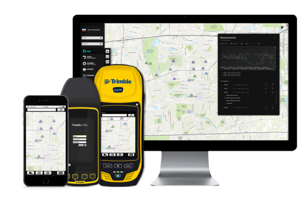
    Trimble introduced today its next generation suite of software applications for water, wastewater and stormwater utilities — Trimble Unity. Trimble Unity replaces Trimble Connect for Water and offers a unified cloud-based and mobile collaboration platform for smart water mapping and work management.

    Trimble Unity applications, or “apps,” support the following workflows:

    • Mapping: Field and office GIS visualization and mapping of assets with up to centimeter-level accuracies
    • Maintenance: GIS-based asset maintenance and inspection forms and business processes
    • Service: Customer field service work order and mobile workforce management
    • Metering: Smart water meter deployment, installation and maintenance
    • Monitoring: Visual and real-time monitoring of field operations and utility networks
    • Analytics: Dashboards and performance management reporting

    Trimble Unity represents a unified collaboration platform for managing critical utility assets and the work of water industry professionals. By integrating GIS and field operations, sensors and wireless communications, mobile workers and office professionals, field and back office enterprise systems, and utilities with their contractors, Trimble Unity provides the water industry with a comprehensive solution for regulatory reporting, improving operations, reducing cost and enhancing customer service, the company said.

    Trimble Unity is designed to automate a variety of industry workflows through individual “apps” offered within the software suite, enabling utilities to deploy smart meters, assess the condition of assets, repair leaks and reduce non-revenue water (NRW), and locate and map critical infrastructure using Trimble high-accuracy GNSS mapping technologies. The software can also assist utilities in reducing spills and environmental damage, extending the life of aging assets and helping improve worker safety and productivity.

    Through a Trimble Unity software-as-a-service (SaaS) subscription, organizations can provide a single solution for the office and the field, choosing any combination of Trimble and non-Trimble mobile devices, including iOS, Android, Windows Mobile and Windows 7/8 smartphone, tablets and laptops. The software also integrates the latest Esri ArcGIS Server, mobile and ArcGIS Online map services enabling organizations to leverage their existing investments in GIS technology.

  • Snowed in? Track Your City’s Snow Plows with GPS Apps

    Snowed in? Track Your City’s Snow Plows with GPS Apps

    PlowNYC-W
    Photo: PlowNYC

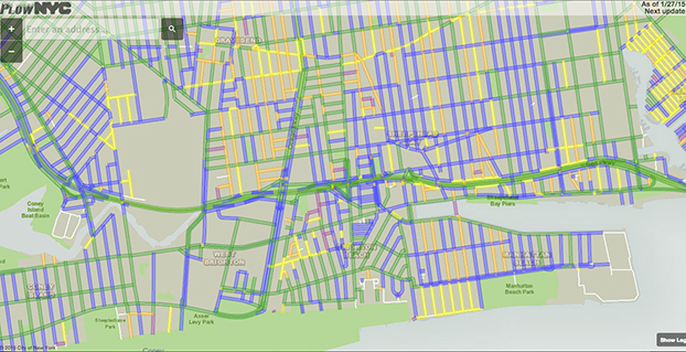
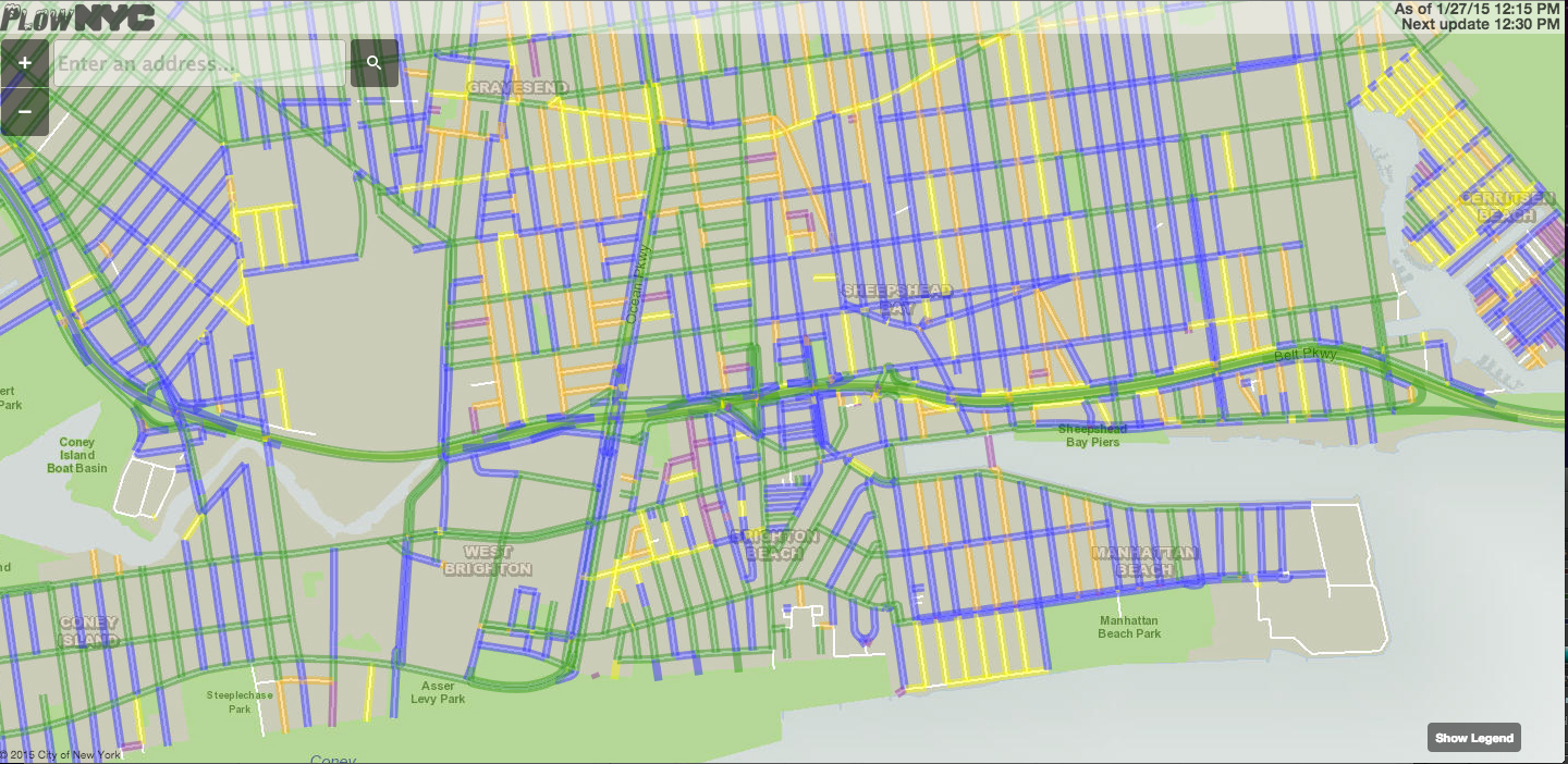
    Snow plows in many cities cleaning up the snow from a winter storm that blasted the Northeast are being tracked with GPS. One website application, PlowNYC, provides real-time updates on where the plows are in the Big Apple, according to CBS News. PlowNYC was developed by Rastrac, a GPS fleet tracking and remote asset management solution company.

    The New York City sanitation department is deploying 2,550 plows and more than 2,400 workers to combat the storm. “The city actually tracks all the snow plows and aggregates all of that information and make it available to New Yorkers on this map,” data scientist Ben Wellington told CBS News. “Green lines on the map show the roads that have been plowed in the last hour whereas the blue line shows the streets that have been plowed in the last one to three hours.”

    New York isn’t the only city applying this kind of technology. For the first time, Pittsburgh residents can track their plows in real time. Chicago has been sharing it’s plow data for the last several winters.

    “I think for the public, it gives them a sense of security to see where things are happening and feel like they can hold us accountable,” New York City sanitation commissioner Kathryn Garcia told CBS News. “At the end of the day, we work for them.” The apps also reduce the number of calls to city call centers.

  • Funding Proceeds for More GLONASS-K1 Satellites

    News courtesy of CANSPACE Listserv.

    According to its in-house newspaper, Siberian Satellite, the joint-stock company “Information Satellite Systems – Academician M.F. Reshetnev” has signed two loan agreements with the Russian VTB Bank (formerly Vneshtorgbank) worth 2.5 billion rubles ($38 million) to finance the production of GLONASS-K navigation satellites.

    Presumably, this refers to the decision to produce more GLONASS-K1 satellites as recently announced.

    The Russian government owns 61% of VTB.