LoJack Corporation is collaborating with Novatel Wireless to develop robust positioning and accuracy capabilities in the LoJackConnect for Inventory Management system. The system helps sales personnel at dealerships accurately track and actively monitor vehicle inventory across multiple lots, helping to minimize the time required in the regular dealer inventory process. Accessible via computer, tablet and mobile phone, users can verify vehicle location, access relevant vehicle information, track test drives and receive early warning alerts if a vehicle is moved from a geofenced location.
LoJack Connect for Inventory Management is powered by the Novatel Wireless 3060 OBDII solution for HSDPA/GSM/GPRS. The MT 3060 is a specialized OBD II telematics solution that offers advanced technology and a sophisticated feature set, combined with high quality and compatibility testing standards, Novatel Wireless said. With dual accelerometers, GNSS support, an open platform, and the N4A Content Cloud Management System, the MT 3060 enables LoJack to offer a reliable telematics solution to dealerships nationwide.
REAL 2015: Capture, Compute, Create will be held Feb. 25–26 at Fort Mason Center in San Francisco. REAL is designed to explore the professional 3D sensing, creation, and visualization industries. It includes an executive summit and a world’s fair of cutting-edge 3D demonstrations, and is organized by Autodesk.
According to organizers, “From drones to autonomous cars, industrial robots to major engineering works, and game consoles to tomorrow’s mobile phones, 3D sensors are suddenly everywhere. And several decades after first grabbing headlines, VR and 3D printing are hot again, attracting billions in investment, and moving beyond early adopters to professionals. But it is the sum total, where sensing meets making, where big change is brewing.”
Sponsors include Leica Geosystems and Topcon. Two Topcon experts will speak at the event: Jason Hallett, Topcon vice president of global product management, and Eduardo Falcon, executive vice president and general manager of the GeoPositioning Solutions Group.
“The Topcon line of advanced 3D imaging and mapping technologies are designed for a wide range of geospatial applications providing data-rich results,” Falcon said. “REAL 2015 presents opportunities to explore how our mobile and static scanning solutions can be utilized in forward-thinking ways, as 3D sensing and reality capture continue to permeate traditional and non-traditional industries alike.”
Through its support for OGC specifications, ArcGIS users can access data and services from many different sources, regardless of the technology used by those sources, Esri said. In addition, users can share their content with others, including non-Esri users, contributing to the larger goals of the open data movement.
“Our goal is to help our users be successful, and Esri sees technical interoperability as a key driver to successful implementations,” said Dr. Satish Sankaran, Esri product manager for interoperability and member of the OGC Architecture Board.
The OGC leads the development of geospatial interoperability standards. Esri is a long-standing, active OGC participant, helping GIS users to seamlessly work together, Esri said.
Esri’s first OGC compliancy certificates were granted in 1999, and many more Esri ArcGIS platform products have met OGC compliancy since then.
The House Science, Space, and Technology Committee held a hearing Jan. 21 on the integration of commercial unmanned aerial vehicles in United States airspace. Colin Guinn, senior vice president of sales for 3D Robotics, demonstrated the Parrot Bebop drone during his testimony.
C-SPAN aired the event, as reported by the National Journal. Congress has tasked the Federal Aviation Administration with readying airspace for the integration of commercial drones. Drones are currently prohibited for use, but the FAA has granted a growing number of exemptions for certain industries, including an exemption to GNSS company Trimble for its UX5 drone.
Also, earlier this month, CNN signed a research agreement with regulators to test drone systems for news-gathering purposes.
Two new products have found ways to turn smartphones into personal protection devices. One of the two products includes a wearable monitor.
Photo: First Sign Technologies
Mace Wear Pod
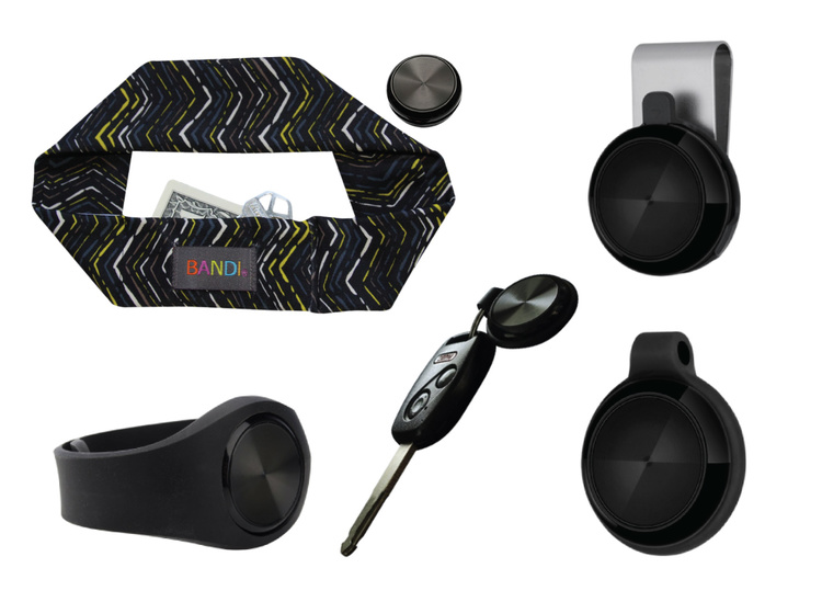
The Mace Wear Pod uses a wearable device in conjunction with a smartphone app. First Sign Technologies, in partnership with Mace Wear, has launched the Mace Wear Pod, which acts as a personal security system against violent crimes. At the first sign of a violent attack, an assault alarm is activated and the speaker lets the attacker know that evidence has been collected and help is on the way. The device automatically begins to collect evidence, take photos, and call for help, which will help identify, apprehend, prosecute and deter attackers, the makers say.
The Mace Wear Pod can be worn in five ways as a headband, wristband, key chain, belt clip and pendant. For those not wearing the pod, the mobile app, which can be downloaded on iPhone and Android, can also be activated in three ways, by hitting the alert button, by shaking your phone, or by setting a time to check-in — the alarm is activated if the check in doesn’t take place.
First Sign Technologies was launched in January 2014. Following a successful crowd-funding campaign, the product is now available with one year of monitoring service for $120.
“There is a demand for personal protection and with the advances in wearable technology, we want to create products that give peace of mind,” said First Sign President Rachel Emanuele. “Mace is an ideal partner to help us expand our product line and help promote safety to all who seek it.”
The products are expected to be available in more than 1,000 stores such as Dick’s Sporting Goods, Sports Authority and Sears. Demonstration videos are posted here.
Photo: STOP-ATTACK
STOP-ATTACK
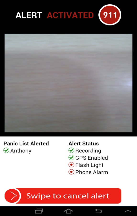
Another new app launching this month, STOP-ATTACK, uses smartphone technology to send alerts in case of bullying or harassment. STOP-ATTACK, available on both Android and Apple platforms, records audio and video evidence and alerts contacts of trouble in a matter of seconds, sending GPS coordinates to a designated Panic List and first responders.
“We need to stop the senseless violence and assaults in this world,” said Anthony “Tony” Bright, the creator of STOP-ATTACK. “Our hope is that STOP-ATTACK.com will be a powerful tool in this struggle. The app has been developed with simplicity as a core feature, so that even younger children can be protected, giving parents much-needed peace of mind.” The CEO will be presenting the STOP-ATTACK app at the Pre-Grammy Awards VIP Gift Lounge and The Oscars Gift Lounge hosted by GBK productions this February.
The app can be downloaded in the Google Play or iTunes store, and is available for free now until Feb. 8, 2015.
STOP-ATTACK users will be able to customize many aspects of the app, such as creating a “Panic List” of people for the app to contact in an emergency, from friends and family to local first responders. When a user activates STOP-ATTACK, the app instantly begins recording live audio and video and uploading the stream to the cloud. Panic List contacts and designated first responders are notified immediately or after a brief, user-determined delay. The app will send the contacts a link with the GPS location and the recording of the incident.
A hot key allows for quick and discrete activation of the STOP-ATTACK app. For instance, a bully need not know they’re being recorded until presented with the evidence by a school authority. On the other hand, it’s sometimes advantageous to let everyone know that STOP-ATTACK is recording; users can choose for the app to play an alarm sound and turn on the camera light when activated, a strong deterrent to a would-be attacker.
The developers of STOP-ATTACK have created a pair of explainer videos to showcase exactly how the app works in typical usage scenarios: “Always Be Prepared,” “Bullying.”
Esri’s interactive Severe Weather Public Information Map and U.S. Snowfall Forecast Map enable users to see winter storms, including the massive storm that’s about to hit the Northeastern United States. Here are the two maps.
Severe Weather Public Information Map
With the Severe Weather Public Information Map, users can view continuously updated weather reports and warnings from the National Oceanic and Atmospheric Administration (NOAA) and the National Weather Service, along with live weather data from AccuWeather.
Users can also explore geotagged social media from Twitter, Flickr, and YouTube related to the storms.
U.S. Snowfall Forecast Map
This map shows the projected accumulation of snowfall across the U.S. for the next 36 hours, using data from National Weather Service Digital Forecast Database. Users can step through projections in six-hour increments for a more accurate view of when and where snowfall is expected to be most severe.
The U.S. Cluster Mapping website provides research in clusters combined with 52+ economic indicators, forming an online, open-data, open-source platform that allows users to make more informed decisions about economic development, both in the United States and abroad.
The website is evolving to serve as the national portal to track cluster-led economic development efforts, identify best practices, and spread new data and insights. The interactive webinar will walk participants through use the tool and show how best to use it.
The U.S. Cluster Mapping Project is a national economic initiative that is led by Harvard Business School’s Institute for Strategy and Competitiveness (ISC) in partnership with the U.S. Department of Commerce and U.S. Economic Development Administration. Directed by Michael Porter, the ISC studies competition and its implications for company strategy; the competitiveness of nations, states, and regions; and solutions to social needs such as health care, innovation, and corporate responsibility.
Speakers include Sarah Jane Maxted, the U.S. Cluster Mapping Project manager at ISC focusing on clusters and regional economic growth, and Christian Ketels, ISC principal associate and research team leader.
San Francisco-based startup Planet Labs has raised $95 million from investors in its latest round of financing. The company’s goal is to provide frequent, inexpensive, high-quality Earth imagery to a variety of customers.
“I’m pleased to announce a first closing of a planned $70 million Series C round led by Data Collective. This financing includes a debt facility of $25 million from Western Technology Investment, bringing the total financing to $95 million,” said co-founder and CEO Will Marshall.
Planet Labs builds Earth-observation satellites that are a mere 12 x 4 x 4 inches. Each of the miniature satellites, which the company calls “Doves,” can capture imagery with a resolution of 10 to 16.5 feet (3 to 5 meters).
Planet Labs, founded in 2010 by three former NASA scientists, has launched 73 Doves into orbit. The first prototypes blasted off in April 2013. In January 2014, Planet Labs delivered Flock 1, a constellation of Earth-imaging satellites made up of 28 Doves. Subsequent launches have increased the current constellation to 71 Doves. The goal is to be able to image the entire Earth every day.
Doves being deployed from the International Space Station. Photo: NASA
Once the satellites are operational in orbit, they each complete a full circuit of the planet in about 90 minutes, capturing images as they travel. When a satellite makes contact with a ground station in the company’s network, Planet Labs receives images and migrates them to the cloud, as well as transmitting additional instructions to the satellites.
According to the company website, Planet Labs provides commercial and humanitarian value with its global imaging network. Industries supported include geospatial, agriculture, civil government, and natural resources. “Fresh data from any place on Earth is foundational to solving commercial, environmental, and humanitarian challenges,” the website said. “Our global sensing and analytics platform unlocks the ability to understand and respond to change at a local and global scale.”
Planet Labs says it provides the industry’s most frequently updated imagery of any place in the world at 3-5 meter resolution. The data supports customers who need easily accessed, fresh imagery to inform their day-to-day operations, data analysis, and products. Each image is processed through the company’s automated data pipeline and delivered to customers via API and web tools.
“This financing comes in the wake of our successful launch of 73 satellites, customers actively using our data, and the recent hiring of Tom Barton as our chief operating officer. Tom was formerly CEO of Rackable Systems (now SGI) and boasts over 25 years of experience managing and advising hardware and software companies,” Marshall posted on the Planet Labs website. “With strong support from new and returning investors, Tom on board the management team, and a brand new headquarters in the heart of San Francisco, we’re primed to deliver more insights about our changing planet in 2015.”
The Dawesville Channel in Western Australia as seen by a Planet Labs satellite. Photo: Planet LabsThe Kashima Industrial Zone is one of the Japan’s largest industrial parks, home to an estimated 1,500 factories. The plant at the image’s center manufactures steel sheets found in home appliances and auto parts. A low-density residential area (upper left) lies just west of the industrial zone. Photo: Planet Labs
Navman Wireless is launching an integrated vehicle tracking and camera technology product aimed at helping businesses manage risk, improve road safety, and reduce insurance costs. The product, labeled “360 Degree,” integrates telematics, vehicle tracking technology and in-cab safety camera equipment to create what Navman calls a “seamless umbrella of preventive and protective technology.”
The system is designed to help mitigate poor driving, reducing on-the-road risk. “Prevention is better than cure, and using data from telematics and vehicle tracking software to help mitigate poor driving significantly reduces on-road risk, but when you are on the road you need 360 degrees of protection,” said Hutchins.
Navman Wireless describes the in-cab safety camera equipment, supplied by Smart Witness, as a safety net. “It’s a last line of defense for drivers and fleet businesses in those unfortunate circumstances beyond their control,”said Scott Hutchins, VP sales UK and Ireland, Navman Wireless. “The introduction of in-cab camera technology not only protects the driver and business from not-at-fault claims, but also enables us to offer a complete proactive and preventative solution that has the potential to deliver measurable improvements in terms of accident and cost reduction.”
“It’s about prevention and protection. Telematics technology is integral to a successful preventive safety strategy because it can be effectively utilized to assess drivers and ensure safety and quality,” Hutchins said.
Ardent Management Consulting (ArdentMC) has been awarded a five-year Indefinite Delivery/Indefinite Quantity (IDIQ) from U.S. Geological Survey in support of the Federal Geographic Data Committee (FGDC).
The task orders on the IDIQ are to provide a full range of application and service design, development, and maintenance support for the FGDC as the coordinating interagency body for the Geospatial Platform (GeoPlatform). Among awards to other companies, ArdentMC was awarded a one-year, $1 million task order on the IDIQ to provide FGDC with GeoPlatform programmatic support.
The GeoPlatform is an Internet-based capability providing shared and trusted geospatial data, services, and applications for use by the public, government agencies and partners to meet their mission-critical needs. According to Ardent, it embodies the principles and spirit of Open Government, emphasizing government-to-citizen communication, accountability and transparency.
“ArdentMC is very excited about partnering with FGDC, its member agencies and the geospatial community to support the management and collaboration of geospatial data sharing and provide a mission tool that is accessible and easy to use by stakeholders at the federal, state, local and private sector levels,” said Brandon LaBonte, ArdentMC president and CEO.
LoJack is introducing at NADA 2015 its Fleet Management Lite offering, a new version of the service designed to be an affordable, turnkey SaaS (software as a service-based) telematics solution. Fleet Management Lite will enable business owners with small- to medium-sized fleets to realize the benefits of an advanced fleet telematics system, LoJack said. The can be quickly deployed, making it a good choice for loaner vehicle fleets in many of today’s dealerships, the company said.
Another location-based program is LoJack Pre-Install, which enables automotive dealerships to pre-load vehicles in their inventory with the LoJack Stolen Vehicle Recovery System before the vehicle is sold to the customer.
“Our commitment to LoJack’s dealership network is at the center of who we are as a brand and a company,” said Randy Ortiz, president and CEO of LoJack Corporation. “Through a combination of strategic partnerships and corporate research and development, we’re fully invested in our mission to deliver sophisticated and reliable connected car and telematics solutions to the dealership community. Our goal is that each of these solutions enables dealerships across the country to increase revenue and improve operational efficiencies while effectively serving customers.”
Water management company DHI used satellites to map Jan. 11-13 floods in Denmark.
On the weekend of Jan. 9-11, two storms passed over Denmark. During and after the storm flood warnings were issued in different areas of the country. To monitor and map the spatial extent of the flooding DHI GRAS asked Airbus Defence and Space to acquire TerraSAR-X satellite images over the areas. DHI then analyzed and mapped the flooded area.
The main advantage of using radar satellites like TerraSAR-X is the ability to acquire images independent of weather and light conditions, DHI said. It is possible to get an image of the actual conditions on the ground even during harsh winds (up to 35 to 40 meters per second in this case), massive clouds and rain, and during the night.
The illustration below shows parts of the flooded area around Limfjorden in Northern Jutland, Denmark. On the background radar satellite image the water is black while land area appears in white and grey tones. The light blue overlay indicates flooded areas.
The images were acquired over various parts of Denmark. By preparing and reacting to future and similar early warnings of flooding and storm events, it is possible to plan for new images to be acquired during the maximum extent of the water level.