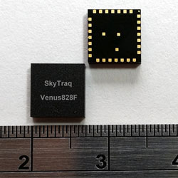
The SkyTraq Venus828F GNSS receiver module. Photo: SkyTraq Technology
SkyTraq Technology has introduced a stand-alone multi-GNSS receiver module in a compact 7 x 7 millimeter form factor, the Venus828F, designed with a sensor hub function for wearable and “Internet of Things” (IoT) applications.
The Venus828F is capable of communication with multiple satellite systems and tracking up to 28 satellites concurrently, SkyTraq said. The compact LGA module integrates all the necessary components for wearables and IoT, forming a complete working GNSS receiver, including GNSS chipset, 0.5ppm TCXO, Flash memory, LDO regulator, DC/DC switching regulator, and passive components. It only requires external antenna and power supply to output accurate position, velocity, and time information in standard NMEA-0183 format, enabling ease of use and fast time to market, Skytraq said.
The Venus828F features low power consumption, a 29-second cold start TTFF, -165 dBm tracking sensitivity, 10 nsec 1 PPS timing accuracy, on-board geofencing, 8 Mbit – 512 Mbit external SPI Flash data logging, and an industrial operating temperature range of -40C +85C. It has an UART and I2C interface for flexible connection to the host processor.
Via SPI and I2C connection, data from MEMS sensor can be calculated by Venus828F using sensor-hub-enabled firmware, offloading computation from the host processor. Engineers can concentrate on their wearable and IoT applications instead of spending hundreds of hours reinventing the wheel developing sensor-fusion algorithms, according to SkyTraq.
“Fast-acquisition high-sensitivity multi-GNSS chipset hardware are just becoming available in recent years, the internal firmware supporting multi-GNSS typically are not as fully optimized as GPS-only firmware that has matured for more than a decade to allow ROM codification with optimal performance for any existing GNSS chipset vendors; the multi-GNSS firmware is still being continuously improved over time,” said Michael Chung, VP of sales and marketing, SkyTraq. “By offering Venus828F multi-GNSS receiver module with Flash memory, it’s shipped with the latest, best-performance firmware. It is also later upgradeable in the field if the customer’s design allows. Targeting very high volume, cost-sensitive wearable and IoT applications, Venus828F is offered at price comparable to crystal-based ROM GPS modules on the market, setting a new benchmark in terms of performance, size, and cost for multi-GNSS receiver modules.”
An engineering sample, datasheet, and reference design for the Venus828F are available now.
Big Market Research is offering a “2014 Market Research Report on Global GPS Antenna Industry” that discusses the world’s major regional market conditions for antennas, including North American, Europe and Asia, and the countries Germany, Japan, China, and the United States, among others.
The report introduces basic GPS antenna information, including antenna definition classifications and applications, and an industry-chain overview; GPS antenna industry policy and plans; GPS antenna product specification; and the manufacturing process and cost structures. Then the analysts look at regional market conditions, including product price, profit, capacity, production, capacity utilization, supply, demand and industry growth rate.
The report introduces a GPS antenna new project SWOT analysis, investment feasibility analysis, investment return analysis, and the global GPS antenna industry.
The report has six parts:
basic product information;
an analysis of the Asian GPS antenna industry;
an analysis of the North American GPS antenna industry;
an analysis of the European GPS antenna industry;
an analysis of the entry-level market and investment feasibility;
GeoOptics, a satellite-based environmental data services company, in cooperation with Atmospheric and Environmental Research (AER), an environmental research and development company, has announced the initial results of an Observing System Simulation Experiment (OSSE) showing the reliability of radio occultation data in improving predictions of severe weather and flash flood events.
Using weather prediction models and data assimilation techniques, AER evaluated the potential benefit of observing Earth’s atmosphere with a vast future constellation of many hundreds of orbiting GNSS – Radio Occultation (GNSS-RO) receivers. As a case study, the model used the convective system that brought severe weather to Oklahoma in 2013, which included an Enhanced Fujita Scale-3 tornado and heavy rains.
“The improved characterization of moisture in the lowest 4-5 km of the atmosphere is very significant and, working with our colleagues at AER, we believe quite a rigorous scientific conclusion,” said Conrad Lautenbacher, GeoOptics CEO. “We see commercial provision of GNSS-RO as a valuable complement to public sector systems and a reliable, low-cost way to achieve the levels of scale tested. We are very excited by the results.”
Through collaboration begun in 2014, the two companies set out to assess the impact of vastly increased numbers of GNSS-RO profiles on regional weather forecasting within the context of a global weather satellite system. Oklahoma was the region of focus of the study, an area with a history of severe weather phenomena. Today’s total global GNSS-RO profiles number approximately 1,800 per day, of which 0.64 profiles per day are readings taken over Oklahoma.
In the study, AER and GeoOptics modeled from 50,000 to 2,000,000 global profiles per day through the deployment of the planned CICERO satellite constellation. Such large scale would correspondingly increase the profiles per day over Oklahoma to between 17 and 700.
“We see commercial remote sensing and particularly the GNSS-RO technology as a paradigm change in developing and maintaining a cost-effective, next-generation operational observational infrastructure for environmental prediction,” said AER President Ron Isaacs. “The superb GNSS-RO technology knowledge base at GeoOptics provides an ideal and exciting complement to AER’s decades-long experience in today’s operational remote sensing and weather prediction practices, which include the current use of GNSS-RO sensing.”
GNSS-RO profiles provide measurements of atmospheric temperature, moisture, and pressure with a precision unrivaled by other space-based techniques. The RO sensor gathers this information by precisely observing perturbations imposed on ubiquitous GPS radio signals as they pass through the atmosphere. Today, nearly 3,000 organizations in more than 80 countries use RO data in Numerical Weather Prediction (NWP) and research. NOAA’s own studies show that more accurate mid- to long-term forecasts can be made up to 15 hours sooner using the data collected from the current limited set of experimental GPS-RO sensors.
GeoOptics plans to launch an array of powerful GNSS-RO sensors on its CICERO constellation of low-Earth-orbiting satellites. The rollout of the constellation will begin in the third quarter of 2015 and will deliver more than 50,000 global profiles per day when fully deployed. As demand grows, the 24-satellite CICERO constellation will be expanded to carry additional and complementary instruments, such as scatterometry and gravity sensors.
“GeoOptics will advance a small satellite observing model that starts with GPS radio occultation,” Lautenbacher added. “We believe an integrated private company like ours can deploy such systems for a fraction of current costs to the government.”
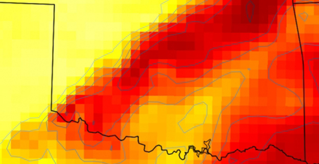
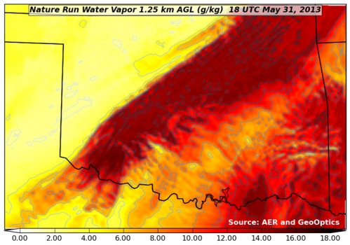
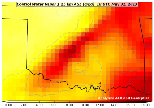
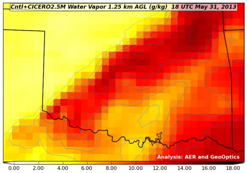
Figure 1. “Nature Run” (the truth reference) atmospheric water vapor at about 4,000 feet above the ground. The yellow-to-red color scale (bottom of figure) indicates how much water vapor is present, i.e., yellow is dry and red is moist. This realization of atmosphere moisture during an Oklahoma severe weather outbreak in May 2013 is the yardstick against which our assimilation experiments are compared for realism. It has a horizontal resolving power of about 1 1/4 mile (i.e., 2 km).Figure 2. Atmospheric water vapor analysis using conventional observing system. Valid time, vertical level and color scale are the same as in Figure 1. Note that the data fusion experiments use a bigger grid than the Nature Run (Figure 1) with a horizontal resolving power of about 11 miles (i.e., 18 km).Figure 3. Atmospheric water vapor analysis using conventional observing system + CICERO radio occultation observations. The distribution of water vapor in this analysis is much closer to the Nature Run (Fig. 1) in pattern and magnitude than the Control result (Fig. 2).
We’ve changed the way subscribers can access the digital edition of our monthly GPS World magazine.
Digital subscribers can access the digital edition by an email notification that will appear in their inbox. Just click on the link provided. Accessing the digital edition this way is easy — you won’t need to enter your subscriber number.
However, if you need to know your subscriber number, you can access it from the email notification.
Print subscribers can also access the digital version of the magazine by entering their subscriber number when prompted. Your subscriber number can be found on the label of the printed magazine or within the digital email notification. See sample image below.
Photo: GPS World
When accessing the digital edition from the website, a newsletter, or the iTunes or Google Play store, you may need to enter your nine-digit subscriber number. Any subscriber may access the content as long as he or she subscribes to the monthly magazine — either the print or digital format.
If you are not yet a subscriber to the monthly magazine, signing up is easy and, in most instances, free for anyone working in the GPS/GNSS industry. Simply complete the online subscription form.
The first few pages of each monthly digital edition is available as a preview. When the maximum number of views is reached, the reader will receive a prompt to enter the subscriber number.
Jan. 6 was the last day of service for GPS satellite SVN-26. SVN-26 was a Boeing/Rockwell International Block II GPS satellite launched July 7, 1992. It was one of the first generation of operational GPS satellites, and had a design life of only 7.5 years. On Jan. 7, SVN-26 (PRN-26) was transferred from the operational ground control system (AEP) to Launch, Anomaly and Disposal Operations (LADO).
CGSIC Executive Secretariat Rick Hamilton, USCG Navigation Center, remarked on its longevity. “A testament to the satellite engineers and the men and women of the Air Force, the Second Space Operations Squadron at Schriever Air Force Base has successfully managed SVN-26 in its mission for over 22 years.”
In the near term, PRN-26 will be used for clock checkout activities on a few LADO satellites. The compatibility test for SVN-71, the next IIF satellite to launch (SVN-71/IIF-9), is scheduled for the week of Jan. 19. PRN-26 will be used by SVN-71 for the compatibility test, and then be used again for LADO satellite clock tests.
PRN-26 will be reassigned to SVN-71 just before launch from Cape Canaveral on March 25.
Trimble has introduced TerraFlex Advanced, an enhanced edition of its TerraFlex field data capture software, which manages asset collection and update activities for everyday geospatial requirements. Organizations across a variety of industries, including environmental management, utilities and government agencies, can deploy a common workflow for field workers to collect or inspect their assets efficiently using TerraFlex Advanced.
TerraFlex Advanced enables GIS professionals to stay productive by keeping their data and devices up-to-date and organized. It allows users to import existing assets or GIS data into their TerraFlex projects and make real-time updates to the data in the field. The information can be shared across the project organization, so all project members — from the field to office — are working with the most up-to-date data available.
In addition, a new version of the TerraFlex Mobile apps supports Trimble RTX technology-based correction services. Trimble RTX (Real Time eXtended) is a high-accuracy GNSS correction technology that delivers repeatable centimeter-level positioning worldwide to compatible GNSS receivers. GIS professionals now have more flexibility to achieve the accuracy required by their highly mobile workflows in real-time, without being tied to a base station or local VRS network.
With TerraFlex Advanced, users can collect, process and manage geospatial data quickly and efficiently across a fleet of mixed consumer and professional data collection mobile devices and platforms. Local governments who require regular data updates on city assets, utility workers performing frequent inspections on infrastructure, and many other mapping and GIS organizations can update new and existing data while in the field much faster.
“In today’s environment, asset conditions are constantly changing and access to real-time information about these assets is crucial to decision-making and sustainability of those assets,” said Alain Samaha, business area director of GIS and Software for Trimble’s Geospatial Division. “TerraFlex Advanced addresses this growing requirement by ensuring GIS field crews are equipped with current information so they can make informed decisions, avoid costly rework, and plan and schedule resources efficiently for the maintenance of assets.”
Part of the Trimble InSpherecloud-based software platform for the management of geospatial applications, data, and services, TerraFlex Advanced extends the robust project, user and form functionality in the original TerraFlex Basic edition, keeping field crews organized and productive on a variety of devices and in a wide range of environments.
In addition to TerraFlex Advanced software, Trimble also announced new enhancement to its InSphere platform applications — Equipment Manager and Data Manager.
Equipment Manager — A software application that enables geospatial enterprises to unify management of all their equipment, Equipment Manager now lets users manage custom equipment types, including non-Trimble devices, accessories, and any other equipment that needs to be managed together with their Trimble mapping and surveying equipment. Additionally, users can stay on top of required updates and keep their field equipment properly maintained with service scheduling and alerts.
Data Manager — Data Manager allows users to securely access, search, visualize and share geospatial information. This module now expands support for more data types, including all features from TBC files, image features, and TGO files, enabling users to upload more data into the application to manage, view, search and share with other project stakeholders.
Designer Timo Arnall has created lamps that change brightness depending on the strength of received GPS signals. The glowing orbs were made with Einar Sneve Martinussen and Jørn Knutsen as part of a research project at the Oslo School of Architecture and Design. The research began in 2009 with RFID and Wi-Fi projects that aim to reveal technology in a visual way.
“GPS is widely used, yet it’s invisible and few of us really have any idea of how it works or how it inhabits our everyday environments. We wanted to explore the cultural and material realities of GPS technology, and to develop new understandings about it through design,” Arnall said on his website.
Dubbed “Satellite Lamps,” each orb is embedded with a GPS receiver. As the strength of signal wavers in and out, the glowing orbs become brighter or dimmer. The stronger the signal, the brighter the lamp.
“Satellite Lamps shows that GPS is not a seamless blanket of efficient positioning technology; it is a negotiation between radio waves, earth-orbit geometry and the urban environment. GPS is a truly impressive technology, but it also has inherent seams and edges,” Arnall said.
Arnall created a timelapse video showing the lamps in action. “When we photograph them as timelapse films, we start to build a picture of how these signals behave in actual urban spaces,” he said.
The CBP’s unmanned aerial program includes the Predator B aircraft, as well as ground control stations, pilots, sensor operators, video cameras, land and maritime radar, and communication equipment. (CBP Photo)
A new report by the Department of Homeland Security’s Inspector General’s office finds that use of unmanned aerial drones to patrol the U.S./Mexico border is not effective. The Customs and Border Protection’s (CBP) Unmanned Aircraft System program has been in operation for eight years.
Problems include a lack of performance measures and sky-high operational costs, according to the report, which was issued January 6. “Specifically, the unmanned aircraft are not meeting flight hour goals, and we found little or no evidence CBP has met its program expectations,” the report said. “We estimate it costs $12,255 per flight hour to operate the program; CBP’s calculation of $2,468 per flight hour does not include all operating costs.”
The $443 million CBP plans to spend on program expansion could be put to better use by using alternative technologies, the IG concluded.
The Russian government is establishing a joint stock company named “GLONASS” with 100-percent participation of the state, according to the website of the Russian Cabinet, as reported by Ria Novosti.
Russian President Vladimir Putin in July 2014 ordered the government to develop and adopt a roadmap for the creation of an open joint-stock company “GLONASS” with 100-percent state participation. According to the plan, the property complex of the state automated information system “ERA-GLONASS” will be transferred to the share capital of the newly created company. ERA stands for Emergency Response in case of Accidents. “To establish a joint-stock company ‘GLONASS’, 100 percent of the shares of which are federal property… Set the size of the share capital of the company is 100 million rubles,” said the executive order.
Deputy Prime Minister Dmitry Rogozin in September welcomed the establishment of the company, calling it a first step in the commercialization of space-based services.
The authorities intend to develop the GLONASS infrastructure to enhance the quality and quantity of services. A development strategy for the new company is due March 30.
Col. William Cooley, Director, U.S.A.F. Global Positioning Systems Directorate.
Colonel William Cooley, director of the Global Positioning Systems Directorate, has been nominated by President Obama to the Senate for appointment to the rank of brigadier general, United States Air Force, according to an announcement by Secretary of Defense Chuck Hagel. He is the first SPO director in many years to be nominated for general officer rank, according to Don Jewell, GPS World’s contributing editor for defense.
Cooley is currently serving as senior materiel leader and director, Global Positioning Systems Directorate, Air Force Space Command, Los Angeles Air Force Base, California.
“This is a great accomplishment for Bill and for the GPS community,” Jewell said. “We are all certainly very proud of him and his accomplishments and his unflagging support for the PNT community globally.”
“This nomination is an outstanding achievement as it clearly demonstrates continued senior leadership confidence in his ability to lead the men and women in our Air Force. We have been privileged to see that for ourselves here at SMC,” said Samuel A. Greaves, Lieutenant General, USAF, Commander, Space and Missile System Center.
Mark Fields, President and CEO, Ford Motor Company, delivers the opening keynote address at the 2015 International CES. (Photo by: Sam VarnHagen/Ford)
Ford Motor Company highlighted the semi-autonomous vehicles it has on the road today and fully autonomous vehicles now in development at the 2015 Consumer Electronics Show in Las Vegas this week.
“We’re already manufacturing and selling semi-autonomous vehicles that use software and sensors to steer into both parallel and perpendicular parking spaces, adjust speed based on traffic flow or apply the brakes in an emergency,” said Raj Nair, Ford chief technical officer and group vice president, Global Product Development. “There will be a Ford autonomous vehicle in the future, and we take putting one on the road very seriously.”
Ford’s semi-autonomous vehicle features available today include lane-keeping assist, adaptive cruise control, Pre-Collision Assist with Pedestrian Detection and active park assist — with Traffic Jam Assist coming.
A fully autonomous Ford Fusion Hybrid research vehicle is undergoing road testing. The vehicle uses the same semi-autonomous technology in Ford vehicles today, while adding four LiDAR sensors to generate a real-time 3D map of the surrounding environment.
The vehicle can sense objects around it using the LiDAR sensors, and uses advanced algorithms to help it learn to predict where vehicles and pedestrians might move.
“Our priority is not in making marketing claims or being in a race for the first autonomous car on the road,” Fields said. “Our priority is in making the first Ford autonomous vehicle accessible to the masses and truly enhancing customers’ lives.”
Ford Smart Mobility
The automaker also laid out its Ford Smart Mobility plan for connectivity, mobility, autonomous vehicles, the customer experience and big data. Included are 25 experiments set for this year — eight in North America, nine in Europe and Africa, seven in Asia and one in South America.
Each experiment is designed to anticipate what customers will want and need in tomorrow’s transportation ecosystem. “We see a world where vehicles talk to one another, drivers and vehicles communicate with the city infrastructure to relieve congestion, and people routinely share vehicles or multiple forms of transportation for their daily commute,”said Ford President and CEO Mark Fields. “The experiments we’re undertaking today will lead to an all-new model of transportation and mobility within the next 10 years and beyond.”
The 25 experiments address four global megatrends — explosive population growth, an expanding middle class, air quality and public health concerns, and changing customer attitudes and priorities — challenging today’s transportation model and limiting personal mobility, especially in urban areas.
Fourteen of the 25 experiments are Ford-led research projects, and 11 are part of the company’s Innovate Mobility Challenge Series. The experiments include:
With the Innovate Mobility Challenge Series, Ford invited innovators and developers around the world to create solutions for specific mobility challenges in North America and South America, Portugal, Africa, India, China, England and Australia. Challenges included finding technology solutions to identify open parking spaces in urban areas, better ways to navigate crowded cities and the use of navigation and other tools to help people gain access to medical care in remote areas.
SYNC 3
Also at CES, Ford is demonstrating SYNC 3, the company’s new communications and entertainment system that is faster, more intuitive and easier to use with enhanced response to driver commands. SYNC 3 has more conversational speech recognition technology, a more smartphone-like touch screen and easy-to-read graphics to help drivers connect and control their smartphone while on the road.
The next-generation system builds on the capability of SYNC technology already in more than 10 million vehicles on the road globally. SYNC 3 begins arriving on new vehicles this year.
“Ford is delivering an easier way for customers to stay connected,” said Nair. “SYNC 3 is another step forward in delivering connectivity features customers most want, and they tell us this kind of technology is an important part of their decision to buy our vehicles.”
“Even as we showcase connected cars and share our plans for autonomous vehicles, we are here at CES with a higher purpose,” Fields said. “We are driving innovation in every part of our business to be both a product and mobility company — and, ultimately, to change the way the world moves just as our founder Henry Ford did 111 years ago.”
Navy OCS Newport. (Photo by Photographer’s Mate Second Class Mark A. Ebert)
In 1971, I was traveling from Navy boot camp to OCS at Newport, Rhode Island. While walking through Logan Airport, I passed some Vietnam protesters. A young hippie girl came up to me from the group and looked at my red National Defense service ribbon (a generic ribbon given to everyone for merely being in the service). Flicking the ribbon she scowled and asked “How many babies did you kill to get that medal?” Taken aback by her question, I answered the only way I could to someone so naive and clueless. I said, “To be honest with you, I lost count.”
Fortunately, the public-perception pendulum swung back, reaching a high point after Desert Storm and more so after 9/11. Everyone remembers what they were doing when the Twin Towers were hit. I was in the middle of teaching an ArcView II class at the Atlanta Regional Commission. That week, I made three predictions to my colleagues.
We are going to war. We did.
We are going to take a 10% economic hit. We did, although later than I thought.
Although almost everyone, including Rosie O’Donnell, was waving the flag, wearing NYPD caps, and extolling the virtues of our first responders and the military, I predicted that within 7-10 years they would forget the horror and be calling us baby killers again. The recent dissing of the NSA, CIA and, most recently, the police, is putting us on track for that prediction.
Although real statistics show that life continues to get better for everyone despite the doom and gloom media, I do believe that we will see setbacks as the world faces numerous asymmetrical threats. So what does all this have to do with our geospatial community? A lot. No matter where the pendulum is, our country has to use every intel tool at our disposal to maintain vigilance. Killing bad guys with drones and taking no prisoners certainly doesn’t help our HUMINT (human intelligence) efforts, so more has to be accomplished by other means, with geospatial technology playing a key role. In 20 years we’ve seen significant changes in geospatial technology, and 2015 should be no exception.
Oblique Imagery and 3D Models
I believe that 2015 will see an explosion of oblique imagery and 3D models. Moore’s Law proves valid as hardware speed and capabilities expand. There are numerous overhead and ground-capture systems, manned and unmanned, that are driving costs down and resolution up, with significantly more imagery available. Countless programmers are working night and day to develop the preeminent tool to build 3D models. 3D navigation and exploitation tools should also continue to improve.
I’ve written on how many people have difficulty orienting themselves with abstract maps or even ortho imagery. By contrast, oblique imagery and 3D models help non-GIS personnel with rapid perception of an operational picture. Some ask why bother with the expense and effort needed to create 3D models when four-way obliques are almost as good? The key reason is police, military and first responders frequently need to be able to measure angles, distance, lines of sight and visibility within a 3D environment, such as one rooftop to another. That’s difficult to do without a metric geo-referenced 3D model. Additionally, if UAVs, micro UAVs, and even nano UAVs see expanded use, interior navigation will be critical. Perhaps someone will finally develop a reliable interior-location tracking system with LiDAR data, BIM Models or accurate 3D models as the navigation map.
For over a decade, Pictometry International has been the key provider of georeferenced metric oblique imagery, but the Pictometry patents have expired and many new players are entering the market with both aerial and ground-capture systems, plus 3D model creation. Here is a partial list of oblique and 3D model players to watch in 2015:
Acute3D.This French company offers software that produces high-resolution 3D models from simple photographs, without any human intervention.
BlomOBLIQUE. A former Pictometry partner now on its own, primarily in Europe.
CyberCity 3D, Inc. CyberCity 3D specializes in 3D GIS buildings focused on urban planning and analysis, visualization, real estate, solar, rainwater, and sustainability.
IDANComputers Ltd. An Israeli company that developed the tools to capture metric oblique imagery almost at the same time as Pictometry, but were only a few months behind Pictometry in filing a patent. IDAN’s Oblivision technology has seen extensive use overseas, and its IMPS (IDAN Mission Planning System) was used in real-world homeland security and military actions in the Middle East. IDAN was recently awarded a U.S. patent for automatic generation of 3D models of structures using real facade textures obtained from its geo-referenced oblique images. Watch the video.
MosaicMill, Ltd. This geospatial technology company in Finland was established in 2009. The company is the developer of the EnsoMOSAIC aerial survey system and EnsoMOSAIC photogrammetric software designed for UAV captured data.
Pix4D. This company has generated a lot of buzz related to its Pix4Dmapper, which automatically creates 3D models from imagery captured by any type of camera or platform, including small UAVs.
PLW Modelworks 3D model of San Francisco.
PLW Modelworks. In my opinion, PLW Modelworks 3D models are still the gold standard of 3D models. Although not quick or cheap, nothing comes close to these photo-realistic and photo-accurate 3D models. Note their key role in Birdly, discussed below.
No discussion of 2015 would be complete without mention of “The Cloud.” I wrote about one cloud-based application last year. We still have a long way to go to achieve the grand vision, but the Carbon Project may come closer to the dream than any application I’ve seen so far.
The Carbon Project is building a unified cloud-based system for the State of North Carolina that will roll out this spring. The project addresses two key issues that have been a problem for years — data disparity from multiple sources and loss of connectivity. The system will continuously ingest geospatial data from all NC counties and seamlessly correct formats and data labels to one standard without changing the original data. Additionally, for those of us who have experienced paralysis during critical events due to loss of connectivity, the Carbon Project can automatically cache data locally once an area of interest is defined.
Note this example using Carbon Project technology to test an Electronic Flight Bag for the FAA. Some pilots no longer have to lug around a 40-pound case of paper charts and manuals, just a tablet.
Social Media / Cyber Warfare
Initially, it seemed like “location” wouldn’t be a factor in the cyber world other than to monitor threats to our infrastructure such as the power grid, but we’ve all learned differently. There is a growing capability and need to map networks, nodes and server locations. Additionally, many tools have been developed that can identify location components within the content of social media, and the technology will continue to improve and grow in importance, especially for the intel community as HUMINT dries up.
A seemingly small improvement comes from ClearTerra with its product LocateXT. LocateXT rapidly scans unstructured textual documents searching for location information such as geo-coordinates or place names, then automatically creates formatted geospatial files such as Shapefiles and KMLs. On first glance, this doesn’t seem like that big of a deal, until one realizes the man-hours that manual searches and conversion would take on thousands of documents, including massive social-media files.
Augmented / Virtual Reality
So, what is this young lady doing? She is flying through a virtual but real-life 3D model. See what happens when you merge GIS, ortho/oblique imagery, PLW Modelworks 3D models, Occulus Rift 3D goggles, UAVs, GPS and virtual reality. By the way, don’t put this in the same category as a video game. Gamers use a lot of cloning and textures, so they don’t have to handle real-life data files. Birdly, a bird-flight simulator, uses photo accurate geo-referenced imagery and models. Perhaps Birdly is the future of UAV control and remote data capture. Learn more about Birdly:
With this column, I felt like one of the blind men trying to describe an elephant, since my view of the geospatial community is limited. Most likely you have a different view based on your position and experience. Please share your predictions for 2015 in the comments section based on your view of our community.
Hopefully, the public perception pendulum will start swinging back this year.