Blog

  • All-Constellation Receiver: GNSS Location Hub for Smartphones with Galileo Support

    This tri-band receiver technology, when combined with baseband search and track engines, allows true simultaneous tracking of all current L1 GNSS signals, including GPS, GLONASS, BeiDou, Galileo, Quasi-Zenith Satellite System (QZSS), and satellite-based augmentation systems (SBAS).

    By Charles Norman and Andreas Warloe, Broadcom Corporation

    Starting with the first commercial GPS receivers, adding support for incrementally more complex GNSS systems presents significant challenges for GNSS hardware and software developers. The latest systems, especially Galileo, were designed with the assumption that Moore’s law would provide nearly unlimited computing resources and memory over time. The expected improvements in ASIC technology have indeed occurred, but market demands have pushed the size, cost, and power consumption of GNSS chipsets down, rather than allowing capabilities to grow freely.

    GNSS in cellular phones is now expected to be always-on and to add only a few dollars to the cost of a $600 smartphone. Even as customers and phone manufacturers demand GLONASS, BeiDou, and Galileo support, chipset cost is not allowed to increase significantly. Instead of, in essence, designing four separate GNSS receivers in the chip, cost and size pressures force designers to look for commonality among the signals in order to share hardware blocks and software or digital signal-processing algorithms.

    GNSS L1 Signal Down-Conversion

    Commercial L1 GNSS signals span a 50 MHz range. It is getting harder for a single antenna to cover the entire bandwidth, but it is possible. The radio input contains three frequency bands of interest, spanning a total of 15 MHz:

    • BeiDou, at 1561 MHz, is at the low end;
    • GPS, Galileo, satellite-based augmentation systems (SBAS), and Japan’s Quasi-Zenith Satellite System (QZSS), at 1575 MHz, are in the middle; and
    • GLONASS, at 1602 MHz, is at the top.

    The radio process in the new tri-band receiver described here first amplifies the signal using a low-noise amplifier (LNA) to keep the system noise figure as low as possible. Then it downconverts to an intermediate frequency (IF) and filters the three bands into separate channels. The three bands are then digitized and sampled at the lowest possible sample rate. The sampled bands can be filtered digitally to remove blockers and downconverted to baseband. The baseband samples are buffered by constellations to allow parallel access for searching or tracking on each visible satellite.

    All satellites in a code-division multiple access (CDMA) constellation can share baseband buffers, but the frequency-division multiple access (FDMA) constellation, GLONASS, uses a separate buffer for each satellite. This is because the memory and power required to store each satellite in use is less than storing the entire FDMA bandwidth.

    Signal Similarities and Differences

    All GNSS satellite signals use binary phase-shift keying (BPSK) modulation. The biphase modulation is generated from a high rate pseudorandom noise (PRN) code that is exclusive-ORed with a low-rate data stream.

    The PRN code for all constellations except Galileo is generated from linear feedback shift registers (LFSRs). Galileo’s PRN code is a memory code with a bit-offset carrier BOC(1,1)/BOC(6,1) modulation. All constellations except GLONASS are CDMA. Each satellite in a CDMA constellation is at the same frequency but has a unique PRN code. GLONASS is FDMA. Each visible GLONASS satellite has a unique frequency, but all use the same PRN code.

    L1 GNSS constellations use four different code lengths: 511, 1023, 2046, and 4092. The code length has a large impact on the power required to detect a signal. Data modulation is different on each constellation. BeiDou data is exclusive-ORed with a secondary code. Galileo has a secondary code-only channel. The highest data or secondary code rate is 1 kHz on BeiDou, and the lowest is 50 Hz on GPS. Table 1 shows a detailed chart with the main signal parameters for all L1 GNSS signals.
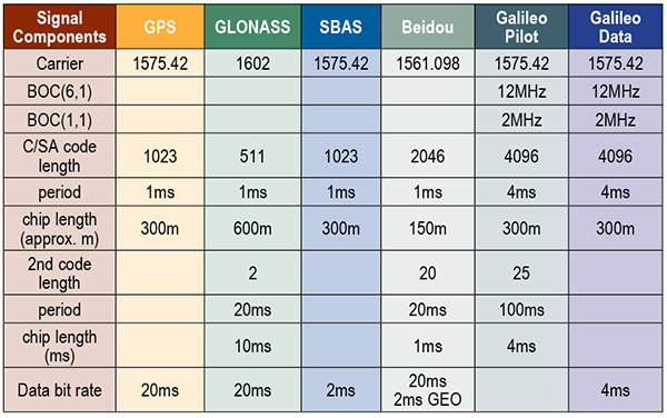
    Table 1. Parameters for all L1 GNSS signals.
    Table 1. Parameters for all L1 GNSS signals.

    Radio Overview

    The radio processing starts with a LNA, which utilizes a 72-nanometer negative metal oxide semiconductor transistor in a cascade configuration, with deliberate capacitive feedback and inductive source degeneration to achieve an excellent noise figure (~1.5 dB system noise figure) while maintaining a good input match. Two external matching components are required to achieve an optimal input match.

    Following the LNA is an in-phase/quadrature ring mixer switched-capacitor mixer. With this style of mixer, the LNA output is only connected to one mixer output at a time and, thus, the optimal noise figure is obtained. By switching the output of the LNA from the I+ output and then later to the I– output, a 2:1 voltage gain is achieved. This improves noise figure and eases the noise requirements of the IF amplifier following the mixer, thus reducing power consumption.

    The local oscillator for the mixer is derived from a low-power, low phase-noise, phase-locked loop. It has many adjustments, so the circuit can be adapted to a wide variety of reference frequencies and system requirements. It employs a ΔΣ modulator in the feedback loop, allowing for very fine frequency-control resolution.

    The complex IF output from the mixer is amplified by a transimpedance section followed by three parallel amplifier/filter/attenuator sections, one for GPS/Galileo/SBAS/QZSS, one for GLONASS, and one for BeiDou. The transimpedance section’s response is close to a simple pole but with a small amount of peaking. Each of the remaining sections is built with a single complex band-pass/band-notch section, followed by real poles and zeroes. Using real poles and zeroes considerably reduces the noise and bandwidth requirements of the amplifiers. The net effect is that the power consumption of the overall IF amplifier section is substantially reduced.

    There are three parallel ΔΣ analog-digital converters (ADCs), one for each of the three IF sections. The ΔΣ ADC is a continuous-time, second-order, one-bit ΔΣ ADC, running at a sample rate of 395.75 Msps. The ΔΣ ADC comprises two operational amplifiers, two digital analog converters, and a quantizer. The ΔΣ ADCs are designed in such a way that the quantization noise is lowest not at zero frequency offset (DC), but at the offset frequency of the GNSS signal. The A/D samples are filtered with a third-order cascaded integrator-comb subsampled at 99.44 mega-samples per second. Additional finite impulse response (FIR) filters and subsampling to 33.1 MHz complete the sampling. The combined ΔΣ ADC and digital filtering provide more than 50 dB of dynamic range.

    Digital processing at 33.1 MHz includes several filters that remove interference sources from the received radio signal and automatic gain control logic that adjusts the gain of the IF amplifiers to give an optimal signal level. A configurable 20-tap FIR filter is provided for each sample section and can be configured to remove wideband blockers. In addition, each section has eight narrowband, single-pole infinite impulse response filters for removing narrowband blockers.
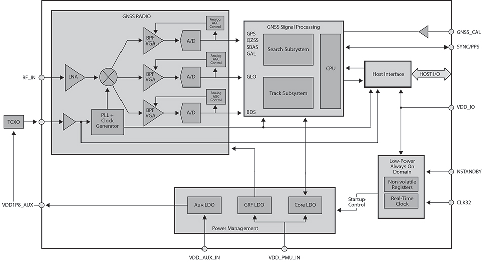
    Figure 1. Radio overview diagram.
    Figure 1. Radio overview diagram.

    Separate Search and Track Blocks

    Separate search and track sections are employed to compute correlations between the three sample streams and multiple reference hypotheses. The three sample streams are buffered in memory to allow the search and track sections to process multiple correlations in parallel. Search employs a prime factor fast Fourier transform with a selectable size (1023, 2046, or 4092).

    Search correlations are computed by first removing a hypothesis Doppler from a buffered set of samples and then combining a selectable number of code epochs. The filtered samples are translated to the frequency domain, multiplied by the frequency-domain representation of the desired PRN code, and finally translated back to the time domain. This process creates a coherent correlation vector for the entire code. The coherent correlation vector is non-coherently accumulated until the signal-to-noise ratio of the peak exceeds a detection threshold.

    Track correlations are computed in the time domain by multiplying a multichip reference code by a set of buffered samples. Typically, the reference code is linearly delayed for N correlations to produce an N-sample coherent correlation vector. The correlation vectors are buffered to allow multiple filters to be processed in parallel. A coprocessor is used to run the filters. The outputs from the coprocessor provide estimates of code phase, Doppler, acceleration, data synchronization, data bits, signal power, and more.

    All the buffering and multiple processing sections allow for multiple hypotheses to be tested in parallel. For example, on a tunnel entry, the attenuated signal can continue to be tracked while the search section tries to detect the full-power signal.

    Secondary Code Resolution. Several constellations have secondary codes that limit the length of the coherent integration unless the code can be wiped. GLONASS has a 100-Hz Manchester code, BeiDou has a 1-kHz secondary code, and the Galileo Pilot has a 250-Hz secondary code. After the time accuracy drops below 1 millisecond, all of the secondary codes can be wiped in both search and track, so the coherent period can be optimized to maximize sensitivity and minimize measurement error. On a cold start, when time is unknown, it is best to first try to detect with coherent correlations less than the secondary code chip period.

    When a signal is detected, the receiver either goes into track and computes correlations with longer coherent periods for multiple time hypotheses or continues in search with a longer coherence period and multiple time hypotheses. The search and track sections allow for either of these choices. For constellations like Galileo, the best choice is to remain in search. For others like BeiDou, it is best to move to track.

    Benefits of Multi-GNSS Receivers

    The ability to track all L1 constellations means that even in difficult environments, there are a sufficient number of satellites to produce a navigation solution. As can be seen from field-test results, not only are more satellites tracked, but more satellites with strong signals are tracked. The measurement errors of satellites received with strong signals will be smaller, leading to very low bit-error rates and allowing for a faster ephemeris collection. Field test results confirm that a receiver with BeiDou support achieves faster and more accurate fixes than a receiver without BeiDou support (see Figure 2).
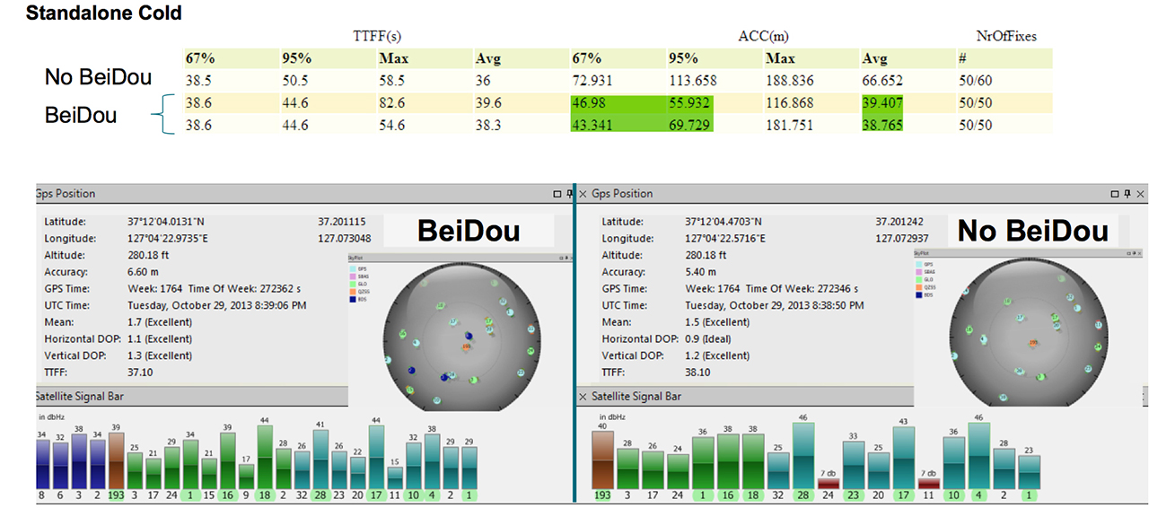
    figure 2 A receiver with BeiDou support achieves faster and more accurate fixes than a receiver without BeiDou support.
    Figure 2. A receiver with BeiDou support achieves faster and more accurate fixes than a receiver without BeiDou support.

    In addition to speed and accuracy improvements, more constellations provide a higher reliability. Recently, an upload error in the GLONASS constellation caused otherwise healthy satellites to report orbit errors of several kilometers. GPS/GLONASS-only systems could not completely isolate the faulty satellites. In difficult environments, there are not enough good satellites to isolate the faulty ones. With the addition of BeiDou, the faulty satellites were correctly isolated (Figure 3).
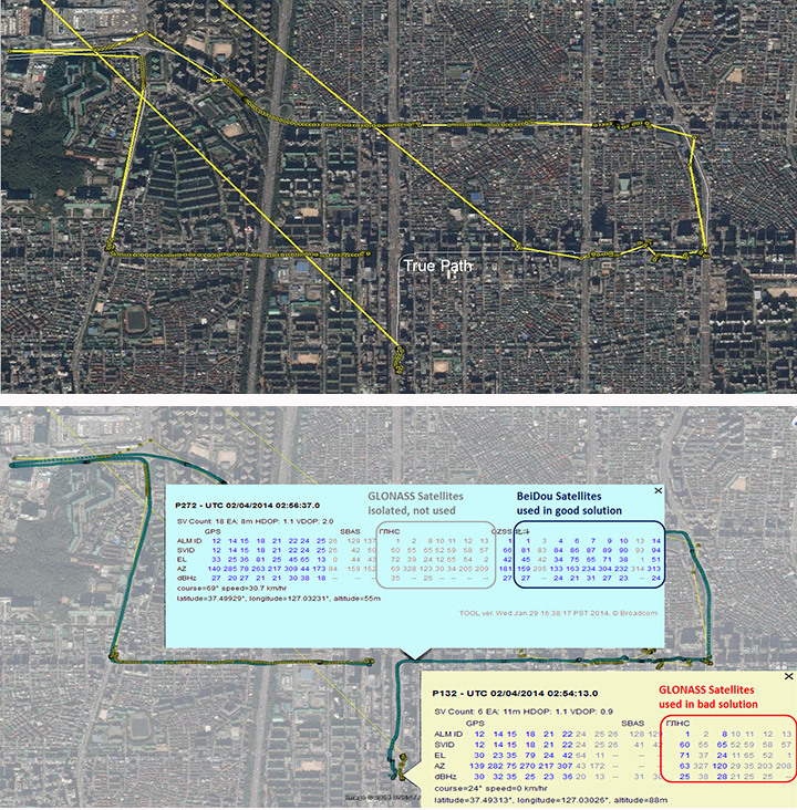
    figure 3 (Top) Seoul, South Korea, third-party GPS/GLONASS-only receiver; (bottom) Broadcom GPS/GLONASS/BeiDou receiver enables isolation of faults.
    Figure 3. (Top) Seoul, South Korea, third-party GPS/GLONASS-only receiver;
    (bottom) Broadcom GPS/GLONASS/BeiDou receiver enables isolation of faults.

    Each constellation adds unique improvements. Narrowing the correlation triangle allows for improved multipath rejection and more accurate pseudorange measurements (Figure 4).
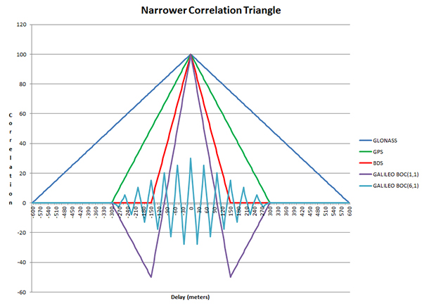
    Figure 4. Narrower correlation triangle.
    Figure 4. Narrower correlation triangle.

    GLONASS, with the slowest code rate, has the broadest correlation triangle. BeiDou, with the highest code rate, has a correlation triangle that is narrower than GPS. The BOC code on Galileo gives the narrowest correlation triangle. Field test results confirm the improved measurements (Figure 5).
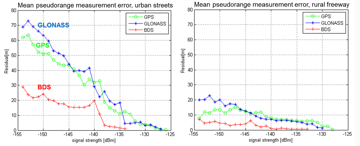
    Figure 5. Left, mean pseudorange measurement error, urban streets; Right, rural freeway.
    Figure 5. Left, mean pseudorange measurement error, urban streets; Right, rural freeway.

    GLONASS, the only FDMA constellation, has the least cross-correlation. GPS uses Gold codes to keep the cross-correlations between any of its satellites at a minimum. BeiDou and Galileo have lengthened their codes and added a secondary code to reduce cross-correlations.

    Conclusion

    Taking advantage of similarities in the L1 GNSS constellations together with careful design choices to minimize size and current consumption has enabled the creation of commercial GNSS system-on-chips that support all current GNSS L1 systems and meet the cost, size, and power requirements of cellular phones. The addition of new constellations like BeiDou and Galileo has significantly improved speed, performance, and reliability.

    Acknowledgments

    Javier de Salas, Frank van Diggelen, and John Hutson, all of Broadcom.

    Manufacturer

    The BCM4774 single-chip GNSS location hub for smartphones with Galileo support was designed by Broadcom Corporation.


    Charles Norman is a technical director in the GNSS group at Broadcom Corporation. Previously, he worked on GNSS systems at Magnavox, Interstate, SIRF, and RFMD. He holds 39 issued patents on GNSS systems and has an M.A. in mathematics from the University of California-Los Angeles.

    Andreas Warloe is a senior technical director in the GNSS group at Broadcom Corporation. He previously worked on GNSS receivers at Magellan, Leica Geosystems, IBM, and RFMD. He holds an M.S. in electrical engineering from the University of Southern California.
     

  • Russian Airline Approved for GNSS Landings

    Russia’s S7 Airlines has received approval for three Boeing 737-800s to perform landings using GNSS, becoming the country’s first carrier to do so, reports Air Transport World.

    According to an S7 statement, more than 50 airports in Russia have installed equipment allowing global positioning landings (GLS). Russia’s State Air Transport Management Corp. plans to certify 10-15 airports per year for GLS landing.

    “GLS will allow the airline to improve flights’ regularity, which is one of our priorities,” Globus Airline CEO Vadim Klebanov said. Globus Airline is a member of the S7 Group.

  • CES: Visteon Demonstrates Connectivity Gateway for Connected Car

    Visteon Corporation is demonstrating its latest vehicle connectivity system at the 2015 International CES being held this week in Las Vegas. Visteon’s system provides a secure and reliable gateway to advance the connected driving experience for drivers and automakers, the company said.

    A robust vehicle communication gateway is essential to ensure reliable connectivity that can keep pace with advances in 4G LTE, Wi-Fi, and vehicle-to-vehicle and vehicle-to-infrastructure (V2X) developments. Visteon’s latest solutions address personal and vehicle security, increased data complexity and vehicle architecture challenges.

    Visteon’s Wireless Gateway is a 4G-compatible connectivity module that manages a complex network of GPS, cellular, Wi-Fi and Dedicated Short Range Communications (DSRC) inside and outside of the vehicle to provide seamless connectivity when mobile. The gateway incorporates a high level of security to protect multiple owners over a vehicle’s lifetime and is capable of handling future data bandwidth, wireless communication and security needs.

    Visteon’s V2X platform provides short- to medium-range wireless communications between similarly equipped nearby vehicles that permit very low latency data transfer, which is critical in communications-based active safety applications. The platform is designed to maximize communication range and provide the greatest amount of warning or notification time to the driver.

    Addressing the connected vehicle architecture, Visteon’s SmartCore integrated solution integrates traditional driver information, infotainment and connectivity through one seamless human-machine interaction (HMI). Multiple domains can run side-by-side on scalable hardware through different operating systems, greatly reducing complexity, Visteon said. The system actively prioritizes critical information for the driver on a situational basis and enhances driver information management on the road to autonomous driving.

    “With the increased complexity of connected services and applications, today’s challenge is not about providing a platform with extensive features, but creating a future-ready vehicle gateway that has the flexibility to adapt and accommodate evolving network technologies,” said Christian Feltgen, vice president, Visteon technology office.

  • UN, Roscosmos Plan GNSS Economic Workshop

    The United Nations and Russia’s space agency ROSCOSMOS are holding a workshop on ways to use GNSS for sustainable social and economic benefits. The workshop will be held May 18-22 in Krasnoyarsk, Russian Federation.

    The United Nations/Russian Federation Workshop on the Applications of Global Navigation Satellite Systems is organized jointly by the United Nations Office for Outer Space Affairs and the Russian Federal Space Agency (ROSCOSMOS). The workshop will address the use of GNSS for various applications that can provide sustainable social and economic benefits, in particular for developing countries.

    Current and planned projects that use GNSS technology, including the GLObalnaya NAvigatsionnaya Sputnikovaya Sistema (GLONASS) of the Russian Federation, for both practical applications and scientific explorations will be presented. Cooperative efforts and international partnerships for capacity-building, training and research, including the activities of the GLONASS learning center will also be presented.

    The workshop program will include plenary sessions described below and also sufficient time for discussions among participants to identify the priority areas where pilot projects should be launched and examine possible partnerships that could be established.  In addition, a half-day technical tour will be arranged by the Local Organizing Committee during the workshop.

    The workshop is co-organized and co-sponsored by the International Committee on Global Navigation Satellite Systems, and hosted by the Reshetnev Information Satellite Systems Joint Stock Company.

    Sessions include:

    • Session 1: Current and Planned GNSS and Satellite-Based Augmentation Systems
    • Session 2: GNSS-based Applications
    • Session 3: GNSS and Space/Atomospheric Weather Monitoring
    • Session 4: GNSS Reference Frames/Systems and Reference Station Networks
    • Session 5: Capacity building, training and education in the field of GNSS

    Visit the UNOOSA website for more information.


  • GNSS: The New GPS

    GNSS: The New GPS

    First of all, on behalf of all of us here at GPS World magazine, allow me to welcome you to 2015. We wish you a healthy and prosperous new year!

    I’d like to start out the new year stating the obvious for some of you, maybe most of you…perhaps all of you: GNSS is the new GPS.

    In the high-precision GNSS community, I think this is already our mindset, and has been for quite some time. The benefit of using signals from as many satellite navigation systems to the high-precision user is obvious. We saw this with the adoption of GLONASS more than a decade ago. It’s to the point now that even many consumer receivers (such as my Samsung Galaxy S5) utilize both GPS and GLONASS satellites.

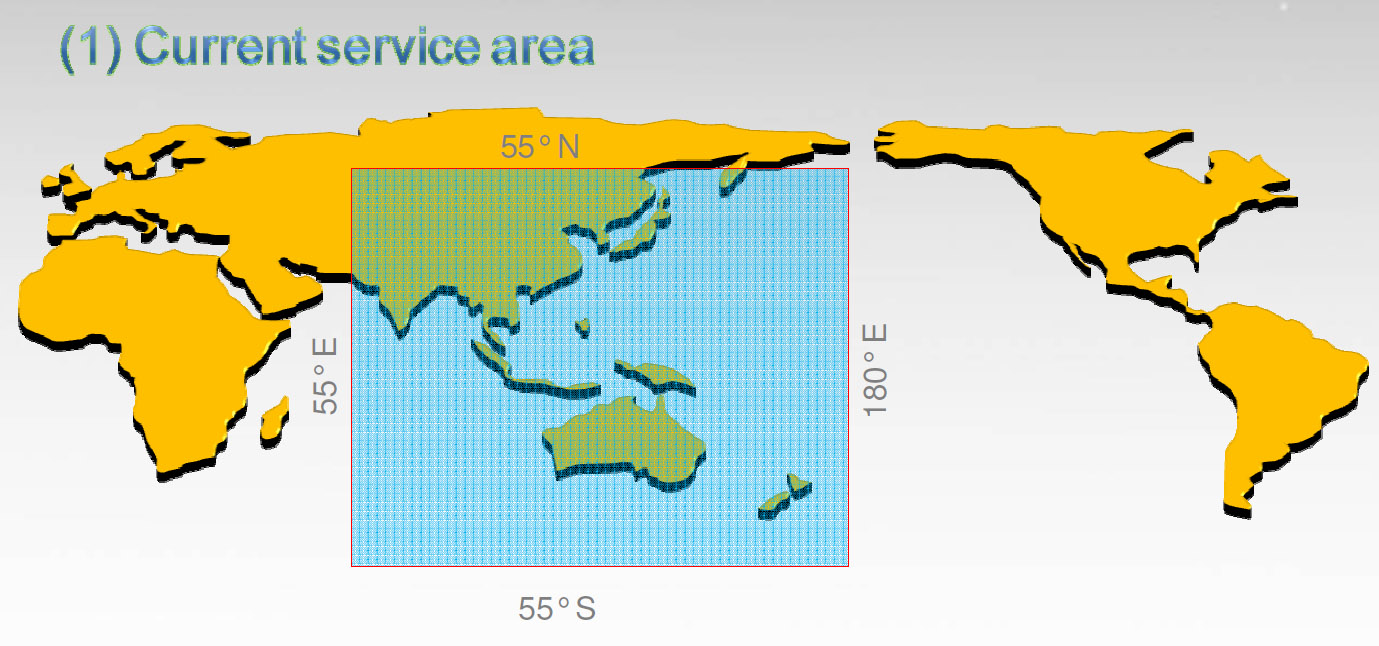
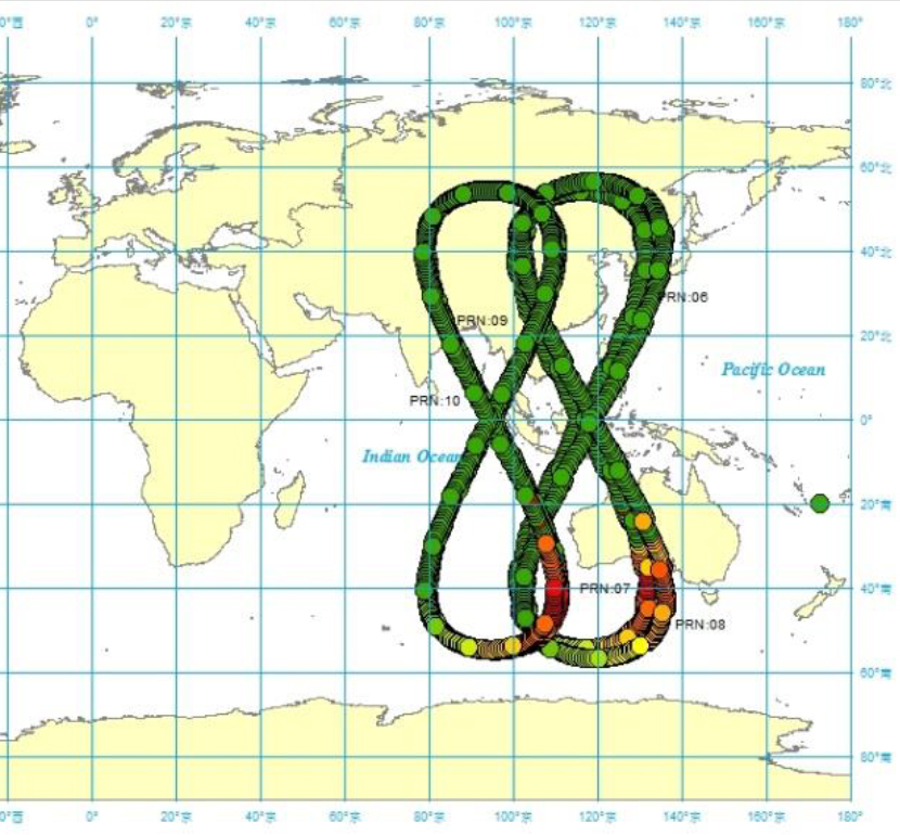
    I think it’s pretty obvious we’ll see the same phenomenon with Galileo (Europe) and BDS (China’s BeiDou system). It’s exciting to think about what high-precision GNSS positioning is going to look like just 2-3 years from now. Think about how much better RTK positioning will be with 30+ satellites in view. By the way, that’s already a reality in China where BDS has 14 regional satellites in addition to GPS and GLONASS. It’s the best place in the world for RTK positioning due to the number of satellites in view at any one time, and it might be the reason that China consumes more RTK receivers than the rest of the world combined.

    BDS coverage area
    BDS coverage area.


    BDS satellite orbit map
    BDS satellite orbit map.

    I certainly look forward to the deployment of Galileo and BDS. It will only make us more productive in accomplishing our work. Yet I’m reminded frequently when reading mainstream news headlines that Galileo, BDS, and GLONASS compete with GPS. Even some of those who hold GPS dear to their hearts, such as those who were involved in the development, promotion and deployment of GPS, view the other satellite systems as competition.

    Maybe that’s not a bad thing because competitors push each other to perform better. However, where it might hurt is when it comes to support, such as funding. Galileo, in particular, because it’s funded with civil funds instead of defense funds like GPS and GLONASS, has been criticized as a wasteful use of resources because GPS already exists. What more can it add, they ask? The mainstream media doesn’t have a clue that the satellite navigation systems are complementary rather than competitive. You and I know that more satellites generally equates to increased productivity no matter who owns/operates the satellite that is sending the signal. I cringe when I read these headlines:

    News Headlines

    GPS and its Three Main Competitors: Galileo, Beidou, GLONASS

    GPS vs. Galileo; Where Are They Headed?

    China Spreads Alternative To U.S. GPS System

    China’s Beidou Navigation Satellite System More Precise than GPS in Certain Areas

    GPS vs GLONASS: Which Is Best for Tracking Applications?

    Generally, I dismiss the mainstream media in the GNSS arena, but these misleading articles can have an impact on funding of the various GNSS, such as Galileo. Politicians and various purse-string holders can be influenced by these stories.

    Galileo Moving Forward

    The Europeans are pushing forward after the recent hiccup when the first two Full Operation Capability (FOC) Galileo satellites were inserted in the incorrect orbits due to an improper fuel line installation on the rocket launcher resulting in the satellites being inserted in an orbit far below its intended orbit (an elliptical orbit, 49.8 degrees at 26,200 km, vs. the intended circular orbit, 55 degrees at 29,900 km).

    In October 2014, shortly after the faulty launch, the outlook for the two satellites was bleak. The consensus was that there was no feasible method to move the satellites to their intended orbits. The good news was that besides the fact that they were in New York instead of Los Angeles :-), they checked out healthy, were properly oriented to the sun, and were “thermally stable.” Would they join GPS SVN-49 in being demoted to permanent test mode status, never being allowed to join the operational constellation, further delaying the deployment of Galileo? Not so.

    In late October, flight engineers used a series of fuel burns, using more than 75 percent of its fuel payload, to boost the satellite 3,500 km further into space, into a more circular orbit. While the original, incorrect orbit “prevented their use for navigation services because they were too low during part of their orbit to sense the horizon and correctly determine their own position,” the new orbit, not quite the intended orbit, seems sufficient to allow the satellite to perform most of its intended duties, including being incorporated into Galileo’s operational constellation.

    The first live test was completed on December 9, 2014, when the satellite was one of four Galileo satellites that delivered a position fix of better than two meters. Furthermore, in a January 1 article published on GPS World’s website, Peter Steigenberger and André Hauschild of the German Aerospace Center wrote that the rogue Galileo FOC satellites can likely be used by commercial, multi-frequency, high-precision GNSS receivers for carrier-phase positioning. One drawback is that because the satellite’s orbit doesn’t fall within the limits of the standard Galileo almanac, it may take receivers longer to begin tracking the satellite.

    Flight engineers are now working on maneuvering the second rogue Galileo satellite in the same manner, hoping for the same result.

    All in all, this is about as good of a result that could possibly be expected. My hat’s off to the folks who made this happen.

    Meanwhile, the next four Galileo FOC satellites are moving through the production process. Originally slated for a December launch, I suspect last year’s launch anomaly had the Galileo folks double-triple-quadruple checking, dotting i’s and crossing T’s, so make sure the next launch has the best chance of success. They haven’t announced a new launch schedule yet, but I would guess it’s likely in the next six months, with quarterly launches resuming if things goes smoothly. If all goes well, we could be benefiting from 10 healthy Galileo satellites by the end of the year.

    Thanks, and see you next time.

    Follow me on Twitter at https://twitter.com/GPSGIS_Eric

  • Android Wear App with AccuWeather MinuteCast Now on Google Play

    Android Wear App with AccuWeather MinuteCast Now on Google Play

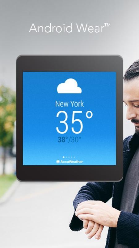
    AccuWeather App for Android Wear (PRNewsFoto/AccuWeather)
    AccuWeather App for Android Wear (PRNewsFoto/AccuWeather)

    The AccuWeather app for Android is now available for Android Wear, providing users with up-to-the-minute weather information wherever they go. Android Wear is the Android platform for wearables such as smartwatches. The app is available through the Google Play store.

    AccuWeather’s app for Android Wear features AccuWeather MinuteCast, a global minute-by-minute precipitation forecast for a person’s exact street address or GPS location. AccuWeather MinuteCast includes precipitation type and intensity, as well as start and end times for precipitation, and gives users by-the-minute precipitation forecasts for the upcoming two hours. The GPS technology that localizes the weather to the user’s location is protected by patents in the United States and many of the major countries around the world, AccuWeather said.

    In addition to AccuWeather MinuteCast, AccuWeather for Android Wear and for Android smartphones and tablets provides users with severe weather alerts, hourly forecasts, and current conditions.

    “This is an exciting opportunity for AccuWeather to deliver weather information in innovative new ways to users,” said Steven Smith, chief digital officer of AccuWeather, Inc. “As the global weather leader, we provide weather forecasts wherever, whenever, and however our users most want them. Easy access, hyper localization, ease of use, and the superior accuracy that is the hallmark of our organization, help our audiences everywhere make decisions and improve their lives.”

    AccuWeather MinuteCast is available for the contiguous United States, Canada, Japan, Ireland, France, Germany, Belgium, Switzerland, Netherlands, Luxembourg, the United Kingdom, and parts of the Czech Republic, with additional locations to come.

    AccuWeather for Android Wear, and for Android smartphones and tablets, is available from Google Play.

  • GPS Watch Aimed at Children’s Safety Unveiled at CES

    GPS Watch Aimed at Children’s Safety Unveiled at CES

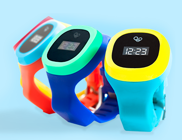
    The HereO GPS watch for children. Photo: HereO
    The HereO GPS watch for children. Photo: HereO

    The hereO cellular GPS watch for kids will be officially unveiled at the 2015 International CES, being held in Las Vegas this week. Designed for children ages three and up, the hereO works in sync with a mobile app to provide real-time location sharing, safe-zone alerts, and group messaging, allowing parents to monitor their children’s safety and whereabouts at all times directly on their mobile phones or desktop computers.

    The engineers at hereO miniaturized components to make the watch fit children’s wrists, the company said. The watch comes in a variety of bright and colorful water resistant designs to appeal to children. For parents, the hereO Family App for smartphones/tablets (iOS and Android) and desktops provides real-time location information on all family members and loved ones, plus location history, live-updates, panic alerts, safe-zone definition, and more.

    “CES is a crucible of amazing minds, emerging ideas, and groundbreaking new technology; it’s the Mecca for today’s most inspired innovators,” said hereO Co-Founder and President Daniel Ivesha. “After three years of developing and perfecting our prototype, we couldn’t think of a better place to debut hereO, the world’s smallest cellular-connected GPS tracking watch for kids, which we believe is not only a game-changer in child safety technology but in the way families stay connected.”

    Features include:

    • hereO LOCATION: Parents can locate their child anytime, anywhere. Historical locations are also available so parents can track where their child have been throughout the day.
    • Wi-Fi ENABLED: Wi-Fi allows indoor tracking whenever an indoor map is available. When indoor mapping is unavailable, an indoor confirmation will be sent to the parent’s smartphone.
    • SAFE-ZONE ALERTS: Parents can create Safe Zones for frequently visited areas (kindergarten, office, etc.) and are notified when their child arrives or departs from that location.
    • PANIC ALERT: In case of an emergency, children can use their hereO watch to send a panic alert that immediately notifies family members of their location.
    • TAMPER ALERT: Parents receive an alert when any authorized person tries to remove the watch.
    • EMERGENCY TRACKING: In emergency situations, parents can turn on real-time tracking to facilitate locating the child.
    • TIME DISPLAY: Time is displayed on a beautiful e-ink display.
    • USB charger: Built-in USB connector allows portable charging. Simply plug the hereO watch into any USB port to charge and to get firmware updates.
    • LONG BATTERY LIFE: With our standby mode, the hereO watch can last up to 60 hours.
    • BUILT-IN SIM: Each hereO watch is equipped with a built-in SIM card that works in over 120 countries, making it the perfect travel companion.

    The hereO watch retails for $179, which includes a three-month subscription to the hereO Family App. Thereafter, a monthly fee of $4.95 applies.

    At CES, the hereO watch is at booth #74545 (Tech West: Sands Expo at The Venetian).

  • CES: Hobbico Demonstrates Drone System for Aerial Photos

    The Hobbico ORA, a new drone system for aerial photographers, is being demonstrated at the 2015 International CES, running January 6-9 in Las Vegas. The camera-equipped drone displays captured aerial images on a seven-inch touchscreen integrated into the transceiver. With a 370-mm diameter and an onboard 1080p HD camera, the ORA also delivers high-quality images, reliability and long range through its recording method and choice of radio frequencies.

    Designed for taking aerial views of action sports, outdoor weddings, real estate, vacation vistas and more, the ORA delivers out-of-the-box aerial photo and video capture with no need for radio-control piloting experience. All images are recorded on an SD card built into the drone, providing higher resolution than systems that use the transceiver for data capture, Hobbico said. Use of the 5.8-GHz radio band instead of the typical 2.-4GHz or Wi-Fi ensures a robust connection and a 500-meter flight control and video signal range.

    The seven-inch first-person view touchscreen built into the ORA transceiver displays what the UAV’s onboard camera sees in real time, eliminating the need to use a cell phone, tablet or other third-party device to view captured images. Users can frame scenes exactly as they want them filmed by remotely controlling the camera gimbal. One-, two- and three-axis gimbal options are available, each designed also to accept GoPro cameras.

    The transceiver has an integrated Android device for programming ORA functions through the touchscreen. A separate OLED telemetry screen displays flight data such as GPS coordinates, altitude and battery power status.

    Other highlights include:

    • 30 minutes of flight time per battery charge
    • Built-in GPS programming that puts flight routes, speed and altitude on auto-pilot
    • Support for 32 separate GPS waypoints to execute complex flight patterns
    • The ability to hold a steady altitude and position via GPS to film desired scenes
    • The option to save coordinates and fly the identical path again any number of times.

    Selecting “Return to Home” brings the ORA back to its pilot with a single command. An “Actual Direction” option prevents control reversal confusion during manual flight — when activated, the quad always moves in the same direction as the control sticks. Additional failsafe systems watch for dangers such as low-battery power and automatically bring the ORA and camera home for safe landing.

    The Hobbico ORA is scheduled for early 2015 release at an MSRP of $1,500-$2,000 depending on the battery, gimbal and camera configuration. The package will include the drone, 10-channel touchscreen transceiver, gimbal, batteries and charger.

    The drone is on display at CES Booth #25214 in the Unmanned Systems Marketplace at the Las Vegas Convention Center’s South Hall 2.

  • FAA Grants Two More UAV Exemptions

    FAA Grants Two More UAV Exemptions

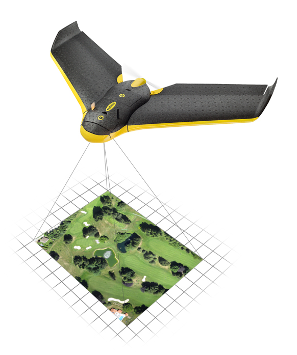
    The eBee Sensefly UAV.
    The eBee Sensefly UAV. Photo: Advanced Aviation Solutions

    The Federal Aviation Administration (FAA) today granted two more regulatory exemptions for unmanned aircraft systems (UAS) operations for commercial use.

    The FAA granted five exemptions to four companies in December.

    The two companies are Advanced Aviation Solutions of Spokane, Wash., and Tierra Antiqua Reality of Tuscon, Ariz. Advanced Aviation Solutions plans to fly an eBee senseFly UAV Ag system carrying a georeferenced still camera to conduct photogrammetry and crop scouting in order to perform precision agriculture.

    The eBee Ag system consists of a 1.5-pound battery-powered aircraft, a personal computer-based ground control station, and associated communications equipment. The UAV is a fixed-wing aircraft with a wingspan of about 3 feet and 2 feet in overall length, which can operate at a maximum speed of about 50 knots.

    Tierra Antiqua Reality plans to operate a Phantom 2 Vision+ UAS, which is comprised of an unmanned aircraft and a transportable ground station. The company plans to attach a small ultra-6 lightweight GoPro 3+ camera to the Phantom and operate it over various areas near Tucson to enhance academic community awareness and augment real estate listing videos.  

    The Phantom is a 3-pound quadcopter with a maximum airspeed of 30 knots.

    The Phantom quadcopter.
    The Phantom 2 Vision quadcopter. Photo: Phantom
  • New ARCHIBUS Release Streamlined for GIS

    ARCHIBUS, Inc., has announced the latest release of its ARCHIBUS software suite. Designed to streamline work processes through enhanced mobile apps, GIS, and building information modeling (BIM), now real estate, facilities, and asset management professionals will find in ARCHIBUS an intuitive business intelligence platform that will help reduce their total cost of ownership by connecting real estate, facilities, and asset management information with their corporate business organization and systems.

    New productivity-enhancing capabilities of ARCHIBUS cover a wide range of organizational needs including the introduction of new features for the Mobile Framework Apps, the addition of GIS capabilities for geo-referencing everything from equipment to buildings, and integration of facilities information with BIM data for end-to-end, intelligent building lifecycle management. Capital project lifecycle management is streamlined with the new project management console that correlates and presents all information on a single screen.

    In this product release, ARCHIBUS has simplified integration with other EAM and ERP systems via ARCHIBUS connectors that enable data sharing with Microsoft, Oracle, Sage, SAP, UFIDA, and other enterprise or point systems. Industry standard transfer formats, such as OSCRE, COBie, and buildingSmart IFC are also used.

    New productivity-enhancing capabilities of ARCHIBUS cover a wide range of organizational needs including the introduction of new features for the Mobile Framework Apps, the addition of GIS capabilities for geo-referencing everything from equipment to buildings, and integration of facilities information with BIM data for end-to-end, intelligent building lifecycle management. Capital project lifecycle management is streamlined with the new project management console that correlates and presents all information on a single screen.

    A new generation of workplace services offers self-service requests for repairs, reserving meeting rooms, along with booking support services from practically anywhere in the world. The new product release of ARCHIBUS enables users to achieve their organization’s objectives by providing business intelligence to real estate, facilities, and asset management information for immediate tactical actions and strategic, enterprise-wide decision-making.

    “We are excited to bring this new release of ARCHIBUS to the marketplace. It is positioned to deliver to organizations worldwide greater operational efficiency and customer responsiveness through our expanding suite and the capabilities of our product offerings, management consoles, EAM and ERP integration, as well as many other enhancements and innovations,” said ARCHIBUS, Inc. President and CEO Bruce K. Forbes. “’Simplicity through Intelligence’ is a critical element for the success of ubiqitous infrastructure and facilities management solutions.”


  • China’s FOIF Offers A50 GNSS Survey Receiver

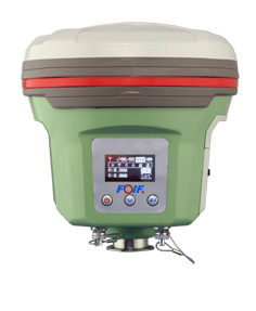
    A50 GNSS receiver.
    A50 GNSS receiver. Photo: FOIF

    Chinese company FOIF is offering a new survey receiver, the A50. FOIF said that with the A50, the company focused on developing a smart design for a receiver to make it lightweight, yet powerful, making it easy to use for fieldwork. Besides Bluetooth, wireless radio, and mobile network (2G and 3G), Wi-Fi feature was added to broaden data communications for GNSS. The A50 is designed to provide excellent performance, with a high-sensitivity GNSS module.

    According to FOIF, the A50 has not only sophisticated onboard software, but also optional application programs such as FOIF FieldGenius and Carlson SurvCE, providing multiple field solutions.

    The A50’s features include:

    • Wi-Fi to achieve quick and long distance parameters settings and data transferring;
    • Tracking of GPS, GLONASS, Galileo, BeiDou satellites on 220 channels;
    • An industry-standard GNSS engine (Trimble, NovAtel) that can access local CORS;
    • horizontal real-time accuracy (rms) of 10mm+1ppm, and vertical of 20mm+1ppm;
    • OLED display with superior brightness and temperature range
    • Rugged design, with an IP67 rating;
    • Voice messaging.
    RTK<30km

    H:8 mm + 1 ppm

    V:15 mm + 1 ppm

    DGPS H:0.25 m + 1 ppmV:0.50 m + 1 ppm
    SBAS 0.5m (initialization time < 10s, initialization reliability > 99.9%)
    Static

    H:±(2.5+1×10⁻⁶×D) mm

    V:±(5+1×10⁻⁶×D) mm

  • CES: Magellan Launches RoadMate Auto GPS Devices with 3D Landmarks

    CES: Magellan Launches RoadMate Auto GPS Devices with 3D Landmarks

    The Magellan RoadMate 5375T-LMB.
    The Magellan RoadMate 5375T-LMB.

    Magellan has introduced its newest lineup of 5-inch RoadMate auto navigators at the International Consumer Electronics Show, being held this week in Las Vegas. To provide a more realistic view of a user’s surroundings, each of the GPS models comes equipped with 3D renderings of buildings and landmarks.

    The new models are: RoadMate 5322-LM, RoadMate 5330T-LM with real-time traffic alerts, and RoadMate 5375T-LMB with real-time traffic alerts, Bluetooth connectivity and portrait viewing mode.

    The units will be displayed at CES in the Magellan booth, LVCC South Hall 2, MP25441.

    “Our new RoadMate 5-inch GPS devices for 2015 have large, vibrant displays and include a vast collection of renowned Magellan navigation features,” said Stig Pedersen, Magellan associate vice president of product management. “Plus, each model includes 3D renderings of buildings and landmarks to make it easier and quicker for users to identify where they are. Whether driving to work, across country, or going to grandma’s, drivers can count on these Magellan navigation units to safely guide them to wherever their destination is.”

    Below are a few of the features that the three RoadMate GPS devices share.

    • 3D Renderings – Selected buildings and landmarks are presented in 3D for a more realistic view.
    • Lifetime Map Updates – Owners of these three models can download the latest map information (up to four times a year) for all 50 states and Canada.
    • Landscape Viewing Mode – Provides improved peripheral view.
    • Traffic Camera Alerts – Sends audible and visual warnings of upcoming red lights, speed cameras, and more; provided by PhantomALERT.
    • 7,000 POIs – Includes branded and highway exit POIs to conveniently search for restaurants, hotels, gas stations, and more.
    • OneTouch Favorites Menu – Creates shortcuts to favorite destinations and searches.
    • Multi-Destination Routing – Users can plan their entire day or multi-day trip in one route.
    • Junction View – Realistic images of freeway signs and arrows guide drivers to the correct lane.
    • SmartDetour – Provides immediate options when traffic suddenly comes to a halt.

    RoadMate 5330T-LM

    In addition to the features above, the 5330T-LM also includes:

    • Free Lifetime Traffic Alerts – Helps users avoid traffic jams and delays, suggests detours, provides travel times; no hidden fees or subscriptions.

    RoadMate 5375T-LMB

    In addition to the features above, the 5375T-LMB also includes:

    • Free Lifetime Traffic Alerts – Helps users avoid traffic jams and delays, suggests detours, provides travel times; no hidden fees or subscriptions.
    • Portrait Viewing Option – Provides extended view of the road ahead.
    • Bluetooth Compatibility – Turns this RoadMate model into a hands-free speakerphone, making drive time safer and more productive.

    The Magellan 5-inch RoadMate family of auto navigation devices will be available at retailers throughout the U.S. and Canada as well as online in March 2015. MSRPs are as follows: $149.99 (RM5322-LM); $159.99 (RM5330T-LM); and $199.99 (RM5375T-LMB).